
Apple Valley City Zoning Code
CHAPTER 9
71 - Subdivision Regulations
9.71.010 - General Provisions
A.
Title. This Chapter is the Town of Apple Valley Subdivision Ordinance.
B.
Purpose and General Plan Consistency (66411)(1). [12] The regulations set forth in this Chapter are determined to be necessary for the preservation of the public health, safety and general welfare and for the implementation of the goals and objectives of the Town of Apple Valley General Plan. The purpose of this Chapter is multi-faceted as follows:
1.
Conform to the Town's General Plan. To create lots of reasonable utility and livability in conformance with the General Plan; and
2.
Orderly growth. To provide for the orderly growth and harmonious development of the Town of Apple Valley through the regulation and control of the division of land for the purpose of sale, lease or financing, wholly or partially within the Town of Apple Valley; and
3.
Implement the Subdivision Map Act. To supplement and implement the provisions of Chapters 1-7 of Division 2 of the Government Code of the State of California (the Subdivision Map Act) pertaining to the design, improvements and survey data of subdivisions; and
4.
Establish procedures. To establish procedures to be followed in securing the official approval of the reviewing authority, which may be the Town Engineer, the Director, the Planning Commission and/or the Town Council; and
5.
Ensure adequate traffic circulation. To implement the Circulation Element of the General Plan by ensuring adequate traffic circulation through coordinated street systems in relation to major thoroughfares, adjoining subdivisions and public facilities; and
6.
Comply with health and safety requirements. To secure adequate provisions for water supply, drainage, sewage disposal, traffic control and other health and safety requirements; and
7.
Consider public facilities. To ensure consideration of adequate sites for schools, recreation areas and other public facilities; and
8.
Conserve resources. To promote open space; conservation of resources, energy and land; and the protection of and proper use of land; and
9.
Conveyance of land. To promote the conveyance of land by accurate legal description.
C.
Applicability (66411 and 66454). This Chapter applies to any division of real property wholly or partially within the incorporated area of the Town except as specifically excluded by the Subdivision Map Act, this Chapter, or a development agreement adopted by ordinance of the Town Council. Divisions of land in unincorporated territory adjacent to the Town are subject to these provisions to the extent permitted by the Subdivision Map Act, Section 66454, Pre-annexation Filing of Tentative Maps.
D.
Conformance (66473.5). No land shall be subdivided and developed for any purpose unless it is in conformance with the Town of Apple Valley General Plan and any applicable Specific Plan, and unless it is in compliance with the Development Code of the Town. The type and intensity of land use shown in the General Plan shall determine the type of street improvements, utilities and other public services that shall be provided by the developer. All mandatory provisions of the Subdivision Map Act shall apply to land divisions and proceedings described in this Chapter, any provisions in this Chapter which appear inconsistent with said mandatory provisions of the Subdivision Map Act shall be construed and applied so as to be in conformance with those mandatory provisions.
E.
Subdivisions Creating Four (4) or Fewer Parcels; Waiver (66428). A Tentative and Final Parcel Map are required for all subdivisions creating four (4) or fewer parcels including condominium, townhouse, stock cooperative apartment or community apartment projects containing four (4) or fewer parcels. A Parcel Map is not required when the subdivision:
1.
Is for the construction of a condominium project on a single parcel; or
2.
Contains only parcels that are more than forty (40) gross acres or are not less than a quarter of a quarter section; or
3.
Is created for the purpose of creating a water well site of less than 1,200 square feet; or
4.
Is a portion of the operating right-of-way of a railroad corporation defined as such by Section 230 of the Public Utilities Code which are created by short-term leases (terminable by either party on not more than 30 days' notice in writing); or
5.
Is for land conveyed to or from a governmental agency, public entity, public utility, or for land conveyed to a subsidiary of a public utility for conveyance to such public utility for rights-of-way shall not be considered a division of land for purposes of computing the number of parcels; or
6.
Complies with the requirements of the Subdivision Map Act and this Chapter as to parcel size, improvements and design, flood water drainage control, improved public roads, sewage disposal facilities, water supply availability, environmental protection, and other requirements of the Subdivision Map Act and this Chapter, and provided that the boundaries of the parcels are adequately monumented. In such cases the Director, in consultation with the Town Engineer, may waive the requirement for a Parcel Map, including those Parcel Maps required by Section 66426 of the Subdivision Map Act and Section 9.71.010.F of this Chapter. Such waiver automatically constitutes approval for the issuance of a Certificate of Compliance as specified in Section 66499.35 of the Subdivision Map Act. When the Parcel Map requirement has been waived, the Director shall, within ninety (90) days and without further application and proceedings, file the Certificate of Compliance with the County Recorder.
F.
Subdivisions Creating Five or More Parcels (66426). A Tentative and Final Tract Map are required for all subdivisions creating five (5) or more parcels, condominiums, townhouses, stock cooperative apartment units, or a community apartment project containing five (5) or more parcels. For the subdivisions listed below a Tentative and Final Parcel Map may be submitted in place of the Tentative and Final Tract Map.
1.
The land before division contains less than five acres, each parcel created by the division abuts a maintained public street or highway and no dedications or improvements are required; or
2.
Each parcel created by the division has a gross area of 20 acres or more and has an approved access to a maintained public street or highway; or
3.
The land consists of a parcel or parcels of land having approved access to a public street or highway, which comprises part of a tract of land zoned for industrial or commercial development, and which has the approval of the governing body as to street alignments and widths; or
4.
Each parcel created by the division has a gross area of 40 acres or more or is larger than a quarter of a quarter section.
G.
Remainder Parcels (66424.6). A Remainder Parcel is that portion of an existing parcel that is not included as part of the subdivided land. The subdivider may omit that portion of land from the map as an alternative to the "Remainder Parcel" designation.
The timing of the payment of fees associated with any deferred improvements are to be treated in the same way as the current law on improvements. However, the deferral of fees does not apply if the designated remainder or omitted parcel is included within the boundaries of a benefit assessment district or community facilities district.
H.
Processing Fees (66451.2). A fee, established by Resolution of the Town Council, is required for all applications or other filings required or permitted by this Chapter or the Subdivision Map Act. A current list of fees is available from the Planning Division.
I.
Community Apartment, Condominium, Townhouse and Stock Cooperative Projects (66412.g, 66427 and 66427.1). The requirements of the Subdivision Map Act and this Chapter shall apply to all Community Apartment, Condominium, Townhouse, Stock Cooperative and similar projects, except those excluded by the Subdivision Map Act and Section 9.71.010.J of this Chapter. Applications for the above projects are to be processed according to this Chapter.
J.
Exclusions (66412). No Tentative Map, Parcel Map or Final Map is required for the Following:
1.
The financing or leasing of apartments, offices, stores or similar space within apartment buildings, industrial buildings, commercial buildings, mobilehome parks, or trailer parks; or
2.
Mineral, oil or gas leases; or
3.
Land dedicated for cemetery purposes under the Health and Safety Code; or
4.
Lot Line Adjustments as specified in Section 66412.d of the Subdivision Map Act; or
5.
Boundary line or exchange agreements to which the State Lands Commission or a local agency holding a trust grant of tide and submerged lands is a party; or
6.
Any separate assessment under Section 2188.7 of the Revenue and Taxation Code; or
7.
The conversion of a Community Apartment Project as specified in Section 66412.g of the Subdivision Map Act; or
8.
The conversion of a Stock Cooperative Project as specified in Section 66412.h of the Subdivision Map Act; or
9.
The leasing of, or the granting of an easement to, a parcel of land, or any portions thereof, in conjunction with the financing, erection, and sale or lease of a windpowered electrical generation device on the land; or
10.
The financing or leasing of any parcel of land, or any portion thereof, in conjunction with the construction of commercial or industrial buildings on a single parcel; or
11.
The financing or leasing of existing separate commercial or industrial buildings on a single parcel; or
12.
Leases of land for agricultural purposes; cultivation of food or fiber or the grazing or pasturing of livestock; or
13.
Any other exclusions provided by the Subdivision Map Act and this Chapter.
(1) The numbers in parentheses indicate the corresponding sections of the State of California Subdivision Map Act.
9.71.020 - General Subdivision Standards (Amended Ord. 264, 265, 300)
A.
Circulation. The street pattern and street design of the proposed subdivision shall conform to the Circulation Element of the Town's General Plan, and:
1.
The street system in the proposed subdivision shall be related to the existing streets in the area adjoining the proposed subdivision; and
2.
The proposed street pattern shall consider the future land division and use of adjoining undivided property; and
3.
Part-width boundary streets in a subdivision adjacent to undivided land shall have a minimum right-of-way width of forty (40) feet.
B.
Lot Design
1.
Lot size is determined by the zoning district classification and the General Plan designation of the subject property.
2.
City, County, school, other district, or other taxing agency boundary lines may not divide a lot.
3.
Lot frontage is measured on a line at, intersecting or tangent to the midpoint of the building setback line.
4.
Side lot lines are to intersect street right-of-way lines at right angles wherever practicable.
C.
Access. All subdivisions shall abut a public street or have an approved access as follows:
1.
Each lot or unit within the subdivision shall have approved direct access to a public or private street.
2.
No new direct driveway access from individual residential lots onto divided major arterials, major arterials or secondary streets shall be permitted unless approved in writing by the Town Engineer.
3.
Access to residential property along freeways, expressways, major divided arterials, major highways, secondary arterials (unless no reasonable alternative exists), railroads, or flood control channels shall be provided by either a frontage road or a street separated by a tier of lots (reverse frontage lots). The Development Review Committee (DRC) may recommend the location of a street approximately parallel to and on each side of such right-of-way at a distance suitable for appropriate use of the intervening land. Such distance shall be determined with due regard to approach grades, drainage, bridges or future grade separation.
4.
When direct access to residential property from major divided arterials, major highways or secondary arterials is unavoidable, a circular driveway or turnaround shall be provided.
5.
For private streets, the subdivider shall provide an appropriate method for permanent maintenance subject to the approval of the Town Engineer and the Town Attorney.
6.
A Tentative Tract or Parcel Map shall provide at least two (2) different standard routes of ingress and egress. A standard route is a road dedicated to the Town and paved to Town standards.
7.
Multi-Use and Equestrian Trails. Where a project is located along bicycle and/or equestrian trails as shown in the General Plan, or in zoning which permits horse-sheltering as designated in the General Plan, trail improvements shall be provided in accordance with the Multi-Use and Equestrian Trails Standards document on file within the Town Clerk's office.
D.
Street Layout
1.
Street layout and design shall be consistent with the Circulation Element of the General Plan and surrounding developments, except that curbs, gutters and sidewalks shall not be required for parcel map recordation unless specifically conditioned by the Commission for consistency with surrounding development at the time of Tentative Parcel Map approval.
2.
Cross-sections shall be in compliance with standards established by the Town Engineer.
3.
Intersections shall be offset a minimum of 150 feet, centerline to centerline, or there shall be no offset.
4.
Cul-de-sac streets shall not exceed 600 feet in length.
E.
Reverse Frontage Lots (also see paragraph 9.28.050.H.5 of this Code). When access to residential property along freeways, expressways, major divided arterials, major highways, secondary arterials, railroads, or flood control channels is provided by a street separated by a tier of lots (reverse frontage lots) such lots shall not front on said right-of-way except on secondary arterials where no reasonable alternative exists, and:
1.
Access to the reverse frontage lots shall be from the interior street.
2.
The subdivider shall provide a minimum one (1) foot vehicular nonaccess easement (waiver of access) along the rear of the lots.
3.
The subdivider shall provide improvements as specified in Section 9.71.140 of this Chapter.
F.
Energy Conservation (66473.1). The design of the subdivision shall provide, to the extent feasible, opportunities for passive or natural heating and cooling opportunities to each of the proposed lots. Such opportunities may include, but are not limited to:
1.
Siting of structures to take optimum advantage of passive cooling and heating opportunities.
2.
Providing additional opportunities through land use controls for the use of solar energy systems.
3.
Adjusting of building setback lines to promote the optimum spacing of structures to create adequate solar access.
9.71.035 - Gated Communities (Amended Ord. 261)
A.
Definition. A "Gated Community" is a residential neighborhood where accessibility is controlled by means of a gate, guard, barrier or other similar improvement within or across a privately maintained right-of-way.
B.
Review. A gated community shall be established within the Town only after review and approval by the Planning Commission. The Planning Commission may impose conditions of approval deemed necessary for the health, safety and welfare of the residents of the Town of Apple Valley. Applicants for a gated community shall submit a Tentative Tract Map application to the Town of Apple Valley Community Development Department on forms available within said department. The application shall be accompanied by a fee as established by resolution of the Town Council.
C.
Quimby Fees. A park, or other recreational amenity, or facility developed within a gated community, shall not fulfill the requirements of Development Code Section 9.71.055 "Quimby Fees" relative to Quimby Act requirements unless waived by the Town Council. This provision, however, shall not prohibit the proponent of a gated community from proposing and constructing a private park or other recreational facility within the boundaries of the gated community for the private use of the residents of that community.
D.
Private Rights-of-Way. All gated communities shall have private streets, maintained by an approved Homeowner's Association or Mutual Benefit Corporation. Each such street shall be clearly detailed upon the tentative tract map submitted for consideration by the Planning Commission. As each gated community will be a unique development proposed to conform to the natural contours of the land, and needs of its future residents, creativity in street design shall by considered by the Commission, provided each private street shall include sidewalks and a paved driving surface of at least thirty-six (36) feet in width, curb face to curb face.
E.
Homeowner's Association. Prior to the sale of the first residential lot for private occupancy within a gated community a Homeowner's Association, or Mutual Benefit Corporation, shall be formed or incorporated to control and maintain the common privately owned properties/areas within said community. Said Homeowner's Association, or corporation, shall be reviewed by the Town prior to the sale of the first lot within the community and acceptable Covenants, Conditions & Restrictions (CC&Rs) shall be created to identify all of the duties and costs associated with both the short- and long-term maintenance and repair of the facilities and features of the common areas. The CC&Rs should specify that the Homeowner's Association shall be responsible for the enforcement of the CC&Rs. CC&Rs created for a gated community shall detail the short- and long-term maintenance and operation of all streets, common areas and facilities within a development, including all interior and exterior landscaping (if not covered by a Landscape Maintenance District), walls, gates, stacking areas, recreational facilities, etc. The CC&Rs shall be submitted to the Town of Apple Valley for review and approval prior to the approval of the final map.
The Town of Apple Valley shall not be a party to any CC&Rs created for a gated community and shall not enforce any provisions of said CC&Rs.
F.
Disclosure Information. A clear and comprehensive disclosure document shall be provided to each prospective home/lot buyer within a gated community that presents the responsibilities, liabilities and costs of both the short- and long-term maintenance and liability of all private streets and all common areas as detailed within the CC&Rs, as well as the method(s) of the Homeowner's Association or corporation's enforcement of the CC&Rs.
Acknowledgement of receipt of this disclosure document, on forms provided by the Community Development Department of the Town of Apple Valley, and signed by the prospective buyer, shall be retained by the Homeowner's Association, or corporation, and a copy of said form shall be provided to the Town of Apple Valley prior to occupancy of any home built upon the lot purchased.
9.71.040 - Tentative Parcel and Tract Map Findings, Procedures and Requirements
This Phase of the subdivision process includes the preliminary design of the subdivision and public improvements, and the submittal of the subdivision for review and action by the Planning Commission through the Director and the Development Review Committee.
A.
Tentative Parcel and Tract Maps
1.
Procedures. The following procedures shall apply to requests for Tentative Parcel and Tract Map processing:
a.
Submittal. The submittal of a formal application with all required supporting materials and fees.
b.
Preliminary review. Preliminary review by the DRC to determine completeness of the project application and to prepare preliminary conditions.
1)
Section 65943 of the California Government Code requires that an application for a development permit be accepted as complete, or rejected as incomplete, in writing within thirty (30) days after receipt of the application.
c.
Formal review. Formal review by the DRC for the purpose of making a recommendation to the Planning Commission and determining final conditions.
d.
Planning Commission review. Review by the Planning Commission at a public hearing. The Planning Commission may approve, conditionally approve or disapprove the Tentative Map.
e.
Time limits. The Planning Commission shall review the proposed Tentative Map within the time limits specified by applicable provisions of the California Environmental Quality Act (CEQA), Section 21151.5, and the Subdivision Map Act, Sections 66452.1 and 66452.2, as follows:
1)
If an Environmental Impact Report (EIR) is required, the EIR shall be adopted within one (1) year of the project application being accepted as complete, subject to such limited extension as permitted by the Subdivision Map Act.
2)
If a Negative Declaration is required, the Negative Declaration shall be adopted within one hundred five (105) days of the project application being accepted as complete, subject to such limited extension as permitted by the Subdivision Map Act.
3)
The Planning Commission shall approve, conditionally approve or disapprove the Tentative Map within fifty (50) days of the adoption of the environmental document.
4)
Items (1) and (3) or (2) and (3) above may be accomplished concurrently.
2.
Soils and Geology Reports (66490). A preliminary soils report, prepared by a qualified engineer registered in this State and based on adequate test borings, may be required for use in evaluating and reporting the environmental impact that the subdivision may have on the Town. The requirement for a preliminary soils report may be waived by the Town Engineer if he finds that, due to the qualities of the soils in the subdivision, no preliminary analysis is necessary.
a.
The preliminary soils report shall describe the nature of the subsurface soils and any soil conditions which would affect the geometrics of the proposed subdivision.
b.
The soils report shall state whether the proposed subdivision is feasible and provide general solutions for all known hazardous conditions or problems.
c.
The soils report shall include the locations and logs of any test borings, percolation test results and a hydrological evaluation if on-site sewage disposal is proposed.
d.
If the soils report indicates, or the Town Engineer has knowledge of, the presence of critically expansive soils or other soils problems which, if not corrected, could possibly lead to structural defects or hazardous conditions, a soils investigation of each lot of the proposed subdivision may be required. The soils report shall recommend corrective action to eliminate the hazardous conditions.
e.
For hillside or other geologically hazardous areas an engineering geology evaluation defining the geologic conditions of the site shall be submitted.
f.
The soils and geologic reports shall designate a suitable building site for each lot which is safe from settlement, landsliding, mudsliding, flood hazards and which has reasonable legal access.
g.
The Planning Commission may approve a subdivision where such soils problems exist if it finds that the recommended corrective action is likely to prevent structural damage, and eliminate other hazardous conditions, to any structure to be constructed. As a condition to the issuance of any building permit, the Planning Commission may require that the approved recommended corrective action be incorporated in the construction of each structure.
3.
Staff Reports and Recommendations (66452.3). Any staff report or recommendations on a Tentative Map shall be in writing and a copy shall be given to the subdivider or applicant at least three days prior to any hearing or action on such map.
4.
Hearings (66452.2). A public hearing shall be held on the Tentative Map within fifty (50) days of the adoption of the environmental document for the subdivision. The Planning Commission shall approve, conditionally approve or disapprove the Tentative Map in writing, which action shall then be reported to the subdivider or applicant in writing.
5.
Required Findings for Approval. No Tentative Map shall be approved unless the Planning Commission or other approval authority makes all of the following findings:
a.
The proposed subdivision, together with the provisions for its design and improvement, is consistent with the General Plan and any applicable Specific Plan. The proposed subdivision or land use is compatible with the objectives, policies, general land uses and programs specified in the General Plan and any applicable Specific Plan (Subdivision Map Act 66473.5).
b.
The Planning Commission has considered the effects of its action upon the housing needs of the region and has balanced these needs against the public service needs of its residents and available fiscal and environmental resources (Subdivision Map Act Section 66412.3).
c.
The design of the subdivision provides, to the extent feasible, for future passive or natural heating or cooling opportunities in the subdivision (Subdivision Map Act Section 66473.1).
d.
The Planning Commission shall determine whether the discharge of waste from the proposed subdivision into the existing sewer system would result in a violation of the requirements as set forth in Section 13000 et seq., of the California Water Code. If the Planning Commission finds that the proposed waste discharge would result in or add to a violation of said requirements, the Planning Commission may disapprove the subdivision (Subdivision Map Act Section 66474.6).
e.
In order to avoid the creation of undevelopable parcels of land, any subdivision falling wholly or partially in areas of fifteen (15) percent or steeper slopes shall be subject to the findings contained in Section 9.71.060.D of this Chapter.
6.
Mandatory Denial of Tentative Maps (66474). The Tentative Map shall be denied by the Planning Commission if any of the following findings are made:
a.
That the proposed subdivision is not consistent with the General Plan or any applicable Specific Plan.
b.
That the design or improvement of the proposed subdivision is not consistent with the General Plan or any applicable Specific Plan.
c.
That the site is not physically suitable for the proposed type of development.
d.
That the site is not physically suitable for the proposed density of development.
e.
That the design of the proposed subdivision or the proposed improvements is likely to cause substantial environmental damage or substantially and avoidably injure fish or wildlife or their habitat.
f.
That the design of the proposed subdivision or the type of proposed improvements is likely to cause serious public health or safety problems.
g.
That the design of the proposed subdivision or the type of proposed improvements will conflict with easements, acquired by the public at large, for access through or use of property within the proposed subdivision or with public access to public resources as defined and regulated by Section 66478.1 et seq., of the Subdivision Map Act. In this connection, the Planning Commission may approve a Tentative Map if it finds that alternate easements, for access or for use, will be provided, and that these will be substantially equivalent to the ones previously acquired by the public.
This subsection shall apply only to easements of record or to easements established by judgment of a court of competent jurisdiction; no authority is hereby granted to the Planning Commission to determine that the public at large has acquired easements for access through or use of property within the proposed subdivision.
h.
That the design of the proposed subdivision does not provide to the extent feasible for future passive or natural heating or cooling opportunities pursuant to Section 66473.1 of the Subdivision Map Act.
i.
That the Planning Commission has not considered the effect of its action on the housing needs of the region or has not balanced those needs against the public service needs of its residents and available fiscal and environmental resources with favorable results pursuant to Section 66412.3 of the Subdivision Map Act.
7.
Appeals (66452.5.a)
a.
Appeals to the Town Council. The subdivider or any other interested person may appeal the decision of the Planning Commission of the Town by filing such appeal with the Town Clerk within ten (10) days of said decision. The appeal shall be filed in writing, stating the basis for the appeal, and be accompanied by the applicable application and fee.
The Town Clerk shall schedule the appeal for a hearing within thirty (30) days of the date of the filing of the appeal or such longer period of time as may be agreed to by the appellant.
The Town Council may sustain, modify, reject, or overrule any recommendations or rulings of the Planning Commission and may make such findings as are not inconsistent with this Chapter, the General Plan, the Subdivision Map Act or any other applicable regulations.
8.
Expiration and Extension (66452.6.a and 66452.7).
a.
Expiration of approved Tentative Parcel and Tract Maps. The approval or conditional approval of a Tentative Map or phases of a Tentative Map shall expire thirty-six (36) months from the date of such approval. Failure to cause a Final Map to be officially acceptable to the Town within thirty-six (36) months after approval shall terminate all proceedings. Any subsequent subdivision of the same land shall require the submittal and processing of a new Tentative Map. The subdivider shall be responsible for keeping a record of the expiration date of a Tentative Map without further notice by the Town beyond the written notice of approval, which shall state the expiration date.
b.
Extension of approved Tentative Parcel and Tract Maps. The subdivider may request an extension of the Tentative Map approval by written application to the Planning Division. Such application shall be submitted and the applicable fees paid prior to its expiration. The subdivider shall attach a statement of the reasons for requesting the time extension. The application for a time extension shall be processed in the same manner as the original Tentative Map.
c.
Time Limit of Extensions. Any extension(s) of a Tentative Map approval shall not exceed an aggregate of four (4) years beyond the original expiration date, and six (6) years for tentative maps associated with an adopted Specific Plan. Extensions issued under this subsection shall be in two-year increments.
d.
Effect of Tentative Map Modifications on Time Extensions. A modification of a Tentative Map after its original approval shall not extend the time limits imposed by this Section.
B.
Vesting Tentative Maps
1.
Procedures and Requirements. This Section shall apply only to residential developments. Vesting Tentative Maps shall comply with the requirements of Section 9.71.040.A above in addition to the following:
a.
Phase 1 for the review of a Vesting Tentative Map shall be a pre-application review with the DRC. All appropriate materials and fees shall be submitted with this application.
b.
The DRC shall determine, at the pre-application review, what additional material will be required to be submitted with the proposed Vesting Tentative Map.
c.
At the time a Vesting Tentative Map is filed, it shall have the words "Vesting Tentative Map" printed conspicuously on its face.
d.
All data included on, or any materials submitted with, the proposed Vesting Tentative Map shall be in final form, not approximate or preliminary.
2.
Development Rights (66474.2)
a.
When a Vesting Tentative Map is approved or conditionally approved, that approval confers a vested right to proceed with the development in compliance with the ordinances, policies, and standards in effect at the time the application was deemed to be complete.
b.
Notwithstanding (a) above, the Planning Commission may condition or require an amendment to the map or disapprove a permit, approval, extension or entitlement, if one of the following applies:
1)
Failure to do so will put the residents of the subdivision and/or the immediate community in a condition dangerous to their health or safety.
2)
Action is required to comply with State or Federal law.
c.
The rights referred to herein shall expire if a Final Map is not approved prior to the expiration of the Vesting Tentative Map as provided for in paragraph 9.71.040.A.8 of this Chapter.
If a Final Map is approved, these rights shall remain in effect for the following time periods beyond the recording of the Final Map:
1)
An initial time period of one (1) year. Where multiple Final Maps are to be recorded, this initial time period shall begin for each phase when the Final Map for that phase is recorded, provided it is recorded prior to the expiration of the Vesting Tentative Map.
2)
The subdivider may apply for a one (1) year extension of the initial time period in subsection (1) above, pursuant to the provisions in paragraph 9.71.040.A.8 of this Chapter. Appeals of the results of the request for an extension of time are subject to the provisions of paragraph 9.71.040.A.8 of this Chapter, provided that the subdivider may appeal the Planning Commission's denial of an extension within fifteen (15) days [66452.6(g)].
3)
Upon submittal of a complete application for a building permit during the time periods specified in subsections (1) and (2) above, the rights referred to herein shall continue until the expiration of that permit, or any approved extension of that permit.
3.
Required Findings for Approval of a Vesting Tentative Map. No Vesting Tentative Map shall be approved unless the Planning Commission or other reviewing authority makes all of the findings described in paragraph A.5 of this Section and does not make any of the findings described in paragraph A.6 of this Section.
C.
Environmental Review
1.
Environmental Impact. No Tentative Map filed in accordance with the provisions of this Chapter shall be approved until an environmental impact evaluation has been prepared, processed and considered in compliance with the provisions of the California Environmental Quality Act (CEQA). The subdivider shall submit such data and information, as required by the Director, to allow a determination on environmental review to be made in compliance with CEQA.
2.
Significant Natural Resources. Whenever a proposed subdivision contains significant natural resources, a plan for their protection and management shall be required as a condition of approval of the Tentative Map. Said plan shall be submitted for review and shall be approved prior to recordation of the Final Map.
3.
Unique Areas of Town-wide Significance. Whenever a proposed subdivision contains unique areas of Town-wide significance, such as knolls, rock outcroppings, the Mojave River or other significant natural features, the dedication of said area to the public or some other assurance, as approved by the Town Engineer and Town Attorney, for future protection shall be required as a condition of approval.
D.
Grading and Erosion Control. All maps approved in accordance with this Chapter shall comply with the requirements for grading and wind and water erosion control, including the prevention of sedimentation or damage to off-site property, as set forth by the Town Engineer and Building Official. Grading and Erosion Control plans shall be submitted to the Division of Building and Safety for review and shall be approved prior to recordation of the Final Map.
(Ord. No. 552, § 4, 3-22-2022)
9.71.050 - Final Parcel and Tract Map Procedures and Requirements
A Final Map is required for all Tentative Parcel and Tract Maps, unless waived by this Chapter or the Subdivision Map Act. This Phase of the subdivision process includes the final design of the subdivision, engineering of public improvements, and the submittal of the subdivision for review and action by the Town Council through the Town Engineer.
A.
Procedures
1.
Approvals
a.
Town Engineer (66442). The subdivider shall submit the original tracing of the Final Map, prepared in accordance with the provisions of this Chapter and the Subdivision Map Act, corrected to its final form and signed by all parties required by this Chapter and the Subdivision Map Act, to the Town Engineer. After review, the Town Engineer shall sign the Final Map and forward it to the Town Clerk within twenty (20) days of its submittal if the following findings can be made:
1)
He or she has examined the Map; and
2)
The subdivision shown is substantially the same as it appeared on the Tentative Map, including any approved alterations; and
3)
All provisions of this Chapter and the Subdivision Map Act applicable at the time of approval of the Tentative Map have been complied with; and
4)
The map is technically correct.
b.
Town Council (66458.a). Final Maps shall be filed with the Town Council for review. The Council shall consider the Final Map and the improvement agreements at the meeting at which it receives them or at its next regular meeting. No Final Map shall be approved without prior or concurrent approval of its associated improvement agreements.
2.
Filing with County Recorder (66457.a). Upon approval of the Final Map by the Town Council and receipt of the improvement security by the Town Engineer, the Town Clerk shall execute the appropriate certificate on the map and forward it to the County Recorder for recording.
3.
Multiple Final Maps (66456.1). Multiple Final Maps relating to an approved Tentative Map may be filed prior to the expiration of the Tentative Map if:
a.
The Director is informed of the subdivider's intention to file multiple Final Maps at the time of filing of the Tentative Map, or
b.
In the event that the intention to file multiple Final Maps is not disclosed prior to Tentative Map approval, multiple Final Maps may be filed if both the developer and the Town agree on the phasing.
The subdivider shall not be required to define the number or configuration of the proposed multiple Final Maps. However, the Town may impose reasonable conditions, such as the sequence of map approvals, relating to the filing of multiple Final Maps.
B.
Requirements
1.
Preparation (66434). After approval of a Tentative Map and prior to its expiration, the subdivider may submit a Final Map of the subdivision or any portion of it. The Final Map shall be prepared by a licensed land surveyor or State registered civil engineer and shall be in substantial compliance with the approved Tentative Map. If the Final Map does not include the entire area of the approved Tentative Map, the subdivider shall obtain a suffix number to the tract number from the Town Engineer.
a.
Size and Materials (66434.a and 66434.b). Final Maps shall be clearly and legibly drawn, printed or reproduced by a process guaranteeing a permanent record in black ink on tracing cloth or polyester base film. All signatures shall be made in waterproof opaque ink and coated to assure permanent legibility.
The size of each sheet shall be eighteen (18) inches by twenty-six (26) inches. A line shall be drawn around each sheet leaving a blank margin of one (1) inch. The scale of the map shall be large enough to show details clearly, but not less than one (1) inch equals one hundred (100) feet with all lettering a minimum of one-eighth (1/8) inch. A different scale may be used with the approval of the Town Engineer.
b.
Boundary Line (66434.e). The exterior boundary lines of a subdivision shall be clearly shown on the Final Map. The map shall show the definite location of the subdivision, and particularly its relation to surrounding surveys.
c.
Title Sheets. The Title Sheet shall contain the certificates required by the Subdivision Map Act and a Title Block with the Parcel or Tract number.
d.
Key Map. When the Final Map consists of more than two (2) sheets exclusive of the Title Sheet, a key map showing the relation of the sheets shall be placed on the first map sheet. Also a location map at a scale of one (1) inch equals eight hundred (800) feet and indicating the geographical location and tract access roads of the proposed subdivision shall be placed on the first map sheet. Every sheet shall be numbered with a sheet number and the total number of sheets, i.e., 1 of 5, 2 of 5, etc.
e.
Survey Data (66434.c). Final Maps shall show the bearing and distance of the centerline of all streets; arc length, tangent, radius, and central angle of all curves; the bearings of radial lines to each lot corner on a curve; the total width of each street, the width of the portions offered for dedication, the width of the existing right-of-way and the width on each side of the centerline; the width of right-of-way of railroads, drainage channels and any other easement appearing on the map.
The basis for bearings referred to on the Final Map shall be approved by the Town Engineer and shall be clearly delineated and identified on the map. At least one exterior boundary line shall be monumented prior to recording the Final Map. Other monuments shall be set as required by the Town Engineer.
f.
Data for Lots. Sufficient data shall be shown to determine readily the bearing and length of each lot line on the Final Map. Each lot shall be shown entirely on one sheet and to scale. Distances and bearings on the lot lines of a lot which are cut by an easement shall be shown to clearly indicate the actual length of the lot line. No ditto marks may be used.
g.
Easements. Easements including, but not limited to, public utilities, private sewers, television cable and drainage, shall be shown on the Final Map by means of broken lines, together with the name of the vestee, the use of the easement and the record reference, if any.
The length, width and bearings of easement lines shall be shown with sufficient ties to locate the easement and shall be clearly labeled and identified on the Final Map. A statement of the easements of record shall appear on the title sheet.
h.
Monuments (66495 et seq.). All monuments required by the Subdivision Map Act and this Chapter shall be clearly shown and identified on the Final Map together with sufficient information to readily locate each monument.
Whenever the Town Engineer has established a centerline for a street or alley, that data shall be used in the survey and in preparing the Final Map. All monuments found shall be indicated and proper references made to field notes or maps of public record relating to the monuments. If points were reset by ties, that fact shall be stated.
i.
Town Boundaries. Town boundaries crossing or adjoining the subdivision shall be clearly designated on the Final Map and be properly tied in.
j.
Watercourses. Any unimproved natural watercourses wholly or partially within the proposed subdivision shall be indicated on the Final Map. Also show areas within the subdivision that are subject to inundation or flood hazard.
k.
Parcel Numbers and Lot Numbers (66434.d). Lots shall be numbered consecutively, commencing with the number "1" with no omissions or duplications. Lots used for streets, alleys or other uses shall be lettered.
l.
Additional Information. The following information shall be included on the Final Map:
1)
Date of preparation, north arrow and scale;
2)
Location and names of all existing and proposed streets and alleys, and adjoining streets and alleys;
3)
Dimensions in feet and hundredths of a foot;
4)
Dimensions of all lots or parcels;
5)
Centerline data, including bearings and distances;
6)
Radius, tangent, arc and central angle of all curves;
7)
Suitable primary survey control points;
8)
Precise location of all permanent monuments;
9)
Ties to any Town or County boundary lines involved;
10)
All required certifications;
11)
The area of all lots or parcels.
2.
Standard Practices. All surveys and all drafting done in connection with the preparation of a Tentative Map, a Final Map and/or improvement plans to be submitted in compliance with this Chapter shall be done in conformance to the standard practices and principles of land surveying and drafting.
3.
Final Map Preparation; Field Survey (66448). All Final Maps shall be based on a field survey made in conformity with the Land Surveyors Act. This requirement may be waived if the Town Engineer determines that sufficient survey information exists on filed maps to locate and retrace the exterior boundary lines of the map and if at least one of the exterior boundary lines can be established from an existing monumented line.
4.
Final Parcel Map Dedications; Acceptance or Rejection (66440 and 66477 et seq.). At the time the Town Council approves a Final Map, it shall also accept, accept subject to improvement, or reject any offer of dedication. The Town Clerk shall certify on the map the action of the Council.
5.
Information to be Submitted with Final Map:
a.
Improvement plans. Improvement plans and specifications required by this Chapter along with calculations and additional information to assist the Town Engineer in properly checking the improvement plans shall be submitted with the Final Map.
b.
Improvement agreement. All agreements and securities required by the Subdivision Map Act and this Chapter shall be submitted with the Final Map.
c.
Tax lien letter. A current letter from the San Bernardino County Tax Assessor's Office, certifying that there are no tax liens against the subdivision or any part of it for unpaid State, County, or Town taxes or special assessments, shall be submitted with the Final Map. The letter is deemed to be current if it is no more than thirty (30) days old when submitted.
d.
Subdivision guarantee. A Preliminary Subdivision Guarantee and a Title Report containing the legal description of the land being subdivided shall be submitted with the Final Map. The Subdivision Guarantee shall show the names of all persons having any record title interest in the subdivision together with the nature of their respective interests. The Subdivision Guarantee shall be for the benefit of the Town in an amount of at least one thousand ($1,000) dollars and shall cover all lands to be dedicated for public use.
e.
Deeds. Whenever land, easements or rights-of-way are to be dedicated for public use or whenever access to land, easements or rights-of-way are to be granted to public agencies, all such land, easements or rights-of-way not dedicated or granted by the owner's certificate on the Final Map shall be granted by deeds submitted with the Final Map.
f.
Off-Site easements. Written evidence of rights-of-entry or permanent easements on or across private property not within the proposed subdivision shall be submitted with the Final Map. Rights-of-entry or permanent easements are required to allow performance of the work necessary to improve the subdivision, to allow for the maintenance of the subdivision improvements after completion, to allow for permanent public access to the proposed subdivision and to grant necessary slope rights.
g.
Utility statements. A statement from each utility system and cable television company stating that the easements shown on the Final Map are satisfactory for service to the proposed subdivision shall be submitted with the Final Map.
h.
Fire district clearance. A statement from the Apple Valley Fire Protection District that adequate fire protection facilities have been planned for the proposed subdivision shall be submitted with the Final Map.
i.
Dedication of easements for public use. All title, rights and easements, including any necessary off-site title, rights and easements, shall be offered for dedication at the time the Final Map is offered for approval. The Town Clerk shall certify on the map the action of the Town Council.
j.
Railroad crossings. A statement from any affected railroad company that satisfactory arrangements for all required railroad crossings have been made shall be submitted with the Final Map.
k.
Covenants, Conditions and Restrictions. Any Covenants, Conditions and Restrictions (CC&Rs) shall be reviewed and approved by the Town Attorney prior to approval of the Final Map. The CC&Rs shall include liability insurance and methods of maintaining open space, recreation areas, parking areas, private roads, and the exterior of all buildings, if appropriate. If the owner/developer or his successor fails to enforce the provisions contained in the conditions of approval, said conditions may be enforced by the Town at the expense of the owner/developer or his successor. The CC&Rs shall not be cancelled or revised with respect to the conditions of approval without prior written consent of the Town.
l.
Assessment Districts. Prior to recordation of the Final Map, the subdivision shall be annexed, at the owner's expense, to the appropriate assessment district to provide for street light, landscaping and/or other applicable maintenance. Such maintenance shall be performed primarily by a homeowners' association formed by the owner/developer. The owner/developer shall enter into an agreement with the Town which provides that if the homeowners' association does not perform any required maintenance then the Town may activate the assessment district to provide such maintenance.
9.71.055 - Development Impact Fees
A.
Required. The continuing growth of the Town, combined with the continued expectation of high-quality services by persons who live and work in the Town, necessitates the recover the costs to the Town for the future construction of public infrastructure, facilities and improvements. As a condition of approval of any tentative map or development proposal, the Town shall require the payment of Development Impact Fees, as adopted by the Town Council, to fund such public improvements. Development Impact Fees shall be paid prior to the final inspection for occupancy and/or issuance of Certificate of Occupancy. Collection of Development Impact Fees is established by Government Code, Sections 66000-66003.
As a condition of approval of any tentative map, and prior to the approval of every final map, the Town shall require dedication of a portion of such land, payment of a fee in lieu thereof, or a combination of both, as set forth in this chapter, for the purpose of establishing and developing park and recreational facilities to serve the future residents of such subdivided property.
Collection of Development Impact Fees for Parks and Recreation is established by Government Code, Sections 66000-66003. These fees are collected to supplement the cost of acquiring, developing and renovating parks and recreational areas as outlined in the Town of Apple Valley's Master Plan of Parks and Recreation Services.
The Development Impact Fee for Parks and Recreation shall be charged and paid for at the issuance of any building permit, or prior to the issuance of a Certificate of Occupancy, by all non-exempted, new development in the Town of Apple Valley consisting of Single Family or Multi-Family Residential Development.
The development impact fee for Parks and Recreation is calculated using the same formula used to establish in-lieu fees as defined in the Sub-Division Map Act, Quimby Act (66477) and is based on projected growth, fair market value per acre of land being developed and the average cost per acre to develop parks and facilities.
B.
Definitions.
1.
"Average population per dwelling unit" means 2.95 residents per dwelling unit as based on the most recent data available in the form of the federal and state census and study on the population density in the Town.
2.
"Town" means the Town of Apple Valley;
3.
"Fair market value" means the market value of the land as determined by staff of the Town, and approved by the Planning Commission or Town Council, prior to the approval of the tentative map. If the subdivider objects to such a valuation, the subdivider, at its own expense, may obtain an appraisal of the property by a qualified real estate appraiser approved by the Town, whose appraisal may be accepted by the Town if found reasonable. Fair market value may be determined by mutual agreement of Town and subdivider; however, any and all decisions of the Town as to fair market value shall be final and conclusive;
4.
"Number of dwelling units" means the number of dwelling units as determined by the Town based upon the number of units allowed pursuant to the standards of the development code of the Town or as otherwise specified by the Town on the property included in the subdivision at the time the tentative map is filed with the Town Council for approval;
5.
"Planned park land density per one thousand (1,000) population" shall be equal to three acres of park property per one thousand (1,000) population of persons residing within the Town as determined by the standards of the recreation element of the general plan of the Town.
C.
Dedication of Land. Whenever required by the terms of this Chapter, land for park and recreation purposes shall be dedicated in the amount of five (5) acres of land for each one thousand (1,000) persons residing within the subdivision.
D.
In-lieu fee. When the payment of in-lieu fees is required under the terms of this chapter, such fees shall be calculated, on a per residential unit basis, as follows:
1.
NSPF = minimum fee per unit
N= number of proposed dwelling units
S= planned park acreage per 1,000 population (5 ac./1,000)
P= average population per dwelling unit (2.95)
F= Fair Market value
2.
If a proposed subdivision contains sixty-two (62) parcels (lots) or less, only the payment of fees, as described herein, shall be required. However, when a condominium or apartment project exceeds sixty-two (62) units, dedication of park land within the development and improvement to the land to Town standards as approved by the Planning Commission shall be required, notwithstanding that the total number of parcels may be less than sixty (62). If a proposed single-family residential subdivision contains 170 parcels (lots) or less, either the payment of fees, as described herein, or the dedication of park land within the development, as described herein, can be provided as agreed upon by the Town and the developer. Proposed subdivisions which exceed 170 parcels (lots) shall be required to dedicate park land within the development and improve the land to Town standards as approved by the Planning Commission.
E.
Procedure. The requirements of this chapter shall be complied with prior to the approval of the final map or parcel map by the provision of park land in whole or in part, the payment of a park fee, or by a combination of both as required by Town.
1.
Subdivider. At the time of filing a tentative map application, the subdivider shall, as part of such filing, state in writing whether it is desired to dedicate property for park and recreational purposes or to pay a fee in lieu thereof. If the subdivider desires to dedicate land for this purpose, the area shall be designated on the tentative tract map as submitted.
2.
Action of Town. At the time of the tentative tract map approval, the Town shall determine, as part of such approval, whether to require a dedication of the land within the subdivision, payment of a fee in lieu thereof or a combination of both.
3.
Prerequisites for Approval of Final Maps. Where dedication is offered and accepted, it shall be accomplished in accordance with the provisions of the Subdivision Map Act. Where fees are required, the same shall be deposited with the Town prior to the approval of the final tract map.
4.
Determination. The Town shall determine whether to require land dedication, require payment of a fee in lieu thereof or a combination of both, by consideration of the following:
a.
Recreation element of the general plan;
b.
Topography, geology, access and location of land in the subdivision available for dedication; and
c.
Size and shape of the subdivision and land available for dedication.
5.
Credit for Private Open Space. Where private open space for park and recreation purposes is provided in a proposed subdivision and such space is to be privately owned and maintained by the future residents of the subdivision, such areas shall be credited up to seventy-five (75) percent against the requirement of a dedication for park and recreation purposes, or the payment of fees in lieu thereof; provided the Town finds it is in the public interest to do so, and that the following standards are met:
a.
That yards, court areas, setbacks and other open area required to be maintained by the zoning, land use district, and building regulations shall not be included in the computation of such private open space;
b.
That the private ownership and maintenance of the open space is adequately provided for by written agreement;
c.
That the use of the private open space is restricted for park and recreational purposes by recorded covenants which run with the land in favor of the future owners of the property within the tract;
d.
That the proposed private open space is reasonably adaptable for use for park and recreational purposes, taking into consideration such factors as size, shape, topography, geology, access and location of the private open space land; and
e.
That facilities proposed for the open space are in substantial accordance with the provisions of the general plan and are approved by the Planning Commission and/or Town Council.
F.
Quimby Act Exemptions (66477).
1.
The provisions of this chapter do not apply to commercial or industrial subdivisions or to condominium projects, which consist of the subdivision of airspace in an existing apartment building, which is more than five years old, when no new dwelling units are added.
2.
Subdivisions containing less than five parcels, and not used for residential purposes, shall be exempt from the requirements of this chapter, provided, however, that a condition shall be placed on the approval of such parcel map that, if a building permit is requested for construction of a residential structure or structures on one or more of the parcels within four years, the fee shall be required to be paid by the owner of each such parcel as a condition of the issuance of such permit.
9.71.060 - Hillside Subdivisions
A.
Purpose. The Town of Apple Valley is located among a series of major and minor hills and knolls. These hills and knolls are unique, in the high desert, to the Town and constitute a significant topographical feature worthy of preservation. They are visible to all persons traveling the major highways through the Town as well as to persons residing in and around the Town. The purpose of the this Section is to implement the goals and policies of the General Plan as they relate to the preservation of the hillside areas, the promotion of single family, detached housing and other developments in the hillside areas, the maintenance of Open Space areas and the retention of scenic and recreational resources of the Town. The planning and development of hillside areas involves special challenges and requirements. promote the preservation of natural features including hillsides, rock outcroppings and natural vegetation. This Section shall apply when slopes of fifteen (15) percent or greater are located within the proposed development. The percentage of slope shall be defined as rise divided by run, as shown in Figure 9.56.060-A.
B.
Objectives. The following objectives are established for hillside developments:
1.
To protect people and property from potentially hazardous conditions unique to hillsides, such as, rockslides and landslides, and increased fire hazard;
2.
Promote the preservation of natural features including hillsides, rock outcroppings and natural vegetation;
3.
Accommodate development on the lower slopes of the hillside while protecting the area's natural character, resources and aesthetic value;
4.
Encourage innovative hillside development by allowing the flexibility necessary to produce unique, environmentally sensitive projects;
5.
Avoid mass grading techniques in all hillside areas. Limit grading to respect natural contours and preserve ridgelines;
6.
Maintain natural drainage courses to the greatest extend possible.
7.
Minimize hillside disturbance and potential problems such as construction scars, erosion, increased storm water run-off and downstream flood hazards.
8.
Minimize costs to the Town of providing public services and facilities to developable hillside areas.
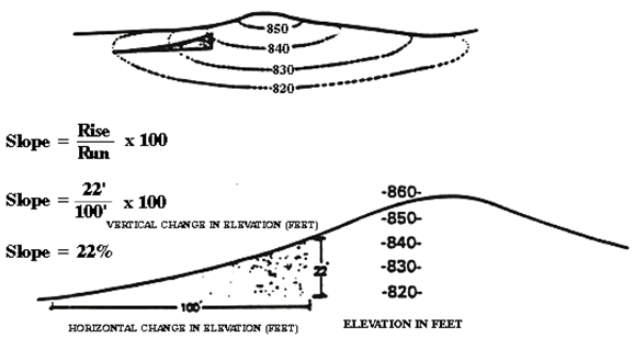
Figure 9.71.060-A Measurement of Slope
C.
Additional Application Materials for Specific Plans. Specific plan applications for areas that include hillside areas shall include the following additional application materials:
1.
A preliminary grading plan showing structure footprints;
2.
A narrative describing the setting of the site and the slopes;
3.
Cross-sections and line-of-site analyses;
4.
Color photos showing any rock outcroppings, natural water courses, vegetation and other natural features;
5.
Also, the site shall be surveyed and staked for field reference.
D.
Ridgeline Development. Development is not permitted along visually prominent ridgelines within the Town in order to preserve the existing backdrop to the community and to maintain the open character of such ridgelines in and around Apple Valley. For purposes of this Chapter "Visually Prominent Ridgelines" is defined as those ridgelines visible from the valley floor or from major thoroughfares in and around the Town.
E.
Existing Lots. If, prior to the adoption of this Chapter, parcels were legally subdivided into lots smaller than those permitted in Section 9.56.060.H.2 of this Code, an owner may construct one residential unit on said lot. In that situation, this Chapter shall be used to assist in locating the least environmentally destructive and most aesthetically appropriate building pad site.
F.
Grading Techniques. The following are the four primary types of grading that can occur on a site:
1.
Split Pad Grading. This type of grading reduces the massiveness of both the earth cuts and the architectural design. Structures should be limited to one story. Site designs should adhere to the natural contours and site conditions as shown in Figure 9.56.060-B.

Figure 9.71.060-B Split Pad Grading
2.
Contour Grading. Contour grading avoids the imposition of artificial angles and slope cuts on hillsides. The principles of contour grading shall be applied to road cuts, large pad excavation and fill, and detention/retention basins as shown in Figures 9.56.060-C and D.
3.
Natural Grading. Natural grading selectively creates pads where natural opportunities exist, soil conditions and groundwater courses are respected to a maximum degree. Natural vegetation is preserved and desert washes and ridgelines are left in a natural condition as shown in Figure 9.56.060-E.
4.
Conventional Mass Grading. Conventional grading generally alters the natural landscape severely; native vegetation is lost, biotic communities are displaced, natural slopes are altered or replaced, and erosion potentials increase. Therefore, conventional mass grading is not permitted in hillside areas.
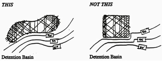
Figure 9.71.060-C Contour Grading
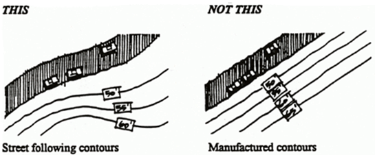
Figure 9.71.060-D Contour Grading
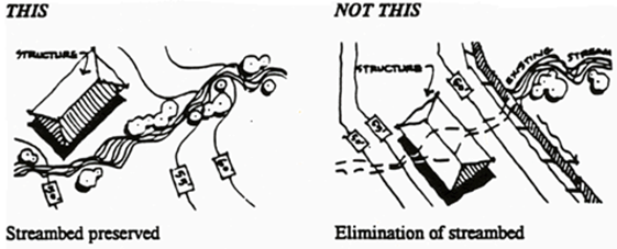
Figure 9.71.060-E Natural Grading
G.
Erosion Control. Grading plans for hillside areas shall include temporary and permanent erosion control plans. Temporary methods shall include, but are not limited to:
1.
Sandbagging;
2.
Use of watering trucks at specified intervals;
3.
Hydroseeding;
4.
Application of soil stabilizers.
Permanent erosion control methods shall include, but are not limited to:
1.
Minimal alteration of landforms and vegetation;
2.
Revegetation of slopes denuded of natural vegetation;
3.
Installation of irrigation systems appropriate for the desert environment.
H.
Hillside Slope Zones
1.
Types of Hillsides
2.
Maximum Permitted Residential Densities [13]
I.
Slope Zone Development
1.
Minor Slopes - 15% to 20%
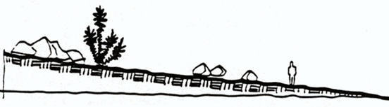
Figure 9.71.060-F Minor Slopes - 15% to 20%
a.
Heights. Heights should be limited to twenty-five (25) feet from grade and subterranean garages and rooms are encouraged. Pads should be split to reduce the impact of manufacturing a larger, traditional pad.
b.
Open Space Development Standards. Development shall retain the following minimum amount of undisturbed native open space.
Minor Slopes: 55%
Major Slopes: 60%
Removal of native vegetation shall require review and approval of a Grading Plan or Native Vegetation Removal Plan and a Revegetation Plan by the Building and Safety Division.
c.
Development standards. The maximum permitted density is one (1) unit per acre and at least fifty (50) percent of the lot shall be left undisturbed. Existing native vegetation may be removed upon the submittal to and approval by the Building and Safety Division of a removal plan.
d.
Fencing
1)
Residential. Closed privacy fencing shall be limited to the immediate area around the home or outbuildings, utilize large courtyard areas to provide private outdoor space. The balance of the lot shall remain open or fenced with open type fencing material.
2)
Commercial. Fencing at commercial development shall be limited to that needed for screening or security purposes.
e.
Flag lots. Flag lots are permitted if the terrain is such that developable land can only be accessed in that manner. Flag lots are limited to areas constrained by topography and the need to preserve natural features and are not permitted simply to maximize unit count.
f.
Garages and driveway approaches. Garages may be attached or detached. Driveway approaches shall be contoured to the natural terrain.
g.
Lot Dimensions. Minimum average lot widths for one (1) acre lots in this slope category shall be one hundred fifty (150) feet. Lots shall be designed to incorporate logical, landform related boundaries such as hill tops, ravines or washes.
h.
Setbacks. Building setbacks, in this slope category, for any structure requiring a building permit, are:
i.
Commercial developments. Commercial developments in minor slope areas shall be limited to those uses that are accessory uses, such as restaurants, pro shops, etc.
j.
Industrial developments. Industrial developments are not permitted in hillside areas, except as may be otherwise permitted in this Development Code, e.g., mining.
2.
Major Slopes - 20.1% to 30%
a.
Heights. Heights should be limited to twenty-five (25) feet from grade and subterranean garages and rooms are encouraged. Pads should be split to reduce the impact of manufacturing a larger, traditional pad.
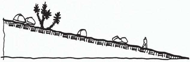
Figure 9.71.060-G Major Slopes - 20.1% to 30%
b.
Form. The form of the structure shall follow the landform in terms of scale, roof line, projections and bulk. Split pad grading is strongly encouraged.
c.
Development standards. The maximum permitted density is one (1) unit per five (5) acres and at least sixty-five (65) percent of the lot shall be left undisturbed. Existing native vegetation may be removed upon the submittal to and approval by the Building and Safety Division of a removal plan.
d.
Fencing
1)
Residential. Closed privacy fencing shall be limited to the immediate area around the home or outbuildings, utilize large courtyard areas to provide private outdoor space. The balance of the lot shall remain open or fenced with open type fencing material.
2)
Commercial. Fencing at commercial development shall be limited to that needed for screening or security purposes.
e.
Garages and driveway approaches. Driveway approaches shall be contoured to the natural terrain and shall approach the home in the most sensitive manner possible.
f.
Grading. Preliminary grading plans shall show all contours, rock outcroppings and access. Permitted grading techniques include:
1)
Split pad grading
2)
Natural grading
3)
Contour grading
g.
Lot Dimensions. Minimum average lot widths for five (5) acre lots shall be three hundred (300) feet. Lots shall be designed to incorporate logical, landform related boundaries such as hill tops, ravines or washes.
h.
Setbacks. In this slope category, the minimum building setback for any structure requiring a building permit is fifty (50) feet, this includes all setbacks, front, street side, side and rear.
i.
Commercial developments. Commercial developments in major slope areas shall be limited to those uses that are accessory uses, such as restaurants, pro shops, etc., to resort developments.
j.
Industrial developments. Industrial developments are not permitted in hillside areas, except as may be otherwise permitted in this Development Code, e.g., mining.
3.
Steep Slopes - 30.1% or Greater
a.
Heights. Heights should be limited to twenty-five (25) feet from grade and subterranean garages and rooms are encouraged. Pads should be split to reduce the impact of manufacturing a larger, traditional pad.
b.
Form. The form of the structure shall follow the landform in terms of scale, roof line, projections and bulk. Split pad grading is strongly encouraged.
c.
Development standards. The maximum permitted density is one (1) unit per twenty (20) acres and at least eighty-five (85) percent of the lot shall be left undisturbed. Existing native vegetation may be removed upon the submittal to and approval by the Building and Safety Division of a removal plan.
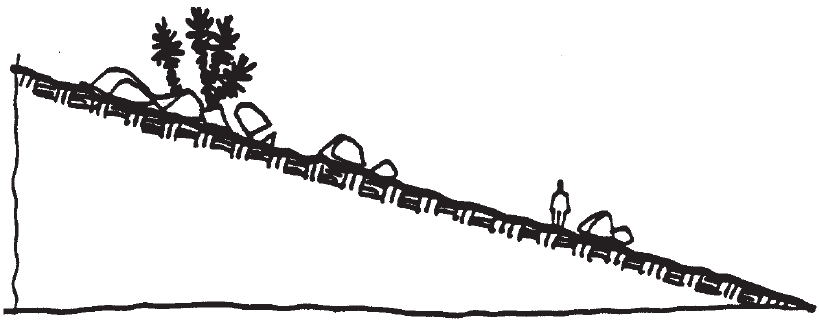
Figure 9.71.060-H Steep Slopes - 30.1% or Greater
d.
Fencing
1)
Residential. Closed privacy fencing shall be limited to the immediate area around the home or outbuildings, utilize large courtyard areas to provide private outdoor space. The balance of the lot shall remain open or fenced with open type fencing material.
e.
Garages and driveway approaches. Garages may be attached if the increased mass does not negatively impact views. Driveway approaches shall be contoured to the natural terrain and shall approach the home in the most sensitive and inconspicuous manner possible.
f.
Grading. Preliminary grading plans shall show all contours, rock outcroppings and access. Permitted grading techniques include:
1)
Split pad grading
2)
Natural grading
3)
Contour grading
g.
Lot Dimensions. Lot widths in this slope category shall be based on landform and topography, not minimum linear footages. Lots shall be designed to incorporate logical, landform related boundaries such as hilltops, ravines or washes.
h.
Setbacks. In this slope category, the minimum building setback for any structure requiring a building permit is fifty (50) feet, this includes all setbacks, front, street side, side and rear.
i.
Commercial developments. Commercial developments are not permitted in this slope category.
j.
Industrial developments. Industrial developments are not permitted in hillside areas, except as may be otherwise permitted in this Development Code, e.g., mining.
C.
Special Design Criteria
1.
Lot Area and Width. Lot area and width shall be closely related to the terrain, drainage, percolation factors or the construction of sewers, with special emphasis on the selection of homesites and the access to the homesites.
2.
Roadway Grades. Roadway grades shall not exceed twelve (12) percent unless written clearance is given by the Apple Valley Fire Protection District and the Town Engineer.
3.
Improvements. Improvements shall be in accordance with Town Standards unless otherwise approved in writing by the Town Engineer. The location and installation of utilities shall minimize disturbance of the natural terrain and shall not be within designated natural areas (open space areas).
4.
Driveways. All driveways shall be a minimum of twelve (12) feet in width with a maximum grade of twenty (20) percent and surfaced to Town standards.
5.
Cut and Fill Slopes. All roadway related cut and fill slopes shall be within the roadway right-of-way or within easements; slope maintenance easements may be required.
D.
Required Findings for Approval. No hillside subdivision shall be approved unless the Planning Commission or other reviewing authority makes all of the following findings:
1.
The natural topographic features of the hills and knolls surrounding the Town have been respected and protected. Significant natural landmarks and other outstanding features such as rock outcroppings have been retained in their natural state.
2.
All development within the subdivision has been kept from natural slope areas of fifteen (15) percent or greater except as specifically authorized by the Town of Apple Valley Development Code.
3.
The overall density or intensity of land usage in all land use districts within the subdivision generally decrease as the slope increases.
4.
The views of the hills and knolls from the valley floor and the viewshed from the hills and knolls to the surrounding area has been adequately respected and maintained.
5.
Grading has been kept to an absolute minimum in order to maintain the natural character of the hillsides. Unavoidable grading complements natural land forms and natural drainage courses have been preserved.
6.
Mass grading of large pads and excessive terracing has been avoided in residential developments and minimized in commercial and industrial developments.
7.
Proposed development plans have utilized varying setbacks and heights for buildings, building techniques, building forms and materials which adequately ensure the compatibility of structures with the surrounding terrain.
8.
The street and circulation design respects the natural contours of the land, minimizes grading requirements and minimizes the percentage of land devoted to streets.
9.
Altered slopes will be re-landscaped with plants that are compatible with the project's soils, terrain and micro-climate, reduce the risk of fire, and are compatible with requirements for water conservation.
(1) Resort units are permitted at the same densities.
9.71.080 - Lot Splits
A.
Purpose. This Section is intended to allow the property owner to split a lot into two (2) parcels when the circumstances and conditions surrounding the lot indicate that a lot split will not be detrimental to adjacent properties and is in conformance to the conditions listed below. This Section is not intended to circumvent the Subdivision Map Act; therefore, any subsequent division of the resulting lots will require the processing of Tentative and Final Parcel or Tract Maps.
B.
Conditions. In accordance with paragraph 9.71.010.E.6 of this Chapter, lots may be split into two (2) parcels without the requirement for a Tentative or Final Parcel Map when all of the following conditions are satisfied:
1.
The resulting lots are in conformance with the Development Code, General Plan, the Subdivision Map Act and all other applicable regulations not specifically modified by this Section.
2.
The size of the resulting lots is in conformance with the zoning district in which the subject property is located. The provisions of this Section do not apply if rezoning is required or requested.
3.
All improvements including, but not limited to, streets, approved water supply, approved sewage disposal facilities, other utilities, drainage control, easements and environmental protection are existing to serve the resulting lots and no further improvements are required.
4.
Exception: A lot split, under this Section, can be accomplished if all the following apply:
a.
The lot, prior to the lot split, would need to be a minimum of two (2) gross acres or more in lot size, and not more than ten (10) gross acres. However, the Director shall have the discretion to approve a lot split on a property of ten (10) gross acres or more if it can be determined that a subdivision as envisioned in the General Plan cannot be feasibly constructed on the lot due to significant infrastructure constraints.
b.
The lot would need to be zoned residential or agricultural, and located east of Navajo Road or south of Bear Valley Road. These regulations do not apply to properties zoned Very Low Density Residential (R-VLD), also known as the Apple Valley Dry Lake. The lot shall not be on a road designated on the Circulation Map, also called Street System Map (Exhibit 11-6) of the General Plan.
c.
The lot would need to front on to an existing dirt road, which the road is physically existing and graded at least twelve (12) feet wide as of the date of this Ordinance, and the road is legally dedicated or can be dedicated as part of, or in conjunction with the lot split. The lot split would need to demonstrate legal access to the Town's nearest maintained road; and
d.
Both physical and legal access must be approved by the Apple Valley Fire District or conditioned to comply with the district's requirements prior to recordation of the lot split.
e.
The property is not within two hundred (200) feet of sewer.
f.
The lot has not been established through prior exercise of a lot split as. provided for in this section.
C.
Procedures
1.
Submittal. The submittal shall include a formal application with all required supporting materials and fees.
2.
Staff Review. The request for a Lot Split will be reviewed by staff to determine its applicability to this Section. A determination will be made and the applicant notified in writing within thirty (30) days of submittal.
3.
Determination. If it is determined that the requested Lot Split conforms to the provisions of this Section, a Certificate of Compliance shall be filed with the County Recorder within thirty (30) days of such determination.
D.
Requirements
1.
Items to be Submitted with Lot Splits.
a.
Completed application form.
b.
Ownership Certification.
c.
Five (5) copies of the Site Plan.
2.
Information to be Included on Site Plans.
a.
List the names, addresses and telephone numbers of the owners of record.
b.
List the names, addresses and telephone numbers of all utility companies which will serve the resulting lots including, but not limited to, water supply, sewage disposal, telephone, cable, electrical and natural gas.
c.
Clearly show the north arrow (directed toward the top of the map), the scale of the site plan, the boundary lines and dimensions of the project and the date of preparation of the site plan.
d.
List the Assessor's Parcel Number(s).
e.
Provide a legal description of the land included within the proposed lot split.
f.
List the total acreage and the acreage of the resulting lots.
g.
Show the zoning district classification and land use or uses of the adjoining property within one hundred (100) feet of the proposed lot split.
h.
List by note the required building setbacks.
i.
Show the locations, names and existing rights-of-way of all adjoining highways, streets, alleys and/or ways, roads, etc. If none exist, show access to the property.
j.
Show the width and location of all recorded and/or proposed easements, dedication of streets or rights-of-way.
k.
Show the location, width and direction of flow of all water courses.
l.
Show the location and outline, to scale, of each structure on the subject property and list their existing and proposed use.
(Ord. No. 562, § 4, 2-14-2023)
9.71.090 - Reversions to Acreage
This Section establishes procedures for processing requests for reversions to acreage in accordance with Chapter 6, Article 1 of the Subdivision Map Act. Requests for reversions to acreage shall be reviewed and acted upon by the Planning Commission. Appeals may be made pursuant to the provisions of this Chapter.
A.
Initiation of Proceedings (66499.12). Proceedings for reversions to acreage map may be initiated by either of the following:
1.
By Owner(s). A petition of all the owners of record in the form prescribed by and containing the information required by this Section and the Subdivision Map Act.
2.
By Town Council. A resolution of the Town Council at the request of any person or on its own motion.
B.
Data Required for a Reversion to Acreage (66499.13). The following data shall be provided:
1.
Adequate evidence of title to the real property within the subdivision and one or more of the following:
a.
Evidence of the consent of all the owners of any interest in the property; or
b.
Evidence that none of the improvements required to be made have been made within two (2) years from the date the Final Map was recorded, or within the time allowed by the Improvement Agreement, whichever is later; or
c.
Evidence that no lots shown on the Final Map have been sold within five (5) years from the date the Final Map was recorded.
2.
A Final Map shall be provided with the petition, prepared in accordance with this Chapter, which delineates the dedications which are not proposed to be vacated, as well as any dedications which are required as a condition to the proposed reversion to acreage.
C.
Fees (66499.14). All petitions for reversion to acreage shall be accompanied by the applicable fees for processing, such fees are nonrefundable. Fees for a reversion to acreage through resolution of the Town Council shall be paid by the person requesting such resolution.
D.
Required findings for approval (66499.16). Subdivided real property may be reverted to acreage only if the Planning Commission finds that:
1.
Dedications or offers of dedication to be vacated or abandoned by the reversion to acreage are unnecessary for present or prospective public purposes; and
2.
Either:
a.
All owners of an interest in the real property within the subdivision have consented to reversion; or
b.
None of the improvements required to be made have been made within two (2) years from the date the Final or Parcel Map was filed for record, or within the time allowed by agreement for completion of the improvements, whichever is the later; or
c.
No lots shown on the Final or Parcel Map have been sold within five (5) years from the date such map was filed for record.
E.
Required Conditions of Approval (66499.17). As conditions of reversion to acreage the Planning Commission shall require:
1.
Dedications or offers of dedication necessary for the public purposes specified in the General Plan, Development Code or other applicable ordinance.
2.
Retention of all previously paid fees if necessary to accomplish the purpose of this Chapter.
3.
Retention of any portion of required improvement security or deposits if necessary to accomplish the purpose of this Chapter.
F.
Filing Reversion Map with County Recorder. The proposed reversion to acreage shall be effective upon the recording of the Final Map by the County Recorder.
G.
Return of Fees, Deposits; Release of Securities (66499.19). When a reversion to acreage is effective, all fees and deposits shall be returned and all improvement security released, except those retained in accordance with subsection 9.71.090.E above.
9.71.100 - Parcel Mergers
A.
Merger and Re-Subdivision (66499.201/2). Subdivided lands may be merged and re-subdivided without reverting to acreage by complying with all the applicable requirements for the subdivision of land as provided by this Chapter pursuant to the Subdivision Map Act. Any unused fees or deposits previously made pursuant to this Chapter pertaining to the property shall be credited pro rata towards any of the requirements for the same purposes which are applicable at the time of re-subdivision. Any streets or easements to be left in effect after the re-subdivision shall be delineated on the map. After approval the map shall be delivered to the County Recorder for recording. The filing of the Final Map shall constitute legal merging of the separate parcels into one parcel and the re-subdivision of such parcel and shall also constitute abandonment of all streets and easements not shown on the map.
B.
Requirements for Parcel Merger (66451.10 et seq. and 66499.203/4). This section establishes specific criteria for parcel mergers when initiated by the Town of Apple Valley or when voluntarily requested by the current owner of record of the affected property.
1.
Two or more contiguous parcels or units of land held by the same owner shall be considered merged if one of the parcels or units of land does not conform to the minimum parcel or lot size required by the zoning district classification of the Town of Apple Valley, and if all of the following requirements are satisfied:
a.
At least one of the affected parcels is:
1)
Not developed with any structure for which a building permit was issued or for which a building permit was not required at the time of construction; or
2)
Developed with only an accessory structure(s); or
3)
Developed with a single structure, other than an accessory structure, that is also partially sited on a contiguous parcel or unit of land.
b.
With respect to any affected parcel, one or more of the following conditions exist:
1)
Comprises less than five thousand (5,000) square feet in area at the time of the determination of merger.
2)
Was not created in compliance with applicable laws and ordinances in effect at the time of its creation.
3)
Does not meet current standards for sewage disposal and domestic water supply.
4)
Does not meet slope stability standards.
5)
Has no legal access which is adequate for vehicular and safety equipment access and maneuverability.
6)
Its development would create health or safety hazards.
7)
Is inconsistent with the General Plan and any applicable specific plan, other than minimum lot size or density standards.
c.
For purposes of determining whether contiguous parcels are held by the same owner, ownership shall be determined as of the date that the Notice of Intention to Determine Status is recorded.
d.
The conditions stated in paragraph 9.71.100.B.1.b shall not apply if one of the following conditions exist:
1)
On or before July 1, 1981, one or more of the contiguous parcels or units of land is enforceably restricted open-space land pursuant to a contract, agreement, scenic restriction, or open-space easement, as defined and set forth in Section 421 of the Revenue and Taxation Code.
2)
On July 1, 1981, one or more of the contiguous parcels or units of land is timberland as defined in subsection (f) of Section 51104, or is land devoted to an agricultural use as defined in subdivision (b) of Section 51201.
3)
On July 1, 1981, one or more of the contiguous parcels or units of land is located within 2,000 feet of the site on which an existing commercial mineral resource extraction use is being made, whether or not the extraction is being made pursuant to a use permit issued by the Town of Apple Valley.
4)
On July 1, 1981, one or more of the contiguous parcels or units of land is located within 2,000 feet of a future commercial mineral extraction site as shown on a plan for which a use permit or other permit authorizing commercial mineral resource extraction has been issued by the Town of Apple Valley.
C.
Town Initiated Parcel Merger. The Town of Apple Valley may initiate the merger of substandard parcels or units of land provided such parcels or units meet the requirements for parcel merger, as specified in paragraph 9.71.100.B.1 of this Chapter. All Town Initiated parcel mergers shall comply with the following procedures for determining parcel status, holding and requesting public hearings, and recording Notices of Merger or Clearances.
1.
Notice of Intention To Determine Status. Prior to recording a Notice of Merger, the Director shall mail, by certified mail, a Notice of Intention to Determine Status to the Current record owner of the property. The notice shall state that the affected parcels may be merged pursuant to this section and that, within thirty (30) days from the date the Notice of Intention was recorded, the owner may request a hearing before the Planning Commission to present evidence that the property does not meet the criteria for merger. The Notice of Intention to Determine Status shall be filed for record at the Office of the San Bernardino County Recorder on the same day that the notice is mailed to the property owner.
2.
Effective Date of Mergers. A merger of parcels shall become effective when the Director causes to filed for record with the Office of the San Bernardino County Recorder, a Notice of Merger specifying the names of the record owners and particularly describing the real property.
3.
Hearing on Determination of Status. The owner of the affected property may file a written request for a hearing with the Planning Commission within thirty (30) days after recording the Notice of Intention to Determine Status. Upon receipt of the request for hearing, the Director shall set a time, date and place for a hearing before the Planning Commission and shall notify the property owner by certified mail. The hearing shall be conducted within sixty (60) days following receipt of the property owner's request for hearing, or may be postponed or continued with the mutual consent of the Planning Commission and the property owner.
At the hearing, the property owner shall be given the opportunity to present any evidence that the affected property does not meet the requirements for merger as specified in Section 9.71.100.B.1.
Upon conclusion of the hearing, the Planning Commission shall determine whether the affected parcels are to be merged or are not to be merged and shall notify the owner of the determination. A determination of nonmerger may be made whether or not the affected property meets the requirements for merger as specified in Section 9.71.100.A.1, if for any reason, the Planning Commission determines that the property is inappropriate for merger. The notification of merger or nonmerger shall be mailed to the property owner within five (5) days of the date of the hearing.
4.
Planning Commission Determination of Merger. If the Planning Commission makes a determination that the parcels or units of land are to be merged, a Notice of Merger shall be recorded within thirty (30) days after the hearing, unless the decision has been appealed pursuant to paragraph 9.71.100.B.6 of this Chapter. The Notice of Merger shall specify the name of the record owners and a description of the real property.
If the Planning Commission makes a determination that the parcels or units of land shall not be merged, it shall cause to be recorded, within thirty (30) days, a release of the Notice of Intention to Determine Status with the Office of the San Bernardino County Recorder and shall mail a clearance letter to the current owner of record.
5.
Appeal of Determination. The determination of the Planning Commission may be appealed to the Town Council by filing a written Notice of Appeal within ten (10) calendar days of the date of mailing the Notice of Intention to Determine Status. The Town Council shall hear the appeal within sixty (60) days from the date of appeal. If, after the hearing, the Town Council grants the appeal and determines that the affected property has not been merged pursuant to this section, the Town Clerk shall, within thirty (30) days, record a release of the Notice of Intention to Determine Status with the Office of the San Bernardino County Recorder and shall mail a clearance letter to the current owner of record.
6.
Determination when no Hearing is Requested. If, within thirty (30) days, the owner does not file a request for a hearing, the Director may, at any time thereafter, make a determination that the affected parcels are to be merged or are not to be merged. If the parcels are to be merged, a determination of merger shall be recorded within ninety (90) days of the mailing of the Notice of Intent to Determine Status.
D.
Request to Merge by Property Owner. The property owner(s) may voluntarily request the merger of substandard parcels or units of land provided such parcels or units meet the requirements for parcel merger, as specified in paragraph 9.71.100.B.1 of this Chapter. Unless specifically modified by this section, all procedures defined under paragraph 9.71.100.C.1 of this Chapter shall also apply to property owner requested parcel mergers.
1.
Waiver of Hearing. If the merger of contiguous parcels or units of land is voluntarily requested by the record owner(s), the owner(s) may waive the right to a hearing before the Planning Commission and to all notices required by this section. Upon signing the waiver, the Director shall record a Notice of Intention to Determine Status, a waiver of right of hearing and notice, and a Notice of Merger simultaneously.
9.71.110 - Parcel Unmergers
A.
Requirements for Unmerger. This section establishes the specific criteria under which a parcel or unit of land may be deemed unmerged.
1.
Any parcel or unit of land for which a Notice of Merger has not been recorded on or before January 1, 1984, shall be deemed not to have merged if on January 1, 1984:
a.
The parcel meets each of the following criteria:
1)
Comprises at least 5,000 square feet in area.
2)
Was created in compliance with applicable laws and ordinances in effect at the time of its creation.
3)
Meets current standards for sewage disposal and domestic water supply.
4)
Meets slope density standards.
5)
Has legal access which is adequate for vehicular and safety equipment access and maneuverability.
6)
Development of the parcel would create no health or safety hazards.
7)
The parcel would be consistent with the General Plan and any applicable specific plan, other than minimum lot size or density standards.
b.
And, with respect to such parcel, none of the following conditions exist:
1)
On or before July 1, 1981, one or more of the contiguous parcels or units of land is enforceably restricted open-space land pursuant to a contract, agreement, scenic restriction, or open-space easement, as defined and set forth in Section 421 of the Revenue and Taxation Code.
2)
On July 1, 1981, one or more of the contiguous parcels or units of land is timberland as defined in subsection (f) of Section 51104, or is land devoted to an agricultural use as defined in subdivision (b) of Section 51201.
3)
On July 1, 1981, one or more of the contiguous parcels or units of land is located within 2,000 feet of the site on which an existing commercial mineral resource extraction use is being made, whether or not the extraction is being made pursuant to a use permit issued by the Town of Apple Valley.
4)
On July 1, 1981, one or more of the contiguous parcels or units of land is located within 2,000 feet of a future commercial mineral extraction site as shown on a plan for which a use permit or other permit authorizing commercial mineral resource extraction has been issued by the Town of Apple Valley.
B.
Request for Determination by Property Owner. Upon written application made by the property owner, the Director shall make a determination that the affected parcels or units of land have merged or, if meeting the requirements of unmerger, are deemed not to have merged.
1.
Notification of Unmerger. Upon determination by the Director that the parcels or units of land meet the requirements for unmerger, the Director shall issue to the owner and record with the Office of the San Bernardino County Recorder, a notice of the status of the parcel which shall identify each parcel and declare that the parcels or units of land are unmerged pursuant to Article 1.7 of the Subdivision Map Act.
2.
Notification of Merger. Upon determination by the Director that the parcels or units of land have merged and do not meet the requirements for unmerger, the Director shall issue to the owner and record with the Office of the San Bernardino County Recorder, a Notice of Merger, in conformance with Section 9.71.100 of this Chapter.
9.71.120 - Lot Line Adjustments
A.
General (66412.d). Lot line adjustments modify the boundary line between two or more adjacent legal parcels where the modification complies with the following:
1.
The land taken from one parcel is added to an adjacent parcel, and where a greater number of parcels than originally existed is not thereby created.
2.
The modified parcels are consistent with or more closely compatible with the minimum lot size and area requirements of this Development Code, the Town General Plan and any applicable Specific Plan.
3.
The modified lot lines do not alter an existing right-of-way, except with written approval of the Town Engineer.
B.
Purpose. Lot line adjustments are the relocation of existing property lines for any of the following purposes:
1.
To eliminate an existing encroachment; or
2.
To meet or more closely meet the minimum lot size and area requirements of the zoning district classification in which the subject property is located; or
3.
To meet building setback requirements; or
4.
To better recognize topographic features; or
5.
Other purposes approved by the Director.
C.
Filing Requirements
1.
Application Submittal Requirements. Applications for Lot Line Adjustments shall be filed with the Planning Division on a form prescribed by the Director and shall contain such information and reports as may be required by the application submittal package or by other applicable ordinances or by the Director in order to make the required findings.
2.
Application Fee. The application shall be accompanied by a fee established by resolution of the Town Council to cover the cost of handling and processing the application as prescribed in this Code.
D.
Procedures. Applications for Lot Line Adjustments shall be made to the Director on forms provided by the Planning Division and shall be accompanied by other required materials and applicable fees.
1.
The Director shall notify the applicant within thirty (30) days of receipt of the application, that the request does or does not meet the requirements for a Lot Line Adjustment.
2.
The Director shall, within thirty (30) days of the application being accepted as complete, approve, conditionally approve or disapprove the request and so notify the applicant in writing. Director approval shall constitute the projects compliance with this Development Code, the Town General Plan, building ordinances and any applicable Specific Plan.
3.
Following the Director's approval, the applicant shall submit a Certificate of Compliance for each modified parcel. The Certificate of Compliance shall describe the new parcel boundaries as approved by the Director and shall be prepared by a licensed land surveyor or professional engineer qualified to prepare such documents. The original Certificate of Compliance shall be submitted to the Town (along with the appropriate review fees) for review and approval by the Town Engineer. Any Certificate of Compliance for parcels that are tax delinquent shall not record.
4.
Lot line adjustments shall be reflected in a recorded deed within ninety (90) days after recordation of the Certificate of Compliance, or the lot line adjustment shall be void.
9.71.130 - Correction and Amendment of Maps
A.
Tentative Maps. Minor corrections or amendments to approved Tentative Maps or Conditions of Approval may be granted by the Director provided that all of the following are true:
1.
No lots, units or building sites are added or deleted; and
2.
The proposed changes are consistent with the original Tentative Map intended findings, approval and condition of approval; and
3.
The proposed changes are consistent with the Development Code, the General Plan and the Subdivision Map Act.
Approval of minor corrections or amendments shall not change any expiration dates. Corrections and amendments to Tentative Maps and Conditions of Approval which are not deemed by the Director to be minor shall be reviewed at public hearing by the Planning Commission upon submittal of the appropriate application, materials and fees by the subdivider.
Changes that add or delete any number of lots shall require a new Tentative Map application.
B.
Final Maps
1.
Correction (66469). After a Final or Parcel Map is filed in the office of the County Recorder, the recorded Final Map may be modified by a Certificate of Correction or an Amending Map in order to:
a.
Correct an error in any course or distance shown; or
b.
Show any course or distance that was previously omitted; or
c.
Correct an error in the description of the real property shown on the map; or
d.
Indicate monuments set after the death, disability or retirement from practice of the engineer or surveyor charged with responsibilities for setting monuments; or
e.
Show the proper location or character of any monument which originally was shown at the wrong location or incorrectly as to its character; or
f.
Correct any other type of map error or omission as approved by the County Surveyor or the Town Engineer which does not affect any property right. Such errors and omissions may include, but are not limited to, lot numbers, acreage, street names, and the identification of adjacent record maps.
As used in this Section, "error" does not include changes in courses or distances from which an error is not ascertainable from the data shown on the Final Parcel or Tract Map.
2.
Form and Content. The Amending Map or Certificate of Correction shall be prepared and signed by a registered civil engineer or licensed land surveyor. An Amending Map shall conform to the requirements of Section 9.71.050 of this Chapter. The Amending Map or Certificate of Correction shall set forth in detail the corrections made and the names of the present fee owners of the property affected by the corrections.
3.
Submittal and Certification
a.
Submittal. The application for an Amending Map or Certificate of Correction shall be submitted to the Town Engineer upon payment of appropriate fees and on forms provided by the Town Engineer.
b.
Certification. The Town Engineer shall examine the Amending Map or Certificate of Correction and if the only changes made are those set forth in paragraph 9.71.120.B.1 above, he shall certify to this fact on the Amending Map or Certificate of Correction. Such certification shall not change any expiration dates.
4.
Filing with County Recorder. After the Amending Map or Certificate of Correction has been certified by the Town Engineer, it shall be filed in the office of the County Recorder.
5.
Amendment (66472.1). In addition to the corrections authorized by paragraph 9.71.120.B.1 above, the recorded Final or Parcel Map may be modified by an Amendment of Final Map.
a.
Application. The subdivider may apply for an Amendment of Final Map upon submittal of the appropriate application, materials and fees to the Town Engineer.
b.
Standards. No Amendment of Final Map shall be approved unless it complies with all of the following standards:
1)
There are changes in circumstances which make any or all of the conditions of the Final Map no longer appropriate or necessary; and
2)
The modifications do not impose any additional burden on the present fee owners of the property; and
3)
The modifications do not alter any right, title, or interest in the real property reflected on the recorded map; and
4)
The Town Engineer finds that the map, as modified, conforms to the provisions of this Chapter, the General Plan and the Subdivision Map Act.
c.
Notice of hearing. The Town Engineer shall set the matter for public hearing in accordance with paragraph 9.71.050.A.1 of this Chapter. The hearing shall be confined to consideration of and action on the proposed modifications. Approval of the proposed modifications shall not change any expiration dates.
9.71.140 - Dedication and Improvement Regulations
A.
Dedication Requirements (66475 et seq). The subdivider, as a condition of approval of a Tentative Map, shall dedicate, or make an irrevocable offer of dedication of, all parcels of land within the subdivision that are needed for streets and alleys, including access rights and abutter's rights, drainage, public open space, trails, scenic easements, public utility easements and other public easements, in accordance with the Subdivision Map Act, the General Plan and adopted standards
All dedications to the Town for public purposes shall be made in fee title unless otherwise determined by the Town; at the Town's discretion, a grant of an easement may be accepted for open space, scenic, trails, parks, public utility easements or other interests as may be determined by the Town. All dedications and grants in fee of easements shall be free of liens and encumbrances except those which the Town finds would not conflict with the intended use. The Town may accept an irrevocable offer of dedication in place of dedication when appropriate.
1.
Waiver of Direct Access Rights (66476). Dedications or offers of dedications of streets may include a waiver of direct access rights to any such street from any property shown on the Final Map as abutting the street. If the dedication is accepted, any provision for waiver of direct access rights shall become effective in accordance with its provisions.
2.
Reservations (66479 and 66480). Subject to and in accordance with applicable provisions of law, including the Subdivision Map Act, the subdivider, as a condition of approval of a Tentative Map, may be required to dedicate areas of real property for parks, recreational facilities, fire stations, libraries or other public uses.
3.
School Site Reservations (66478). Subject to and in accordance with applicable provisions of law, including the Subdivision Map Act, the subdivider, as a condition of approval of a Tentative Map, may be required to dedicate real property for the construction of an elementary school to assure the residents of the subdivision adequate public school service.
B.
Improvement Regulations
1.
The following are improvement requirements for Parcel Maps for detached single family projects.
a.
Parcel maps which subdivide lots to the ultimate level of subdivision or size that is within the range of minimum lot sizes permitted in the land use designation:
1)
One point of paved access to an existing paved road and interior street paving shall be required as a condition of Final Map approval for Parcel Map projects when any of the resulting parcels are less than 2.5 gross acres in size.
2)
Paved access to an existing paved road and interior street paving shall not be required as a condition of Final Map approval for Parcel Map projects when all of the resulting parcels are equal to or greater than two and one-half (2 1/2) gross acres in size and if the developer complies with either a), b) or c), below as approved by the Town Engineer:
a)
An in-lieu fee as approved by the Town Engineer is paid to the Town of Apple Valley; or
b)
The owner of the property being developed executes an agreement with the Town not to protest the formation of an assessment district created for the purpose of constructing paved roads; or
c)
The property being developed is within the boundaries of an assessment district created for the purpose of paving the local roads which will provide direct access to the site being developed.
b.
Parcel Maps which subdivide the land into parcels larger than the range of minimum lot sizes permitted in the land use designation shall be required to install improvements as a condition of Final Map approval, however, these may be deferred pursuant to paragraph 9.71.140.B.2 below.
2.
The following are improvement requirements for other parcel maps.
Street improvements for commercial, industrial and/or multi-family developments, or Parcel Maps which are used as a financing vehicle for new development or described in paragraph 9.71.140.B.1.b above, may be deferred and/or phased by the Planning Commission on a case-by-case basis subject to the criteria below. Improvements for such projects shall be required when a building permit is issued.
a.
Parcel Maps which are used as a financing vehicle shall be defined for purposes of this Section as a Parcel Map which is processed in conjunction with or subsequent to another type of land use approval (i.e., subdivision, site plan review, Conditional Use Permit, Planned Development, Specific Plan, etc.) under which improvements are required to be installed.
b.
In granting approval for a deferral of improvements or a partial deferral of improvements, the Planning Commission must determine that a deferral agreement is required to be executed. The Planning Commission may grant approval of deferral of improvements only when a finding can be made that individual parcels are in reasonable proximity to existing improvements and infrastructure and that the necessary improvements to serve development of the individual parcels can be feasibly provided by each individual parcel.
3.
Improvement Agreement (66462). Prior to submitting a Final Map for approval, the subdivider shall execute an improvement agreement, in a form approved by the Town Engineer and Town Attorney, specifying the time by which the required improvements will be completed. The Improvement Agreement shall be reviewed by the Town Council and if approved, executed by the Mayor. The Improvement Agreement shall be secured as provided for in paragraph 9.71.140.B.3 of this Chapter.
4.
Improvement Agreement; Time Extensions. The completion date specified in the Improvement Agreement or as specified in paragraph 9.71.140.B.4 below, may be extended by the Town Council for subdivisions of five (5) or more parcels and by the Town Engineer for subdivisions of four (4) or less parcels upon a written request by the subdivider. The request for said time extensions, along with the appropriate application, materials and fees, shall be submitted at least thirty (30) days prior to the expiration of the Improvement Agreement or the time specified in paragraph 9.71.140.B.4 below.
5.
Improvement Security (66499 et seq). Improvement securities are required to be submitted as a guarantee of the completion of improvements required as a condition of approval of any Final Map. Acceptable forms of security, subject to approval by the Town Engineer, are limited to the following:
a.
A bond or bonds by one or more duly authorized corporate sureties;
b.
A deposit, either with the local agency or a responsible escrow agent or trust company, of money or negotiable bonds of the kind approved for securing deposits of public monies;
c.
An irrevocable instrument of credit from one or more financial institutions subject to regulation by the State or Federal Government pledging that the funds necessary to carry out the agreements are on deposit, guaranteed for payment, and constitute a trust fund which is not subject to levy or attachment by any creditor of the depositor until released by the Town.
d.
Lien Agreements in compliance with the following terms:
1)
The Subdivider/property owner ("Subdivider") may enter into an agreement with the Town to construct in the future the public portions of the subdivision improvements required by the map conditions of approval, as determined by the Town Engineer, including, but not limited to: master planned or "missing link" streets, drainage and sewer improvements, community facilities, off-site improvements, fire access, fire flow and traffic signals (hereinafter "Required Improvements") and securing such performance by granting the Town a lien on the real property to be divided. Such agreements shall be known as "Lien Agreements." The use of Lien Agreements shall only be allowed if all requirements in this subdivision B.5.d of this Section 9.71.140 are satisfied.
2)
California Government Code Section 66499(a)(4) authorizes the Town to enter into Lien Agreements if the Town Council finds that it would not be in the public interest to require the installation of the Required Improvements sooner than two (2) years after the recordation of the map.
3)
Where the Town Council finds it would not be in the public interest to require the installation of the Required Improvements sooner than two (2) years after recordation of the map, the Subdivider may execute a Lien Agreement with the Town at the time the Subdivider enters into the improvement agreement specified in Section 9.71.140.B.3 ("Subdivision Improvement Agreement") of this Chapter 9.71.
4)
At the sole discretion of the Town, a Lien Agreement may be used to substitute an existing security furnished under Section 9.71.140.B.5 for Required Improvements under a previously-executed Subdivision Improvement Agreement, if: (1) no activity for the subdivision has transpired; (2) no inspections have occurred; (3) no permits for construction of improvements have been issued within one year of the recordation of the subdivision map; and (4) upon a finding by the Town Council that it would not be in the public interest to require the installation of the Required Improvements sooner than two (2) years after the recordation of the map.
i.
The Town will not accept a Lien Agreement from any Subdivider, either at the time of execution of the Subdivision Improvement Agreement, or as a substitute for existing security, if: (1) any individual lots have been sold; (2) any construction permits, including but not limited to any grading or building permits, have been issued on any of the property; or (3) construction of any of the Required Improvements has begun.
ii.
Notwithstanding the provisions of Subdivision 140.B.5.d.4.i above, the Town may accept a Lien Agreement from a Subdivider as a substitute for an existing security if grading has commenced on the land divided, so long as the grading is in strict accordance with a valid grading permit and all the following conditions are met: (1) there is no need for the Town to construct the Required Improvements if the Subdivider's project is abandoned or delayed for any period of time; (2) the grading has no effect on the use, operation and maintenance of existing streets or highways, public or private; (3) the grading has not caused the modification or closure of any public access points, existing streets or highways, public or private; (4) additional drainage improvements and/or erosion controls are not necessary and/or installed in the road right-of-way due to the grading; (5) delay of the construction of the Subdivider's Required Improvements do not affect or delay the improvements of an adjacent Subdivider who has already commenced work on his/her Required Improvements; (6) the completion of any public improvements are not required by the Town's general plan circulation element, master plan of drainage, master sewer plan or master water plan or for any other reason for the purposes of preserving public health, safety or welfare; (7) the Subdivider provides a separate security as specified in Section 9.71.140.B.5 above, for the maintenance of the graded land, including without limitation, dust control, erosion control, fencing, and any other maintenance as required by the Town; and (8) in the case that any individual lots have been sold, at the discretion of the Town and only after the Town has performed a comprehensive review of the development (which may include approval of a construction phasing plan), completion of Required Improvements to serve the individual lots as determined by the Town Engineer and other requirements and conditions to be met prior to acceptance of the Lien Agreement.
iii.
Lien Agreements used to substitute for existing security shall be recorded against all lots that have not passed a final inspection and for which all required associated improvements, as determined by the Town Engineer, have not been completed ("Undeveloped Lots"). Such Lien Agreements shall also meet all of the requirements set forth in Sections 9.71.140.B.5.d.5 through 9.71.140.B.5.d.13 below.
5)
Lien Agreements, including those used to substitute for existing security under Section 9.71.140.B.5.d.4, above, shall:
i.
Be allowed only where the Subdivider provides a title insurance policy and title report from a title company approved by the Town documenting that: (1) the Subdivider is the record owner of the entire property to be subdivided (or in the case of a substitute security, documenting that the Subdivider is the record owner of all Undeveloped Lots) against which the Lien Agreement is to be recorded; and (2) such aforementioned property is not encumbered by any mortgages, deeds of trust, or liens. The title insurance policy and title report shall be issued forty-five (45) days prior to the execution of the Lien Agreement.
ii.
Be in a form acceptable to and approved by the Town Manager and the Town Attorney.
iii.
Be executed by the Mayor or his or her designee on behalf of the Town, and by all current record owner(s) of the property to be divided (or in the case of a substitute security, all owners of the Undeveloped Lots), as evidenced by the title insurance policy and report specified in Section 9.71.140.B.5.d.5.i, above.
iv.
Be used only to secure future improvements that would be required for any final map and/or when a Subdivider would be required by Chapter 9.71 to construct, or agree to construct, the Required Improvements for a subdivision.
v.
Contain a detailed itemization of the Required Improvements (or in the case of a substitute security, any remaining Required Improvements) and an engineer's estimate of costs to construct same, as approved by the Town Engineer, and specify that the Subdivider's obligation, and that of Subdivider's successors in interest, extends to the actual cost of construction of the aforementioned improvements if such costs exceed the estimate.
vi.
Be allowed if the Town Engineer determines the estimated costs to construct the Required Improvements (or in the case of substitute security, the remaining Required Improvements) do not exceed the fair market value of the real property against which the Lien Agreement is to be recorded, based on an appraisal conducted by an independent, licensed real estate appraiser not more than sixty (60) days prior to the date any Lien Agreement is entered. Subdivider shall furnish such appraisal to the Town at least forty-five (45) days prior to the date any Lien Agreement is entered.
vii.
Contain a legal description of the entire real property against which the Lien Agreement is being recorded as security for the Required Improvements (or in the case of substitute security, as security for the remaining Required Improvements).
viii.
Be recorded with the San Bernardino County Recorder against the entire property to be divided by the map (or in the case of substitute security, against all Undeveloped Lots). The recorded Lien Agreement shall be indexed in the Grantor index to the names of all record owners of the real property as specified on the map and/or in Section 9.71.140.B.5.d.5.i above, and in the Grantee index to the Town.
ix.
Be approved concurrently with the approval of the final map and the Subdivision Improvement Agreement executed by Subdivider, with a note of the Lien Agreement's existence placed on the map, except where the Lien Agreement is being used as substitute security after final map approval under Section 9.71.140.B.5.d.4 above, in which case the Lien Agreement shall be signed and acknowledged by all parties having any record title interest in the property against which the Lien Agreement is being recorded, as prescribed by California Government Code Section 66436, consenting to the subordination of their interests to the Lien Agreement.
x.
Require the Subdivider to pay an application fee to the Town for the processing of the Lien Agreement in an amount established and revised from time-to-time by resolution of the Town Council and included in a schedule of fees.
xi.
Be recorded concurrently with the Map.
6)
From the time of recordation of the Lien Agreement, a lien shall attach to the real property described therein and shall have the priority of a judgment lien in an amount necessary to complete the Required Improvements (or in the case of substitute security, the remaining Required Improvements) and under no circumstances shall the Town be obligated to agree to subordinate the lien.
7)
The Lien Agreement shall provide that:
i.
The Subdivider must deliver acceptable replacement security to the Town in the types and amounts specified in Sections 9.71.140.B.5.a. through 9.71.140.B.5.c. and Section 9.71.140.B.7 and approved by the Town Council in place of the Lien Agreement and commence construction of the Required Improvements and any other improvements imposed as map conditions of approval (hereinafter "Other Improvements") within three (3) years following recordation of the map; or
ii.
In the case of a substitute security, the Subdivider must deliver acceptable replacement security to the Town (in the types and amounts specified in Sections 9.71.140.B.5.a. through 9.71.140.B.5.c. and Section 9.71.140.B.7 and approved by the Town Council) in place of the Lien Agreement and commence construction of the remaining Required Improvements and Other Improvements within three (3) years following recordation of the Lien Agreement; and
iii.
Once the Lien Agreement is recorded, the Town shall not issue any development or construction permits for the property subject to the Lien Agreement until the aforementioned delivery of acceptable replacement security to the Town has occurred.
8)
The time for delivery of acceptable replacement security to the Town and commencement of construction as specified in Sections 9.71.140.B.5.d.7.i and 9.71.140.B.5.d.7.i above, may be extended once for an additional three (3) year period as approved by the Town Engineer or his designee. A Lien Agreement may therefore only be in effect for a total of six (6) years. In order to receive an extension of time under this Subsection, both of the following conditions must be met:
i.
The Subdivider shall provide a title insurance policy and title report from a title company approved by the Town documenting that: (i) the Subdivider is the record owner of the entire subdivided property against which the Lien Agreement is currently recorded as security (or in the case of a substitute security, documenting that the Subdivider is the record owner of all Undeveloped Lots against which the Lien Agreement has been recorded); and (ii) such subdivided property or Undeveloped Lots are not encumbered by any mortgages, deeds of trust, or liens. The title insurance policy and title report shall be issued forty-five (45) days prior to the date the extension of time is requested; and
ii.
The Town Engineer determines that the estimated costs for the Required Improvements (or in the case of substitute security, the remaining Required Improvements) do not exceed the fair market value of the real property against which the Lien Agreement is recorded, based on an appraisal conducted by an independent, licensed real estate appraiser not more than sixty (60) days prior to the date an extension of time is requested. Subdivider shall furnish such appraisal to the Town at least forty-five (45) days prior to the date the extension of time is requested.
9)
The Lien Agreement shall specify that no individual lots shall be sold while the Lien Agreement is in effect. However, fee title to the entire property encumbered by the Lien Agreement or to all lots designated on any individual final map which is encumbered by the Lien Agreement, may be sold in the aggregate to a single purchaser, provided that the proposed purchaser must, prior to or concurrent with assuming title to the property, either:
i.
Execute a new Lien Agreement in a form acceptable to the Town which will encumber the property to be conveyed, specifying the respective obligations of the owners of the property subject to the original and new Lien Agreement.
ii.
Deliver acceptable replacement security to the Town as set forth in Section 9.71.140.B.5.d.7 above as a condition to development of the property conveyed.
10)
The Subdivider shall also be required to provide to the Town a cash deposit per recorded subdivision tract map in an amount established and revised from time-to-time by resolution of the Town Council and included in a schedule of fees, regardless of whether the project was subdivided by a single tract map or by multiple tract map recordings through phasing, for the purpose of reverting the property to acreage if the Subdivider breaches or is in default of the terms of the Lien Agreement. Reversion to acreage and the cash deposit by reason of default or breach of the Lien Agreement shall only be applicable to properties where none of the Required Improvements for which securities were provided have been installed and/or have been constructed. Any unused portion of the cash deposit shall be refunded to the Subdivider who made such cash deposit, following completion of the reversion to acreage. If the cost of the reversion to acreage exceeds the amount deposited per recorded subdivision tract map, the Subdivider shall pay such additional costs to the Town prior to recordation of the reversion to acreage map.
11)
The Lien Agreement shall only be released: (1) upon delivery to the Town of acceptable replacement security for such Lien Agreement prior to construction and issuance of permits as set forth in Section 9.71.140.B.5.d.7 above; (2) to facilitate a sale as specified in Section 9.71.140.B.5.d.9 above; or (3) upon recordation of a reversion to acreage map.
12)
Under no circumstances shall any Lien Agreement compel the Town to construct the Required Improvements, any remaining Required Improvements and/or Other Improvements.
13)
Sunset Provision. Section 9.71.140.B.5.d shall remain in effect only until March 15, 2024, and as of that date is repealed, unless a later-enacted ordinance, that becomes effective on or before March 15, 2024, deletes or extends that date. In the event Section 9.71.140.B.5.d sunsets, any Lien Agreements entered into prior to the sunset date shall remain subject to the provisions of Section 9.71.140.B.5.d as it existed at the time such Lien Agreements were entered, and such provisions shall continue to govern any such Lien Agreements until the date they are released by the Town.
6.
Completion of Improvements. Unless a different time period is specified by an approved Improvement Agreement, the subdivision improvements shall be completed by the subdivider within twelve (12) months of the approval of the Final Map, unless a time extension is granted by the Town Council.
7.
Amount of Security (66499.3). Security to guarantee the construction or installation of all improvements shall be required in the following amounts for all subdivisions:
a.
For "Faithful Performance", an amount determined by the Town Engineer to be one hundred (100) percent of the cost of the improvements to guarantee faithful completion of the work; and
b.
For "Materials and Labor", an amount determined by the Town Engineer to be fifty (50) percent of the cost of the improvements to guarantee payment to contractors, subcontractors, vendors and laborers furnishing materials, equipment, or labor in connection with the improvements; and
c.
For "Guarantee, Warranty, and Maintenance of Work", an amount determined by the Town Engineer to be fifty (50) percent of the cost of the improvements to guarantee and warrant the work for a period of twelve (12) months following completion and acceptance of said work by the Town against any defective work or labor done or defective materials; and
8.
Improvement Plans. The subdivider shall prepare plans and specifications for the required improvements in accordance with this Chapter, the Subdivision Map Act, any adopted standards and the regulations of any other agency having jurisdiction over said improvements.
a.
Preparation. Improvement plans shall be prepared in accordance with standard engineering practices and to the standards of the Town and any other agency having jurisdiction. Improvement plans shall be prepared under the direction of, and be signed by a State registered civil engineer. Said plans shall show the complete plans, profiles and details for all improvements necessary to serve the proposed subdivision, including but not limited to, the following:
1)
All street work;
2)
Curbs, gutters and sidewalks;
3)
Drainage channels and structures;
4)
All underground utilities including all appurtenances located in the right-of-way;
5)
Underground utilities not within the right-of-way that may control the location and elevation of storm drains or culverts;
6)
Retaining walls and other improvements to support cut slopes and embankments;
7)
Structures and drainage facilities necessary to control slides;
8)
Bridges;
9)
Required fences, walls and gates;
10)
Other improvements required to complete the work, including off-site improvements.
b.
Scale. The improvement plans shall be legibly drawn to a scale of one (1) inch equals forty (40) feet or to a different scale approved by the Town Engineer.
c.
Grading. Improvement plans shall also include complete grading plans. These plans shall show proper grading and erosion control, including prevention of sedimentation damage to off-site property.
d.
Approval. The Town Engineer shall review the improvement and grading plans and if such plans comply with this Chapter, the Subdivision Map Act, any adopted standards and any other applicable regulations, the Town Engineer shall sign the plans.
e.
Changes. No changes shall be made to approved improvement and grading plans without prior approval of the Town Engineer. Requests for changes shall be accompanied by the appropriate application, materials and fee.
f.
Cost estimates. An estimate of the cost of the improvements for the proposed subdivision shall be prepared by the subdivider and submitted with each submittal (or resubmittal) of the improvement plans. The Town Engineer shall determine the cost of the improvements for the proposed subdivision based on the estimates submitted by the subdivider.
g.
Commencement of improvements; staged grading. Grading of the proposed subdivision and construction of any improvements shall not begin until the grading and improvement plans have been approved by the Town Engineer and the Final Map is recorded. Staged grading (prior to recording the Final Map) may be permitted if the Town Engineer finds that such grading will not be detrimental to the subdivision improvements or the surrounding properties.
C.
Remainder Parcel; Improvement Requirements (66424.6.b). The fulfillment of construction requirements for improvements for remainder parcels shall not be required until a permit or other grant of approval for development is issued by the Town or until the construction of the improvements is required by an agreement between the subdivider and the Town. In the absence of such an agreement, the Town may require construction of improvements within a reasonable time following approval of the Final Map and prior to the issuance of a permit or other grant of approval for development of the remainder parcel if the Town Council finds that:
1.
Construction of the improvements is necessary for the public health and safety; or
2.
Construction of the improvements is prerequisite to the orderly development of the surrounding area.
D.
Supplemental Off-site Improvements
1.
Supplemental Off-site Improvements Required (66485). When the subdivider is required to install supplemental off-site improvements in addition to those required to serve the needs of the subdivision, the Town shall, at the subdivider's request, enter into an agreement with the subdivider for reimbursement of the costs to install such supplemental improvements. Supplemental off-site improvements include, but are not limited to, supplemental size, capacity, number or length for the benefit of property not within the subdivision. Supplemental off-site improvements shall be dedicated to the public.
2.
Reimbursement Agreement (66486). The reimbursement agreement shall be for that portion of the improvements in excess of the construction required for the subdivision, to be reimbursed from monies collected for that purpose from future developments benefitting from the supplemental off-site improvements.
3.
Method of Reimbursement (66487). The Town Council may, at its discretion, select one of the following methods of reimbursement to the subdivider:
a.
Immediately reimburse the subdivider for the entire cost of the supplemental off-site improvements and levy a charge on the real property benefitted by said improvements;
b.
Collect a reasonable use charge for the subdivider's account from persons not within the subdivision using the improvements;
c.
Establish and maintain local benefit districts for the levy and collection of the charge attributable to the property benefitted by the supplemental off-site improvements.
4.
Cost of Drainage and Sewer Facilities (66483 and 66488). Subject to the provisions of the Subdivision Map Act, as a condition of approval of any Tentative Map and provided such map is filed at least thirty (30) days after the adoption of any applicable drainage or sewer plan, the subdivider may be required to pay fees, or other consideration in lieu of fees, to defray the cost of constructing the planned drainage or sewer facilities.
5.
Cost of Bridges and Major Thoroughfares (66484 and 66489). Subject to the provisions of the Subdivision Map Act, as a condition of approval of any Final Map or as a condition of issuing a building permit and if a benefit area has been established, the subdivider may be required to pay fees, or other consideration in lieu of fees, to defray the cost of constructing bridges over waterways, railways, freeways or canyons or constructing major thoroughfares.
E.
Work in Conformance with Specifications; Exceptions. All work shall be done in conformance with adopted standards. As an alternative, work may be performed according to the plans and specifications referred to in the required Department of Public Works permit and to any special requirements, conditions or specifications which are made a part of such permit. The Town Engineer may permit work to be performed under less restrictive specifications than standard specifications if all of the following findings can be made:
1.
That the work permitted to be done under less restrictive specifications is interim in nature; and
2.
That full compliance with standard specifications will be had when future planned improvement work is completed; and
3.
That circumstances make it unsound to require strict adherence to standard specifications during the interim; and
4.
That the interim exception to full compliance with standard specifications will not adversely affect the public health, safety and welfare; and
5.
That there has been adequate compliance, approved by the Town Attorney, with all the financial security requirements to guarantee performance of the obligation to faithfully complete the improvements.
F.
Construction Inspections
1.
General. All improvement work is subject to inspection by the Town Engineer to be in compliance with the Town's Standard Specifications.
2.
Pre-Construction Conference. Prior to commencing any improvement construction, the subdivider shall arrange for a pre-construction conference with the Town Engineer or his representative.
3.
Final Inspection. When the improvements are complete, the subdivider shall apply in writing to the Town Engineer for a final inspection. The final inspection shall then be scheduled by the Town Engineer.
4.
Deficiency List. If necessary, a deficiency list will be compiled during the final inspection noting all corrections and any additional work required. When the corrections and any additional work required are completed, the subdivider shall apply in writing for a re-inspection. If the Town Engineer finds that all corrections and any additional work is satisfactorily completed and "as built" plans received, the subdivision will be placed on the Town Council agenda for acceptance.
5.
As Built Plans. Prior to acceptance of the subdivision by the Town Council and the release or reduction of the improvement security, the subdivider shall submit "as built" plans to the Town Engineer. As built plans shall consist of two (2) sets of prints and the original ink tracing modified to reflect the improvements as built.
G.
Street Tree Planting
1.
General Provisions. The planting of street trees in areas of reverse frontage lots in connection with the development of new subdivisions is desirable and shall be required as a condition of approval. All subdivisions governed by this Chapter shall be required to have planted the minimum number of trees per street frontage based on the provisions of Chapter 9.75, Water Conservation/Landscaping Regulations of this Code, and the following standards:
a.
Street trees, planted at fifty (50) foot intervals, shall be required along rights-of-way identified in the General Plan as Limited Access Expressway, Major Divided Road, Major Road and Secondary Road.
b.
Trees shall be chosen from the approved Town of Apple Valley list of trees, shrubs and ground covers.
c.
Trees shall be located a minimum of ten (10) feet from driveways.
d.
Trees shall be a minimum of twenty-four (24) inch box size when planted and shall be staked and tied per Town standards.
e.
For corner lots, street trees shall be required on each frontage.
f.
The proposed location of all street trees shall be shown on the improvement plans submitted to the Town Engineer.
2.
Exemptions. The Director may exempt a subdivision from the requirement for street trees in certain locations if any of the following conditions exist:
a.
Tree planting is impractical due to unsatisfactory soil, rock, grade or other topographical conditions that cannot readily be corrected; or
b.
A satisfactory water supply is not available; or
c.
Tree planting will create conditions hazardous to traffic.
(Ord. No. 496, § 1, 2-13-2018)
9.71.150 - Certificate of Compliance
A.
Lawful Parcels Created before March 4, 1972 (66412.6)
1.
For purposes of this Chapter, a parcel shall be deemed created on or before March 4, 1972, if, prior to that date, the subject parcel was conveyed by a deed, deed of trust or bona fide contract of sale (and in the case of a subdivision of five or more parcels was created in compliance with applicable regulations in effect at the time, including minimum parcel size), provided such deed, deed of trust, contract of sale or subdivision was duly recorded with the County Recorder.
2.
The subject parcel is presumed to have conclusively been legally created on or before March 4, 1972, in accordance with Section 66412.6 of the Subdivision Map Act, under the following circumstances:
a.
If part of a minor land division:
1)
Fewer than five (5) parcels were created at the time of the creation of the subject parcel; and
2)
The subject parcel was created on or before March 4, 1972.
b.
If the subject parcel is owned by a subsequent bona fide purchaser:
1)
The subject parcel was created on or before March 4, 1972; and
2)
The subject parcel was acquired by a subsequent purchaser for valuable consideration and without actual or constructive knowledge of a violation of the Subdivision Map Act or other applicable regulations; and
3)
At the time of its creation, the subject parcel complied with the Subdivision Map Act and any other applicable regulations. If the subject parcel, owned by the subsequent bona fide purchaser, did not comply with the Subdivision Map Act and other applicable regulations at the time of its creation, then a conditional (rather than an unconditional) Certificate of Compliance shall be issued.
3.
A parcel shall not be deemed created on or before March 4, 1972, if it was:
a.
Solely the result of a right-of-way dividing parcels; or
b.
Shown solely on a record of survey, unless the subject parcel was shown on a record of survey map filed between January 1, 1937, and January 1, 1955, on the basis of a Tentative Map approved for a subdivision of five (5) or more lots; or
c.
Shown solely on an unrecorded subdivision map or unrecorded parcel map; or
d.
For subdivisions creating five (5) or more parcels, the subject parcel did not meet the minimum parcel size of the zoning applicable at the time the subject parcel was originally created; or
e.
The subject parcel was described as a "parcel" on one deed, but the owner is unable to document its conveyance by a separate deed on or before March 4, 1972; or
f.
The subject parcel was created under circumstances which demonstrate an intent to circumvent the Subdivision Map Act and other applicable regulations.
B.
The subject parcel qualifies for an unconditional Certificate of Compliance if:
1.
The subject parcel was conveyed by a separate document on or before March 4, 1972. Written evidence in the form of a contract of sale, grant deed, or deed of trust which was recorded on or before March 4, 1972, or other documentation is required to support a bona fide conveyance of the subject parcel on or before March 4, 1972; and
2.
The subject parcel complied with the Subdivision Map Act at the time of its creation; and
3.
At the time of its creation, the subject parcel was in compliance with all local applicable ordinances including lot size; and
4.
The subject parcel has been "approved for development" in accordance with Section 66499.34 of the Subdivision Map Act by:
a.
The issuance of a permit or a grant of approval for development of the subject parcel; or
b.
Improvements that have been completed prior to the time a permit or grant of approval for development was required by regulations in effect at the time of the improvement; or
c.
Improvements that have been completed in reliance upon a permit or grant of approval for development; or
d.
The subject parcel has not been combined and is not subject to a merger.
C.
The subject parcel qualifies for a conditional Certificate of Compliance if:
1.
The applicant is the current owner of record and was the owner of record at the time of the initial creation of the subject parcel in violation of the Subdivision Map Act or other applicable regulations. In such cases a conditional Certificate of Compliance shall be issued imposing such conditions as would have been be applicable to a current division of the property.
2.
The applicant was not the owner of record at the time of the initial creation of the subject parcel in violation of the Subdivision Map Act or other applicable regulations. In such cases a conditional Certificate of Compliance shall be issued imposing such conditions as would have been applicable to the division of the property at the time the applicant acquired his or her interest in it.
D.
Application. Any owner of real property may file an application for a Certificate of Compliance. The application shall be made to the Town Engineer and be accompanied by any required materials and the appropriate fee for each parcel requested to be certified. Each application for a Certificate of Compliance shall be accompanied by all the information required by the Town Engineer.
E.
Classifications of Certificates of Compliance
1.
Unconditional Certificate of Compliance (66499.34). An unconditional Certificate of Compliance is issued when the real property is in compliance with the Subdivision Map Act and this Chapter or a finding can be made that development of the real property will not adversely impact the public health, safety and welfare.
a.
Review. The Town Engineer shall, within fifty (50) days of the acceptance of a complete application, materials and fee, review and make a final determination as to whether or not the subject real property complies with the provisions of the Subdivision Map Act and this Chapter, or if the proposed development of the subject property will not be detrimental to the public health, safety and welfare.
b.
Finding. If the above finding can be made by the Town Engineer, in consultation with the Director, the Town Engineer shall cause a Certificate of Compliance to be filed for record with the County Recorder.
2.
Conditional Certificate of Compliance (66499.35). A conditional Certificate of Compliance is issued when the Town Engineer determines that the subject real property was divided in violation of the Subdivision Map Act or this Chapter.
a.
Finding. If the Town Engineer, in consultation with the Director, finds that the subject real property was divided in violation of the Subdivision Map Act or this Chapter, but that the proposed development may be approved as being not detrimental to the public health, safety and welfare, a Certificate of Compliance may be issued by the Town Engineer contingent upon the completion of specific conditions.
b.
Conditions. Conditions as would have been applicable to the division of real property at the time that the current owner of record acquired the property may be imposed. Where the applicant was the owner of record at the time of the initial violation, who by a grant of the real property created a parcel or parcels in violation, and such person is the current owner of record of one or more of the parcels that were created as a result of the grant in violation, then conditions as applicable to the current division of land may be imposed.
1)
When conditions are imposed, they shall be filed for recordation with the County Recorder on a conditional Certificate of Compliance.
2)
The conditions may be fulfilled and implemented by the owner who has applied for the Certificate of Compliance or any subsequent owner.
3)
Compliance with the conditions shall not be required until such time as a permit or other grant of approval for the development or use of the property is issued by the Town, unless the property is subsequently included as a part of a legal subdivision of real property in accordance with the provisions of this Chapter.
4)
The owner shall notify the Town Engineer when the conditions are completed. If compliance with the conditions is satisfactory, the Town Engineer shall issue and record a final Certificate of Compliance.
3.
Certificate of Compliance and Waiver of Parcel Map. A Certificate of Compliance is required on all Parcel Maps for which the Final Map has been waived or for all land divisions for which the Parcel Map has been waived. Since there is no Final Map to record, a certificate is necessary to record a legal description of the property that has been divided.
9.71.160 - Enforcement
A.
Indemnity. As a condition of approval of a Tentative, Parcel or Final Map application, the subdivider and his agent, as applicable, shall defend, indemnify and hold harmless the Town, and its agents, officers and employees, from any claim, action or proceeding against the Town as a result of the action or inaction of the Town, Director, Planning Commissioner Town Council, in reviewing, approving or denying the Map, and from any claim, action or proceeding against the Town, its agents, officers or employees to attack, set aside, void or annul an approval of the Town, Director, Planning Commission or Town Council concerning a subdivision. The Town will promptly notify the subdivider of any claim, action or proceeding made known to the Town, and will fully cooperate in the defense.
B.
Maintenance
1.
If the homeowners' association fails to perform any required maintenance then the Town may activate an assessment district to provide such maintenance pursuant to paragraph 9.71.050.B.5.l of this Chapter.
2.
The conditions of approval may be enforced by the Town at the expense of the owner/developer or his successor if the owner/developer or his successor fails to enforce the provisions contained such conditions of approval.
C.
Remedies
1.
Any deed of conveyance, sale or contract to sell real property which has been divided, or which has resulted from a division in violation of the provisions of this Chapter or the Subdivision Map Act, is voidable at the sole discretion of the grantee, buyer or person contracting to purchase, his heirs, personal representative or trustee in insolvency or bankruptcy, within one year of the date of discovery of the violation. The deed of conveyance, sale or contract to sell is binding upon any successor in interest of the grantee, buyer, or person contracting to purchase, other than those enumerated above and upon the grantor, vendor or person contracting to sell, his assignee, heir or devisee.
2.
Any grantee, or his successor in interest, of real property which has been divided, or which has resulted from a division, in violation of the provisions of this Chapter or the Subdivision Map Act may, within one (1) year of the date of discovery of the violation, bring an action in the Superior Court to recover any damages he has suffered by reason of such division of property. The action may be brought against the person who divided the property in violation and against any successors in interest who have actual or constructive knowledge of such division of property.
3.
The provisions of this Section shall not apply to the conveyance of any parcel of real property identified in a Certificate of Compliance filed in accordance with this Chapter and Section 66499.35 of the Subdivision Map Act and shall not apply to any parcel of real property identified in a recorded Parcel Map or Final Map, from and after the date of recording. The provisions of this Section shall not limit or affect the rights, in any way, of a grantee or his successor in interest under any other applicable law.