
Apple Valley City Zoning Code
CHAPTER 9
75 - Water Conservation/Landscaping Regulations15
Editor's note—Ord. No. 479, § 3(Att. A), adopted Jan. 12, 2016, amended Ch. 9.75 in its entirety to read as herein set out. Former Ch. 9.75, §§ 9.75.010—9.75.050, pertained to similar subject matter and derived from Ord. No. 326 and Ord. No. 355.
9.75.010 - Purpose
The purpose of this Chapter is to provide minimum water conservation and landscape development standards which will promote the general welfare of Apple Valley residents through the provision of an outdoor environment which will:
A.
Use water efficiently without waste by setting a Maximum Applied Water Allowance as an upper limit for water use and reduce water use to the lowest practical amount.
B.
Create aesthetically pleasing views and vistas along public streets.
C.
Complement and enhance the functional and aesthetic design of new building and site development projects so as to protect and enhance property values.
D.
Use water conservation designs that create a mini-oasis concept, where plants and turf are concentrated in areas near buildings where they may be enjoyed at a pedestrian level.
E.
Provide visual screening of parking, service and storage areas.
F.
Mitigate the adverse impacts of higher intensity land uses upon lower intensity uses through the provision of needed landscape buffers.
G.
Promote water conservation by restricting the use of turf and ornamental water features and requiring the utilization of low water use plant materials.
H.
Promote climate modifications for enhancement of pedestrian environment at street frontages, parking lots and building facades.
I.
Provide maximum shade on ground surfaces to reduce the "urban heat island effect" produced by large expanses of unprotected paved areas.
(Ord. No. 479, § 3(Att. A), 1-12-2016)
9.75.020 - Applicability
A.
All persons owning, developing or maintaining property subject to the provisions of this Chapter shall comply with all applicable provisions contained herein. The landscape standards and requirements established by this Chapter shall apply to all new developments that require the approval of a building permit, site development plan or Development Permit.
B.
No Building Permit shall be approved or issued unless the Planning Division finds that the project satisfies the criteria set forth in this Chapter.
C.
Cemeteries shall only be required to provide scheduled irrigation based on CIMIS (California Irrigation Management Information System) or conduct water audits every three (3) years with strict adherence to the recommendations in the water audit. CIMIS and water audits shall be submitted to the water serving entity for compliance.
D.
This Chapter does not apply to the following:
1.
Registered local, state or federal historical sites;
2.
Ecological restoration projects that do not require a permanent irrigation system;
3.
Mined-land reclamation projects that do not require a permanent irrigation system; or
4.
Existing plant collections, as part of botanical gardens and arboretums open to the public.
E.
The provisions of California Code of Regulations Title 23, Division 2, Chapter 2.7 "Model Water Efficient Landscape Ordinance (MWELO)," which may be amended from time to time are made part of this Chapter by reference with the same force and effect as if the provisions therein were specifically and fully set out herein, excepting that when the provisions of this chapter are more restrictive than conflicting State provisions, this chapter shall prevail.
(Ord. No. 479, § 3(Att. A), 1-12-2016)
9.75.030 - Definitions
Application Rate means the depth of water applied to a given area, usually measured in inches per hour.
Applied Water means the portion of water supplied by the irrigation system to the landscape.
Automatic Irrigation Controller means a timing device used to remotely control valves that operate an irrigation system. Automatic irrigation controllers are able to self-adjust and schedule irrigation events using either evapotranspiration (weather-based) or soil moisture data.
Backflow Prevention Device means a safety device used to prevent pollution or contamination of the water supply due to the reverse flow of water from the irrigation system.
Bubbler Emitter - See Low Volume Irrigation Systems.
Certified Irrigation Designer means a person certified to design irrigation systems by an accredited academic institution, a professional trade organization or other program such as the U.S. Environmental Protection Agency's WaterSense irrigation designer certification program and Irrigation Association's Certified Irrigation Designer program.
Certified Landscape Irrigation Auditor means a person certified to perform landscape irrigation audits by an accredited academic institution, a professional trade organization or other program such as the U.S. Environmental Protection Agency's WaterSense irrigation auditor certification program and Irrigation Association's Certified Landscape Irrigation Auditor program.
Check Valve or Anti-Drain Valve means a valve located under a sprinkler head or other location in the irrigation system, to hold water in the system to prevent drainage from sprinkler heads when the sprinkler is off.
Common Open Space means the land within or serving as a part of a development, not individually owned or dedicated for public use, which is designed and intended for the common use or enjoyment of the residents of the development and may include such complementary structures and improvements as are necessary and appropriate.
Compost means the safe and stable product of controlled biologic decomposition of organic materials that is beneficial to plant growth.
Conversion Factor (0.62) means the number that converts acre-inches per acre per year to gallons per square foot per year.
Distribution Uniformity means the measure of the uniformity of irrigation water over a defined area.
Drip Emitter - See Low Volume Irrigation System.
Drip Irrigation means any non-spray low volume irrigation system utilizing emission devices with a flow rate measured in gallons per hour. Low volume irrigation systems are specifically designed to apply small volumes of water slowly at or near the root zone of plants.
Ecological Restoration Project means a project where the site is intentionally altered to establish a defined, indigenous, historic ecosystem.
Effective Precipitation or Usable Rainfall (EPPT) means the portion of total precipitation which becomes available for plant growth.
Electric Automatic Controllers refers to time clocks that have the capabilities of multi-programming and multiple start times in order to control amount of water applied to landscaping.
Emitter means a drip irrigation emission device that delivers water slowly from the system to the soil.
Established Landscaping means the point at which new plants in the landscape have developed roots into the soil adjacent to the root ball.
Establishment Period means the first year after installing the plant in the landscape.
Estimated Total Water Use (ETWU) is the estimated water needs calculated and based on the plants used and irrigation method selected for the landscape design. The ETWU must be below the Maximum Applied Water Allowance.
ET Adjustment Factor (ETAF) means a factor of 0.55 for residential areas and 0.45 for non-residential areas, that, when applied to reference evapotranspiration, adjusts for plant factors and irrigation efficiency, two major influences upon the amount of water that needs to be applied to the landscape. The ETAF for new and existing (non-rehabilitated) Special Landscape Areas shall not exceed 1.0. The ETAF for existing non-rehabilitated landscapes is 0.8.
Evapotranspiration Rate means the quantity of water evaporated from adjacent soil and other surfaces and transpired by plants during a specified time.
Flow Rate means the rate at which water flows through pipes, valves and emission devices, measured in gallons per minute, gallons per hour, or cubic feet per second.
Flow Sensor means an inline device installed at the supply point of the irrigation system that produces a repeatable signal proportional to flow rate. Flow sensors must be connected to an automatic irrigation controller, or flow monitor capable of receiving flow signals and operating master valves. This combination flow sensor/controller may also function as a landscape water meter or submeter.
Friable means a soil condition that is easily crumbled or loosely compacted down to a minimum depth per planting material requirements, whereby the root structure of newly planted material will be allowed to spread unimpeded.
Fuel Modification Plan Guideline means guidelines from a local fire authority to assist residents and businesses that are developing land or building structures in a fire hazard severity zone.
Graywater means untreated wastewater that has not been contaminated by any toilet discharge, has not been affected by infectious, contaminated, or unhealthy bodily wastes, and does not present a threat from contamination by unhealthful processing, manufacturing, or operating wastes. "Graywater" includes, but is not limited to, wastewater from bathtubs, showers, bathroom washbasins, clothes washing machines, and laundry tubs, but does not include wastewater from kitchen sinks or dishwashers. Health and Safety Code Section 17922.12.
Hardscapes shall mean any durable material (pervious and non-pervious) such as concrete and/or inorganic decorative landscape materials, including but not limited to, stones, boulders, cobbles, pavers, decorative concrete, etc.
Hydrozone means a portion of the landscaped area having plants with similar water needs and rooting depth. A hydrozone may be irrigated or non-irrigated. Hydrozones are categorized as low, moderate, high water, or mixed water use. Temporarily irrigated areas of the landscape shall be included in the low water use hydrozone for the water budget calculation.
Infiltration Rate means the rate of water entry into the soil expressed as a depth of water per unit of time (inches per hour).
Interior Open Space is that open space enclosed by line extensions of the exterior walls of one or more buildings constructed on a common building site.
Invasive Plant Species means species of plants not historically found in California that spread outside cultivated areas and can damage environmental or economic resources. Invasive species may be regulated by county agricultural agencies as noxious species. Lists of invasive plants are maintained at the California Invasive Plant Inventory and USDA invasive and noxious weeds database.
Irrigation Audit means an in-depth evaluation of the performance of an irrigation system conducted by a Certified Landscape Irrigation Auditor. An irrigation audit includes, but is not limited to: inspection, system tune-up, system test with distribution uniformity or emission uniformity, reporting overspray or runoff that causes overland flow, and preparation of an irrigation schedule. The audit must be conducted in a manner consistent with the Irrigation Association's Landscape Irrigation Auditor Certification program or other U.S. Environmental Protection Agency "Watersense" labeled auditing program.
Irrigation Efficiency means the measurement of the amount of water beneficially used divided by the amount of water applied. Irrigation efficiency is derived from measurements and estimates of irrigation system characteristics and management practices. The minimum irrigation efficiency for purposes of these regulations is 0.75 for overhead spray devices and 0.81 for drip systems.
Irrigation Survey means an evaluation of an irrigation system that is less detailed than an irrigation audit. An irrigation survey includes, but is not limited to: inspection, system test, and written recommendations to improve performance of the irrigation system.
Irrigation Water Use Analysis means an analysis of water use data based on meter readings and billing data.
Landscape Architect means a person who holds a license to practice landscape architecture in the state of California Business and Professions Code Section 5615.
Landscape Area means all the planting areas, turf areas, and water features in a landscape design plan subject to the Maximum Applied Water Allowance calculation. The landscape area does not include footprints of buildings or structures, sidewalks, driveways, parking lots, decks, patios, gravel or stone walks, other pervious or non-pervious hardscapes, and other non-irrigated areas designated for non-development (e.g., open spaces and existing native vegetation).
Landscape Contractor means a person licensed by the state of California to construct, maintain, repair, install, or subcontract the development of landscape systems.
Landscape Plan. A graphic representation of the development of a site that illustrates the nature, design, and location of all landscaping and irrigation elements and materials.
Landscape Water Meter means an inline device installed at the irrigation supply point that measures the flow of water into the irrigation system and is connected to a totalizer to record water use.
Landscaping means all living plants such as trees, shrubs, vines, vegetative ground cover, organic or inorganic materials, earthen berms, walls, walkways, plazas, courtyards, lighting, benches, trash containers, ponds, fountains, sculptures, and other site furnishings creating an attractive environment. It also includes decorative materials such as bark, rock or stone which are allowed to be used in conjunction with live material planting beds.
Lateral Line means the water delivery pipeline that supplies water to the emitters or sprinklers from the valve.
Low Volume Irrigation Systems means the application of irrigation water at low pressure through a system of tubing or lateral lines and low-volume emitters such as drip, drip lines, and bubblers. Low volume irrigation systems are specifically designed to apply small volumes of water slowly at or near the root zone of plants.
Low Water Use Plant Material means trees, shrubs and ground covers that survive with a limited amount of supplemental water, as identified in the Approved Plant list.
Main Line is the pressurized pipeline that delivers water from the water source to a valve or outlet.
Master Shut-Off Valve is an automatic valve installed at the irrigation supply point which controls water flow into the irrigation system. When this valve is closed water will not be supplied to the irrigation system. A master valve will greatly reduce any water loss due to a leaky station valve.
Maximum Applied Water Allowance (MAWA) means the upper limit of annual applied water for the established landscaped area as specified in Section 492.4. It is based upon the area's reference evapotranspiration, the ET Adjustment Factor, and the size of the landscape area. The Estimated Total Water Use shall not exceed the Maximum Applied Water Allowance. Special Landscape Areas, including recreation areas, areas permanently and solely dedicated to edible plants such as orchards and vegetable gardens, and areas irrigated with recycled water are subject to the MAWA with an ETAF not to exceed 1.0. MAWA = (ETo) (0.62) [(ETAF × LA) + ((1-ETAF) × SLA)]. The ETo factor for Apple Valley is 66.2 and the ETAF is 0.55 for residential and 0.45 for non-residential.
Median is an area between opposing lanes of traffic that may be unplanted or planted with trees, shrubs, perennials, and ornamental grasses.
Micro Sprinkler - See Low Volume Irrigation Systems.
Microclimate means the climate of a small, specific area that may contrast with the climate of the overall landscape area due to factors such as wind, sun exposure, plant density, or proximity to reflective surfaces.
Mined-Land Reclamation Projects means any surface mining operation with a reclamation plan approved in accordance with the Surface Mining and Reclamation Act of 1975.
Mulch means any organic material such as leaves, bark, straw, compost or inorganic mineral material such as pebbles, stones, gravel and decorative sand or decomposed granite left loose and applied to the soil surface to reduce evaporation suppressing weeds, moderating soil temperature, and preventing soil erosion.
Native Plants means plants that are: (1) indigenous to the desert region of California, Nevada and/or Arizona; and (2) native to the southwestern United States and northern Mexico; and (3) are low to minimal water users.
New Construction means, for the purposes of this ordinance, a new building with a landscape or other new landscape, such as a park, playground, or greenbelt without an associated building.
Non-Residential Landscape means landscapes in commercial, institutional, industrial and public settings that may have areas designated for recreation or public assembly. It also includes portions of common areas of common interest developments with designated recreational areas.
Operating Pressure means the pressure at which the parts of an irrigation system are designed by the manufacturer to operate.
Overdraft shall mean that situation wherein the current total annual consumptive use of water in the Mojave Basin Area exceeds the long-term average annual natural water supply to the Basin Area or Sub Area.
Overhead Sprinkler Irrigation Systems or Overhead Spray Irrigation Systems means systems that deliver water through the air (e.g., spray heads and rotors).
Overspray shall mean the water, which is delivered beyond the landscaped area, wetting pavements, walks, structures or other non-landscaped areas.
Parkway means the area of a public street that lies between the curb and the adjacent property line or physical boundary definition such as fences or walls, which is used for landscaping and/or passive recreational purposes.
Pervious means any surface or material that allows the passage of water through the material and into the underlying soil.
Plant Factor or Plant Water Use Factor is a factor, when multiplied by ETo, estimates the amount of water needed by plants. For purposes of this ordinance, the plant factor range for very low water use plants is 0 to 0.1, the plant factor range for low water use plants is 0.1 to 0.3, the plant factor range for moderate water use plants is 0.4 to 0.6, and the plant factor range for high water use plants is 0.7 to 1.0. Plant factors cited in this ordinance are derived from the publication "Water Use Classification of Landscape Species". Plant factors may also be obtained from horticultural researchers from academic institutions or professional associations as approved by the California Department of Water Resources (DWR).
Qualified Professional means a person who has been certified by his or her professional organization or a person who has demonstrated knowledge and is locally recognized as qualified around Landscape Architects due to long time experience.
Rain Sensor or Rain Shutoff Device shall mean a system which automatically shuts off the irrigation system when it rains.
Reclaimed Water, Recycled Water, or Treated Sewage Effluent Water means treated or recycled waste water of a quality suitable for nonpotable uses such as landscape irrigation and water features. This water is not intended for human consumption.
Recreation Areas means areas, excluding private single family residential areas, designated for active play, recreation or public assembly in parks, sports fields, picnic grounds, amphitheaters or golf course tees, fairways, roughs, surrounds and greens.
Reference Evapotranspiration (ETo) means a standard measurement of environmental parameters which affect the water use of plants. The ETo for Apple Valley is 66.2 inches per year, and is an estimate of the evapotranspiration of a large field of four- to seven-inch tall, cool-season grass that is well watered. Reference evapotranspiration is used as the basis of determining the Maximum Applied Water Allowances so that regional differences in climate can be accommodated.
Rehabilitated Landscape means any relandscaping project that requires a permit, plan check, or design review, and the modified landscape area is equal to or greater than 2,500 square feet.
Residential Landscape means landscapes surrounding single or multifamily homes.
Run Off means water which is not absorbed by the soil or landscape to which it is applied and flows from the area. For example: Run off may result from water that is applied at too great a rate (application rate exceeds infiltration rate), or when there is a severe slope.
Salvaged/Harvested Water means storm water collected for landscape use.
Soil Moisture Sensing Device or Soil Moisture Sensor means a device that measures the amount of water in the soil. The device may also suspend or initiate an irrigation event.
Soil Texture means the classification of soil based on its percentage of sand, silt, and clay.
Special Landscape Area (SLA) means an area of the landscape dedicated solely to edible plants, recreational areas, areas irrigated with recycled water, or water features using recycled water.
Sprinkler Head shall mean a device which sprays water through a nozzle.
Static Water Pressure means the pipeline or municipal water supply pressure when water is not flowing.
Station shall mean an area served by one valve or by a set of valves that operate simultaneously.
Submeter means a metering device to measure water applied to the landscape that is installed after the primary utility water meter.
Swing Joint means an irrigation component that provides a flexible, leak-free connection between the emission device and lateral pipeline to allow movement in any direction and to prevent equipment damage.
Turf shall mean a surface layer of earth containing mowed grass with its roots.
Valve shall mean a device used to control the flow of water in the irrigation system.
Water Conserving Plant Species means a plant species identified as having a very low or low plant factor.
Water Feature means a design element where open water performs an aesthetic or recreational function. Water features include ponds, lakes, waterfalls, fountains, artificial streams, spas, and swimming pools (where water is artificially supplied). The surface area of water features is included in the high water use hydrozone of the landscape area. Constructed wetlands used for on-site wastewater treatment or stormwater best management practices that are not irrigated and used solely for water treatment or stormwater retention are not water features and, therefore, are not subject to the water budget calculation.
Water Waste shall mean any unreasonable or non-beneficial use of water or any unreasonable method or use of water, including but expressly not limited to, the specific uses, conditions, actions or omissions prohibited or restricted by the Ordinance, as hereinafter set forth.
Watering Window means the time of day irrigation is allowed.
WUCOLS means the Water Use Classification of Landscape Species published by the University of California Cooperative Extension and the Department of Water Resources 2014.
Xeriscape Landscaping. A water conservation concept that stresses the use of the appropriate plant material and irrigation techniques which are well suited for the local micro-climate. This concept incorporates native plants, selected hardscapes, and proper planting and irrigation techniques that improve the overall water efficiency of a landscape system.
Zone means an area served by one valve, sometimes referred to as a Station.
(Ord. No. 479, § 3(Att. A), 1-12-2016)
9.75.040 - Processing Procedures and Submittal Requirements
As a condition of approval for any development proposal, the applicant shall submit a landscape documentation package to the Planning Division that includes the following:
A.
Landscape Plans. Plans submitted for residential development are not required to be prepared by a licensed Landscape Architect. All non-residential development requires a California licensed Landscape Architect, Architect, Landscape Contractor (within the scope of his/her license) or Certified Irrigation Designer shall prepare the landscape plans. All landscape plans submitted by the applicant shall be fully dimensioned and drawn at a minimum scale of one (1) inch equals thirty (30) feet (maximum sheet size 30" × 42") and contain the following information:
1.
Date.
2.
Project applicant.
3.
Project address (if available, parcel and/or lot number(s)).
4.
Total landscape area (square feet), including a breakdown of turf and plant material.
5.
Project type (e.g., new, rehabilitated, public, private, cemetery, homeowner-installed).
6.
Water supply type (e.g., potable, recycled, well) and identify the local retail water purveyor if the applicant is not served by a private well.
7.
Contact information for the project applicant and property owner.
8.
Applicant signature and date with statement, "I agree to comply with the requirements of the prescriptive compliance option to the MWELO" or for landscape area over 2,500 square feet, include the statement, "I agree to comply with the requirements of the water efficient landscape ordinance and submit a complete Landscape Documentation Package".
9.
A table containing lot size and breakdown of square feet with total percentage of lot area occupied by each of the following:
a.
Buildings;
b.
Paved areas;
c.
Irrigated landscape area;
d.
Irrigated turf area; and
e.
Hardscape area.
10.
A table listing the plant material including the plant symbols, common and botanical names, plant factor, sizes, spacing (if applicable), quantities, required guarantee and other remarks as appropriate to describe the plant selection. Table shall also include symbols and description of all inorganic materials schedule including type of materials (i.e., decomposed granite, river rock, Arizona stone, etc.).
11.
Show all existing and proposed buildings, roof overhangs and other structures, paved areas, landscaped areas (including non-irrigated areas), power poles, fire hydrants, water meters, light standards, streets, street names, signs, fences/walls, water features (including pools and ponds), storm water retention/detention areas and other permanent features to be added and/or retained on site.
12.
Show the location of existing and proposed plant materials. If required, to be preserved in place, indicated by botanical name and variety, common name, size and location. The location of all plant material shall be shown on the plan at approximately two-thirds the mature size of the plant material.
13.
A diagram showing the amount of shading that the landscaping is expected to provide at its maturity with sun at its apex.
14.
Additional Requirements. Landscape areas with an average WUCOL Plant Factor exceeding 0.3 and/or landscape areas that exceed 2,500 square feet, shall also include the following on the Landscape Plan:
a.
Delineate and label each hydrozone by number, letter, or other method;
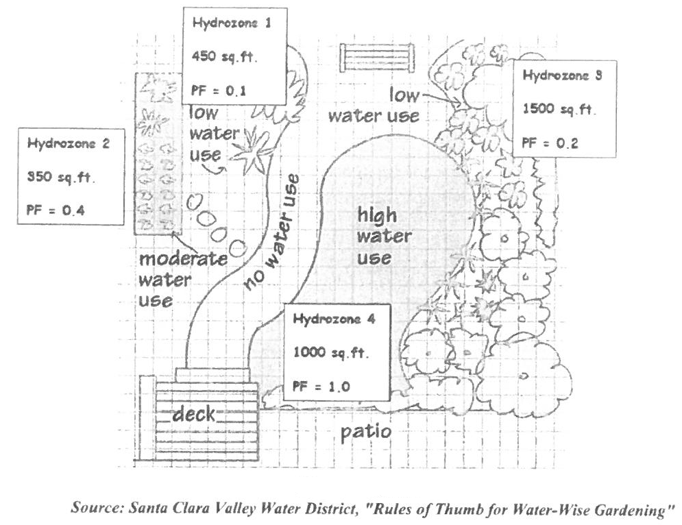
Figure 9.75.040-A
b.
Identify each hydrozone as low, moderate, high water, or mixed water use. Temporarily irrigated areas of the landscape shall be included in the low water use hydrozone for the water budget calculation.
c.
Identify recreational areas;
d.
Identify areas permanently and solely dedicated to edible plants;
e.
Identify areas irrigated with recycled water;
f.
Identify type of mulch and application depth (three (3)-inch minimum within all planting areas);
g.
Identify soil amendments, type, and quantity;
h.
Identify type and surface area of water features;
i.
Identify any applicable rain harvesting or catchment technologies and its 24-hour retention or infiltration capacity;
j.
Identify any applicable graywater discharge piping, system components and area(s) of distribution;
k.
Attach a completed Water Efficient Landscape Worksheet with hydrozone information table and water budget calculations.
l.
Soils Management Report. In order to reduce runoff and encourage healthy plant growth, a soil management report shall be completed by the project applicant, or his/her designee, as follows:
1)
Submit soil samples to a laboratory for analysis and recommendations.
2)
Soil sampling shall be conducted in accordance with laboratory protocol, including protocols regarding adequate sampling depth for the intended plants.
3)
The soil analysis shall include:
a)
Soil texture;
b)
Infiltration rate determined by laboratory test or soil texture infiltration rate table;
c)
Ph;
d)
Total soluble salts;
e)
Sodium;
f)
Percent organic matter; and
g)
Recommendations.
4)
In projects with multiple landscape installations (i.e., production home developments) a soil sampling rate of 1 in 7 lots or approximately 15% will satisfy this requirement. Large landscape projects shall sample at a rate equivalent to 1 in 7 lots.
5)
The project applicant, or his/her designee, shall comply with one of the following:
a)
If significant mass grading is not planned, the soil analysis report shall be submitted to the local agency as part of the Landscape Documentation Package; or
b)
If significant mass grading is planned, the soil analysis report shall be submitted to the local agency as part of the Certificate of Completion.
6)
The soil analysis report shall be made available, in a timely manner, to the professionals preparing the landscape design plans and irrigation design plans to make any necessary adjustments to the design plans.
7)
The project applicant, or his/her designee, shall submit documentation verifying implementation of soil analysis report recommendations to the local agency with Certificate of Completion.
B.
Irrigation Design Plan. All irrigation plans shall contain the following minimum information:
1.
Location and size of separate water meters for landscape, if applicable.
2.
Location, type and size of all components of the irrigation system, including controllers, main and lateral lines, valves, sprinkler heads, moisture sensing devices, rain switches, quick couplers, pressure regulators, and backflow prevention devices;
3.
A table including the manufacturer and a description of all parts used in the irrigation plan.
4.
Details of the backflow prevention devices, valves, sprinkler heads, controllers, etc.
5.
Static water pressure at the point of connection to the public water supply;
6.
Flow rate (gallons per minute), application rate (inches per hour), and design operating pressure (pressure per square inch) for each station;
7.
Recycled water irrigation systems, if any;
8.
The following statement: "I have complied with the criteria of the ordinance and applied them accordingly for the efficient use of water in the irrigation design plan"; and
9.
The signature of a licensed landscape architect, certified irrigation designer, licensed landscape contractor, or any other person authorized to design an irrigation system.
C.
Additional Requirements. Landscape areas with an average WUCOL Plant Factor exceeding 0.3 and/or landscape areas that exceed 2,500 square feet, shall also provide the following documentation upon submittal:
1.
Water Efficient Landscape Worksheet;
a.
Hydrozone information table;
b.
Water budget calculations;
1)
Maximum Applied Water Allowance (MAWA);
2)
Estimated Total Water Use (ETWU);
2.
Soil management report;
3.
Grading design plan.
D.
Project Completion. Landscape areas 500 square feet or greater shall submit the following to the Planning Division prior to the project's final inspection for occupancy:
1.
A Certificate of Completion shall be provided to the Planning Division, local water purveyor and the property owner or his or her designee, containing the following information:
a.
Project information sheet that contains:
1)
Date;
2)
Project name;
3)
Project applicant name, telephone, and mailing address;
4)
Project address and location; and
5)
Property owner name, telephone, and mailing address;
b.
Certification by either the signer of the landscape design plan, the signer of the irrigation design plan, or the licensed landscape contractor that the landscape project has been installed per the approved Landscape Documentation Package;
1)
Where there have been significant changes made in the field during construction, these "as-built" or record drawings shall be included with the certification;
2)
A diagram of the irrigation plan showing hydrozones shall be kept with the irrigation controller for subsequent management purposes.
3)
Irrigation scheduling parameters used to set the controller.
2.
Landscape and Irrigation Maintenance Schedule. Landscapes shall be maintained to ensure water use efficiency. A regular maintenance schedule shall be submitted with the Certificate of Completion.
a.
A regular maintenance schedule shall include, but not be limited to, routine inspection; auditing, adjustment and repair of the irrigation system and its components; aerating and dethatching turf areas; topdressing with compost, replenishing mulch; fertilizing; pruning; weeding in all landscape areas, and removing obstructions to emission devices. Operation of the irrigation system outside the normal watering window is allowed for auditing and system maintenance.
b.
Repair of all irrigation equipment shall be done with the originally installed components or their equivalents or with components with greater efficiency.
c.
A project applicant is encouraged to implement established landscape industry sustainable Best Practices for all landscape maintenance activities.
3.
Irrigation Audit, Irrigation Survey, and Irrigation Water Use Analysis.
a.
All landscape irrigation audits shall be conducted by a local agency landscape irrigation auditor or a third party certified landscape irrigation auditor. Landscape audits shall not be conducted by the person who designed the landscape or installed the landscape.
b.
In large projects or projects with multiple landscape installations (i.e., production home developments) an auditing rate of 1 in 7 lots or approximately 15% will satisfy this requirement.
c.
The project applicant shall submit an irrigation audit report with the Certificate of Completion to the Planning Division that may include, but is not limited to: inspection, system tune-up, system test with distribution uniformity, reporting overspray or run off that causes overland flow, and preparation of an irrigation schedule, including configuring irrigation controllers with application rate, soil types, plant factors, slope, exposure and any other factors necessary for accurate programming.
(Ord. No. 479, § 3(Att. A), 1-12-2016)
9.75.050 - Water Conserving Landscape Design Standards
For the efficient use of water, a landscape shall be carefully designed and planned for the intended function of the project. All landscape design plans must meet the following design criteria:
A.
Use only those plants officially approved on the currently adopted plant list or alternative plants as approved by the Director.
B.
Any plant from the list may be selected for the landscape, providing the Estimated Total Water Use in the landscape area does not exceed the Maximum Applied Water Allowance.
C.
Turf Limitations on New Landscaping Projects
1.
Turf shall not exceed twenty-five (25) percent of the total landscape in any residential areas.
2.
Except for Special Landscape Areas, the use of turf for non-residential uses is prohibited.
3.
Turf is not allowed on slopes greater than 25% where the toe of the slope is adjacent to an impermeable hardscape and where 25% means 1 foot of vertical elevation change for every 4 feet of horizontal length (rise divided by run × 100 = slope percent).
4.
Turf is prohibited within public rights-of-way, including parkways.
D.
Each zone (hydrozone) shall have plant materials with similar water use.
E.
Water Features
1.
Recirculating water systems shall be used for water features.
2.
Where available, recycled water shall be used as a source for decorative water features.
3.
Surface area of a water feature shall be included in the high water use hydrozone area of the water budget calculation.
4.
Pool and spa covers are highly recommended.
F.
High water use plants, characterized by a plant factor of 0.7 to 1.0, are prohibited in street medians or right-of-way.
G.
The use of invasive plant species, such as those listed by the California Invasive Plant Council, is strongly discouraged.
H.
Artificial turf/plants are not limited.
I.
Compacted soils, including areas of caliches, shall be transformed to a friable condition. On engineered slopes, only amended planting holes need meet this requirement.
J.
Add soil additives within landscape areas to increase the water holding capacity of the soil and improve the health of the plants. For landscape installations, compost at a rate of a minimum of four cubic yards per 1,000 square feet of permeable area shall be incorporated to a depth of six inches into the soil. Soils with greater than 6% organic matter in the top 6 inches of soil are exempt from adding compost and tilling.
K.
Cover final soil surfaces with organic or inorganic mulches to insulate against soil temperature extremes and conserve moisture. A minimum three inch (3") layer of mulch shall be applied on all exposed soil surfaces of planting areas except in turf areas, creeping or rooting groundcovers, or direct seeding applications where mulch is contraindicated.
L.
Unity and Continuity. Landscape unity and continuity may be significantly enhanced through the selection of a dominant tree and shrub species. Such dominance shall be established by making the selected species clearly in the majority of sixty (60) percent or more.
M.
Tree and Shrub Placement in Proximity to Fire Hydrant. Trees, as measured from trunk center, shall be placed a minimum of five (5) feet from fire hydrants. Shrubs, as measured from their mature perimeter, shall be located a minimum of five (5) feet from the rear of a fire hydrant. In no case shall any material other than groundcover be placed between the street or roadway and within fifteen (15) feet of either side or front of a fire hydrant (Figure 9.75.050-A).
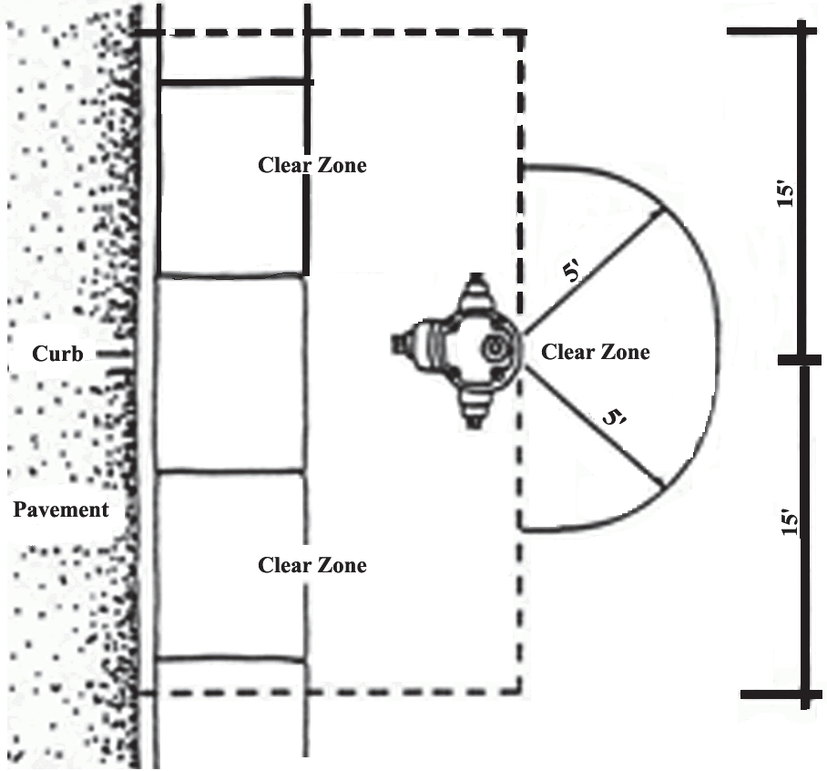
Figure 9.75.050-A Fire Hydrant Clear Zone
N.
Ground Surface Treatment
1.
Pre-Treatment of Ground Surfaces Required. A mesh weed barrier shall be applied to the ground prior to the placement of natural surface materials (decomposed granite, gravel, crushed rock, river run rock, etc.) in any landscaped area to prevent weed growth.
2.
Inorganic Ground Cover. Inorganic ground covers (decomposed granite, crushed stone, etc.) shall be of a natural color harmonious with other site and architectural materials and shall be installed to a minimum depth of two (2) inches.
3.
Plant Cover/Dust Control. Unless otherwise provided for within this Chapter, all portions of a development site (including future building pads) not occupied by buildings, structures, paved improvements, and required landscape areas shall be temporarily landscaped with plant materials in accordance with this Chapter or treated with an appropriate inorganic ground cover and maintained in a weed and dust free condition.
O.
Plant Massing. The massing of trees and shrubs into groups containing three (3) or more plants is required unless standards elsewhere within this Chapter require only a single element, e.g., single trees within parking lot planter islands. Planting of single shrub specimens, unless used to repeat an element already established within a massed planting within the same visual area, is prohibited.
P.
Plant Groupings (Hydrozones). The grouping of plant species commonly found together in natural associations or of common environmental requirements (soil type, water, sun exposure, temperature limitations, etc.) is required.
Q.
Plant Spacing. In order to foster a more natural look, an uneven spacing of plants is required unless such plants are being used to create a massed shrub or groundcover bed. The spacing of shrubs shall be sufficient to allow plants to reach their natural mature size and form.
R.
Consistency with Existing Streetscape Standards. Street frontage landscaping shall be consistent with any previously adopted specific streetscape standards.
(Ord. No. 479, § 3(Att. A), 1-12-2016)
9.75.060 - Landscape Area and Material Requirements
A.
Landscape Area Requirements for Residential Tracts, Multi-Family Residential and All Non-Residential Development. All portions of a development site not utilized for building development, service areas, paved or improved storage areas, parking, driveways, etc., shall be landscaped. Minimum areas of landscaping are as follows:
1.
Front Building Setback/Street Right-of-Way Areas. All front building setback and street right-of-way areas located between on-site improvements and the back of existing or future public sidewalks or street curbs, except needed access driveways, shall be fully landscaped, unless otherwise provided for in this Development Code.
2.
Parking Lot Area. The following landscaping standards apply to parking lots (Figures 9.75.060-A, B and C):
a.
In order to reduce the "heat island effect" of large expanses of unprotected paved areas, a minimum of thirty (30) percent of the interior parking surface of all parking lots shall be shaded at the maturity of the landscaping.
b.
Provide a minimum of one (1) tree (minimum fifteen (15) gallon size when planted) for each seven (7) parking spaces located so as to visually disrupt long rows of parking spaces, trees may be clustered where appropriate.
c.
A thirty-six to forty-two (36—42)-inch high decorative masonry wall, hedge or landscaped berm, as measured from the finished grade of the parking area, shall also be used adjacent to public rights-of-way to screen the parking area. The height of the screening wall or berm may be reduced when the parking lot is below grade. Horizontal and vertical variations in the design of screening walls are required where the length of such walls exceed forty (40) feet. Said variations are subject to Planning Staff approval.
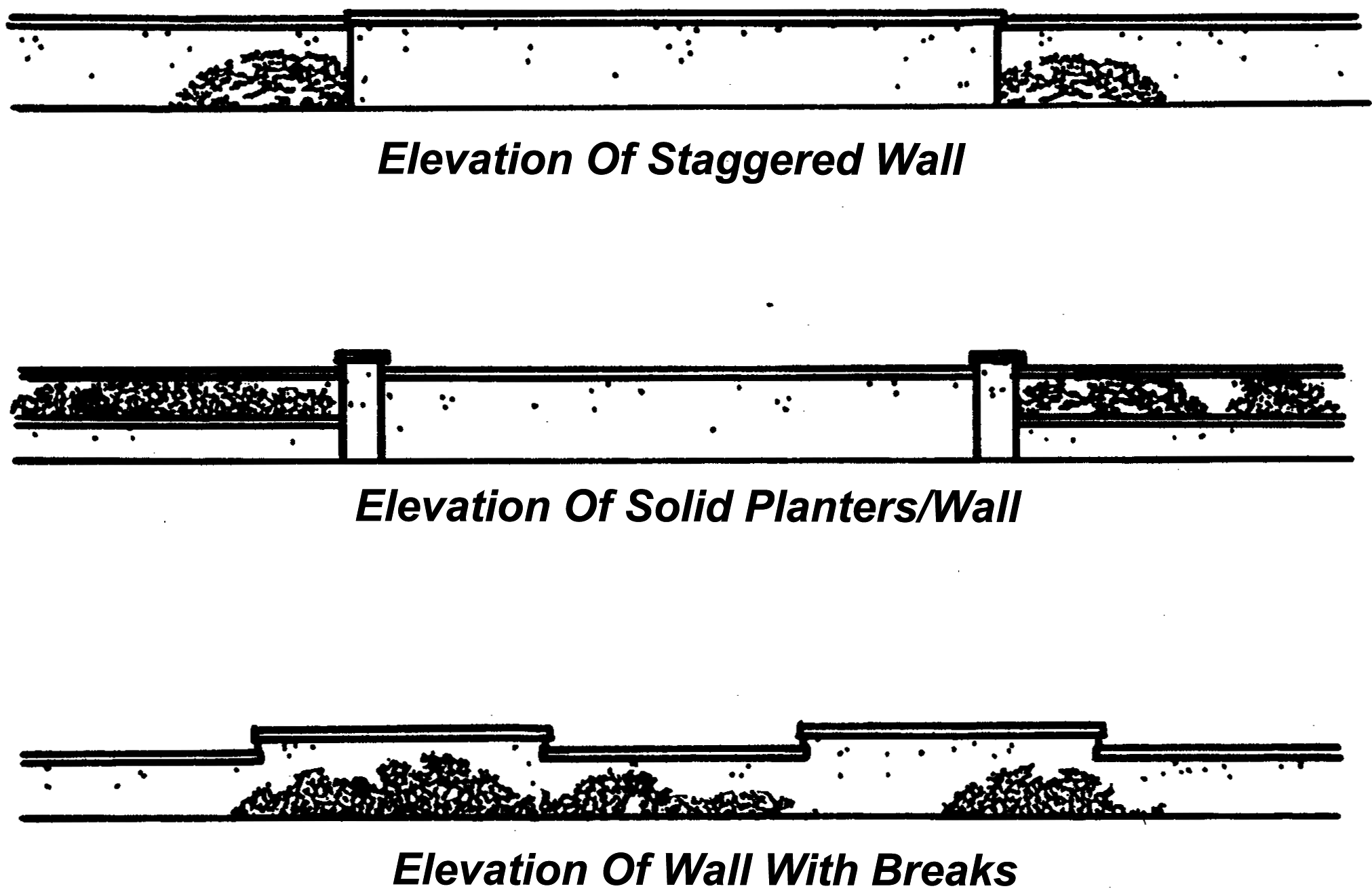
Figure 9.75.060-A Recommended Design Features and Materials
d.
A minimum of five (5) percent of the interior parking surface area of all parking lots shall be landscaped. Such percentage may be achieved by combining the following:
1)
Planter islands a minimum of five (5) feet in width shall be located at the ends of all rows of parking stalls between the last stall and any drive aisle. Where drive aisles are curved, alternative dimensions with similar area may be approved (Figure 9.75.060-B); and
2)
Planter islands, shall be uniformly distributed throughout the interior parking area, and protected by raised curbs (Figure 9.75.060-B); or
3)
Planter strips, located between double rows of parking stalls, shall be a minimum of four (4) feet in width. Each parking stall may overhang two (2) feet into this area (Figure 9.75.060-B).
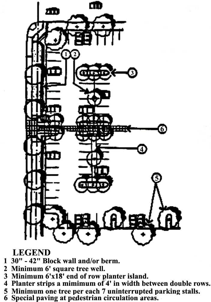
Figure 9.75.060-B Planter Islands/Strips
e.
Trees within parking lots shall be kept trimmed to a minimum clear canopy height of six (6) feet for visual safety.
f.
A landscaped strip with a minimum width of ten (10) feet shall be provided where parking lots are adjacent to a public right-of-way or residential uses or districts, unless otherwise provided for in this Code.
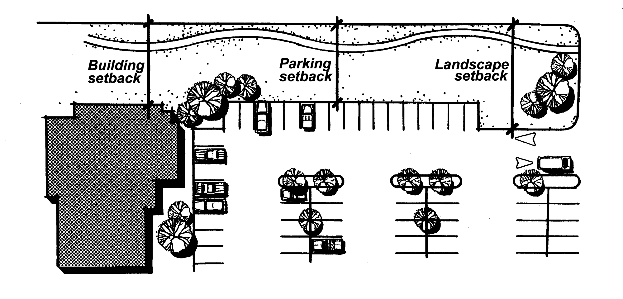
Figure 9.75.060-C Landscape Areas
3.
Landscape Buffers/Perimeter Landscape Strips
a.
Landscape Buffers. When providing a buffer between commercial/industrial and residential uses or districts the following features are required:
1)
Landscaping shall include one (1) tree for each 200 square feet of required landscape area. Said tree shall be a minimum fifteen (15) gallon size when planted, twenty (20) percent of such required trees shall be twenty-four (24)-inch box size; and
2)
A six (6)-foot decorative masonry wall reflecting the design, material, and color of the primary structures within the project, excluding approved gate openings; and
3)
Evergreen trees a minimum of six (6) feet in height planted at a maximum spacing of twenty (20) feet on center and shrubs planted at a rate of five (5) per one hundred linear feet.
4.
Front Building Setback Area. Landscaping in the front building setback area shall be provided at a minimum rate of one (1) tree and six (6) shrubs per thirty (30) linear feet of frontage plus sufficient groundcover plantings to provide combined shrub and ground coverage of fifty (50) percent of the total landscaped area. Trees and shrubs may be grouped, but gaps between groupings of plants shall not exceed forty (40) feet.
5.
Other Perimeter Areas. Landscaping in other perimeter areas shall be provided at a minimum rate of one (1) tree and six (6) shrubs per forty (40) linear feet plus sufficient groundcover plantings to provide combined shrub and ground coverage of forty (40) percent of the total landscaped area, except where screening is required. Trees shall be a minimum fifteen (15) gallon size when planted, twenty (20) percent of which shall be twenty-four (24) inch box size. Trees and shrubs may be grouped, but gaps between groupings of plants shall not exceed fifty (50) feet.
B.
Landscape Improvement Requirements. The following minimum landscape improvements are required within the following landscape areas:
1.
Single-Family Residential Tracts and Multi-Family Residential Developments
a.
Common open space/retention areas. A minimum of one (1) tree and six (6) shrubs per 500 square feet of open space plus such additional vegetative ground cover as is necessary to cover a minimum of fifty (50) percent of the total landscaped area with shrubs, ground cover and turf.
b.
Arterial and collector street rights-of-way. Arterial and collector street rights-of-way adjacent to and within single and multi-family residential developments shall be landscaped at a rate of one (1) tree and three (3) shrubs per 30 linear feet plus such vegetative ground cover necessary to cover a minimum of forty (40) percent of the total landscaped area with shrubs and ground cover. Turf is prohibited within public rights-of-way.
2.
Commercial/Office/Institutional Developments. One (1) tree and six (6) shrubs per 500 square feet of interior open space plus such additional ground cover which, upon maturity, will cover a minimum of fifty (50) percent of all interior open space surfaces. The inclusion of turf is subject to the limitations established in Section 9.75.050.
3.
Industrial Developments. One (1) tree and six (6) shrubs per 750 square feet of interior open space plus such additional vegetative ground cover which, upon maturity, will cover a minimum of forty (40) percent of all interior open space surfaces. The inclusion of turf is subject to the limitations established in Section 9.75.050.
4.
Grading in the Front Building Setback. Front setback areas shall be graded in a manner which creates natural and pleasing ground forms in accordance with the following guidelines:
a.
A maximum of fifty (50) percent of the front building setback area may be used for storm water retention;
b.
Soil excavated to create needed retention basins shall, within the slope limitations established below, be used to create complementary earth mounds elsewhere within the same front building setback area;
c.
Earth mounds with a maximum slope ratio of four to one (4:1), horizontal to vertical, shall be located and designed to minimize street views into retention basins;
d.
Grading and other site preparation shall preclude the run-off of rain and/or irrigation water from landscaped surfaces onto paved surfaces.
5.
Finished Grade Surfaces. All landscaped areas shall be graded so that finish grade surfaces of all nonliving materials (i.e., decomposed granite, crushed rock, mulch, and the like) are at least one and one-half (1½) inches below concrete or other paved surfaces.
6.
Protection of Landscaped Areas. Landscaped areas adjacent to vehicular drives or parking areas shall be protected by a six (6)-inch vertical curb. Areas surfaced with different materials (i.e., lawn and decomposed granite) shall be separated by masonry, wood, or mowing strips.
C.
Landscape Requirements for Single-Family In-Fill Development. The following minimum landscape improvements are required within the following landscape areas:
1.
The minimum landscaped area shall be determined as follows:
a.
Front yard - 25% of the land area within the required front yard setback or 5,000 square feet, whichever is less.
b.
Street side yard - 25% of the land area within the required street side yard setback or 2,500 square feet, whichever is less. This area can further be reduced with the installation of a solid wall or fence, then only the strip of land between the wall or fence and public right-of-way shall be landscaped.
2.
Minimize the removal of native vegetation and incorporate these plants into the final landscape design.
3.
The required landscape areas shall include a mix of organic and inorganic materials (i.e., gravel, crushed rock, river run rock, etc.). Decomposed granite is not a permitted ground cover within any irrigated, landscaped area.
4.
A minimum of four (4) yards of compost per 1,000 square feet of irrigated landscaped area is required.
5.
A mesh weed barrier is required prior to the placement of inorganic ground cover.
6.
In all areas, imported, inorganic ground cover shall be installed to a minimum depth of two (2) inches.
7.
In order to minimize run-off and increase water infiltration, areas identified with high caliche concentrations will require excavation, to a level below the caliche, prior to landscape installation.
8.
Xeriscape landscaping is required for all front yards, street side yards. The use of turf is strongly discouraged.
9.
The use of turf may not exceed twenty-five (25) percent of the total landscaped area.
10.
Low water use plants and low volume irrigation systems are to be used on all additional landscape areas.
11.
The use of artificial turf is not limited.
12.
A minimum of one (1) tree and ten (10) shrubs shall be required per fifty (50) feet of street frontage.
13.
Minimum size shall be five (5) gallon shrubs and fifteen (15) gallon trees.
14.
Fifty (50) percent of trees shall be canopy trees as defined within the Section 9.75.100 "Approved Plant List".
15.
Grouping of plants with similar water needs is required.
16.
Uneven spacing is required to create a natural look.
17.
Deferment of Landscape Installation Provisions. No Building Permit shall be approved or issued unless the Planning Division finds that the project satisfies the criteria set forth in this Chapter. Residential in-fill lots not built and permitted to the owner of the property is exempt from this requirement, provided that a deposit of an amount adopted by Council Resolution is submitted prior to issuance of building permits. For this exemption, a landscape plan implementing the criteria of this Chapter must be submitted and approved by the Planning Division prior to occupancy of the residence. The property owner is required to install the approved landscaping within six (6) months from the date of occupancy. Failure to complete the approved landscaping in said time frame will result in forfeiting the deposit to the Town and having the non-compliance of landscape requirements forwarded to the Code Enforcement Division for legal action. One extension of time not to exceed six (6) months may be approved at the discretion of the Director for special circumstances.
(Ord. No. 479, § 3(Att. A), 1-12-2016)
9.75.070 - Irrigation Design Standards
This section applies to landscaped areas requiring permanent irrigation, not areas that require temporary irrigation solely for the plant establishment period. For the efficient use of water, an irrigation system shall meet all the requirements listed in this section and the manufacturers' recommendations. The irrigation system and its related components shall be planned and designed to allow for proper installation, management, and maintenance. An irrigation design plan meeting the following design criteria shall be submitted as part of the Landscape Documentation Package.
A.
Automatic irrigation controllers are required and must use evapotranspiration or soil moisture sensor data and utilize a rain sensor. Sensors (rain, freeze, wind, etc.), either integral or auxiliary, that suspend or alter irrigation operation during unfavorable weather conditions shall be required on all irrigation systems, as appropriate for local climatic conditions. Irrigation should be avoided during windy or freezing weather or during rain.
B.
Irrigation controllers shall be of a type which does not lose programming data in the event the primary power source is interrupted.
C.
Pressure regulators shall be installed on the irrigation system to ensure the dynamic pressure of the system is within the manufacturer's recommended pressure range.
D.
Manual shut-off valves (such as a gate valve, ball valve, or butterfly valve) shall be installed as close as possible to the point of connection of the water supply to minimize water loss in case of an emergency (such as a main line break) or routine repair.
E.
Backflow prevention devices shall be required to protect the water supply from contamination by the irrigation system. A project applicant shall refer to the applicable local agency code (i.e., public health) for additional backflow prevention requirements.
F.
Flow sensors that detect high flow conditions created by system damage or malfunction are required for all non-residential landscapes and residential landscapes of 5,000 sq. ft. or larger.
G.
Master shut-off valves are required on all projects except landscapes that make use of technologies that allow for the individual control of sprinklers that are individually pressurized in a system equipped with low pressure shut down features.
H.
All irrigation emission devices must meet the requirements set in the ANSI standard, ASABE/ICC 802-2014, "Landscape Irrigation Sprinkler and Emitter Standard." All sprinkler heads installed in the landscape must document a distribution uniformity low quarter of 0.65 or higher using the protocol defined in ASABE/ICC 802-2014.
I.
The irrigation system shall be designed to prevent runoff, low head drainage, overspray, or other similar conditions where irrigation water flows onto non-targeted areas, such as adjacent property, non-irrigated areas, hardscapes, roadways, or structures.
J.
Relevant information from the soil management plan, such as soil type and infiltration rate, shall be utilized when designing irrigation systems.
K.
The design of the irrigation system shall conform to the hydrozones of the landscape design plan.
L.
The irrigation system must be designed and installed to meet, at a minimum, the irrigation efficiency criteria as described in the submitted Water Efficient Landscape Worksheet and the Maximum Applied Water Allowance.
M.
Areas less than ten (10) feet in width in any direction shall be irrigated with subsurface irrigation or other means that produces no runoff or overspray.
N.
In mulched planting areas, the use of low volume irrigation is required to maximize water infiltration into the root zone.
O.
Sprinkler heads and other emission devices shall have matched precipitation rates, unless otherwise directed by the manufacturer's recommendations.
P.
Head to head coverage is recommended. However, sprinkler spacing shall be designed to achieve the highest possible distribution uniformity using the manufacturer's recommendations.
Q.
Swing joints or other riser-protection components are required on all risers subject to damage that are adjacent to hardscapes or in high traffic areas of turfgrass.
R.
Check valves or anti-drain valves are required on all sprinkler heads where low point drainage could occur.
S.
For non-residential projects with landscape areas of 1,000 sq. ft. or residential irrigated landscapes of 5,000 sq. ft. or greater, a submeter(s), to measure landscape water use shall be installed. The submeter may be privately owned or provided by the water purveyor.
T.
At the time of final inspection, the permit applicant must provide the owner of the property with a certificate of completion, certificate of installation, irrigation schedule and a schedule of landscape and irrigation maintenance.
U.
It is highly recommended that the project applicant or local agency inquire with the local water purveyor about peak water operating demands (on the water supply system) or water restrictions that may impact the effectiveness of the irrigation system.
V.
Overhead irrigation shall not be permitted within 24 inches of any non-permeable surface. Allowable irrigation within the setback from non-permeable surfaces may include drip, drip line, or other low flow non-spray technology. The setback area may be planted or unplanted. The surfacing of the setback may be mulch, gravel, or other porous material. These restrictions may be modified if:
1.
The landscape area is adjacent to permeable surfacing and no runoff occurs; or
2.
The adjacent non-permeable surfaces are designed and constructed to drain entirely to landscaping; or
3.
The irrigation designer specifies an alternative design or technology, as part of the Landscape Documentation Package and clearly demonstrates strict adherence to irrigation system design criteria within this chapter. Prevention of overspray and runoff must be confirmed during the irrigation audit.
W.
Slopes greater than 25% shall not be irrigated with an irrigation system with an application rate exceeding 0.75 inches per hour. This restriction may be modified if the landscape designer specifies an alternative design or technology, as part of the Landscape Documentation Package, and clearly demonstrates no runoff or erosion will occur. Prevention of runoff and erosion must be confirmed during the irrigation audit.
X.
Hydrozone
1.
Each valve shall irrigate a hydrozone with similar site, slope, sun exposure, soil conditions, and plant materials with similar water use.
2.
Sprinkler heads and other emission devices shall be selected based on what is appropriate for the plant type within that hydrozone.
3.
Where feasible, trees shall be placed on separate valves from shrubs, groundcovers, and turf to facilitate the appropriate irrigation of trees. The mature size and extent of the root zone shall be considered when designing irrigation for the tree.
4.
Individual hydrozones that mix plants of moderate and low water use, or moderate and high water use, may be allowed if:
a.
Plant factor calculation is based on the proportions of the respective plant water uses and their plant factor; or
b.
The plant factor of the higher water using plant is used for calculations.
c.
Individual hydrozones that mix high and low water use plants shall not be permitted.
d.
On the landscape design plan and irrigation design plan, hydrozone areas shall be designated by number, letter, or other designation. On the irrigation design plan, designate the areas irrigated by each valve, and assign a number to each valve. Use this valve number in the Hydrozone Information Table. This table can also assist with the irrigation audit and programming the controller.
Y.
Irrigation Scheduling. For the efficient use of water, all irrigation schedules shall be developed, managed, and evaluated to utilize the minimum amount of water required to maintain plant health. Irrigation schedules shall meet the following criteria:
1.
Irrigation scheduling shall be regulated by automatic irrigation controllers.
2.
Overhead sprinkler irrigation shall be scheduled to operate during the months of May through October, between the hours of 6:00 p.m. and 9:00 a.m. and during the remaining months of November through April, between the hours of 9:00 a.m. and 3:00 p.m. to reduce water loss from wind and evaporation and to avoid ice during winter months. Drip irrigation and subterranean devices shall not be subject to this water window.
3.
For implementation of the irrigation schedule, particular attention must be paid to irrigation run times, emission device, flow rate, and current reference evapotranspiration, so that applied water meets the Estimated Total Water Use. Total annual applied water shall be less than or equal to Maximum Applied Water Allowance (MAWA). Actual irrigation schedules shall be regulated by automatic irrigation controllers using current reference evapotranspiration data (e.g., CIMIS) or soil moisture sensor data.
4.
Parameters used to set the automatic controller shall be developed and submitted for each of the following:
a.
the plant establishment period;
b.
the established landscape; and
c.
temporarily irrigated areas.
5.
Each irrigation schedule shall consider for each station all of the following that apply:
a.
irrigation interval (days between irrigation);
b.
irrigation run times (hours or minutes per irrigation event to avoid runoff);
c.
number of cycle starts required for each irrigation event to avoid runoff;
d.
amount of applied water scheduled to be applied on a monthly basis;
e.
application rate setting;
f.
root depth setting;
g.
plant type setting;
h.
soil type;
i.
slope factor setting;
j.
shade factor setting; and
k.
irrigation uniformity or efficiency setting.
(Ord. No. 479, § 3(Att. A), 1-12-2016)
9.75.080 - Enforcement/Reporting
A.
The Town shall administer programs that may include, but not be limited to, irrigation water use analysis, irrigation audits, and irrigation surveys for compliance with the Maximum Applied Water Allowance.
B.
All existing landscapes that were installed before December 1, 2015 and are over one acre in size, that have a water meter, the Town, or other designated authority, shall administer programs that may include, but not be limited to, irrigation water use analyses, irrigation surveys, and irrigation audits to evaluate water use and provide recommendations as necessary to reduce landscape water use to a level that does not exceed the Maximum Applied Water Allowance for existing landscapes.
C.
For landscapes that do not have a meter, the Town, or other designated authority, shall administer programs that may include, but not be limited to, irrigation surveys and irrigation audits to evaluate water use and provide recommendations as necessary in order to prevent water waste.
D.
All landscape irrigation audits shall be conducted by a certified landscape irrigation auditor.
(Ord. No. 479, § 3(Att. A), 1-12-2016)
9.75.090 - Public Education
The Town of Apple Valley shall make available information about water efficient landscaping to water users throughout the community. The Town will also use public education to encourage users to conserve water through voluntary compliance. In addition to education, the Town may use enforcement measures to curb water waste.
A.
Information shall be provided to new homeowners about designing, installing and maintaining water efficient landscapes.
B.
Model Homes. All model homes that are landscaped shall use signs and written information to demonstrate the principles of water efficient landscapes described in this ordinance as follows:
1.
Signs shall be used to identify the model as an example of a water efficient landscape featuring elements such as hydrozones, irrigation equipment, and others that contribute to the overall water efficient theme. Signage shall include information about the site water use as designed per the local ordinance; specify who designed and installed the water efficient landscape; and demonstrate low water use approaches to landscaping such as using native plants, graywater systems, and rainwater catchment systems.
2.
Information shall be provided about designing, installing, managing, and maintaining water efficient landscapes.
(Ord. No. 479, § 3(Att. A), 1-12-2016)
9.75.100 - Approved Plant List
All landscape shall strive to maximize the use of native species as provided in the approved plant list in this Section or as approved by the Director. Where native material is not appropriate for the intended use or appearance, plant species that are regionally adapted and non-invasive may be used with the approval of the Director. Source: University Of California Water Use Classification Of Landscape Species (WUCOLS IV).
(Ord. No. 479, § 3(Att. A), 1-12-2016)