
Lafayette City Zoning Code
SECTION 26
19.- DESIGN AND IMPROVEMENT STANDARDS
Sec. 26-19-1.- Suitability of land for subdivision.
Land subject to natural hazards such as flooding shall be considered unsuitable for residential occupancy or other uses which impair the health, safety or welfare of the inhabitants. Where such hazardous conditions exist on or adjacent to lands proposed for subdivision, the proposal shall be disapproved unless design of lots, streets and improvements eliminates all such hazards in the opinion of the planning commission and city council.
(Ord. No. 1986-01, § 2, 2-4-86)
Sec. 26-19-2. - Boundary survey and monumentation.
The boundary survey, internal property lines and monumentations shall meet all of the requirements of Articles 50—53, Title 38, C.R.S. Survey data shall be checked by the city engineer prior to approval of the final plat. The location of all monuments required by this section shall be indicated on the plat, and shall be installed as follows:
(a)
All street center line monuments shall be iron pin monuments five-eighths (⅝) inch in diameter and eighteen (18) inches long, set in concrete at least eight (8) inches in diameter and located in the ground at all points on street center lines where there is a change in direction or curvature, at all street intersections and at the radius point of a cul-de-sac.
(b)
All quarter corner, section corner monuments shall be set in monument boxes of a type approved by, or obtained through, the city, and shall be set to the finished grade before acceptance by the city.
(c)
All monuments shall have a cap bearing the number of the land surveyor setting the monuments.
(d)
Accuracy between all monuments shall be not less than one (1) part in ten thousand (10,000).
(e)
In no case shall monuments be set more than one thousand four hundred (1,400) feet apart.
(Ord. No. 1986-01, § 2, 2-4-86)
Sec. 26-19-3. - Lot and block design.
Each lot shall be designed to provide an adequate, accessible building site for a structure devoted to the intended use of the land. Except as provided in Section 26-18 (Planned Unit Development), each lot shall meet or exceed the minimum requirements of applicable zone district regulations and shall have a minimum of twenty-five (25) feet of frontage on a dedicated public street; the use of a private easement for principal access to a lot shall not be allowed. Lots with double frontage shall be avoided except where essential to provide separation from major arterials or because of the slope. Side lot lines shall be substantially at a right angle or radial to street lines when feasible. All lots shall have a defined rear yard. Blocks shall be at least three hundred (300) feet in length and not more than one thousand three hundred twenty (1,320) feet in length between street intersections. Pedestrian crosswalks or easements may be required in blocks whose lengths exceed one thousand (1,000) feet. Corner lots shall contain sufficient area to accommodate a building devoted to the intended use of the lot, plus a minimum front yard pursuant to the applicable zone district regulation adjacent to each bordering street.
(Ord. No. 1986-01, § 2, 2-4-86)
Sec. 26-19-4. - Planned unit development.
The planning commission may recommend approval of a subdivision which departs from the usual design of regularly platted lots and blocks as a part of a planned unit development in accordance with the provisions of Section 26-18 of this chapter.
Sec. 26-19-5. - Landscaping regulations and guidelines.
(a)
Applicability. This section shall apply to new residential and new nonresidential development, and any development requiring a site plan review, commenced after the effective date of Ordinance No. 2004-1 [March 2, 2004]. All landscape plans approved under prior ordinances of the City of Lafayette shall remain subject to fulfillment of all terms of such plans and to the provisions of subsection (c)(1)h., of this section, entitled "Maintenance".
(b)
Definitions. The words used in this section have the meaning set forth below:
Annual water budget/water budget means the target maximum amount of irrigation water applied to a landscaped area measured in gallons per square foot per year.
Application rate means the amount of water applied to a given area over a given time, usually measured in inches per hour.
Automatic controller means a timer, capable of operating valve stations to set the days and length of time of a water application.
Backflow prevention device means a safety device used to prevent pollution or contamination of a water supply due to the reverse flow of water from an irrigation system.
Common open area means areas held in private ownership and designated for shared use by common owners, their guests and invitees, and/or members of an owner's association, and that is improved with paved plazas or patios, landscape plantings, or natural plant restoration.
Established landscape means the point at which plants in the landscape have developed roots into the soil adjacent to the root ball.
Establishment period means the first three hundred sixty-five (365) days of growing season after installing the plant in the landscape.
Evapotranspiration (abbreviated as ET) means water evaporated from adjacent soil surfaces and transpired by plants during a specific time.
ET reference location means the major city identified within the State of Colorado as the reference for evapotranspiration rates based on the area's climatic conditions. (e.g. Denver Colorado Springs, Grand Junction, Pueblo).
Flow rate means the rate at which water flows through pipes and valves (gallons per minute or cubic feet per second).
Hydrozone means a portion of the landscaped area having plants with similar water needs that are served by a single irrigation valve or set of irrigation valves with the same schedule.
Infiltration rate means the rate of water entry into the soil expressed as a depth of water per unit of time (inches per hour).
Landscaped area means an entire parcel of real property less the building footprint, driveways, nonirrigated portions of parking lots, hardscapes (such as decks and patios), and other nonporous areas. Water features are included in the calculation of the landscaped area.
Landscaping and/or landscape improvements means plantings of grass, shrubs, trees or similar living plants, with minimal use of other ground surface treatment such as decorative rock, bark, or stone. These inert materials are allowed to be used in conjunction with live material in planting beds, but do not count toward the calculations of required landscaping and/or landscaping improvements.
Mulch means any organic material such as leaves, bark, wood chips, straw, or inorganic material such as crushed stone or gravel, or other materials left loose and applied to the soil surface for the beneficial purpose of reducing evaporation.
Overhead sprinkler irrigation systems means those sprinkler irrigation systems characterized by high flow rates including but not limited to pop-ups, impulse sprinklers, rotors, and similar devices.
Overspray means the water that is delivered beyond the landscaped area, wetting pavements, walks, structures, or other nonlandscaped areas.
Station means an area served by one valve or by a set of valves that operate simultaneously.
Street tree means a shade or ornamental tree planted along public or private streets and drives to provide shade to reduce heating of pavements, provide spatial definition and visual enhancement. Trees of a Salicacease, genus Salix (willow), Populus (poplar, cottonwood), and Acer negundo (female boxelder), and all fruit-bearing trees do not qualify as street trees.
Turf means a surface layer of earth containing mowed grass with its roots.
Valve means a device used to control the flow of water in an irrigation system.
(c)
Landscape design.
(1)
Landscape plan. All land development applications required to be accompanied by a landscape plan per section 26-17 shall have such landscape plan comply with the requirements of section 26-19-5. The required landscape plan shall be prepared and stamped by a Colorado licensed landscape architect, except plans for a single-family residence or multi-family residential developments containing four (4) or fewer units, not including common areas. Building permit applications for individual single-family residences do not require landscape plans, but shall comply with section 26-19-5(d)(1) and (3).
a.
Street trees. Landscape improvements shall create an orderly, irrigated, managed landscape. All neighborhoods shall have tree-lined streets. Street trees shall include a mix of species and be aligned in straight rows. Street trees shall be placed within the right-of-way tree lawn or within ten (10) feet of the back of curb where no tree lawn exists. Trees installed along streets that will be widened in the future, to the extent that such widening is known, shall take into account plans for future widening of streets so that established trees will not be disturbed during future construction.
b.
Landscape design criteria. Landscape improvements shall be an integral part of the overall site design for each property. Landscape improvements shall be deemed to be water-efficient when the approved landscape plan indicates an annual water budget of fifteen (15) gallons per square foot per year. Landscape improvements shall be designed to complement and enhance the character of neighborhoods and shall follow these guidelines:
1.
Landscaped areas shall be configured to maximize their interconnectivity within the site, and to natural areas and landscaped areas in adjacent developments. Small, isolated islands of landscaping shall be avoided except as required in parking lots and for screening along roadways.
2.
Enhance functional open area through the creation of outdoor rooms appropriate to the location and purpose of the open area within the development. This can be accomplished through a combination of plantings, fencing, berms, and by using natural features on the site.
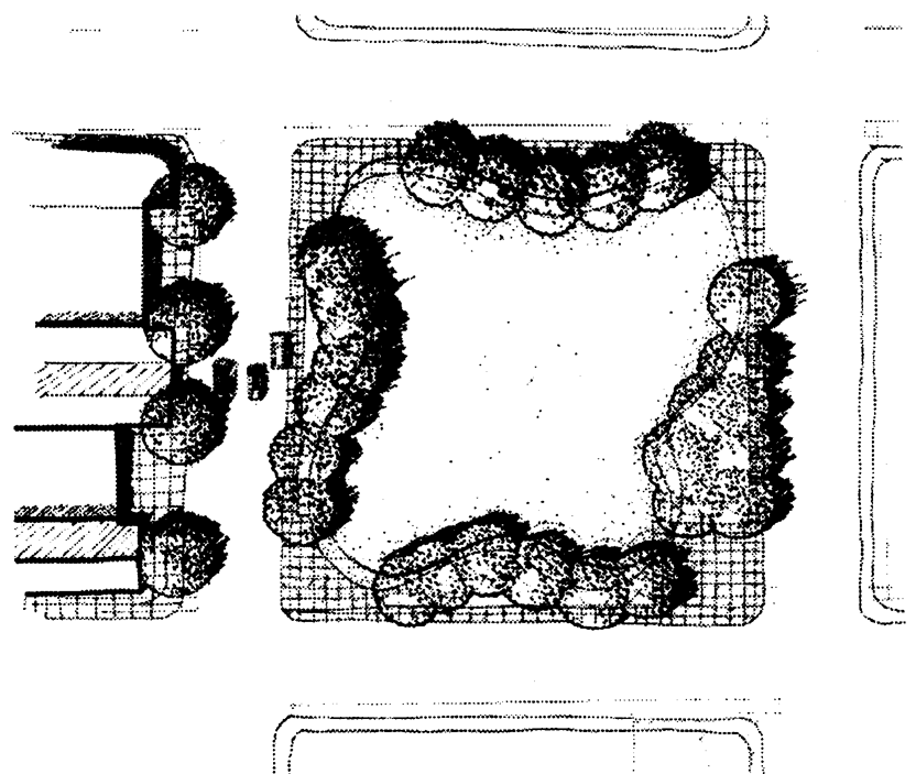
Figure 19-1
Use plantings and berms to create outdoor rooms in common open-area areas.
3.
Landscape improvements in all developments shall be compatible with the character of the proposed development and the surrounding area to reinforce neighborhood identity.
4.
Landscape design shall enhance natural features, drainage ways and environmental resources.
5.
Spacing of trees shall allow for their mature spread.
6.
All landscape improvements shall incorporate the elements of gateway, path and destination into the design of landscapes. Gateways are entries that provide transitions from one space to another. Pathways are routes that lead to a destination. Destinations are focal points that can include anything from a garden bench at the end of a path to a civic building at the end of a street.
7.
Landscaping shall be no more than thirty-six (36) inches high in mature height when located in a sight distance triangle as defined in section 26-14-16.
8.
Property owners shall use the following water efficient design principles to facilitate water conservation:
i.
Design planting schemes for water conservation;
ii.
Create lawns of appropriate size, shape, and type of turf;
iii.
Use of mulch to maintain soil moisture and reduce evaporation;
iv.
Group plants by hydrozone;
v.
Improve the soil with organic matter if needed;
vi.
Design and maintain efficient irrigation systems as described in section 26-19-5(c)(1)c., entitled "Irrigation Design Criteria" below; and
vii.
Maintain the plantings and irrigation system for water efficiency, as described in section 26-19-5(c)(1)c., entitled "Irrigation design criteria" below.
9.
Plants of any water need may be used in the landscape, provided that the total annual water use of the landscaped area does not exceed the annual water budget of fifteen (15) gallons per square foot per year.
10.
Plants having similar water use shall be grouped together in distinct hydrozones (see Appendix A), which shall be shown on the landscape plan.
11.
High hydrozones shall be separated from low and very low hydrozones by moderate hydrozones whenever possible.
12.
Plants shall be selected appropriately based upon their adaptability to the climatic, geologic, and topographical conditions of the site. Protection and preservation of native species and natural areas is encouraged. The planting of trees is encouraged wherever it is consistent with the other provisions of this section.
13.
Landscaped areas less than eight (8) feet wide shall be landscaped with moderate, low, or very low hydrozone plants (see Appendix A). Public street right-of-way plantings are excepted from this requirement.
14.
All plantable areas not covered with turf or other suitable plants shall be covered with a minimum of four (4) inches of a mulch to retain water, and inhibit weeds. Exceptions to the provision of mulch for low and very low water areas shall be considered based on individual plant requirements in those areas. Nonporous fabrics (e.g. plastic) shall not be placed under mulches.
15.
Soil preparation shall be provided for all plants. Soil preparation shall include scarification to six (6) inches, with organic or other planting soil amendments as specified by the landscape designer or landscape architect.
16.
Recirculating water shall be used for decorative water features.
17.
Artificial plants, artificial grasses, and other artificial plant material are prohibited as a means of complying with these landscaping regulations. Such artificial materials are not entirely prohibited. They may be used for athletic fields and other uses, but shall not be used in any manner to satisfy the requirements of these landscape regulations.
c.
Irrigation design criteria. Except as otherwise allowed by this section, all required landscaping shall be irrigated for plant establishment and maintenance. Irrigation system improvements shall be designed in conformance with the following criteria. Additional advisory technical design criteria are available in the planning and building office.
1.
Required landscaping in developments shall be irrigated with a permanent irrigation system, provided however, an exception for hand watering may be provided for low and very low hydrozones in accordance with section 26-19-5(c)(1)i., entitled "Adjustment of requirements". Exemptions shall be considered by the planning director for low and very low hydrozone plantings in accordance with section 26-19-5(c)(1)i., entitled "Adjustment of requirements".
2.
Temporary irrigation (less than one (1) season) may be used to establish native grasses and native vegetation.
3.
Use of nontreated water for irrigation is encouraged if a permanent, legal, suitable supply is available.
4.
The property owner shall use the following criteria for irrigation design.
i.
Each valve shall irrigate a landscape with similar site, slope and soil conditions and plant material with similar hydrozone watering needs.
ii.
Adjustment of soil types, infiltration rate and slopes shall be undertaken in order to prevent runoff onto adjacent property, and overspray. Proper irrigation equipment, schedules, and repeat cycles shall be used to minimizing runoff.
iii.
Turf and nonturf areas shall be irrigated on separate valves.
iv.
Drip emitters and sprinklers shall be placed on separate valves.
v.
Bubblers for trees shall be placed on a separate valve. A bubbler shall not exceed one and one-half (1.5) gallons per minute (gpm) for each device.
5.
The property owner shall use the following hydraulic principles when designing the irrigation system.
i.
When practical, separate landscape water meters are encouraged to be installed for all regulated landscapes.
ii.
The irrigation system shall be designed to provide peak season irrigation during night hours.
iii.
The tap size shall be based on the water demand of the site and shall take into consideration the areas of each plant type (e.g., turf, native seed, perennials and annuals and shrubs), the evapotranspiration for the site, the water demand of each plant type at peak season, and the water window.
iv.
Turf and grass area irrigation shall be designed in accordance with the following requirements:
(aa)
No single zone shall mix head types, such as rotors and pop-up spray heads on the same zone.
(bb)
Sprinklers shall be spaced for "head-to-head" coverage, where the spray pattern from one head will reach to the next head; all sprinkler heads shall be spaced at a maximum of fifty (50) percent of the design performance diameter of the sprinkler.
(cc)
No overhead sprinkler irrigation systems shall be installed in landscaped areas less than eight (8) feet wide. Public street right-of-way landscaping shall be excepted from this requirement.
(dd)
Small landscaped areas (twenty-five (25) feet wide or less) shall be irrigated with fixed nozzle pop-up spray heads with matched precipitation nozzles. Nozzles shall be sized to provide head to head coverage. Heads shall pop-up a minimum of four (4) inches in turf areas. Heads can be specified with pressure reducing features, where needed.
(ee)
Large landscaped areas (wider than twenty-five (25) feet) shall be irrigated with gear driven rotor heads with a minimum precipitation rate of forty-five hundredths (0.45) of an inch per hour for a full circle head. Heads shall pop-up a minimum of four (4) inches in turf areas.
v.
Shrub bed areas with plant material of one (1) gallon in size or larger shall be irrigated with a drip or subsurface system.
vi.
Perennial and annual beds shall be spray irrigated with twelve-inch pop-up spray heads with a maximum spacing of ten (10) inches on center.
vii.
All irrigation control systems shall be equipped with an automatic rain shut-off device.
6.
Irrigation control systems shall be employed that offer flexibility in programming as follows:
i.
All irrigation systems shall include an electric automatic controller with multiple programs and multiple repeat and rest cycle capabilities and a flexible calendar program.
ii.
All controllers shall be capable of temporarily shutting down the system by utilizing internal/external options such as rain and wind sensors.
iii.
The controller shall have the ability to adjust run times based on a percentage of maximum evapotranspiration rate.
iv.
Each zone/valve shall have its own station on the controller. The exception is drip valves, which may be doubled on the controller.
7.
Installation of irrigation systems shall be in accordance with an approved final irrigation plan.
8.
Property owner shall keep a set of "as-built" drawings of irrigation system with dimensions shown for irrigation components.
9.
Property owners shall operate their irrigation system in accordance with the approved final landscape plan.
10.
Water features shall be considered as high water zones (see Appendix A). The total amount of water for irrigation, plus water needed for any water features, shall be combined in the annual water budget.
d.
Environmental criteria.
1.
Landscapes shall consist of a variety of species to enhance biodiversity. No one species may make up more than twenty-five (25) percent of the total nongrass plant materials within the landscaped area.
2.
All healthy trees having a caliper of four (4) inches in size or larger shall be preserved whenever possible they do not substantially interfere with the construction of buildings on the property or with the grading of the property as may be necessary for the construction of buildings on the property. Trees having a caliper of four (4) inches in size which are removed shall be replaced by trees of no less than two-inch caliper, with the total gross caliper inches of the replacement trees being equal to or greater than the total caliper inches of those trees removed. This requirement shall not prevent the removal of unhealthy trees in conjunction with site development.
3.
Trees shall be located to provide summer shade and limit winter shade on walks, parking lots, and streets.
4.
A combination of plantings, berms, walls and fences shall be used as appropriate to buffer sensitive habitat and noncompatible uses.
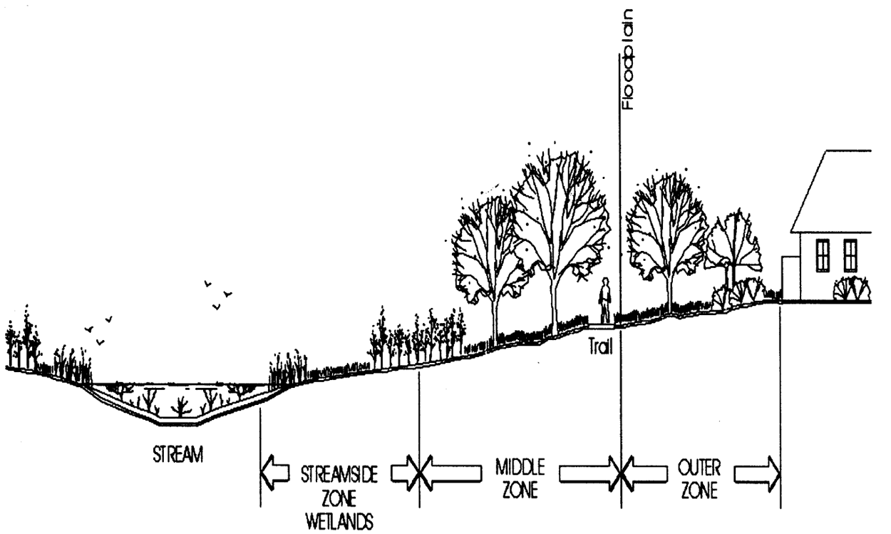
Figure 19-2
Use buffers to protect the physical integrity of riparian ecosystems. Try to preserve vegetation and trees in streamside zone and middle zone. Encourage grass and landscaping in outer zones to filter runoff from backyards, parking areas, roads, etc.
5.
Provide a twenty (20) foot wide minimum area of landscaping as a buffer between nonresidential and residential uses.
6.
Plants shall be selected to blend with the native vegetation for development at the border between developed area and nonirrigated natural open area. Plants with high fuel volume and/or high flammability shall be avoided.
7.
All areas disturbed by construction shall be reseeded to prevent erosion. Native noninvasive grasses shall be used for revegetation where practical.
8.
Use native seed mixes for natural area restoration.
9.
Trees of the Ulmaceae (elm) family and all species of ash (Fraxinus spp.) white, purple, green and their cultivars, shall not be planted with[in] the Lafayette city limits.
e.
Transition landscaping. The property owner shall use trees, shrubs and groundcover as a means of integrating structures within the development site and surrounding area. The size and intensity of plantings shall be appropriate to the size and context of the improvements.
1.
The property owner shall screen adjacent land uses of different intensities through a combination of berming, plantings and fencing. Opaque screening shall be used only when necessary to mitigate the impact of noise, light, unattractive aesthetics and traffic. If a fence is used as screening, then plant material shall also be used, except in industrial zones where a fence may be used alone.
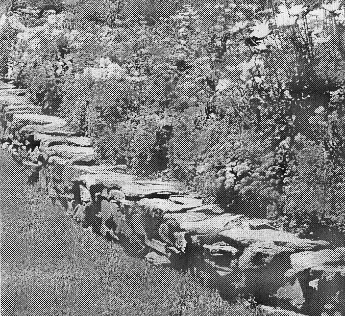
Figure 19-3. Combination of berming, planting and fencing to screen uses
2.
The property owner shall use landscaping to provide a transition from developed, managed landscape to more natural vegetation.
3.
The property owner shall provide a tree canopy by installing shade trees within and adjacent to paved areas.
f.
Plant materials.
1.
The minimum plant sizes on all required landscaping shall be two-inch caliper deciduous trees, one and one-half-inch caliper ornamental trees, six-foot tall evergreen trees and five-gallon shrubs.
2.
Required plant materials shall be grown in a nursery in accordance with proper horticultural practice. Plants shall be healthy, well-branched vigorous stock with a growth habit normal to the species and variety, and free of diseases, insects and injuries.
3.
All plant schedule listings of proposed plant material shall include the respective hydrozone category that reflects the water requirements of that plant. Plant lists with hydrozone categories are maintained in the city's planning and building department.
g.
Guarantee of installation. Required landscape improvements shall be installed prior to issuance of a certificate of occupancy (C.O.) for all structures. The property owner may, in the sole discretion of the city, post a financial guarantee for the improvements equal to one hundred fifteen (115) percent of the cost of improvements. Installation shall then occur within the next planting season. This guarantee shall be released upon completion of the installation of the landscaping.
h.
Maintenance. The property owner shall maintain landscape improvements in good health and attractive condition. All property owners shall be responsible for maintenance of landscaping within the portion of the public right-of-way between the back of the curb or street pavement and their property.
1.
A maintenance statement satisfying the following conditions shall be placed on the landscape plan, stating:
"Landscapes shall be maintained to ensure water efficiency. A regular maintenance schedule shall include but not be limited to checking, adjusting, and repairing irrigation equipment; resetting the automatic controller; aerating and de-thatching turf areas (only if needed); replenishing mulch; fertilizing; pruning, and weeding in all landscaped areas."
2.
The property owner shall maintain the landscaping as approved in the final landscape plan.
3.
The property owner shall provide all regular and normal maintenance of landscaping including weeding, irrigation, fertilization, pruning and mowing necessary to comply with subsections (aa) and (bb) above.
4.
The property owner shall not use plant materials which exhibit evidence of insect, pest, disease, and shall appropriately treat any and all damaged plants, and shall remove and replace any and all dead plant material with living plant materials.
5.
If the required maintenance is not being performed pursuant to the terms of this section, the owner of the property shall be notified in writing of the failure to properly maintain landscaping by certified mail, return receipt requested. The notice shall give the owner not less than five (5) days nor more than ten (10) days in which to bring the landscaping into compliance with this section. In the event that the owner fails or neglects to comply with the above notice, the city planning director may cause the necessary work to be performed and shall make reasonable efforts to notify the owner of the cost thereof plus the charges as authorized in this section; provided that in no event shall failure of the owner to receive notice of the cost and charges void the lien provided for in this section. The actual cost of such work plus fifteen (15) percent for inspection and other costs in connection therewith shall, in the event the payment thereof is not made to the city within thirty (30) days after completion of said work, become a lien against said property as of the date the city treasurer certifies the cost of and charges to the office of the county treasurer for collection in the same manner as general property taxes are collected. The amount of the assessment for the costs and charges provided for in this section may be paid to the city treasurer at any time prior to certification of the same by the city treasurer to the office of the county treasurer, but thereafter payment shall be made only to the office of the county treasurer. In the event any owner desires to object to an assessment made pursuant this section, the owner shall within thirty (30) days after completion of the work on the property file a written objection thereof with the city clerk, who shall thereupon designate the next regular meeting of the city council as the date when said objector may appear before the council and have the objection heard. Upon receipt of the assessment pursuant to this section, the county treasurer shall proceed to collect the amount as assessed and certified against the property affected thereby in the same manner as the collection of the general property taxes and the redemption thereof.
i.
Adjustment of requirements.
1.
The planning director is authorized to allow a variance from the strict application of this section in cases which involve practical difficulties or unnecessary hardship, provided however, that:
i.
The variance granted is the minimum necessary to alleviate such practical difficulties or undue hardship upon the owner of the property;
ii.
Such relief may be granted without substantial detriment to the public good and without substantially impairing the intent and purpose of the general plan of this chapter;
iii.
The circumstances found to constitute a hardship were not created by the appellant, are not due to or the result of general conditions in the district and cannot be practically corrected;
In granting such variance, the planning director may attach thereto reasonable conditions. The grant of any variance shall not constitute or be construed as a precedent, ground or cause for any other variance.
2.
Appeals from this section shall be considered by the zoning board of adjustment pursuant to the provision of this chapter.
(d)
Landscaping minimum requirements.
(1)
Right-of-way. The property owner shall provide:
a.
One (1) deciduous or ornamental street tree for every forty (40) linear feet of street frontage or portion thereof. Street trees shall be planted within the tree lawn portion of the right-of-way with adequate spacing to allow for the mature spread of the trees. When a tree lawn is not provided, trees shall be planted within ten (10) feet of the back of curb.
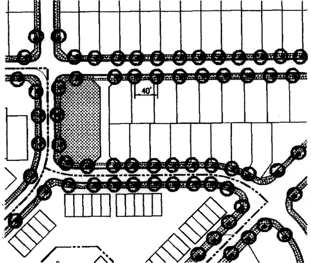
Figure 19-4
Provide one (1) tree for every forty (40) feet of street frontage or portion thereof. Space trees to account for mature spread.
b.
Live groundcover as appropriate to the use and function of the area described in subsection a. above, including grass, trees, flowers, or shrubs. In commercial areas such area may be paved if it functions as pedestrian access to storefronts and is integrated into the overall design of the other improvements on the site.
c.
With the exception of the owners of single family homes, the property owner shall install an automatic irrigation system meeting the requirements of section 26-19-5(c)(1)c. for all landscaping within public rights-of-way.
(2)
Common open area. Landscaping shall be appropriate to the use and function of the area and include trees, shrubs, groundcover, irrigation (where necessary) and paving.
(3)
Single-family residential.
a.
In addition to the right-of-way landscaping described in section 26-19-5(d)(1)a. above, the property owner shall:
1.
Provide landscaping in the front yard of each home. There shall be a minimum of seventy-five (75) percent of the gross front yard area, excluding driveways, landscaped with live materials.
2.
Install landscaping within the side and rear yard and is encouraged to plant additional trees, shrubs and flowers using waterwise principles and the general provisions set forth in this section.
3.
Maintain the landscaping within the adjacent road right-of-way.
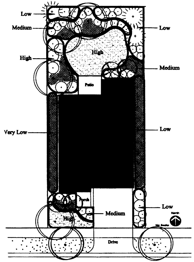
Figure 19-5
Small lot single-family residential landscaping with hydrozone groupings indicated. Provide seventy-five (75) percent minimum live plant materials between front of house and street curb.
(4)
Multifamily.
a.
The property owner shall provide right-of-way landscaping pursuant to section 26-19-5(d)(1).
b.
Landscape improvements shall be designed to enhance the overall appearance of the development and integrate the project with adjacent land uses and the surrounding neighborhood. A minimum of fifteen (15) percent of the gross site area shall be landscaped area. Refer to section 26-20-16(k) for additional landscape requirements.
c.
The property owner shall install site trees, a minimum of one (1) tree per one thousand (1,000) square feet of landscaped area, distributed on the site.
d.
The property owner shall install a minimum of one (1) shrub per one hundred fifty (150) square feet of landscaped area. Shrubs shall be grouped and distributed throughout the site. Trees may be substituted for up to one-half (½) of the required shrubs at the rate of one (1) tree for ten (10) shrubs and vice versa, subject to planning commission approval.
e.
The property owner shall install groundcover, either irrigated turf maintained to appropriate standards for active recreation in active recreation areas, or where appropriate, use native grass for areas that will not function as active recreation areas. Native grass must be weed free and maintained at an appropriate height according to species.
f.
Parking lot landscaping as required in section 26-19-5(d)(6).
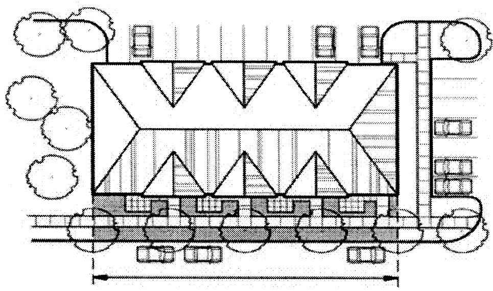
Figure 19-6
(5)
Nonresidential.
a.
The property owner shall provide right-of-way landscaping pursuant to section 26-19-5(d)(1).
b.
Landscape improvements shall be designed to enhance the overall appearance of the development and integrate the project with adjacent land uses and the surrounding neighborhood. A minimum of fifteen (15) percent of the gross site area shall be landscaped area. Refer to section 26-20-16(k) for additional landscape requirements.
c.
The property owner shall provide:
1.
A minimum of one (1) tree per one thousand (1,000) square feet of landscaped area, distributed on the site.
2.
A minimum of one (1) shrub per one hundred fifty (150) square feet of landscaped area. Shrubs shall be grouped and distributed throughout the site. Trees may be substituted for up to one-half (½) of the required shrubs at the rate of one (1) tree for ten (10) shrubs, and vice versa, subject to planning commission approval.
3.
Irrigated grass turf for active recreation areas. Where appropriate, native grass may be used for areas that will not function as active recreation areas. Native grass must be weed free and maintained at an appropriate height for each species.
4.
Parking lot landscaping as required in section 26-19-5(d)(6).
d.
Property owner shall screen industrial and commercial loading areas, including vehicle loading areas, and service and storage areas visible from the public right-of-way or adjacent property, with an opaque screen that is an integral part of the building architecture, by landscaping, or a combination of fencing and landscaping. Chain link fencing with slats, tires or building materials shall not be used as screening materials.
e.
Integrate activities on the subject property with adjacent land uses by utilizing a combination of landscaping, building orientation and appropriate architectural elements.
f.
The property owner shall maintain the yard and landscaping within the adjacent road right-of-way.
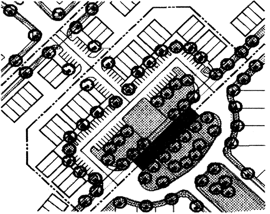
Figure 19-7
Create pedestrian-friendly commercial areas by:
•
Providing open areas for gathering places.
•
Creating a tree canopy between on-street parking and store fronts to provide a separation between cars and sidewalks.
•
Landscaping parking lots.
(6)
Parking lots.
a.
Parking lot landscaping shall break up large expanses of pavement, create shade, buffer views of parking lots from adjacent streets and development, and enhance the overall appearance of each project.
b.
All parking lots with ten (10) spaces or more shall be subject to the requirements of this section 26-19-5(d)(6). Refer to sections 26-20-16(b) and 26-20-16(k) for additional landscape requirements.
c.
The property owner shall provide:
1.
A minimum of one (1) tree per fifteen (15) parking spaces, to be placed in islands which are a minimum of ten (10) feet wide, and shall use the landscaping to break up large expanses of pavement and to create a tree canopy for summer shade. (See Figure 19-8.)
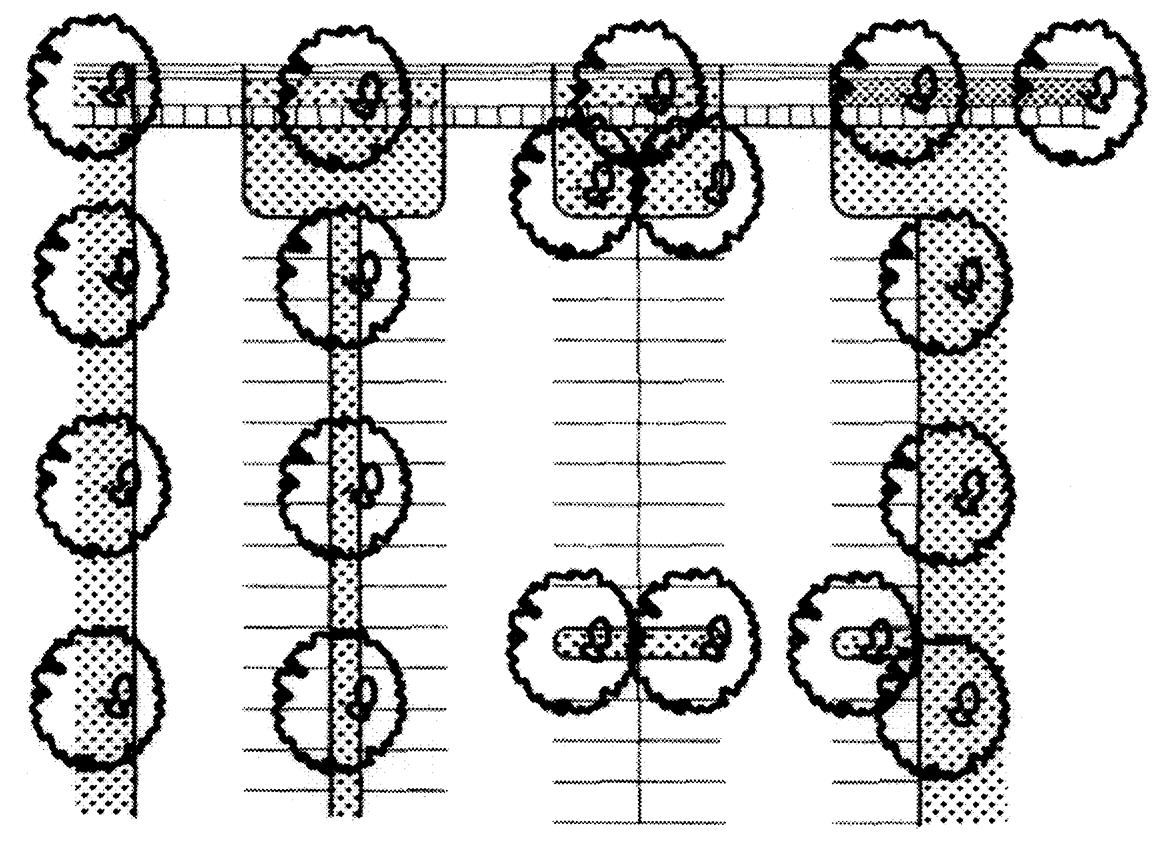
Figure 19-8
Possible configuration of parking lot, with islands.
2.
A minimum of one (1) shrub per parking space, to be grouped in landscape islands or around the parking lot perimeter.
3.
Shrubs and ornamental grasses in areas less than ten (10) feet wide.
4.
A landscape setback to parking lots, twenty (20) feet from arterial street rights-of-way or fifteen (15) feet from any other street right-of-way. The purpose of the setback is to provide a buffer between the street and parking areas and to screen the parking from the street. This setback may be reduced to ten (10) feet if used in combination with a three to four (3-4) foot articulated masonry or stone decorative wall with trees and shrubs on both sides of the wall to soften its appearance.
5.
Plant material intended as buffer shall be planted at a density so as to provide effective screening within two (2) years.
(7)
Stormwater detention.
a.
Intent. To promote innovative and effective land and water management techniques that protect and enhance water quality.
b.
General provisions.
1.
All stormwater detention facilities shall be appropriately landscaped in coordination with the planning director after consultation with the public works director.
2.
Landscaping associated with stormwater detention facilities shall be integrated into the overall design of the project.
3.
Landscaping shall enhance the overall appearance of the project, prevent erosion and improve water quality of storm water runoff whenever possible.
4.
Stormwater detention facilities may function as open area for active recreation, trail corridors or habitat enhancement areas if they are designed appropriately and approved by the planning director after consultation with the public works director.
5.
The use of planting strips and shallow, landscaped depressions in parking lots and along roads is encouraged to help trap and remove pollutants from stormwater runoff.
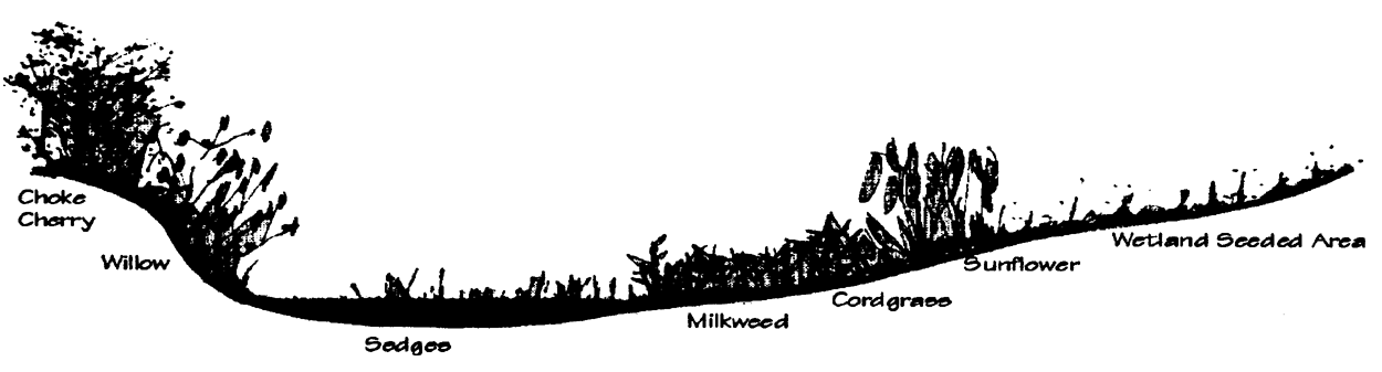
Figure 19-9
Develop storm drainage systems as landscape amenities which can enhance the overall project.
c.
Minimum requirements.
1.
All stormwater detention facilities shall be planted with grass appropriate to the function of the area. Areas to be used for active recreation shall be turf-type grass and irrigated with a permanent irrigation system. Areas to be maintained for habitat enhancement shall be seeded to native grasses and wildflowers. The property owner shall establish a complete, weed free stand of grass. Trail corridors may be seeded with native grasses if appropriately integrated with adjacent improvements.
2.
Landscape improvements shall be designed to enhance the function of the facility. Areas designed for recreation shall include clusters of trees to provide shade, located so they do not impair the function of the facility.
3.
Habitat and water quality enhancement, including wetland plantings in low wet areas is encouraged.
d.
All detention facilities shall be owned and maintained by the property owner unless otherwise approved by the city council.
(e)
Submittal standards for landscape plans. Landscape plans required by Section 26-17 of this chapter shall be submitted in accordance with the following chart:
(1)
Sketch plan. Intent: To illustrate the overall design concept for landscaping and depict how it relates to the overall development.
a.
The landscape sketch plan shall describe the general landscape design intent and the water conservation concept statement of the proposed landscape improvements.
b.
At a minimum, the landscape sketch plan shall include the information as set forth in Table A below.
(2)
Preliminary plan. Intent: To illustrate the master landscape plan for the development.
a.
The landscape preliminary plan shall state how the proposal is consistent with the intent of these regulations, i.e. how it will preserve the city's special character, and integrate and enhance new development by promoting quality landscape design that reinforces the identity of the community and each neighborhood; will provide tree-lined streets in urban areas; will anchor new buildings in the landscape; provide tree canopies within paved areas; will screen adjoining conflicting uses; will screen parking areas, service yards and stormwater management facilities to provide an attractive streetscape; and will be environmentally sensitive by preserving existing trees, uses water conservation techniques, plants native species (when appropriate), and enhances valuable habitat.
b.
At a minimum, the preliminary landscape plan shall include the information set forth in Table A below.
(3)
Final plan. Intent: To ensure each phase of the final landscape plan is consistent with the master landscape plan for the development and to illustrate the specific landscaping details for each phase.
a.
The final landscape plan shall describe the design intention and shall state how the proposal is consistent with this section, and/or with the preliminary landscape plan, if one was required.
b.
The final landscape plan shall be on a separate page from the final plat map. The scale shall not greater than one inch equals fifty feet (1" = 50').
c.
At a minimum, the final landscape shall include the information required in Table A below:
TABLE A
Appendix A. Calculating an Annual Water Budget
An annual water budget is the target maximum amount of water a landowner should use in a typical watering season. This target provides simple-to-achieve, realistic goals for landscape irrigation. Water budgeting focuses less on watering time limits, and is more concerned with a user's water allotment and reducing over-watering. This form can help any user create a target annual water budget from which to work.
The information below will help guide you through the annual water budget worksheet on the following page.
Step 1. Gallons of Water Needed by Plant Category:
Different plants have different water needs. A plant list that identifies the water needs of landscape plants (high, moderate, low, very low) is available in the planning and building department.
Due to variability in plant water requirements due to location of the plant on a site, a range of hydrozone categories has been shown for many plants. For purposes of calculating the water budget for each hydrozone, the lowest hydrozone category for each plant shall be used.
Step 2. Irrigation Areas (Zones) Based on Plant Water Need Category:
Both automatic irrigation systems and hand-placed yard sprinklers deliver water to plants by watering areas or "zones", and have set watering amounts determined by you, the user. If you have high water need plants within low or very low water plant groupings, the entire area must be considered a high-water area and irrigated as such; however some plants may be over-watered if this occurs. The area of each watering zone can be determined by physically measuring the zone, and multiplying length (in feet) by width (in feet). The resulting areas (in square feet, or S.F.) can be entered in Step 3 below.
Step 3. Water-Use Calculations:
Fill in the blanks with area and water need per zone. For example, you might have an area of 300 S.F. in a High Water Zone that would require 20 gallons of water per S.F. After multiplying you would find that area requires 6,000 gallons of water per season.
After calculating the irrigation needs of all areas, determine your average overall water needs per season. To do this, add the total gallons needed for all zones, and divide by the total square footage for all zones. The average for the overall site must be no more than 15 gallons per S.F. per season. If your average is more than this, you must modify your planting layout to create more low/very low water zones that would balance your high/moderate water zones, and reduce over-watering.
Annual Water Budget Worksheet
1. Gallons of Water Needed by Plant Category:
Determine the water needs of the various plants in your design. A plant list that identifies water needs (high, moderate, low, very low) is available at the planning and building department.
Plant Water Need Category Irrigation: Denver
2. Irrigation Areas (Zones) Based on Plant Water Need Category:
Identify each zone requiring irrigation, and calculate the area (in square feet) of each zone. If plants are already installed and/or not grouped together by water need, pick the highest water need category included in each zone.
3. Water-Use Calculations:
*
The average shall be a maximum of 15 gals/S.F./season.
(Ord. No. 2004-1, § 1, 3-2-04; Ord. No. 2005-22, § 8, 8-2-05; Ord. No. 2012-29, § 2, 11-5-12; Ord. No. 2014-14, § 4, 5-20-14; Ord. No. 2019-06, § 3, 2-19-19)
Editor's note— Section 1 of Ord. No. 2004-1, adopted March 2, 2004, repealed and reenacted § 26-9-5 to read as herein set out. Former § 26-19-5 pertained to the same subject matter and derived from Ord. No. 1986-01, adopted Feb. 4, 1986; Ord. No. 1987-17, adopted Aug. 18, 1987; Ord. No. 1988-18, adopted Sept. 20, 1988; Ord. No. 1989-01, adopted Feb. 21, 1989; Ord. No. 1990-4, adopted April 17, 1990; Ord. No. 1998-24, adopted Aug. 18, 1998; and Ord. No. 2001-9, adopted March 20, 2001.
Sec. 26-19-5.1. - Revegetation required.
All land excavations, fills or stockpiles that remain unused for a period of time in excess of thirty (30) days shall be revegetated to assure that dust and debris do not blow off the site and cause a nuisance to surrounding properties.
(Ord. No. 2001-43, § 7, 12-4-01)
Sec. 26-19-6. - Street design.
Construction of streets shall conform to the following design standards and regulations:
(a)
The street pattern shall conform to any transportation plan or comprehensive plan adopted by the city and shall afford safe and convenient access to all lots within the subdivision.
(b)
Streets shall be designed to join with planned or existing streets:
(1)
Intersections of streets shall be at right angles unless otherwise approved by the city engineer.
(2)
No more than two (2) streets shall intersect at one (1) point.
(3)
Two (2) streets meeting a third street from opposite sides shall meet at the same point, or their center lines shall be offset at least three hundred (300) feet.
(c)
Streets shall have the names of existing streets which are aligned in the city.
(d)
Streets which are extensions of existing or platted streets shall bear the same classification as that assigned to the existing or platted street in any adopted transportation or comprehensive plan, and shall conform to any special standards pertaining to such classifications.
(e)
Local residential streets shall be laid out to discourage through traffic, and where a proposed subdivision borders on or includes a street designated arterial, intersections of proposed streets with such arterials shall be held to a minimum. Lots bordering arterial roadways may be either reverse-facing on an interior street within the subdivision, or served by a frontage road.
(f)
Streets shall be designed to bear a logical relationship to the existing topography.
(g)
Deadend streets shall not be permitted. A street may end in a permanent cul-de-sac providing that the street is not longer than five hundred (500) feet and that the radius of the turning area is at least forty-five (45) feet to the curb, and fifty (50) feet to the edge of the right-of-way. Where a street is designed to connect with a future street, a temporary turn-around shall be provided with a radius equal to that required for a permanent cul-de-sac or of an alternate design approved by the city engineer based on the traffic movement generated by the street in question. If the temporary turn-around is to exist or exists for a period longer than six (6) months, then the developer shall pave the temporary turn-around and construct a curb, gutter and sidewalks if so directed by the city engineer. When the connection is finally made, the developer shall be responsible for re-constructing the turn-around area to fit the normal street design, and the city shall reassign the excess right-of-way back to the owners of the adjacent property. Surface drainage on a cul-de-sac shall be towards the intersecting street unless a drainage easement is provided from the cul-de-sac.
(h)
All subdivision streets shall comply with city resolutions, ordinances and regulations which may be adopted and amended from time to time by the city council. Street designs, including pavement width and right-of-way widths shall comply with the minimum width standards of Table 26-E.
(1)
Drainage easements shall be a minimum of ten (10) feet, or larger if required by the city engineer.
(2)
Utility easements shall be ten (10) feet unless otherwise required at a lesser or greater width.
(3)
Half-streets shall not be permitted, except when required to complete a half-street already in existence.
(4)
Minimum street gradient for all streets shall be three-quarters (¾) of one (1) percent. Maximum street gradient shall be eight (8) percent. Streets shall not exceed a gradient of four (4) percent within one hundred (100) feet of an intersection. Vertical curves shall be used at changes of grade exceeding one (1) percent and shall be designed to provide a minimum sight distance of two hundred (200) feet, except for arterial streets which shall be subject to state and federal standards. To ensure adequate sight distance, when street roadway lines deflect more than five (5) degrees, connection shall be made by horizontal curves.
(5)
Where a street classified as arterial intersects with any other arterial street, no on-street parking shall be allowed on the arterial street within one hundred (100) feet of the intersection. If the arterial street consists over its general length of only two (2) traffic lanes, then a third lane shall be provided and stripes painted to the specifications of the city engineer to enable vehicles to make left turns at intersections without impeding other traffic.
(6)
All utilities shall be installed before streets or alleys are surfaced.
(Ord. No. 1986-01, § 2, 2-4-86; Ord. No. 2005-22, § 9, 8-2-05; Ord. No. 2007-15, §§ 6, 7, 4-3-07; Ord. No. 2011-15, § 7, 5-3-11)
Sec. 26-19-7. - Alleys and easements.
Alleys in residential subdivisions are not encouraged. Paved alleys shall be provided in commercial and industrial areas and shall be required unless other provisions are made and approved for service access. Easements for utility purposes shall be required along all side and rear lot lines except those bordering dedicated streets and alleys. Drainage easements shall be designed to accommodate excepted runoff and shall comply with the provisions of section 26-19-9.
Sec. 26-19-8. - Street improvements.
All street improvements are the financial responsibility of the developer, subject to the provisions of section 26-19-6 unless specifically exempted by written agreement with the city council. All streets and alleys proposed for dedication to the public shall be laid out, graded and paved from curb to curb, and painted to the specifications of the city. Curb, gutter and sidewalks shall be installed on all streets unless otherwise approved by city council. In cases where an existing street which has not been brought up to city specifications is located within a subdivision, such street shall be paved and curb, gutter and sidewalk and other improvements shall be installed in order to meet city specifications. If any subdivision is located adjacent to any existing street right-of-way, the developer shall develop such street with improvements as required to bring such street up to city specifications. The developer shall provide and install street signs at all street intersections and traffic control signs as requested by the city traffic engineer. Permanent reference monuments and monument boxes shall be installed by the developer to city specifications, as shall bicycle paths where required by city. Street lights when required by the city shall be installed by the developer.
(Ord. No. 1986-01, § 2, 2-4-86)
Sec. 26-19-9. - Drainage.
Drainage easements and drainage improvements shall be designed by a registered engineer to accommodate expected run-off as determined by the drainage plan. Improvements shall be installed to specifications approved by the city engineer. All drainage improvements described herein shall be the financial responsibility of the developer.
(Ord. No. 1986-01, § 2, 2-4-86)
Sec. 26-19-10. - Water distribution.
The water main distribution system shall be designed to connect with the city water system and make water available to each lot in the proposed subdivision. Fire hydrants shall be located to ensure protection to each lot, but under no circumstances shall a building be located more than two hundred fifty (250) feet in single-family residential areas and one hundred seventy-five (175) feet in multifamily, commercial and industrial areas from the nearest hydrant based on straight line distance. Design of the system shall be the responsibility of the developer and all plans are subject to approval of the city engineer. Installation of the system shall be to city specifications and at the direction of the city council through their designated representatives. Financial responsibility for the water distribution system shall be subject to city regulations and agreements relating thereto between the city council and the developer.
(Ord. No. 1986-01, § 2, 2-4-86)
Sec. 26-19-11. - Sanitary sewage collection.
The sewage collection system shall be designed to connect with the city system and provide service to each lot in the proposed subdivision. Design of the system shall be the responsibility of the developer and all plans are subject to the approval of the city engineer. Financial responsibility for the sanitary sewage collection system shall be subject to city regulations and agreements relating thereto between the city council and the developer.
(Ord. No. 1986-01, § 2, 2-4-86)
Sec. 26-19-12. - General utilities.
All utilities, except major power transmission lines, shall be underground, unless specifically exempted by the city council, who shall grant such exemption only in cases of extreme difficulty.
(Ord. No. 1986-01, § 2, 2-4-86)
Sec. 26-19-13. - Oversize reimbursement.
In the event oversized utilities are required, agreements for reimbursement shall be made, whereby the developer shall be allowed to recover the cost of the utilities that have been provided by him beyond the needs of his development and standard city specification. The method and time of payment shall be established in accordance with the current policies of the city and/or agreement between the developer and city council.
(Ord. No. 1986-01, § 2, 2-4-86)
Sec. 26-19-14. - Sidewalks.
Sidewalks are required on both sides of all streets and shall be at least four (4) feet wide. Residential and collector streets may have mountable curb and gutter and attached sidewalk. Construction of sidewalks shall be to specifications set by the city engineer. All sidewalks shall be ramped at all street intersections or other pedestrian crossing areas.
(Ord. No. 1986-01, § 2, 2-4-86)
Sec. 26-19-15. - Bicycle paths.
Developers shall install a bicycle path at least six (6) feet in width along the right-of-way of any subarterial street and any arterial street which is not bordered by a frontage road. The initial site of the path along any street shall be determined by the city engineer. Each developer who extends the path shall keep the path continuous and with as little change in grade as possible. If topography necessitates that the path change from one side of the street to the other, or if the path intersects with another arterial or subarterial street, crosswalks shall be provided. All bicycle paths shall be ramped at intersections. Paths and crosswalks shall meet construction and design standards set by the city engineer.
(Ord. No. 1986-01, § 2, 2-4-86)
Sec. 26-19-16. - Street lighting.
The developer shall have street lights installed at points designated by the city or public service company. The poles for such lights shall be material approved by the city. The design of both poles and the lights shall meet specifications established by the city engineer.
(Ord. No. 1986-01, § 2, 2-4-86)
Sec. 26-19-17. - As-built plans.
These guidelines shall be used by subdividers, builders and/or others who are required to submit final as-built drawings by the city engineer or by this chapter. The content of these guidelines will be complied with in all cases where applicable, but shall not be construed as being all inclusive.
These are guidelines only and do not in any way relieve subdividers, builders, contractors and/or others of the responsibility to submit as-built drawings that are accurate and complete in detail.
(a)
Pre-final as-builts shall be submitted on completion of all work within a phase of the development, and the final as-built plans shall be received before any certificates of occupancy are issued for the project.
(b)
Pre-final as-builts shall be submitted for review and/or correction. Pre-finals will be a minimum of two (2) blue line prints. One (1) copy will remain on file with the City of Lafayette and one (1) copy will be returned to the parties responsible for any revision.
(c)
Final as-builts will be submitted on mylar and will become property of the City of Lafayette and a part of permanent city records.
(d)
Subdivision as-builts shall show dedicated rights-of-way.
(e)
All sewer and water utility as-builts shall clearly show:
(1)
Inv. in, inv. out, rim elevation on all manholes.
(2)
Location of all valves, manholes, fire hydrants and/or other utilities with at least two (2) ties from discernible objects.
(3)
Distance and slope between manholes shall be noted as offsets to mains from curbs or property lines.
(4)
Dimensions for existing and/or added water and sewer taps from lot corners or readily discernible objects. Sewer taps shall have additional dimensions from the tap to the downstream manhole.
(5)
All dimensions shall be from fixed permanent or readily discernible objects. Where water and sewer taps are located from lot lines, front footage shall be noted from a fixed and permanent point of origin.
(6)
Depth of the lateral or service line shall be noted at the property line.
(Ord. No. 1986-01, § 2, 2-4-86)
Sec. 26-19-18. - Warranty time.
(a)
All public improvements shall have a three-year warranty time, beginning on the day that the city has made an initial inspection and found that all public improvements, including but not limited to streets, utilities and fiber optic conduits, to the extent that such conduits are to be owned and maintained by the city, except the final one and one-half (1.5) inch top lift of asphalt, have been installed to city specifications. Ten (10) percent of the total value of the escrow, letter of credit or other financial guarantee provided to the city pursuant to section 26-17-6(b)(5) of this Code shall be retained by the city during the warranty period. The final one and one-half (1.5) inch top lift of asphalt paving shall be installed only after the construction of all structures that may be built within a subdivision or particular filing thereof is complete or after the initial three-year warranty period has expired, whichever is last to occur. After the expiration of the three-year warranty period, the city engineer may, at his discretion, approve the construction of the final one and one-half (1.5) inch top lift of asphalt on a street-by-street basis upon finding that substantially all of the structures have been built, the occupants of which are likely to use the street in question. The final one and one-half (1.5) inch lift of asphalt shall also have a three-year warranty period for which ten (10) percent of the total value of the escrow, letter of credit or other financial guarantee applicable to the one and one-half (1.5) inch lift shall be retained by the city during the warranty period. The subdivider/developer shall be responsible for requesting an initial inspection of all public improvements to begin the warranty period, and a final inspection of all public improvements at the end of the three-year warranty period. At the subdivider's/developer's request, the city engineer shall make an inspection of the public improvements. When the city engineer finds that the public improvements meet city standards, the city engineer or public works director shall, by way of a written letter to the subdivider/developer, acknowledge the acceptance of the public improvements and authorize the reduction or elimination of the escrow, letter of credit or other financial guarantee, which shall occur after the three-year warranty period. Any repairs to or replacements of public improvements made by the subdivider/developer at the end of the three-year warranty period, including but not limited to repairs or replacements necessitated by damage due to construction traffic or activities, shall themselves be warranted for a period of three (3) years from the date of repair or replacement and an escrow, letter of credit or other financial guarantee acceptable to the city attorney shall be provided to the city, in an amount equal to ten (10) percent of the value of such repairs or replacements, for such three-year period.
(b)
The city council hereby ratifies and affirms all previously approved escrows, letters of credit or other financial guarantees for public improvements along with any development agreements, requirements or any conditions of approval heretofore entered into by the city and expresses its intent that the adoption of this section not affect the validity of such preexisting contracts, requirements or conditions.
(Ord. No. 1986-01, § 2, 2-4-86; Ord. No. 1999-40, § 1, 10-19-99; Ord. No. 2007-15, § 8, 4-3-07)
Sec. 26-19-19. - Land dedication, general requirements.
Every annexation, subdivision or residential or commercial development shall require the dedication of certain sites for parks and recreation use, and may require reservation of sites for school and other public purposes. Land dedicated may include the one hundred year floodplain, national and state historical or natural features, and proposed public areas set aside in state, regional, county or city comprehensive plans. Land dedicated shall not include sites for technical, private or public schools sites, public agencies, sites for service organizations which are not open to the general public, and sites unsuitable for public use due to steep slopes, rock formations, adverse topography, utility easements, or other features which may be harmful to the health and safety of the public.
These requirements shall not apply in cases where dedication arrangements were made and approved by the city council at the time of annexation or previous subdivision of the property.
(Ord. No. 1986-01, § 2, 2-4-86)
Sec. 26-19-20. - Method and amount of land dedicated.
(a)
The subdivider/developer of residential property shall convey to the city, by means of a final plat dedication or deed land to be used for public recreation at locations designated by the city in the following manner: The subdivider shall dedicate fifteen (15) percent of the total land area to the city, except in cases where satisfactory dedication arrangements were made and approved by the city council at the time of annexation and/or prior subdivision.
(b)
In the case of commercial and industrial development, the subdivider or developer shall dedicate and convey to the city by means of final plat dedication or deed, at locations designated by the city, twelve (12) percent of the total gross lot area to be used as public recreation.
(c)
A minimum of eighty (80) percent of land dedicated shall lend itself to utilization for public recreation purposes which include, but are not limited to, the following: playfields, tennis courts, and picnic sites.
(Ord. No. 1986-01, § 2, 2-4-86; Ord. No. 1991-31, § 7, 11-19-91; Ord. No. 2017-4, § 1, 3-7-17)
Sec. 26-19-21. - Credit for private recreation facilities.
The city may give the subdivider or developer credit for private recreation facilities in the development, provided that:
(a)
The amount of land to be dedicated may be reduced by no more than fifty (50) percent of the requirements of this chapter. No portion of the land credit will be given for required drainage detention areas.
(b)
The city council determines that the private recreation facilities offered will absorb a major portion of the recreational demands of the residents or employees of the proposed development.
(c)
The private recreation facilities will be constructed at the same time as or prior to the housing, industrial or commercial facilities in the development.
(d)
There are sufficient guarantees in the development agreement to ensure that the private recreation facilities are completed at the same time as or before the remainder of the development.
(Ord. No. 1986-01, § 2, 2-4-86)
Sec. 26-19-22. - Cash payment in lieu of dedication.
(a)
If the city council, in its sole discretion, determines that there is insufficient, suitable land available within the subdivision to meet the dedication requirement of section 26-19-19 of this chapter, the subdivider or developer shall be required to pay to the city cash, or transfer other suitable property, in lieu of land dedication requirements. Such cash payment shall be in an amount equal to the fair market value of the property that was to be dedicated pursuant to section 26-19-20 of this chapter. If the city council determines to accept other property instead of, or as a partial payment toward the cash payment hereunder, the fair market value of the other property shall be used as the basis of the satisfaction of the requirement.
(b)
A payment in lieu of land dedication shall be made prior to final approval of the subdivision, and such payment shall be used for the acquisition of land and for the improvement of parks, playgrounds and recreation areas in the city, which may benefit the residents of the city in general, as well as those of the proposed subdivision.
(Ord. No. 1986-01, § 2, 2-4-86; Ord. No. 2007-38, § 1, 9-4-07; Ord. No. 2017-4, § 2, 3-7-17)
Sec. 26-19-22.1. - Land dedication deferral.
The payment of all fees and costs and the accomplishment of certain actions contained within sections 26-19-19 through and including 26-19-22 may be deferred pursuant to Article XIV of Chapter 30 of this Code.
(Ord. No. 1990-17, § 21, 8-21-90)
Sec. 26-19-23. - Reservation of land for schools and other public agencies.
(a)
If requested by a public agency, the city council may require a subdivider or developer to reserve land areas sufficient for development of public schools or other public agency facilities. A public agency includes the State of Colorado and any political subdivision thereof.
(b)
Land reserved shall, by the nature of its natural topography, soil condition and connecting utilities, lend itself to development of the desired facility.
(c)
Land reserved shall be purchased by the public agency at its fair market value according to the following schedule:
(1)
Within ninety (90) days following approval of the final plat, the requesting agency and the subdivider or developer shall enter into an option agreement for a period of no greater than one (1) year, with a renewal provision for one (1) additional year, unless other terms are mutually agreed upon between the developer and the requesting agency.
(2)
When the option is signed, the public agency shall deposit with an escrow agent an amount which shall be determined by the public agency and the developer to equal the actual costs and expenses of replatting the subdivision if the option is not exercised, plus ten (10) percent. In the event the public agency and developer cannot agree upon the estimated expenses, the city administrator shall make the determination. In the event the option is extended for an additional year, the public agency shall deposit an additional ten (10) percent of the estimated costs and expenses with the escrow agent.
(3)
For the purpose of this section, the fair market value of the land reserved shall be the value of the raw, undeveloped land, plus a proportionate share, as they benefit the reserved land, of the actual cost of the improvements required of the subdivider or developer.
(4)
In the event the public agency and the subdivider or developer cannot agree as to the fair market value, the parties shall submit the matter to binding arbitration, under such rules and regulations as prescribed by the American Arbitration Association.
(Ord. No. 1986-01, § 2, 2-4-86)
Sec. 26-19-24. - Public art in lieu of fee.
A subdivider or developer may, pursuant to section 28-34, propose to provide public artwork within their subdivision, development or elsewhere in lieu of paying the public art fee that would otherwise be payable pursuant to chapter 28.
(Ord. No. 2005-18, § 1, 6-7-05; Ord. No. 2011-33, § 10, 9-20-11; Ord. No. 2025-25, § 17, 11-18-25)
Sec. 26-19-25. - Refuse, waste, and recycling collection area.
Every development shall provide one (1) or more areas for refuse, waste, and recycling receptacles for solid waste collection, except single-family detached development or multifamily development where there are no central or communal refuse, waste, and recycling collection or storage facilities, and where refuse, waste, and recyclable materials are stored and collected on an individual unit basis. Where such refuse, waste, and recycling receptacles are required, the receptacles shall be located to facilitate collection and minimize negative impacts on public rights-of-way, adjacent properties, and within the development.
(Ord. No. 2005-22, § 1, 8-2-05)