San Marcos City Zoning Code
CHAPTER 20
260 - RIDGELINE PROTECTION & MANAGEMENT OVERLAY ZONE
Section 20.260.010 - Purpose of Chapter
The purpose of this chapter is to preserve primary ridgelines in their natural state and minimize visual impacts to secondary ridgelines through a Ridgeline Overlay Zone (ROZ) and Ridgeline Development Permit (RDP) to protect natural viewsheds and unique natural resources, minimize the physical impacts to ridgelines, and establish innovative site and architectural design standards. In adopting the ROZ, it is the desire of the City Council to have as little financial impact as possible on single-family home property owners while still meeting the intent of the Zone.
Section 20.260.020 - Identification of Primary and Secondary Ridgelines
Primary and secondary ridgelines are identified in North City Area #1, Southeast City Area #2, and Southern City Area #3 within the City limits as of February 14, 2006; delineated in Figures 20.260-1, 20.260-2, and 20.260-3; and shown as bold lines for primary ridgelines and dashed lines for secondary ridgelines on each applicable area map, as described below:
A.
North City Area #1 (Figure 20.260-1) is located in the College Area Community Plan and Twin Oaks Valley Community, which includes portions of "P" Mountain and Owens Peak.
B.
South East and West City Area #2 (Figure 20.260-2) is located in the Questhaven/La Costa Meadows Community Plan, which includes Franks Peak and Mount Whitney (located in San Diego County). This area also includes Double Peak and Cerro de Las Posas as defined by the San Elijo Hills Specific Plan.
C.
Southern City Area #3 (Figure 20.260-3) is located in the Questhaven/La Costa Meadows Community Plan, which includes a southerly primary ridgeline extending from east to west near the San Marcos abandoned landfill.
Figure 20.260-1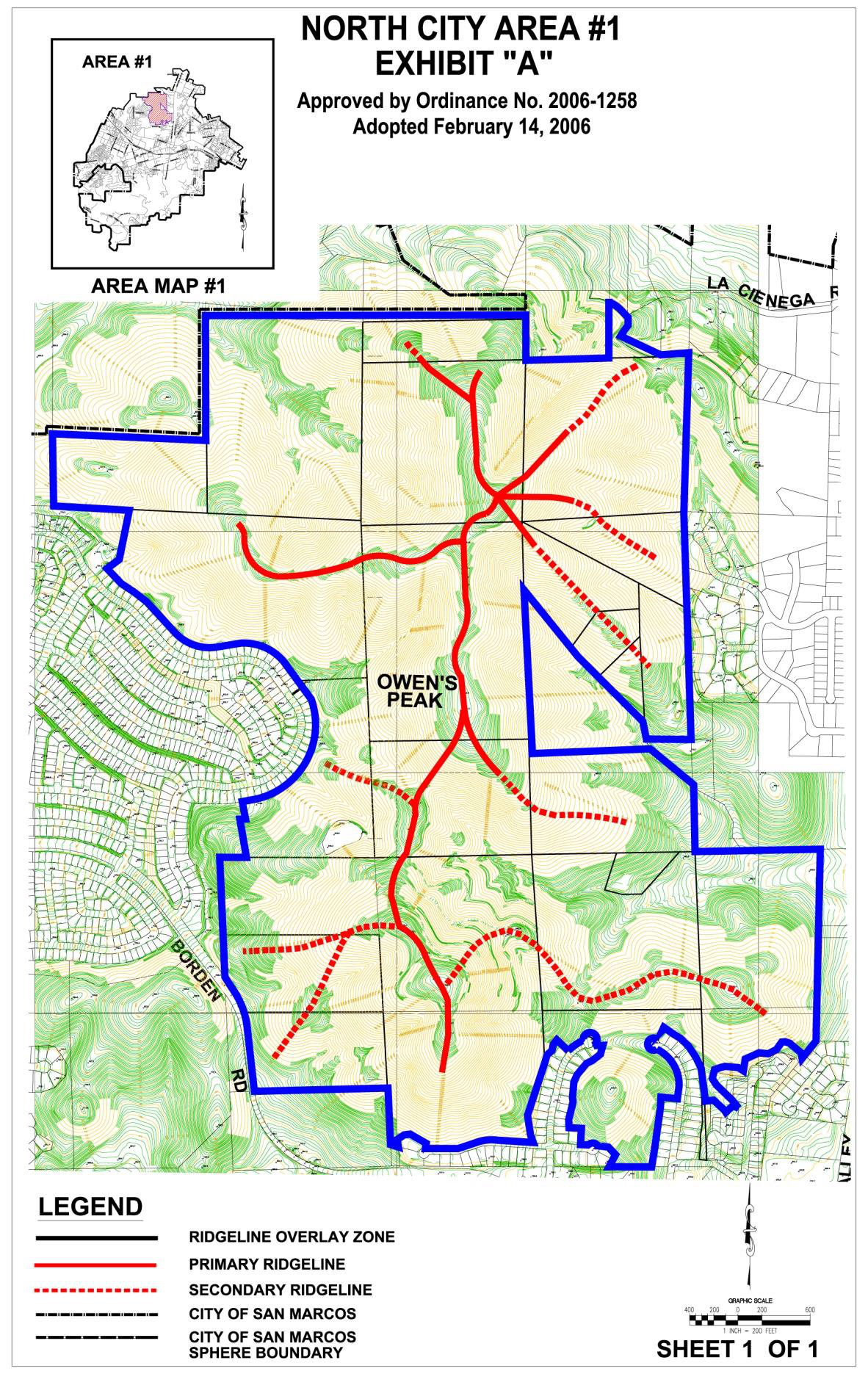
Figure 20.260-2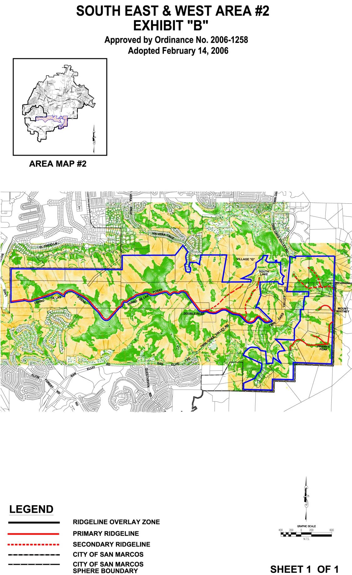
Figure 20.260-3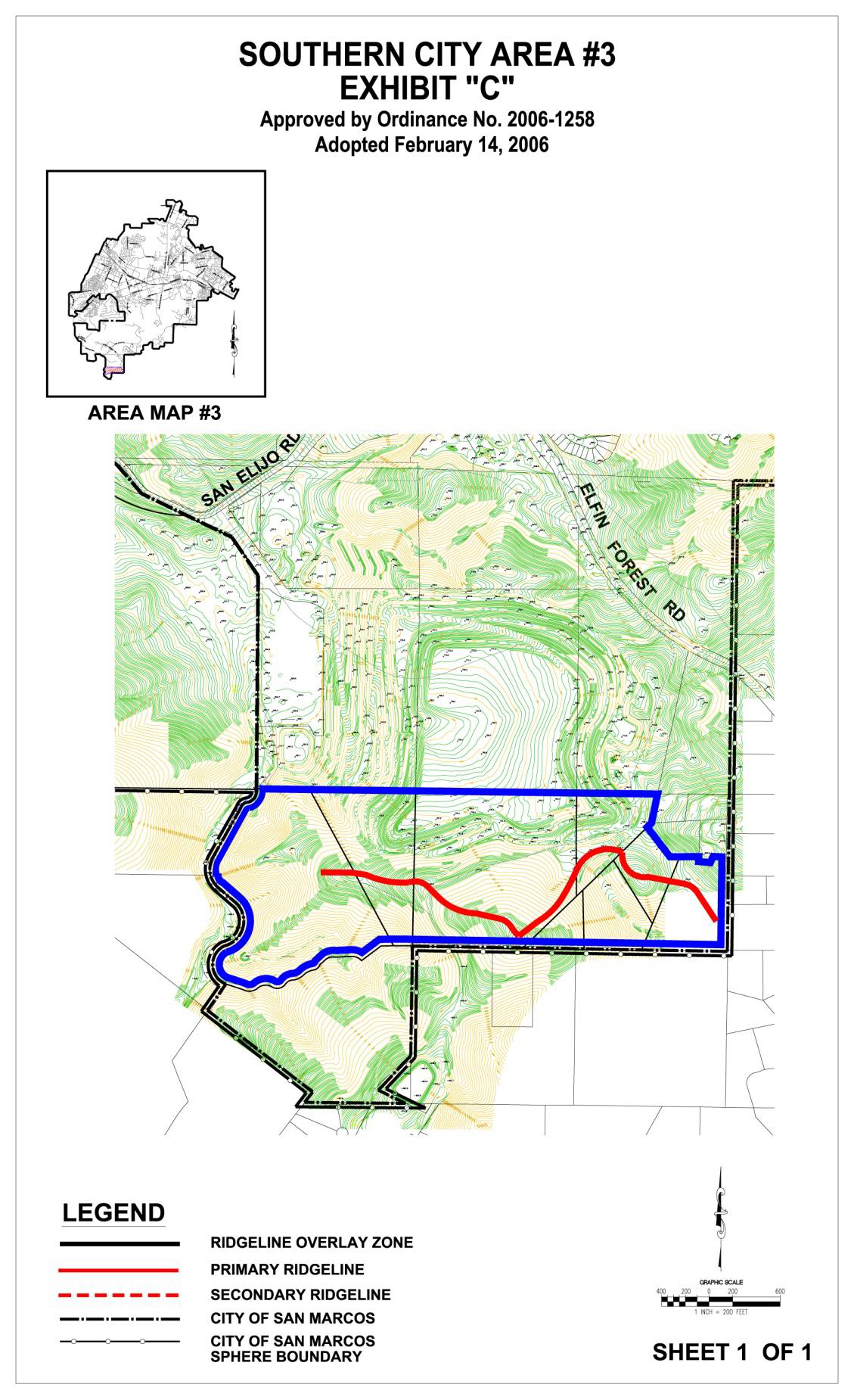
Section 20.260.030 - Applicability and Exemptions
This chapter applies to existing residences, existing permitted uses, and entitled projects as of February 14, 2006, that are located inside the ROZ. Exemption from the requirements of this chapter does not exempt any project or parcel from Code or regulatory requirements. The following projects, permits, and permitted uses shall be exempt from the requirements of Chapter 20.260 (Ridgeline Protection & Management Overlay Zone):
A.
Existing Development. Existing development entitlements such as General Plan Amendments, Specific Plan Amendments, Master Tentative Maps, Final Maps, Site Development Plans, and grading and/or building permits that were issued prior to February 14, 2006, are exempt from this chapter 20.260, provided that either of the following occurs:
1.
No permit, map modification, or change in use is proposed after February 14, 2006; or
2.
A permit or map modification is proposed where it is deemed in substantial conformance, as determined by the Director, with the previously approved permit or map.
B.
Existing Residences. Existing residences located outside of the vertical ridgeline setback are exempt from this chapter, provided the following occurs:
1.
No expansion or modification of the primary residence would require an RDP.
2.
Architectural elements, including decks, trellises, and other similar architectural enhancements that do not increase the building or roofing square footage and do not exceed a maximum building height of twenty-eight (28) feet.
3.
An expansion is proposed provided that expansion does not exceed 1,000 square feet of additional building footprint and that the total combined square footage does not exceed 4,500 square feet maximum or a building height of twenty-eight (28) feet.
C.
Existing Primary Residences. Existing primary residences located within the vertical ridgeline setback are exempt from this chapter, provided the following occurs:
1.
No expansion or modification of the structure is proposed.
2.
Architectural elements, including decks, trellises, and other similar architectural enhancements, are proposed that do not increase the building footprint and do not exceed a building height of twenty-four (24) feet.
3.
An expansion is proposed provided that the expansion does not exceed five hundred (500) square feet of additional building footprint, create a new building footprint exceeding 3,000 square feet, or exceed a building height of twenty-four (24) feet.
D.
Damaged Existing Residences. Existing single-family residences damaged or destroyed by natural disasters (i.e., fires, earthquakes, landslides) can be replaced as previously built; fees will be limited to building/grading permit processing fees.
E.
Other Exemptions. Other existing development-related features and activities:
1.
View fences (wrought iron, plexi-glass) not exceeding a height of six (6) feet.
2.
Construction and/or maintenance of local public streets or private roads necessary for access, including emergency fire access, to the development site or home site.
3.
Public trails for passive recreational use according to an adopted Master Trails Plan.
4.
Public and private utility systems.
5.
On-site waste disposal systems and water storage tanks.
6.
Grading or road construction necessary to maintain a road surface or repair a slope or road failure if such action is deemed necessary by the City Engineer to maintain access or for an emergency (i.e., a situation where life and/or property are threatened). Such actions might include buttressing or repairing a slope failure above or below a structure; repairing access roads; resurfacing an asphalt road; or repairing roadway damage due to erosion, slope failure, or mud slides.
7.
Ongoing or expansion of existing agricultural uses where such expansions do not require grading or construction of structures within the ROZ.
8.
Existing accessory structures.
9.
New accessory structures that do not exceed two hundred (200) square feet in building footprint or a building height of twenty-four (24) feet.
10.
Expansion of existing or approved accessory structures that do not exceed two hundred (200) square feet of additional building footprint or a building height of twenty-four (24) feet, or create a new building footprint exceeding four hundred (400) square feet.
Section 20.260.040 - Permitted and Prohibited Land Uses
Permitted and prohibited land uses in primary and secondary ridgelines in the ROZ are described in Table 20.260-1.
Table 20.260-1
Land Uses in Primary and Secondary Ridgeline Areas
Section 20.260.050 - Development Regulations within the Ridgeline Overlay Zone
A.
Determination of Development Yield. The determination of development yield shall comply with the City's Slope Density Formula, even with clustering through a Specific Plan and the allowable density that is consistent with the General Plan designation and underlying Zone.
B.
Lot Size/Configuration. Lots shall be designed to avoid impacts to primary ridgelines and to preserve secondary ridgelines to the greatest extent practicable. The creation of new residential lots, including residential subdivisions, and adjustments of residential lot lines shall comply with the following standards:
1.
Clustering shall be permitted for a residential development consisting of five (5) residential lots or more through a Specific Plan.
2.
Clustered residential development shall be allowed through a Specific Plan where appropriate and to the extent feasible as a means to preserve the natural appearance of hillside areas. Under this concept, dwellings shall be located in the more level portions of the site, while steeper areas shall be preserved in a natural state. Lots developed through clustering may be smaller in size than would be allowed by the underlying Zone, so long as the following occurs:
a.
The resultant development generally retains the architectural mass, bulk, and scale of surrounding/existing development.
b.
The resultant development preserves, as much as feasible, other environmentally sensitive areas or habitat on-site.
3.
In cases where clustering is not used, lot sizes shall be consistent with the minimum lot size permitted under the Zone per Section 20.300.040 (Gross Slope/Acreage Analysis).
4.
Lots shall be created that are consistent with and conform to the existing City Subdivision Ordinance and ensures that such lots are physically suitable to the existing site topography, geology, and biology, and is feasible for site development.
C.
Circulation. Where feasible, street and driveway layouts shall follow the natural contours of the terrain to minimize grading and visual impacts. The following street and driveway designs may be considered, subject to approval by the City Engineer and the Fire Marshal.
1.
Cul-de-sacs, split-level roads, and loop roads where appropriate to fit the natural topography.
2.
Narrower street sections shall be allowed to minimize grading, habitat removal, and visual impacts.
3.
In ROZ areas with light pedestrian traffic or single-loaded streets, sidewalks installed on only one (1) side of the street shall be allowed.
4.
Improvements necessary to provide for safe, convenient pedestrian access to schools, parks, and other recreational facilities.
D.
Grading/Landform Modification.
1.
Volume of grading.
a.
To the extent feasible, the volume of earth moved for cuts and fill shall be minimized.
b.
Cuts and fill in excess of twenty (20) feet in depth are discouraged.
c.
Grading shall be limited to no more than twenty-five percent (25%) of the lot area.
2.
Screening of manufactured slope.
a.
Hillside development should vary the location and design of structures, landscaping, and access to give a more natural appearance, follow the natural contour of the land, and limit land alteration.
b.
Berms shall be used at the top of slopes and other locations to screen, vary profile, and ensure drainage away from slopes.
3.
Building pads, driveways, roads, and structures, including recreational courts and accessory buildings, in hillside development areas shall follow and avoid significantly altering the natural contour of the land.
4.
Contour grading.
a.
Cut and fill slopes shall be contoured to be compatible with the existing natural landforms. Continuous unbroken slope surfaces that are visible from off-site are discouraged.
b.
Graded slopes should be contoured by varying slope increments and undulating banks vertically and horizontally.
c.
Cut and fill banks and drainage terrace spacing shall be varied to alleviate monotony and allow random landscaping.
E.
Building Placement, Maximum Building Height, and Basements.
1.
In areas adjacent to ridgelines or in moderate slope areas, dwelling units and structures should be sited to do the following:
a.
Use the natural ridgeline as a backdrop for structures.
b.
Use landscape plant material that blends with the adjacent natural vegetation as a backdrop.
c.
Use structures to maximize concealment of any cut slopes.
d.
Locate structures in the most accessible, least visually prominent, and most geologically stable portion or portions of the site.
e.
No new main or accessory structure shall be constructed within:
i.
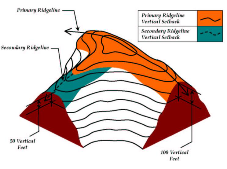
the one hundred (100)-foot vertical contour setback of a primary ridgeline, or
ii.
the fifty (50)-foot vertical contour setback of a secondary ridgeline
Unless it can be proven through computer/photo simulation that each development is consistent with the objectives of this Zoning Ordinance, cannot be seen from the identified viewing platform locations or does not adversely affect the ridgeline silhouette, and is approved by the Planning Commission under Section 20.260.080 (Development Regulation Modification). Additionally, the structure shall not exceed a height of twenty-four (24) feet.
f.
Design dwelling units and structures to incorporate hillside adaptive features such as split-level pads or single-story dwellings.
g.
Exposed basement or stem walls shall be architecturally enhanced and shall be included in the overall measurement of the maximum allowable height from finished grade to the top of the roof pitch.
h.
Build new structures or room additions to not exceed a height of twenty-eight (28) feet.
i.
Locate buildings and improvements to minimize visual impacts.
j.
Allow the option of development to soften or eliminate off-site visual impacts from viewing platforms through ridgeline re-creation, berming, and landscaping.
F.
Architecture. The primary structures shall be designed as follows:
1.
Sensitive architectural design shall be applied. Buildings and improvements shall be scaled to be compatible with the hillside and to avoid excessively massive forms that dominate views of the hillside.
2.
Building facades shall have varying vertical planes, and overhangs shall be used as a means to create changing shadow lines to reduce the visual mass of forms. Buildings shall be stepped to follow the natural contour of the slope and to minimize building heights.
3.
Wall surfaces that are visible shall be minimized in scale through such design features as the use of single-story elements, setbacks, low roof pitches, and landscaping.
4.
Roof pitches shall be generally designed to follow the angle of the site slope, but variation may be provided to avoid a monotonous appearance. Flat roofs are prohibited.
5.
Structures with visible underpinnings that extend more than six (6) feet above grade shall be avoided. Integrate structural underpinnings for decks, additions, or foundation structures that exceed six (6) feet in height into the design aesthetics of the building.
6.
No above ground swimming pools will be allowed unless there are architectural features added to the exposed wall; in-ground pools must meet all code requirements. The exposed wall of a vanishing-edge pool shall be constructed with a stone veneer.
7.
Mechanical equipment shall be screened by a structure or landscaping.
G.
Accessory Structures. (Ord. 2017-1445, 7/11/2017)
1.
Existing accessory structures greater than four hundred (400) square feet will be allowed a twenty-five percent (25%) maximum expansion provided they comply with the regulations stated herein.
2.
The size of the accessory structure or accessory dwelling unit shall be regulated by Chapter 20.410 (Accessory Units and Accessory Structures), and the structure location shall blend with the main dwelling unit while requiring the least amount of grading as feasible.
3.
No temporary or portable car covers or car tents shall be allowed.
4.
Accessory structures shall comply with Chapter 20.410 (Accessory Units and Accessory Structures).
H.
Color and Materials. Exterior finishes and colors of structures and walls shall blend with the color tones of the natural surroundings through the use of earth tones and the avoidance of reflective or bright materials and finishes. The following standards shall also apply:
1.
Exterior finishes, walls, and roof colors should emulate the colors of the surrounding native vegetation and soils. Darker, flatter tones and earth tones, such as browns, greens, and terra cotta, shall be used for exterior siding and roofs. Reflective and bright colors shall be avoided.
2.
Exterior finishes, walls, and roofs shall be a mix of rough textures to blend with the coarseness of the natural surroundings. Materials may include stone, stucco, wood, earth-tone brick, low reflective glass, and integrated color coarse block. Highly reflective glass and polished metal surfaces shall be avoided. Use materials that will reduce light reflection.
3.
The facade of retaining walls shall incorporate architectural enhancements to blend with the natural surroundings.
I.
Walls and Fences.
1.
Fiberglass sheeting, galvanized chain-link fence with inserts, bamboo sheeting, or other similar temporary material shall not be permitted as a fencing material.
2.
Wrought-iron fencing, dark green or black vinyl-clad, chain-link fencing without inserts/slats, or suitable alternative shall be permitted.
3.
Electrified, razor, or concertina wire fencing is prohibited.
4.
Tall and/or elongated retaining walls shall be avoided. Retaining walls higher than eight (8) feet (unless used as part of the structure as a stem wall) shall be divided into terraces and landscaped to reduce their visual prominence.
J.
Fire Fuel Modification.
1.
Fire Clearance:
a.
Buildings should be setback a minimum of twenty (20) feet from down slopes.
b.
A one hundred fifty (150)-foot clearance, or as approved by the Fire Marshal, shall be provided from all structures with vegetation, as approved by a specialized study.
c.
Roofs, overhangs, undersides of exposed balconies, and roof eaves shall be protected with fire-resistant material.
2.
Fire Fuel Management:
a.
New plantings shall feature fire- and drought-tolerant species.
K.
Landscaping.
1.
Retaining walls shall be covered in stone veneer or camouflaged with native landscaping or planted as approved by a fire fuel management plan.
2.
All graded slopes and manufactured open space shall be irrigated and landscaped as approved by the City.
3.
Properties required to use landscaping as a screening method will be allowed to plant so that views are preserved in conjunction with adequate screening.
4.
Larger tree specimens may be required for immediate screening results. Trees shall be selected and placed on property so that trees do not impact the silhouette or skyline of the ridgeline as they mature.
5.
Planting of native landscape shall be used to camouflage visible structures as required by the Director.
L.
Interface with Biological Reserves/Subarea Plan (Focused Planning Areas) Preserved Design. All development within the ROZ shall be consistent with the City's Multiple Habitat Conservation/Subarea Plan.
M.
Exterior Lighting. Exterior lighting shall be the minimum necessary to provide adequate illumination of pathways, entryways, and private outdoor areas. Lighted outdoor recreational facilities, including basketball, tennis, and volleyball courts, and athletic fields may be permitted under a DP. The following standards shall also apply:
1.
Flood lighting shall be prohibited.
2.
Outdoor lighting, including street lighting, mounted light fixtures, and landscape lighting shall use full cut-off light fixtures. Light fixtures shall be shielded so that the illuminated area does not extend beyond the property boundaries.
3.
Site and building design shall incorporate low-intensity exterior lighting.
4.
The use of ground-level fixtures is encouraged. Taller, more visible fixtures shall be avoided.
N.
Findings. Projects of two (2) or more dwellings units shall comply with the required findings:
1.
Conforms to the General Plan.
2.
Can be adequately, reasonably, and conveniently served by public services, utilities, and public facilities.
3.
Undevelopable areas of the project pursuant to Section 20.260.020 (Identification of Primary and Secondary Ridgelines) of this Zoning Ordinance, have been properly identified.
4.
Complies with the purpose and intent provision of Section 20.260.010 (Purpose of chapter) of this chapter.
5.
Substantially conforms to the ridgeline development guidelines.
Section 20.260.060 - Ridgeline Development Permit and Noticing
The regulations of this chapter are intended to streamline development and protect visual aesthetics of the ridgeline.
A.
Ridgeline Development Permit (RDP) Required. The proposed construction of two (2) or more main structures or parcels located within a primary or secondary ridgeline setback area that involves grading, or construction into or onto the areas identified as the City's ROZ Map must obtain an RDP pursuant to this chapter prior to any construction. The Development Regulations herein shall apply to subdivisions, uses, new structures, and additions to existing structures including accessory structures and to all development on a parcel(s) located within any ROZ.
B.
Ridgeline Development Permit Exemption. The proposed construction of one (1) single-family residence, on a legal lot in the ROZ, that conforms to the regulations of this chapter shall not be required to obtain an RDP. Noticing, consistent with Section 20.260.060.D, shall occur based on receipt of the building plans submitted by the property owner.
C.
Required Review. The RDP and submitted building plans must be reviewed and approved by the Planning Commission.
D.
Noticing. Within twenty (20) working days of the receipt of the RDP (or receipt of the building plans) by an applicant, the San Marcos Planning Division shall:
1.
Mail out a Notice of Intent (NOI) to the surrounding property owners within 1,000 feet of project boundary; or expand the NOI to include a minimum of one hundred (100) property owners, whichever is greater.
2.
Post the NOI on the City's website.
Section 20.260.070 - Application Submittal Requirements
Application for an RDP shall be made in accordance with the procedures set forth in this section.
A.
Chapter Compliance. Although an RDP is not required for a single lot proposing a single-family dwelling unit or accessory structure, the applicant shall conform to the design and development standards in this Zoning Ordinance prior to approval of a building permit.
B.
Filing. An application for an RDP may be made by the record owner or owners of the property affected or authorized agent of the owner or owners. The application shall be filed with the Planning Division upon filing forms required by the Planning Division. The application shall be accompanied by the requirements listed under Section 20.260.070.D, which allow for detailed review pursuant to this chapter and demonstrate compliance with this Zoning Ordinance.
C.
Noticing and Fee. At the time of filing the RDP application, which will include a Public Notice procedure consistent with that described in 20.260.060, above, the applicant shall pay a processing fee as established by the City plus appropriate environmental fees.
D.
Submittal Requirements. The required submittal of plans and material are as follows:
1.
Legal description, Assessor's Parcel Number, and vicinity map.
2.
A brief outline of proposed project.
3.
A description of and zoning of adjacent properties.
4.
Photographs of site.
5.
An existing conditions map showing all trees, shrubs, vegetation, rock outcroppings, ridges and hilltops, drainage courses, lakes, ponds, access points, easements, existing buildings, proposed buildings, above-grade utility lines, buildings on adjacent lots within fifty (50) feet of the project property line, and any other significant natural features.
6.
A slope map with a minimum two (2)-foot contour interval at a scale of one (1) inch = one hundred (100) feet clearly depicting all contours on-site. In cases where applicant may rely on an off-site easement for brush management and access, show all slopes in these areas as well.
7.
A preliminary soils report submitted by a certified engineer.
8.
A preliminary hydrology report.
9.
An erosion control plan.
10.
Grading and drainage plan, if applicable.
11.
Fuel Management Plan.
12.
A landscape plan.
13.
Plans and elevation or rendering of proposed dwelling and other buildings.
14.
Samples of the proposed building material on a material board.
15.
A photo simulation may be required for subdivisions of five (5) or more lots, or as determined by the Director. The simulation should be taken from off-site viewing platforms and showing the relationship between the Primary/Secondary Ridgeline versus the proposed development as determined by the Director. Minor subdivisions may still require, at a minimum, visual cross-sections as determined by the Director.
16.
Other technical studies addressing visual and design aspects of the project as deemed necessary by the Director.
Section 20.260.080 - Development Regulation Modifications
When the strict literal interpretation and/or enforcement of the provisions of this chapter creates practical difficulties or results that are inconsistent with the goals and purposes of the ROZ, a modification of the applicable development regulations and/or required setbacks may be granted in accordance with the following.
A.
Request for Modification Procedure. The variance procedure established by Chapter 20.525 (Variances) of this Zoning Ordinance, including noticing and appeals procedures, shall be applicable to the modification of development regulations within the ROZ. However, for any ROZ modifications the Planning Commission shall have final review and approval responsibilities, subject to the following finding requirements in place of those findings required by Section 20.525.040 (Required Findings).
1.
The visual impacts of the proposed development have been minimized through creative or innovative design.
a.
A photo simulation, acceptable to the Director, of the proposed development (exempting single-family units in compliance with this chapter) shall be submitted with the modification application to properly evaluate the scope of minimization of visual impacts.
2.
Granting of any modification will not be materially detrimental to the public health, safety, or welfare, or injurious to the property or improvement in the vicinity and Zone in which the property is located.
3.
Granting of any modification will be adversely affect the silhouette of any ridgeline and not adversely affect the overall goals and purposes of the ROZ.
B.
Modification of Ridgeline Development Permit. Any permitted projects reviewed and approved under the ROZ that requires a modification and is considered an intensification of the original approval must request and receive approval by means of a substantial conformance determination by the Planning Commission.
Section 20.260.090 - Appeals Process
An RDP is required if a developer or property owner is proposing two (2) or more residential dwellings units that falls within the ROZ. The decision of the final decision-making body or official is final and effective ten (10) calendar days after adoption or the resolution or written decision, unless a written appeal is filed within the ten (10)-day period using the same appeal procedure to the other permits that are processed concurrently with the RDP.
If no other discretionary permits are being processed concurrently with the RDP, then the appeal procedures in Chapter 20.545 (Appeals and Revocations) shall apply.
Section 20.260.100 - Violations and Penalties
A.
Any person who violates any of the provisions of this chapter shall be punishable in accordance with Chapter 1.12 and Chapter 1.14 of the Municipal Code.
B.
In addition to receiving any fines or other monetary remuneration, the City shall have the right to seek injunctive relief for any and all violations of this chapter and all other remedies provided by law or in equity.
Section 20.260.110 - Conflict, Enforcement, and Interpretation
In the event of a conflict between this chapter and another chapter in this Zoning Ordinance, the more restrictive shall apply.
Section 20.260.120 - Definitions
As used in this chapter, the following terms shall have the indicated meanings:
A.
Area. One (1) of three (3) designated geographical sections located either within the City or its sphere of influence, and referenced in Figures 20.260-1, 20.260-2, or 20.260-3 as Area #1, Area #2, or Area #3.
B.
Area Map. An approved topographic map at one (1) inch equals two hundred (200) feet that defines primary and secondary ridgelines, and delineates the boundaries of the ROZ.
C.
Contour Grading. A grading technique that results in manufactured slopes that resemble a more natural terrain. Contour grading typically includes horizontal and vertical curve variations along manufactured slope banks.
D.
Development. Any grading or construction activities, including agricultural operations.
E.
Grade. To excavate cut or fill or any combination thereof.
F.
Hillside. That part of a hill between the summit and the foot of the hill, excluding saddles and flat areas.
G.
Ridgeline Development Permit (RDP). The permit required to be approved by the Planning Commission for two (2) or more residential dwellings before any grading, construction, or development can occur within the ROZ.
H.
Manufactured Slope. A built (not natural) cut or fill slope.
I.
Natural Slope. A slope that is not manufactured.
J.
Primary Ridgeline. The centerline or crest of the predominant ridge of a mountain, as identified in Figures 20.260-1, 20.260-2, or 20.260-3.
K.
Ridge. An elongated crest or series of crests of a mountain.
L.
Ridgeline Overlay Zone (ROZ). A geographically defined Zone, as delineated in Figures 20.260-1, 20.260-2, or 20.260-3 where the requirements of Chapter 20.260 (Ridgeline Protection and Management Overlay Zone )are applied.
M.
Secondary Ridgeline. The centerline or crest of a ridge descending from a primary ridgeline.
N.
Slope. Ground that forms a natural or artificial incline.
O.
Skyline. The interface between the ridgeline and the sky as seen from one (1) or more viewing platforms (see Table 20.260-2).
P.
Square Footage of Building. For the purpose of this chapter, the square footage of a building shall be determined by calculating the area of the foundation from outside to outside edge.
Q.
Vertical Ridgeline Setback. A development setback established vertically from primary and secondary ridgelines constituting one hundred (100) vertical feet from primary ridgelines and fifty (50) vertical feet from secondary ridgelines. See Figure 20.260-4.
R.
Viewing Platforms. Those portions of major thoroughfares and other selected public vantage points (City parks) located within the City and its sphere of influence lands that were used to assess the visual significance of the primary and secondary ridgelines covered by this chapter. The viewing platforms are identified in Figure 20.260-1 and listed in Table 20.260-2.
S.
Total Graded Area. All graded areas (including on- and off-site) of a development project.
T.
View Fence. A type of fence consisting of a material (wrought iron, plexiglass, etc.) that allows visibility both on- and off-site.
Table 20.260-2
Viewing Platform Locations
Figure 20.260-4
Illustration of Vertical Ridgeline Setbacks