
Missoula City Zoning Code
CHAPTER 20
01 - Introductory Provisions
20.01.010 - Official Name (Title)
The official name of this title (Title 20) is the "Zoning Ordinance of the City of Missoula, Montana." For convenience, it is referred to throughout this chapter as the "zoning ordinance."
(Ord. 3439, 2010; Ord. 3410, 2009)
20.01.020 - Effective Date
The provisions of this zoning ordinance become effective on and compliance with its provisions is mandatory beginning November 4, 2009, except as otherwise expressly stated.
(Ord. 3439, 2010; Ord. 3410, 2009)
20.01.030 - Authority
This zoning ordinance is adopted pursuant to the powers granted and limitations imposed by Montana law and the City of Missoula's home-rule authority.
(Ord. 3439, 2010; Ord. 3410, 2009)
20.01.040 - Applicability
The regulations of this zoning ordinance apply to all development, public or private, within the corporate limits of the City of Missoula unless otherwise expressly stated.
(Ord. 3439, 2010; Ord. 3410, 2009)
20.01.050 - Purposes
This zoning ordinance is adopted for the purposes of:
A.
Conforming with MCA § 76-2-304(1);
B.
Protecting and promoting the public health, safety and general welfare;
C.
Implementing the policies and goals contained in the officially adopted Growth Policy and other adopted plans;
D.
Establishing clear and efficient development review and approval procedures; and
E.
Accommodating the orderly and beneficial development in accordance with the preceding purposes.
(Ord. 3439, 2010; Ord. 3410, 2009)
20.01.060 - Minimum Requirements; Compliance with other Applicable Regulations
A.
The provisions of this zoning ordinance are the minimum requirements deemed necessary to carry out the zoning ordinance's stated purpose and intent.
B.
In addition to the requirements of the zoning ordinance, all uses and development must comply with all other applicable city, state and federal regulations.
C.
All references in the zoning ordinance to other city, state, or federal regulations are for informational purposes only and do not constitute a complete list of such regulations. These references do not imply any responsibility for the city to enforce state or federal regulations.
(Ord. 3511, 2013; Ord. 3483, 2012; Ord. 3439, 2010; Ord. 3410, 2009)
20.01.070 - Compliance Required
Except as otherwise expressly provided in this zoning ordinance:
A.
A building or structure may not be erected, moved, reconstructed, extended or structurally altered for any purpose other than one that is permitted in the subject zoning district.
B.
Land may not be used for any purpose other than one that is permitted in the subject zoning district.
C.
Buildings, structures and land may be used and arranged only in compliance with the requirements specified in this zoning ordinance.
(Ord. 3439, 2010; Ord. 3410, 2009)
20.01.080 - Conflicting Provisions
A.
Conflict with State or Federal Regulations
If the provisions of this zoning ordinance are inconsistent with those of the state
or federal government, the more restrictive provision will control, to the extent
permitted by law. The more restrictive provision is the one that imposes more stringent
controls.
B.
Conflict with Other City Regulations
If the provisions of this zoning ordinance are inconsistent with one another, or if
they conflict with provisions found in other adopted ordinances or regulations of
the city, the more restrictive provision will control unless otherwise expressly stated.
The more restrictive provision is the one that imposes more stringent controls.
C.
Conflict with Private Agreements and Covenants
This zoning ordinance is not intended to interfere with, abrogate or annul any easement, covenant, deed restriction or other agreement between private parties. If the provisions
of this zoning ordinance impose a greater restriction than imposed by a private agreement
or covenant, the provisions of this zoning ordinance control.
Commentary: The city does not maintain a record of and is not responsible for enforcement of private agreements.
(Ord. 3439, 2010; Ord. 3410, 2009)
20.01.090 - Rules of Language and Ordinance Construction
A.
Meanings and Intent
The language of the zoning ordinance must be read literally. Regulations are no more
or less strict than stated. Words and terms expressly defined in Chapter 20.100 or other sections of this ordinance have the specific meanings assigned, unless the
context expressly indicates another meaning. Words that are not expressly defined
in this ordinance have the meaning given in the latest edition of Merriam-Webster's
Unabridged Dictionary.
B.
Computation of Time
1.
References to "days" are to calendar days unless otherwise expressly stated. Reference to "business days" are references to regular working days of the City of Missoula, excluding Saturdays, Sundays and holidays observed by the City of Missoula.
2.
The time in which an act is to be completed is computed by excluding the first day and including the last day. If the last day is a Saturday, Sunday, or holiday observed by the city, that day is excluded.
3.
A day concludes at the close of business (5:00 p.m.), and any materials received after that time will be considered to be have been received the following day.
C.
Tenses and Usage
1.
Words used in the singular include the plural. The reverse is also true.
2.
Words used in the present tense include the future tense. The reverse is also true.
3.
The words "must," "will," "shall" and "may not" are mandatory.
4.
The word "may" is permissive, and "should" is advisory, not mandatory or required.
5.
When used with numbers, "up to x," "not more than x" and "a maximum of x" all include "x."
D.
Conjunctions
Unless the context otherwise clearly indicates, conjunctions have the following meanings:
1.
"and" indicates that all connected items or provisions apply; and
2.
"or" indicates that the connected items or provisions may apply singularly or in combination.
E.
Headings and Illustrations
Headings and illustrations are provided for convenience and reference only and do
not define or limit the scope of any provision of this zoning ordinance. In case of
any difference of meaning or implication between the text of this zoning ordinance
and any heading, drawing, table, figure, or illustration, the text controls.
F.
Current Versions and Citations
All references to other city, county, state, or federal regulations in the zoning
ordinance refer to the most current version and citation for those regulations, unless
expressly indicated otherwise. When the referenced regulations have been repealed
and not replaced by other regulations, zoning ordinance requirements for compliance
are no longer in effect.
G.
Lists and Examples
Unless otherwise expressly indicated, lists of items or examples that use "including,"
"such as," or similar terms are intended to provide examples only. They are not to
be construed as exhaustive lists of all possibilities.
H.
Delegation of Authority
Whenever a provision appears requiring the head of a department or another officer
or employee of the city to perform an act or duty, that provision will be construed
as authorizing the department head or officer to delegate that responsibility to others
over whom they have authority. Delegation of authority is not allowed when the provisions
of this zoning ordinance expressly prohibit such a delegation.
I.
Public Officials and Agencies
All employees, public officials, bodies and agencies to which references are made
are those of the City of Missoula unless otherwise expressly stated.
J.
Commentaries
Commentaries are sometimes included in this zoning ordinance as a means of clarifying
certain provisions or providing supplemental information thought to be useful for
ordinance users. Text marked as "commentary" has no regulatory effect. It is intended
solely as a guide for administrative officials and the public.
Commentary: When commentaries are provided, they will appear in this manner.
(Ord. 3439, 2010; Ord. 3410, 2009)
20.01.100 - Zoning Map
A.
Establishment
The location and boundaries of the zoning districts established by this zoning ordinance
are shown on a geographic coverage layer entitled "Zoning" that is maintained as part
of the city's geographic information system (GIS) under the direction of the director
of Development Services. This "Zoning" geographic coverage layer constitutes the City
of Missoula's official zoning map. The official zoning map—together with all notations,
references, data and other information shown on the map—is adopted and incorporated
into this zoning ordinance. It is as much a part of this zoning ordinance as if actually
depicted within its pages.
B.
Maintenance and Updates
The director of Development Services is responsible for directing revisions to the
official zoning map to reflect its amendment as soon as possible after the effective
date of zoning amendments (rezonings). No unauthorized person may alter or modify
the official zoning map. The director of Development Services may authorize printed
copies of the official zoning map to be produced and maintain digital or printed copies
of superseded versions of the official zoning map for historical reference.
C.
District Boundaries
When the zoning map shows a zoning district boundary as following a particular feature,
or reflects a clear intent that the boundary follows the feature, the boundary will
be construed as following that feature as it actually exists.
D.
Interpretations of District Boundaries
Where any uncertainty exists about a zoning boundary, the actual location of the boundary
will be determined by the director of Development Services using the following rules
of interpretation:
1.
A boundary shown on the zoning map as approximately following a river, stream, lake or other watercourse will be construed as following the actual centerline of the watercourse. If, subsequent to the establishment of the boundary, the centerline of the watercourse should move as a result of natural processes (flooding, erosion, sedimentation, etc.), the boundary will be construed as moving with the centerline of the watercourse.
2.
A boundary shown on the zoning map as approximately following a ridge line or topographic contour line will be construed as following the actual ridge line or contour line. If, subsequent to the establishment of the boundary, the ridge line or contour line should move as a result of natural processes (erosion, slippage, subsidence, etc.), the boundary will be construed as moving with the ridge line or contour line.
3.
A boundary shown on the zoning map as approximately following a parcel boundary will be construed as following the parcel boundary as it actually existed at the time the zoning boundary was established.
4.
A boundary shown on the zoning map as approximately following a street easement will be construed as following the centerline of the street in accordance with 70-16-202, MCA. If a street or alley right-of-way within an easement is vacated, the vacated portions will take on the zoning district designation of the parcel, or portion of the parcel, it attaches to by operation of law. If the entire street width is contained within a parcel, then the zoning district boundary will be construed as following the parcel boundary.
5.
A boundary shown on the zoning map as approximately following the boundary of an adjacent municipality will be construed as following that boundary.
6.
A boundary shown on the zoning map as approximately parallel to, or as an apparent extension of, a feature described above will be construed as being actually parallel to, or an extension of, the feature.
7.
Zoning boundaries that do not coincide with a property line, parcel boundary, landmark or particular feature will be determined with a scale.
8.
A boundary shown on a zoning map as approximately following a street or alley right-of-way parcel boundary will be construed as following the boundary between the parcel and the street right-of-way parcel. All street and alley right-of-way parcels are unzoned. If a street or alley right-of-way parcel is vacated, the vacated portions will take on the zoning district designation of the parcel, or portion of the parcel, it attaches to by operation of law.
E.
Split-ZonedParcels
1.
The zoning map may not be amended to classify a single parcel into two or more base zoning districts. This provision does not apply to overlay zoning districts.
2.
The split zoning of any newly created parcel (into more than one base zoning district classification) is prohibited. This provision does not apply to overlay zoning districts.
3.
The following regulations apply to existing parcels that are classified in two or more base zoning classifications:
a.
For existing and proposed uses and structures, the more restrictive provisions of the applicable zoning districts apply to the entire parcel except when one base zoning district applies to at least 75% of the total parcel area and the remainder of the parcel is less than 5,000 square feet in area. The regulations of the zoning district that applies to the larger portion of the parcel applies to the entire parcel.
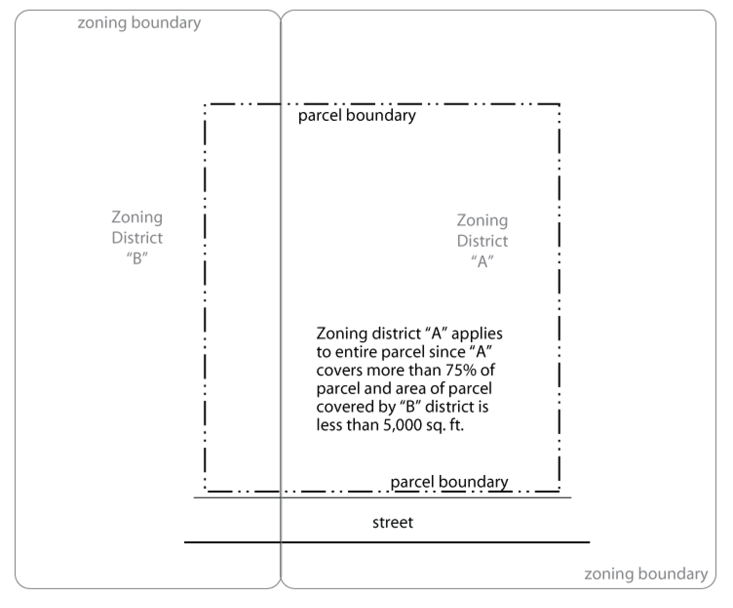
Figure 20.01-1 Split Zone Parcels
b.
Buildingsetbacks do not apply along base zoning district boundary lines that split a parcel under single ownership.
c.
If any use, building or structure rendered nonconforming by the split-zonedparcel provisions of this section is accidentally damaged or destroyed it may be reestablished, as long as the reestablishment does not increase the extent of nonconformity.
(Ord. 3735, 2024; Ord. 3439, 2010; Ord. 3410, 2009)
20.01.110 - Transitional Provisions
The provisions of this section address the transition from the previous zoning ordinance (the one in effect before the effective date specified in 20.01.020) and this zoning ordinance.
A.
Applications Submitted Before November 4, 2009
Development applications that were submitted in complete form and are pending approval on the effective date
specified in 20.01.020 must be reviewed wholly under the terms of the zoning ordinance in effect immediately
before the effective date specified in 20.01.020.
B.
Site-Specific Development Plans Approved Before November 4, 2009
1.
Permits may be issued for previously approved, unexpired site-specific development plans in accordance with the approved plan. Site-specific development plans approved before November 4, 2009 will remain valid until November 4, 2011 unless a phasing plan or different lapse of approval date is approved.
2.
The zoning officer is authorized to grant up to a one time extension for no more than one additional year if the zoning officer determines that the extension is necessary to address delays beyond the reasonable control of the applicant. After the lapse of approval date, no permits or other approvals may be issued except in accordance with the standards and procedures of this zoning ordinance.
3.
For purposes of this section, "site-specific development plans" are plans or plats submitted by a landowner or a landowner's authorized representative describing with reasonable certainty the type and intensity of development to be carried out on a specific parcel and that have been approved by Development Services, Design Review Board, or City Council. Such plans may be in the form of planned unit developments, planned neighborhood clusters, conditional uses, or other similar development plans, as determined by the zoning officer.
C.
Permits Issued Before November 4, 2009
Any building, development or structure for which a permit number was accepted for processing before November 4, 2009 may
be completed in conformance with the issued building permit and other applicable permits
and conditions, even if such building, development or structure does not fully comply with provisions of this zoning ordinance. If building is not commenced and completed within the time allowed under the original permit
or any extension granted, then the building, development or structure may be constructed, completed and occupied only if it complies with the standards
of this zoning ordinance.
D.
Violations Continue
1.
Any violation of the previous zoning ordinance will continue to be a violation under this zoning ordinance and be subject to penalties and enforcement under Chapter 20.01.
2.
If the use, development, construction or other activity that was a violation under the previous ordinance complies with the express terms of this zoning ordinance, enforcement action will cease, except to the extent of collecting penalties for violations that occurred before the effective date specified in 20.01.020.
3.
The adoption of this zoning ordinance does not affect nor prevent any pending or future prosecution of, or action to abate, violations of the previous ordinance that occurred before the effective date specified in 20.01.020.
E.
Nonconformities
1.
Any nonconformity under the previous zoning ordinance will also be a nonconformity under this zoning ordinance, as long as the situation that resulted in the nonconforming status under the previous regulation continues to exist.
2.
If, however, a nonconforming situation under previous zoning regulations becomes conforming because of the adoption of this zoning ordinance, or any subsequent amendment to it, then the situation will no longer be considered a nonconformity.
3.
A situation that did not constitute a (lawful) nonconforming situation under the previously adopted zoning ordinance does not achieve (lawful) nonconforming status under this zoning ordinance merely by repeal of the previous zoning ordinance.
F.
Existing Uses
1.
When a use classified as a conditional use under this zoning ordinance exists as a conditional use or permitted use on the effective dates specified in 20.01.020, such use will be considered a lawfully establishedconditional use.
2.
When any amendment to this zoning ordinance changes the classification of a permitted use to a conditional use, any use lawfully established before such amendment will be considered a lawfully establishedconditional use after the effective date of such amendment.
Commentary: Paragraphs F.1 and F.2. are intended to clarify that lawful, existing uses are not rendered nonconforming (or illegal) merely because they were not approved through the conditional use process.
3.
A lawfully established existing use that is not allowed as a conditional use or permitted use in the district in which the use is now located will be considered a nonconforming use and will be subject to all applicable regulations of Chapter 20.80.
G.
Zoning District Name Conversions
The zoning district names and map symbols in effect before November 4, 2009, will
be converted as follows:
H.
Design Review
1.
PUDs, SDs, Board Approvals, and Staff Agreements (established prior to this ordinance) that reference the Design Review Board shall now hereafter transition authority and power in full to the Zoning Officer.
Table 20.01-1 Zoning District Name Conversions
(Ord. 3769, 2025; Ord. 3733, 2024; Ord. 3723, 2023; Ord. 3439, 2010; Ord. 3410, 2009)
Note— 20.01.110.H—Interim provision, expires March 24, 2026.
20.01.120 - Special Districts/Overlay Districts established under Title 19
Special zoning districts or Overlay Districts approved before November 4, 2009 will continue to be governed by the adopted special zoning district or overlay district regulations according to the last archived version of Title 19 unless the regulations of Title 20 explicitly state otherwise or the districts have been incorporated as a Neighborhood character Overlay district per Title 20, and unless and until such time as the subject property is rezoned to another zoning classification in accordance with the zoning amendment procedures of 20.85.040. When development standards in a Special district or an "Overlay District Established under Title 19" refer to Title 19, the "Missoula Zoning Ordinance" (or similar phrase), or are silent regarding additional standards, the standards of the last archived version of Title 19 will apply.
Commentary: Regulations and standards that apply in special zoning districts can be found in Development Services.
(Ord. 3439, 2010; Ord. 3410, 2009)
20.01.130 - Severability
If any portion of this zoning ordinance is held to be invalid or unconstitutional by a court of competent jurisdiction, that portion is to be deemed severed from the zoning ordinance and in no way affects the validity of the remainder of the zoning ordinance.
(Ord. 3439, 2010; Ord. 3410, 2009)