
Missoula City Zoning Code
CHAPTER 20
25 - Overlay Districts
20.25.010 - General
A.
Establishment
1.
Overlay district regulations may be established or amended only in accordance with the amendment procedures of 20.85.040.
2.
Overlay zoning district boundaries may be established, amended or removed only in accordance with the zoning amendment procedures of 20.85.040.
B.
Interpretation
Overlay zoning district regulations apply in combination with underlying (base) zoning
district regulations and all other applicable regulations of this zoning ordinance.
When overlay district standards conflict with standards that would otherwise apply
under this zoning ordinance, the regulations of the overlay zoning district govern. Otherwise, all applicable regulations of this zoning ordinance apply in overlay districts.
(Ord. 3439, 2010; Ord. 3410, 2009)
20.25.020 - /P, Pedestrian Overlay
A.
Purpose
The /P, Pedestrian Overlay district is primarily intended to preserve and enhance the character of pedestrian-oriented
streets and, in turn, to promote street-level activity, economic vitality and pedestrian
safety and comfort.
B.
Applicability
The standards of this section apply to all development in /P overlay districts unless otherwise expressly stated. Single-purpose residential buildings must comply with the driveway and vehicle access provisions of 20.25.020.H; they
are exempt from all other /P overlay district regulations.
C.
BuildingPlacement
1.
Buildings must abut the sidewalk or be located within five feet of the sidewalk for at least 60% of the property line along the primary street frontage and for at least 40% of the property line along the secondary (side) street frontage. For the purpose of this provision, the "primary street frontage" is the frontage abutting the street that has the longest length of street frontage classified in the /P overlay district. "Secondary street frontages" exist along those streets that intersect the primary street.
2.
On a corner parcel, the building must "hold the corner." In other words, the minimum building frontage requirements of 20.25.020.C.1 must be measured from the intersection of the street side and front property lines except in cases when intersection visibility requirements impose greater building setback requirements.
Figure 20.25-1 /P, Pedestrian Overlay, Building Placement, Corner Parcels
3.
These building placement standards do not apply to outdoor seating or dining areas, permitted arcades, public plazas, parks or recessed entries that accommodate useable pedestrian gathering spaces abutting primary and secondary frontages.
4.
The zoning officer is authorized to approve an administrative adjustment to the building placement standards of this subsection in accordance with the procedures of 20.85.110.
D.
Ground-Floor Glazed Area
1.
Windows or other glazed area must cover at least 60% of the public street-facing ground floor building wall. Darkly tinted, mirrored or highly reflective glazing may not be counted toward minimum glazed area requirements. On corner parcels, this 60% glazed area requirement applies only along the primary street. In the event that these minimum glazed area requirements conflict with city building (energy) code requirements, the building (energy) code governs.
2.
Glazed area requirements shall apply to that area of the ground floor building wall facing a public street up to the finished ceiling height of the first floor building space.
Figure 20.25-2 /P, Pedestrian Overlay, Ground-floor Glazed Area
3.
Display windows that do not provide views into the interior of the building may be counted towards satisfying up to 50% of the minimum glazed area requirements, provided that they are internally illuminated and are at least two feet in depth.
4.
The bottom of any window or product display window used to satisfy these glazed area requirements may not be more than 30 inches above the finished grade of the first floor building space.
5.
The zoning officer is authorized to approve an administrative adjustment to the ground-floor glazed area standards of this subsection in accordance with 20.85.110.
E.
Doors and Entrances
1.
Buildings must have a working public entrance facing the primary street. Entrances at building corners may be used to satisfy this requirement.
2.
Building entrances may include doors to individual shops or businesses, lobby entrances, entrances to pedestrian-oriented plazas or courtyard entrances to a cluster of shops or businesses.
3.
The zoning officer is authorized to approve an administrative adjustment to the door and entrance standards of this subsection in accordance with 20.85.110.
Figure 20.25-3 /P, Pedestrian Overlay, Doors and Entrances
F.
Ground-Floor Commercial Floor Space
1.
The minimum floor-to-ceiling height of all ground floor space, other than allowed parking areas, must be at least 13 feet.
2.
Ground floor space must contain the following minimum floor area:
a.
At least 800 square feet or 25% of the parcel area (whichever is greater) on parcels with street frontage of less than 50 feet (as measured along the shorter street frontage on parcels containing multiple street frontages); or
b.
At least 20% of the parcel area on parcels with 50 feet of street frontage or more (as measured along the shorter street frontage on parcels containing multiple street frontages).
3.
Only the following uses are allowed on the ground floor of buildings within 50 feet of primary street property (ROW) line:
a.
Artist Work or Sales Space;
b.
Eating and Drinking Establishments;
c.
Food and Beverage Retail Sales;
d.
Retail Sales; or
e.
Personal Improvement Service.
Commentary: This provision is intended to promote pedestrian-oriented uses along the ground floorstreet frontage, but does allow other uses to be located on the ground floor if they are located 50 feet or more from the primary street property line.
G.
Parking
1.
Any off-street parking that is provided must be located behind the building or within or under the building.
2.
When the depth of the parcel is insufficient to permit required parking to the rear of the building, parking may be located to the side of the building, provided that it does not occupy more than 40% of the street frontage and it is separated from the sidewalk by perimeter parking lot landscaping in accordance with 20.65.050. If the parking lot perimeter landscaping requirements of 20.65.050 do not apply, the parking must be separated from the sidewalk by a solid wall between 36 and 42 inches in height.
Figure 20.25-4 /P, Pedestrian Overlay, Parking
H.
Driveways and Vehicle Access
No curb cuts may be made unless no other means of access is available, in which case
the zoning officer is authorized to permit up to one curb cut, subject to approval
by the city engineer. The city engineer is authorized to approve an administrative adjustment to the driveway and vehicle access standards of this subsection in accordance with
20.85.110.
(Ord. 3439, 2010; Ord. 3410, 2009)
20.25.030 - /PUD, Planned Unit Development Overlay
A.
Purpose
1.
General
The /PUD, Planned Unit Development Overlay district is intended to accommodate development that may be difficult if not impossible to carry out under otherwise applicable zoning
district standards. Examples of the types of development that may benefit from the PUD overlay district include the following:
a.
Enhanced Protection of Natural Resource Areas
Developments that offer enhanced protection of natural resources and sensitive environmental
features, including streams, water bodies, floodplains, wetlands, steep slopes, woodlands, wildlife habitats and native plant communities.
b.
Traditional Urban Development
Developments characterized by parcel configurations, street patterns, streetscapes,
and neighborhood amenities commonly found in urban neighborhoods platted or otherwise
created before the 1950s.
c.
Mixed-use Development
Developments that contain a complementary mix of residential and non-residential uses.
d.
Affordable Housing
Development that meets the definition of Affordable Housing found in Chapter 20.100.
2.
Objectives
Different types of PUDs will promote different planning goals. In general, however,
PUDs are intended to promote the following objectives:
a.
Implementation of and consistency with the city's adopted plans and policies;
b.
Flexibility and creativity in responding to changing social, economic and market conditions allowing greater public benefits than could be achieved using conventional zoning and development regulations;
c.
Efficient and economical provision of public facilities and services;
d.
Communities that provide economic opportunity and environmental and social equity for residents;
e.
Variety in housing types and sizes to accommodate households of all ages, sizes, incomes and lifestyle choices;
f.
Compact, mixed-use development patterns where residential, commercial, civic, and open spaces are located in close proximity to one another;
g.
A coordinated transportation system that includes an inter-connected hierarchy of facilities for pedestrians, bicycles, and vehicles;
h.
Compatibility of buildings and other improvements as determined by their arrangement, massing, form, character and landscaping;
i.
The incorporation of open space amenities and natural resource features into the development design;
j.
Low-impact development (LID) practices; and
k.
Attractive, high-quality landscaping, lighting, architecture and signage that reflect the unique character of the development.
B.
Unified Control
No application for PUD zoning approval will be accepted or approved unless all of
the property included in the application is under unified ownership or a single entity's
control.
C.
Procedure
PUDs must be reviewed and approved in accordance with the procedures of 20.85.060.
D.
Zoning Map
Approved PUDs must be identified on the zoning map by appending the map symbol "/PUD"
as a suffix to the base zoning district classification, as in "R80/PUD."
E.
Developer's Statement of Intent
Each PUD application must include a written explanation from the applicant describing
the community benefits of the proposed development and how the proposed development provides greater benefits to the city than would a development carried out in accordance with otherwise applicable zoning ordinance standards. The
statement must also include a comparison of the proposed development with the standards of the base zoning district and the submittal information necessary for a Preliminary Development Plan (see 20.85.060.C.1).
F.
Approval Criteria
A /PUD overlay zoning district may be approved only when the City Council determines that the proposed PUD would
result in a greater benefit to the city as a whole than would development under conventional zoning district regulations. Such greater benefit may include
implementation of adopted planning policies, natural resource preservation, urban
design, neighborhood/community amenities or an overall level of development quality.
G.
Standards Eligible for Modification
Unless otherwise expressly approved by the City Council as part of the PUD approval
process, PUDs are subject to all applicable standards of this zoning ordinance. The
City Council is authorized to approve PUDs that deviate from strict compliance with
specified standards if they determine that the resulting development satisfies the approval criteria of 20.25.030.F.
1.
Allowed Uses
A list of uses to be allowed in a PUD must be approved as part of the PUD approval
process. Regardless of the underlying zoning, the City Council may approve a mix of
use types within a PUD as a means of accommodating mixed-use developments and developments
with a broader range of housing types and affordable housing options than allowed
by the underlying zoning district.
2.
ParcelSize
Minimum parcel area and width standards of the base zoning district may be reduced as part of the PUD approval, provided that parcel sizes are adequate
to safely accommodate all proposed buildings and site features.
3.
Residential Density
The maximum allowable residential density of the base zoning district may be increased if the City Council determines that such an increase is warranted
to support the public benefit likely to result from the proposed development and such density increase can be supported by existing and planned public facilities and services.
4.
Setbacks
The minimum setback standards of the base zoning district may be reduced as part of the PUD approval.
5.
Height
The City Council may allow an increase in allowable building heights if it determines
that such an increase is warranted to support the public benefit likely to result
from the proposed development.
6.
Parking and Loading
Off-street parking and loading requirements may be modified when the City Council
determines that modified requirements are in keeping with projected parking and loading
demand of the proposed development, that other means of meeting access demand will be provided or that the requested
modifications will better meet the purpose of the PUD overlay. The city engineer must
review and make a recommendation on requests for modification of parking and loading
requirements.
7.
Streets
Alternatives to otherwise "standard" street cross-sections and designs may be approved
when the City Council determines that such alternative designs would better meet the
purpose of the PUD overlay, while still providing a safe and efficient traffic circulation
system. The city engineer and fire chief must review and make recommendations on requests
for alternative street standards.
(Ord. 3669, 2020; Ord. 3439, 2010; Ord. 3410, 2009)
20.25.035 - /AR, Adaptive Reuse Overlay
A.
Purpose
1.
General
a.
This section establishes the general authority and procedures for establishing the /AR Adaptive Reuse Overlay DistrictOverlay District regulation, herein referred to as /AR District.
b.
The /AR District is intended to facilitate the adaptation and continuing use of Historically Significant Buildings in the community. Under the guidance of these regulations and historic preservation review, additional building and land uses may be allowed on properties that would not ordinarily permit them.
2.
Objectives
a.
Promote adaptive reuse of historic buildings as part of Missoula's broader goals in supporting historic preservation, environmental sustainability, and economic and community development.
b.
Recognize the social, economic, and environmental value of Historically Significant Buildings.
c.
Encourage historic preservation beyond established historic districts.
d.
Allow the conversion of existing building uses into new building uses that maintain or enhance the character of the community and further extend the life of a buildingbuilding or space.
e.
Reduce the environmental hazards and costs associated with new constructionconstruction.
f.
Enhance economic growth.
B.
Definitions
Adaptive Reuse - The process of reusing an existing buildingbuilding, or portion of a buildingbuilding, for a purpose other than which it was originally built or designed for, currently used for, or if no change of use is occurring, for the benefit of a substantial rehabilitation.
Historically Significant Building - Any buildingbuilding eligible for inclusion on the National Register of Historic Places as defined in 36 CFR 60.4, any buildingbuilding that is included in Missoula's Inventory of Historic Resources ("Local Inventory" 20.30.030), or any contributing buildingbuilding in a National Register Historic District (20.30.030).
C.
Selection Criteria
1.
The /AR District may only be applied to a parcelparcel that contains an existing buildingbuilding which meets the definition of Historically Significant Building, and must be for an adaptive reuse purpose (Section 20.25.035.B).
2.
The Historic Preservation Commission and the historic preservation officer will determine whether a project qualifies for the /AR District. Determination of eligibility for the /AR District shall be made using Section 20.30.040 (Designation Criteria for an Historic Resource).
3.
The associated project must be in conformance with 20.25.035.A.2.
D.
Establishment of District
1.
/AR Districts are established in accordance with the zoning amendment procedures of 20.85.040, in addition to Review Criteria found in this section.
2.
An application to establish an /AR District may be initiated only by the property owner or the property owner's designee.
E.
Review Criteria
1.
Requirements will vary from one context to another and will be assessed on a district-by-district basis. Each /AR District is unique and shall be reviewed as it relates to public health, safety and general welfare as well as its contribution to the preservation of historic buildings.
2.
Impacts to the surrounding area will be evaluated and shall include, but not be limited to, light, traffic, parking, landscapelandscape and buffering, operating hours, neighborhood character and generally as to whether the proposed overlay districtoverlay district is contextually appropriate.
3.
Applicants must demonstrate a commitment to the preservation, maintenance and general welfare of the historic building.
F.
Review Authority and Procedure
1.
In establishing an /AR District, the City Council is authorized to adopt district-specific development and design standards to guide redevelopment within the subject /AR District.
2.
When redevelopment standards have been approved, each application for additional modification or alteration of an existing buildingbuilding within the designated /AR District must comply with those standards.
a.
If a proposed modification is beyond the parameters of the approved redevelopment standards, the applicant must get further approval from the City Council.
3.
The recommendation to establish an /AR District must be accompanied by a report containing at a minimum, the following information:
a.
A description of proposed use;
b.
A site plan showing the recommended boundaries of the /AR District, to include exhibits of existing conditions and proposed conditions;
c.
An explanation of how the area meets the selection criteria of 20.25.035.C;
d.
Any recommended district-specific development and design standards applicable to redevelopment within the district;
e.
An explanation of the planning and zoning implications related to the /AR designation of the proposed parcelparcel and application of the district-specific development and design standards; and
f.
Documentation that the HPC and/or HPO have deemed the property a Historically Significant Building qualifying for an /AR District.
G.
Applicability
The standards of this section applies to all /AR Districts.
1.
Proposed /AR Districts:
a.
Will not be required to amend the existing underlying land use designation or existing base zoning districtbase zoning district.
b.
Shall be contingent upon the designation of the buildingbuilding as being Historically Significant.
2.
Once an /AR District is created:
a.
BuildingsBuildings within an /AR District shall be subject to the Historic Preservation Permit process outlined in Section 20.85.085, and will be added to Missoula's Inventory of Historic Resources ("Local Inventory").
b.
Once an /AR District is approved, the associated adaptive reuse project must be initiated within three years of approval.
c.
If after approval, future proposals involve removal of or significant alteration to the historic resource, or the property loses its status as a Historically Significant Building, all provisions of approval are void, and regulations applicable to the property revert to those governing the underlying zoning district.
d.
Any alteration or expansion to a project within an /AR District shall be subject to Section 20.85.085.
3.
All or any portion of a Historically Significant Building may be converted for the purpose of the /AR District.
H.
Standards
Projects in an /AR District are subject to all applicable standards of this zoning
ordinance, unless otherwise stated.
1.
The City Council may grant, modify or deny some or all of the standards set forth below as part of the /AR District:
a.
Uses
A list of uses to be allowed in a /AR District must be approved as part of the /AR
District approval process. Regardless of the underlying zoning, the City Council may
approve a mix of use types within an /AR District as a means of accommodating the
reuse of any qualified buildingbuilding. However, new uses that emit noxious odors or excessive noise shall not be permitted,
unless the applicant demonstrates the use will not negatively affect nearby residences.
b.
DensityDensity
The /AR District may exceed the maximum densitydensity established by the underlying zoning district for the parcelparcel, so long as the added densitydensity is allowable by building code.
c.
Expedited Review
Projects within an /AR District shall receive expedited review throughout the City's
plan review process.
d.
Monetary Fees
Administrative fees associated with the adoption of an /AR District will be reduced
by half.
e.
Fire Code
Projects within an /AR District shall comply with the provisions set forth under Historic
Buildings in the adopted Fire Code and those provisions of NFPA 914, Code for Fire
Protection of Historic StructuresStructures.
(1)
Whenever there are practical difficulties involved in carrying out the provisions of the adopted Fire Code, the fire code official shall have the authority to grant modifications for individual cases. The fire code official shall find that individual circumstances exist that make following the strict letter of the Fire Code impractical, the proposed modification complies with the intent and purpose of the Fire Code, and that such modification does not lessen health, life and fire safety requirements.
2.
Additional standards
a.
Building Code
Projects within an /AR District may qualify for alternative building code compliance
subject to Section 3409 of the International Building Code. Proposed projects must
be able to demonstrate an alternative means or method of protecting public health,
safety, and welfare.
I.
Zoning Map
Approved /AR Districts must be identified on the zoning map by appending the map symbol
"/AR- X" as a suffix to the base zoning districtbase zoning district classification, and will be listed on the following table.
Districts Established
(Ord. 3643, 2019)
20.25.040 - /NC, Neighborhood Character Overlays Generally
A.
Purpose
This section established the general authority and procedure for establishment of
/NC, Neighborhood Character Overlay district regulations. /NC districts are intended
to:
1.
Recognize and protect the physical character of neighborhoods that exhibit unique development and building patterns;
2.
Encourage neighborhood investment in the form of construction and development that conform to the size, orientation and setting of existing buildings in the neighborhood;
3.
Implement adopted neighborhood plans;
4.
Foster development and redevelopment that are compatible with the scale and physical character of original buildings in the neighborhood through the use of development/design standards;
5.
Ensure a stabilized tax base; and
6.
Promote natural and cultural assets.
B.
Selection Criteria
An /NC district must be a geographically defined area that has a significant concentration,
linkage or continuity of sites that are united by physical development or architecture. To be eligible for /NC zoning, the area must comply with all of
the following criteria:
1.
The area must possess urban design, architectural or other physical development characteristics that create an identifiable setting, character and association; and
2.
The designated area must be a contiguous area of at least five acres. Areas of less than five acres may be designated if they abut and extend an existing /NC overlay district, or if deemed necessary by the City Council to address specific circumstances.
C.
Uses
Uses allowed by the underlying zoning district are allowed in all /NC Overlay districts unless expressly modified when the specific neighborhood character overlay district is adopted.
D.
Development/Design Standards
In establishing an /NC district, the City Council is authorized to adopt district-specific
development and design standards to guide development and redevelopment within the subject /NC district. When development and design standards
have been approved, each application for new construction or structural alteration of an existing building within the designated /NC must comply with those standards.
E.
Establishment of District
/NC zoning districts are established in accordance with the zoning amendment procedures
of 20.85.040, except that an application to establish an /NC district may be initiated only by
the City Council or by a petition signed either by the owners of 35% of the area within
the proposed /NC district or by at least 35% of the property owners within the proposed
district.
F.
Procedure
1.
/NC district regulations must be established in accordance with the zoning ordinance amendment procedures of 20.85.040.
a.
Once created, an /NC district may be applied to property in accordance with the zoning amendment procedures of 20.85.040. The Planning Board's recommendation to apply an /NC district must be accompanied by a report containing the following information:
(1)
A map showing the recommended boundaries of the /NC district;
(2)
An explanation of how the area meets the selection criteria of 20.25.040.B;
(3)
In the case of an area found to meet the criteria in 20.25.040.B, a description of the general pattern of development, including streets, parcels and buildings in the area;
(4)
Any recommended district-specific development and design standards applicable to development and redevelopment within the district; and
(5)
An explanation of the planning and zoning implications related to the designation of the proposed area and application of the district-specific development and design standards.
G.
Districts Established
The city's /NC overlay districts are listed below:
Commentary: A neighborhood conservation overlay district has been prepared for the Rattlesnake Valley area, but it has not been adopted (as a zoning district) or applied to property in the city. See Appendix B.
(Ord. 3704; Ord. 3620, 2018; Ord. 3612, 2018; Ord. 3609, 2018; Ord. 3439, 2010; Ord. 3410, 2009)
20.25.050 - /NC-B, Boulevard Neighborhood Character Overlay
A.
Purpose
The /NC-B, Boulevard Neighborhood Character Overlay district is primarily intended to preserve and enhance the appearance and civic value of boulevards
that:
1.
Are bordered by mature trees regularly placed;
2.
Contain a landscaped plaisance or mall along the sides or down the center; or
3.
Are otherwise arranged or landscaped so as to be of particular scenic, aesthetic, or recreational value.
B.
Applicability
The standards of this section apply to all development in /NC-B overlay districts unless otherwise expressly stated. Boulevard Neighborhood Character overlay districts must be designated through the zoning amendment procedure of 20.85.040. Such districts may consist of:
1.
Boulevards or portions of boulevards;
2.
All parcels immediately abutting the designated boulevard or boulevard segment; and
3.
Other parcels within 150 feet of the designated boulevard or boulevard segment.
Commentary: There is currently only one Boulevard Overlay district in Missoula, along a portion of Brooks Street.
C.
Location
A map of the /NC-B Overlay follows:
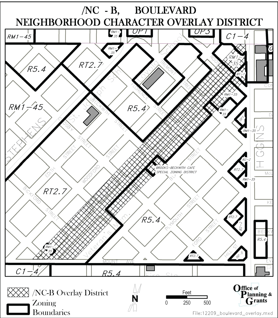
Map 20.25-1 /NC-B Overlay
Note: A full-size map is available for viewing in Development Services.
D.
Alterations and Improvements within the Right-of-Way
The city may not make or permit to be made any alterations in the public right-of-way
in any boulevard overlay district that would degrade the aesthetic values of the boulevard.
E.
Alterations and Improvement of Private Property
The regulations of this subsection apply to all new development and expansions of existing development that result in an increase in floor area by more than ten percent.
1.
No off-street parking may be constructed that would be visible from the boulevard.
2.
No curb cuts may be made along the boulevard unless no other means of access is available, in which case the zoning officer is authorized to permit up to one curb cut, subject to approval by the city engineer.
3.
No boulevard trees may be removed or harmed and no boulevard landscaping may be damaged, destroyed or otherwise impaired.
(Ord. 3439, 2010; Ord. 3410, 2009)
20.25.058 - /NC-RT, Riverfront Trails Neighborhood Character Overlay
A.
Purpose
The /NC-RT, Riverfront TrailsTrails Neighborhood Character Overlay DistrictOverlay District, is intended to create a variety of housing types, including large and small lotlot single-dwelling, townhousetownhouse, multi-dwelling, and senior living. The /NC-RT overlay districtoverlay district is intended to fit with the already established residential neighborhoods that adjoin
the /NC-RT overlay districtoverlay district, while allowing enhanced opportunities for conservation of open lands and buildingbuilding upon the adjacent civic land use already established. The /NC-RT, Riverfront TrailsTrails Neighborhood Character Overlay DistrictOverlay District enhances the base RT5.4 zoning by:
1.
Adapting setbacksetback and height standards of residential parcelsparcels to allow traditional neighborhood developmentdevelopment patterns and architectural diversity, including alleysalleys, rear garagesgarages, street facing townhousestownhouses, and courtyardcourtyard cluster housing types.
2.
Expanding the permitted uses to include a mix of residential and public/civic land uses which will add architectural and socioeconomic diversity to the neighborhood.
3.
Expanding the buildingbuilding types to provide a wide array of housing options, accommodating a range of householdhousehold sizes and generational characteristics.
4.
Incorporating trailstrails to provide for a variety of outdoor and recreational activities and clustering of residential uses to allow for conservation of open resource lands outside the /NC-RT overlay districtoverlay district.
B.
Applicability
1.
The /NC-RT overlay districtoverlay district regulations apply to the property legally described in the ordinance and in the location shown on Map 20.25.058-1.
2.
New constructionconstruction and re-development including additions, of primary structuresstructures shall address all parcel and building standards contained within the /NC-RT overlay districtoverlay district when developmentdevelopment is proposed.
Map 20.25.058-1
C.
General Standards
1.
Except as provided in this chapter, all applicable portions of the City of Missoula Zoning Ordinance Title 20 shall apply.
2.
Where four or more adjoining LotsLots access a Private Access and Utility EasementEasement, the townhousetownhouse development standards of Section 20.40.140 applicable to the street-facing facade of each buildingbuilding shall be applied to that facade which faces the Private Access and Utility EasementEasement. SetbackSetback standards shall be applied only to the outside boundary of each group of four LotsLots accessing the Private Access and Utility EasementEasement as if the four LotsLots were a single LotLot.
3.
GaragesGarages and carports that abut a Private Access and Utility EasementEasement must be set back at least 20 feet from the boundary of the Public Access and Utility EasementEasement.
D.
/NC-RT Overlay Sub-District Designations
The /NC-RT overlay sub-districts are designated as depicted on Map 20.25.058-1. Applicable
standards for each sub-district are defined in the following sections.
E.
Allowed Uses
Table 20.25.058-1. Allowed Uses per Sub-District
Additional uses identified with a "P" in the table above are permitted by-right within the overlay sub districts. Uses identified with a "C" in the table above are permitted conditionally.
F.
Residential BuildingResidential Building Types
Table 20.25.058-2. Allowed Residential BuildingResidential Building Types per Sub-District
Building types identified with a "P" in the table above are permitted within the overlay sub-districts.
Building types identified with a in the table above are not permitted.
G.
ParcelParcel and Building Standards
All primary structuresstructures shall comply with the parcel and building standards of the RT5.4 district, except
as provided below.
Table 20.25.058-3. ParcelParcel and Building Standards
[1] The maximum building height is 35 feet at the top of parapetparapet or bottom of roof eave, and a pitched roof may extend to a maximum height of 45 feet.
[2] The maximum building height at the point of the required minimum setbacksetback line is 35 feet, and the height may be increased above 35 feet by up to one foot (vertical) for each six inches of additional buildingbuilding setbacksetback or upper floor step-back, to a maximum of 45 feet.
Table 20.25.058-4. SetbackSetback Standards
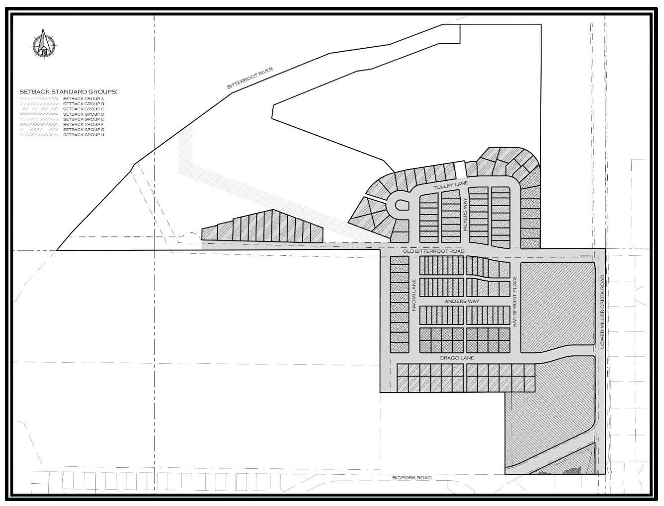
Map 20.25.058-2
(Ord. 3704, 2022)
20.25.060 - /NC-SR, Southside Riverfront Neighborhood Character Overlay
A.
Purpose
The /NC-SR, Southside Riverfront Neighborhood Character Overlay district is intended to accommodate the commercial and residential needs of the Southside
Riverfront commercial neighborhoods by permitting a mixture of residential and neighborhood-serving
commercial uses. This district allows existing uses to remain while encouraging a
mix of residential and commercial uses. The overlay district classifies existing parcels and existing uses as permitted. New development and new uses must address all design standards contained within the /NC-SR overlay district when development is proposed. The /NC-SR overlay district further defines allowed uses in the B2, C1, C2 and M1R districts, and establishes
additional design standards.
B.
Applicability
1.
The /NC-SR overlay district regulations apply only to areas within underlying base zoning of B2, C1, C2 or M1R.
2.
Rezoning to accommodate development of a neighborhood commercial use when not part of a neighborhood or community-wide planning process should be done through a /PUD rezoning rather than the /NC-SR district.
3.
The /NC-SR overlay district does not apply to areas within the designated 100-year floodplain.
C.
Location
A map of the /NC-SR Overlay follows:
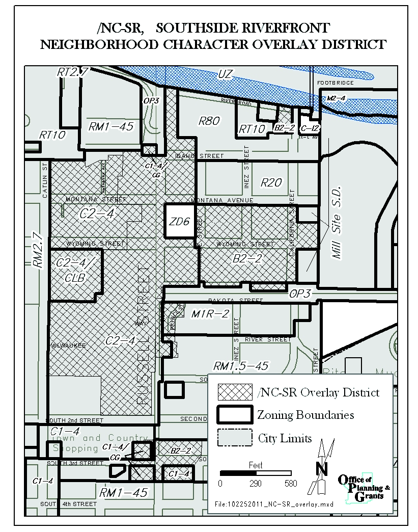
Map 20.25-2 /NC-SR Overlay
Note: A full-size map is available for viewing in Development Services.
D.
Parceland Building Standards
1.
Parcel Area
The minimum parcel area is 3,500 square feet, except that this minimum parcel area
requirement does not apply to parcels in lawful existence on July 13, 2011.
2.
Setbacks
a.
The minimum setback requirements of the underlying zoning district apply, except that a minimum rear setback of ten feet is required for C2-zoned parcels.
b.
Front setbacks may not exceed 40 feet in depth.
3.
Impervious Coverage
No parcel used for commercial or mixed-use purposes may be more than 85% covered with impervious surfaces.
4.
Height
Building heights for development on parcels adjacent to Russell Street may not exceed the maximum height limit of the underlying
zoning district or 65 feet, whichever is less. Buildings heights for construction in all other areas of the overlay may not exceed the maximum height limit of the
underlying zoning district or 45 feet, whichever is less.
E.
Allowed Uses
1.
The following uses are allowed in the /NC-SR overlay district:
a.
Uses allowed by the underlying zoning; and
b.
Uses in lawful existence on July 13, 2011;
c.
Commercial and industrial uses that are listed as prohibited uses per Subsection F below, but were in lawful existence on July 13, 2011 are considered permitted uses at their existing intensity, density and location, regardless of changes in ownership or tenancy. Such uses may be reestablished to their pre-existing density and intensity in the event of natural damage or destruction. They may be expanded on their existing parcel if all applicable base district and overlay district standards are met.
2.
Commercial and industrial uses in lawful existence on July 13, 2011 may be replaced by a use of similar or less intensity, as determined by the zoning officer. If a less intensive commercial or industrial use is established, the use may not later revert back to the previous intensity.
F.
Prohibited Uses
The following uses may not be established in the /NC-SR district:
1.
Drive-in and drive-through restaurants;
2.
Gasoline and fuel sales;
3.
General motor vehicle repair;
4.
Taxidermy shops;
5.
Pawnshops;
6.
Non-accessory parking;
7.
Light and heavy equipment sales/rentals;
8.
Residential storage warehouse;
9.
Casinos, except as an accessory use to a principal use for which the State Department of Revenue, pursuant to Montana law, has granted an on-premise beer and wine sales license that includes gambling or an on-premises liquor, beer, and wine sales license.
G.
Parking
1.
Location
a.
For multi-dwelling and nonresidential uses, off-street parking and vehicular use areas must be located behind the building or within or under the building.
b.
When the depth of the parcel is insufficient to permit required nonresidential or multi-dwelling parking to the rear of the building, parking may be located to the side of the building, provided that it does not occupy more than 50% of the street frontage and it is separated from the sidewalk by perimeter parking lot landscaping in accordance with 20.65.050. If the parking lot perimeter landscaping requirements of 20.65.050 do not apply, the parking must be separated from the sidewalk by a solid wall between 36 and 42 inches in height.
c.
On a corner parcel, parking may not be located within 50 feet of the intersection of the front and street side property lines.
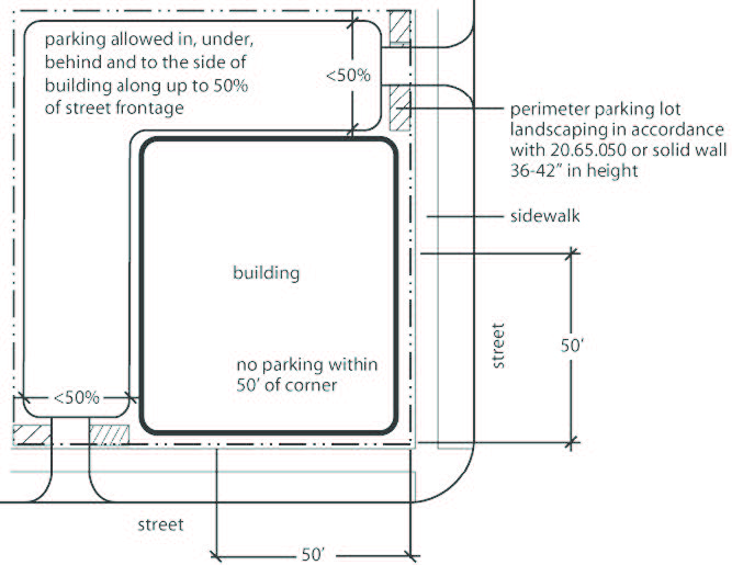
Figure 20.25-5 /NC-SR Overlay, Parking, Location, Corner Parcel
2.
Special Parking Requirements for B2-Zoned Parcels
a.
On B2-zoned parcels, off-street parking space requirements are reduced from the minimums established in Chapter 20.60 if the parcel has frontage on and direct access to a street improved to city specifications that provides on-street parking along the entire block face. In such cases, the minimum parking requirements are as follows:
(1)
Minimum parking spaces permitted for commercial uses: 50% of the minimum parking ratios established in Chapter 20.60.
(2)
Maximum parking spaces permitted for commercial uses: 75% of the minimum parking ratios established in Chapter 20.60.
b.
The parking reductions authorized in 20.25.060.G.2.a do not apply to situations in which programmed street improvements or modifications included in adopted planning documents would eliminate the requisite on-street parking, as determined by the zoning officer in consultation with the city engineer.
H.
Building Design
1.
Entryways
a.
Principal entryways to detached houses must be clearly visible from a public street or right-of-way, other than an alley.
b.
Non-residential uses must have a working public entrance located on the buildingfaçade that faces the primary street or right-of-way. Buildings on any corner lot may have an entrance that is angled towards the intersection if that entrance will be visible from both streets.
2.
Glazed Area
Commercial and vertical mixed-use buildings must include windows or other glazed area on at least 20% of all street-facing ground floor building walls, measured and placed between finished grade and 12 feet above grade. Darkly tinted, mirrored or highly reflective glazing may
not be counted toward minimum glazed area requirements.
3.
Exterior Walls
Exterior walls on commercial and residential buildings may not have a flat, monolithic uninterrupted façade of more than 30 linear feet. This standard may be met by providing at least one of
the following options:
a.
Offsetting planes of at least one foot;
b.
Bay windows;
c.
Indented or recessed windows and entries;
d.
Porches and balconies;
e.
Overhanging awnings and space frames; or
f.
Other architectural form that causes at least one foot of relief in the façade.
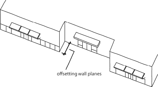
Figure 20.25-6 /NC-SR Overlay, Building Design, Exterior Walls
4.
Exceptions
The Zoning Officer is authorized to approve exceptions to the building design standards
of 20.25.060.H in accordance with the design review procedures of 20.85.080.
I.
Signs
B2-zoned properties are limited to one wall sign per business per street frontage, with a maximum sign area of 12 square feet. In the case of multiple businesses within one building using a common entrance, one wall sign per commercial structure per street frontage is allowed with a maximum sign area of 18 square feet. Only indirect illumination is allowed for signs in the B2 district.
J.
Hours of Operation
All uses in the B2 district are limited to hours of operation between 7:00 a.m. and
10:00 p.m., with the exception of residential uses, lodging uses and property approved
for use as a casino, tavern or nightclub.
(Ord. 3769, 2025; Ord. 3733, 2024; Ord. 3723, 2023; Ord. 3531, 2014; Ord. 3471, 2011; Ord. 3465, 2011; Ord. 3439, 2010; Ord. 3410, 2009)
Note— 20.25.060.H.4—Interim provision, expires March 24, 2026.
20.25.070 - /NC-HFM, Historic Fort Missoula Neighborhood Character Overlay
A.
Purpose
The /NC-HFM, Historic Fort Missoula Neighborhood Character Overlay district is intended to protect buildings and grounds in the Fort Missoula area from modifications that obscure or eradicate
significant features of their historic character; to promote restoration and continued
maintenance, and to protect the district from the effects of incompatible development.
B.
Location
A map of the /NC-HFM Overlay follows:
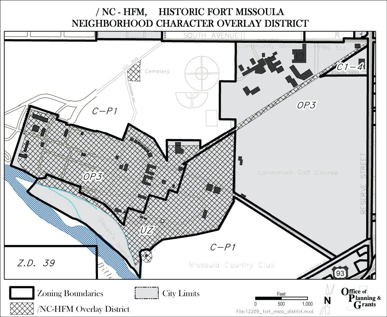
Map 20.25-3 /NC-HFM
Note: A full-size map is available for viewing in Development Services.
C.
Applicability
The regulatory area is that area on the National Register of Historic Sites, including
the cemetery.
D.
Permitted and Prohibited Uses
Uses allowed by the underlying zoning district are allowed in the regulatory area
of the /NC-HFM overlay district unless expressly prohibited in this section.
1.
Prohibited uses include the following:
a.
Sewage treatment plants;
b.
Public or private zoos;
c.
Crematories;
d.
Airports and landing fields; and
e.
Establishments that sell liquor, beer or wine, or provide gambling facilities.
2.
Permitted uses include the following:
a.
Planned Unit Developments;
b.
Medical offices; and
c.
Community residential facilities serving eight or fewer residents.
E.
Historic Preservation Commission
A Historic Preservation Commission is established to implement the purposes of the
Historic Fort Missoula Neighborhood Character Overlay district. The Historic Preservation Commission is authorized to perform those duties that
are described in 20.90.030.
F.
Historic Preservation Permits
1.
Procedure
In order to preserve the historical integrity of the fort environs, any development or structural alteration requiring a building permit within the /NC-HFM overlay district must be reviewed by the historic preservation officer for a historic preservation
permit. A historic preservation permit is required for any activity that requires
a zoning compliance permit. The historic preservation officer must forward a recommendation
to the Historic Preservation Commission. Appeals of decisions of the Historic Preservation
Commission may be made to the Board of Adjustment.
2.
Submittal Requirements
a.
Information must be provided to the zoning officer to review prior to granting or denying a historic preservation permit. All materials to be submitted must be prepared on 8½" × 11" paper and packaged or bound to fit a standard letter-size file. Applications that involve more voluminous architectural plans and specifications may be accompanied by simplified sketches, details and supporting documentation, on letter-size paper, that synthesize the detailed design documents.
The extent of documentation to be submitted on any project will be dictated by the scope of the planned alteration and the information reasonably necessary for the zoning officer to make a determination. At a minimum, the following items must be included in the submission:
(1)
Completed application form provided by Development Services.
(2)
One current picture of each elevation of each structure planned to be altered and such additional pictures of the specific elements of the structure or property to be altered that will clearly express the nature and extent of change planned. Except when otherwise recommended, no more than eight pictures should be submitted and all pictures must be mounted on letter-size sheets and clearly annotated with the property address, elevation direction and relevant information.
(3)
Site sketch (oriented with north at the top of the page and approximately to scale) showing site boundaries, street and alley frontages and names, and location of all structures and distances (to the nearest foot) between buildings and from buildings to property lines.
(4)
Historical information, including available data such as pictures, plans, authenticated verbal records and similar research documentation that may be relevant to the planned alteration.
(5)
Plans, sketches, pictures, specifications and other data that clearly express the applicant's proposed alterations.
(6)
A schedule of planned actions that will lead to the completed alterations.
(7)
Such other information as may be required by Development Services in order to ensure a complete and competent review of the proposal.
G.
Review Criteria
All structures must be built with the consideration that they are in a historic district. In addition
to the review criteria that apply for all historic resources (20.85.085 Historic Preservation
Permit procedures), proposals in the Historic Fort Missoula Neighborhood Character
Overlay district must be reviewed for compliance with the Development Guidelines and Standards for
the Fort Missoula Historic District, which are on file and available for public inspection
in Development Services.
H.
Designated Cultural Resources
Designated cultural resources in the Historic Fort Missoula Neighborhood Character
Overlay district, including contributing elements, are on file and available for public inspection
in Development Services.
I.
Related Plans and Guidelines
The Fort Missoula Plan and the application for the National Register of Historic Places
Inventory provide information about the nature of the site and buildings in the area. In addition, the area is discussed in the Missoula Urban Comprehensive
Plan and the Report to Missoula: $16,000.00 Pilot Project, Park/Open Space/Resource
Planning and Management.
(Ord. 3769, 2025; Ord. 3733, 2024; Ord. 3723, 2023; Ord. 3471, 2011; Ord. 3439, 2010; Ord. 3410, 2009)
Note— 20.25.070.E—Interim provision, expires March 24, 2026.
20.25.071 - /NC-RG, Rattlesnake Gardens Neighborhood Character Overlay
A.
Purpose
The Rattlesnake Gardens Neighborhood Character Overlay district is intended to accommodate a mixture of residential and neighborhood serving commercial
uses.
B.
Applicability
1.
The standards apply to the property legally described in the ordinance and in the location shown on Map 20.25-4/NC-RG.
2.
All Title 20 standards apply unless addressed specifically in the overlay.
C.
Location
See Map 20.25-4/NC-RG.
D.
Parcel and building standards
Title 20, RT10 standards apply including setbacks, height and density.
E.
Permitted and Conditional Uses
1.
All uses permitted and conditional in RT10.
2.
Additional permitted uses:
a.
Restaurant
b.
Food and Beverage Retail Sales
F.
Prohibited Uses
1.
All uses prohibited in RT10 (except for additional uses noted in E.2 above);
2.
Drive-through commercial uses; and
3.
Outdoor storage or display except for plant sales.
G.
Parking
1.
Vehicular: Per Title 20, Chapter 20.60 except as follows:
a.
Maximum Parking Requirement: for all residential and non-residential uses combined no more than 27 spaces, plus garages and driveway for duplex.
2.
Short term bike parking:
a.
16 spaces required for all residential and non-residential uses.
3.
Long term bike parking:
a.
Commercial Uses: 1 per every 5 employees, 1 space minimum.
H.
Site and Building Design Standards
1.
Site Development Plan:
Map 20.25-4/NC-RG diagrams the locations for different uses:
a.
Restaurant and Food and Beverage Retail Sales with one dwelling unit;
b.
Parking lot; and
c.
Duplex with garage and driveway for duplex.
2.
Landscaping:
Per Title 20 landscaping standards except as follows:
a.
Buffering is required between non-residential uses and abutting adjacent residential property (not across ROW).
b.
Alternative compliance for Landscape Architect design does not apply to buffers between commercial and adjacent residential property or required screening.
3.
Building design:
a.
No entrances to non-residential uses on Powell St. beyond existing service entrances.
b.
Blank facades are not permitted on facades fronting on a street.
c.
Facades fronting on a street shall have repetitive door and window openings.
4.
Accessory Buildings:
a.
Per Title 20, Section 20.45.020.
b.
Accessory structures count toward the lot coverage requirement except those exempt in Section 20.25.071.H.2.
5.
Exterior lighting:
Per Title 8, Chapter 8.64 Missoula Outdoor Lighting Ordinance and the following:
a.
Exterior lighting is only permitted for safety, security and external lighting of signs.
b.
Maximum twelve (12) foot height for light fixtures.
c.
No blinking, flashing or high intensity lighting.
I.
Signs
Per Title 20, Residential standards except as noted below:
1.
Ground sign: Maximum of one (1) ground sign not exceeding thirty-six (36) square feet and maximum of six (6) feet in height permitted for the property. Internal illumination is prohibited.
2.
Rattlesnake Drive and Parking Lot Frontage: One (1) wall sign per business, a maximum of six (6) square feet each. Internal illumination is prohibited.
3.
Powell Street Frontage: One (1) wall sign, a maximum of six (6) square feet. Internal illumination is prohibited.
4.
Window signs: Not allowed in windows facing residential property. Not allowed in windows within twenty (20) feet of adjacent residential property. Window signs may not exceed more than thirty percent (30%) of the window area and may not exceed a maximum of five (5) square feet in size.
J.
Hours of Operation
Non-residential uses may not be open to the public between the hours of 11 PM and
6 AM. Exterior windows and service doors in the non-residential use areas shall remain
closed between 11 PM and 6 AM.
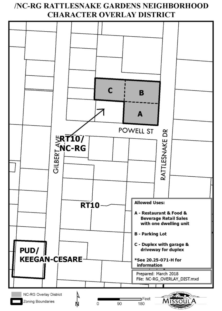
Map 20.25-4/NC-RG Overlay
(Ord. 3609, 2018)
20.25.072 - University District Neighborhood Character Overlay
A.
Purpose
The /NC-UD, University District Neighborhood Character Overlay district is intended to preserve and enhance the character of the University neighborhood
by fostering rehabilitation, development, and redevelopment that is compatible with the scale, orientation and setting of
original buildings in the neighborhood. The overlay district is also intended to prevent the loss of housing units in the district by prohibiting
parcel aggregation for the purpose of building one disproportionate dwelling unit after demolishing two or more existing dwelling units.
The character of the University District Neighborhood is anchored in a wide variety of historic homes and architecturally significant structures spanning decades of growth within its original park-like setting which is defined by wide boulevards, ample setbacks and tree lined streets.
B.
Applicability
1.
The /NC-UD overlay district regulations apply only to areas within underlying R (residential) districts.
2.
New and re-development including additions, of primary structures shall address all parcel and building standards contained within the /NC-U overlay district when development is proposed.
C.
Location. A map of the /NC-UD Overlay Follows
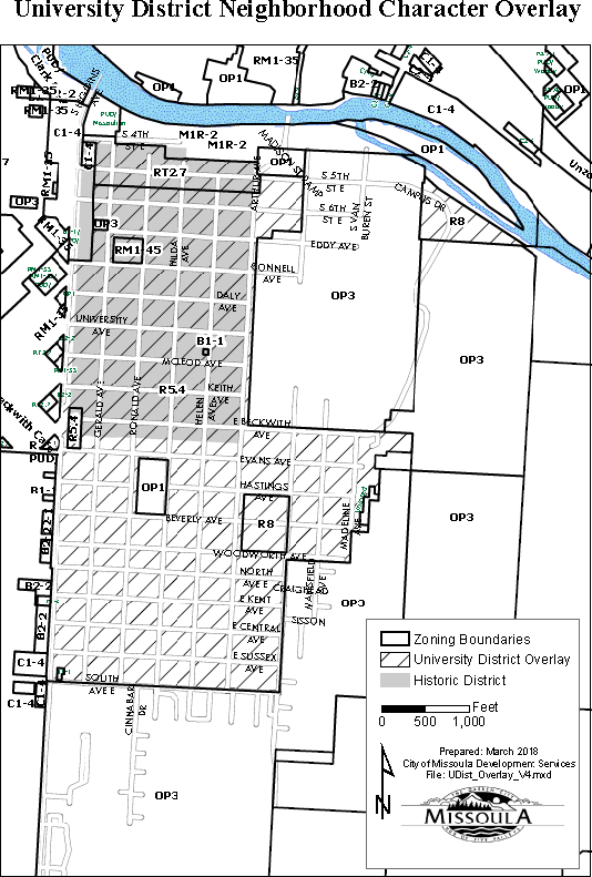
Map 20.25-5/NCUD
D.
Parcel and Building Standards
1.
Exceptions -
Note: Split corner parcels and corner alleyparcels are not subject to these requirements.
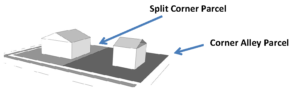
Figure 20.25-7
2.
Maximum Parcel Size -
Within the Neighborhood Character Overlay District, parcels may not be combined or expanded to create a parcel that exceeds 65 feet in width or exceed 8,450 square feet in area. Parcels under single ownership as of the adoption of this ordinance section may be divided
to create parcels greater than 65' x 130' (8,450 sq. ft.)
3.
Corner Parcel Street-side Facade Envelope - The height limit of the street side façade envelope is defined by an inwardly sloping 45-degree angle plane that begins at a horizontal line directly above the side 15' setback line. See Table 20.25-1 and Figure 20.25-7. All other parcel and building standards of Table 20.05-3 apply.
Table 20.25-1. Corner Parcel Building Façade Height Limits
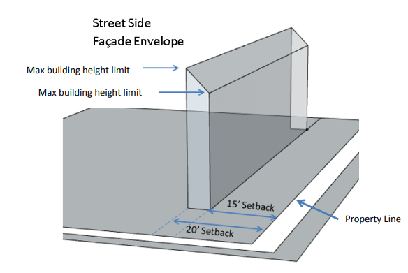
Figure 20.25-7
4.
Corner Parcel Street-Side Horizontal Façade Length Maximum - No uninterrupted (unmodulated) length of the street-side façade shall exceed 40 feet in length. The break in the façade shall be at least 12 feet in length and a minimum four feet in depth, extending the full height of the façade. See Figure 20.25-8.
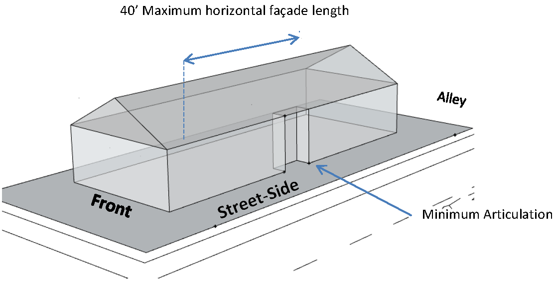
Figure 20.25-8
5.
Corner Parcel Large-lot Setbacks - New and re-development including additions on corner parcels over 80 feet in width are subject to the front and street-side setbacks of the existing primary structure. See Figure 20.25-9.
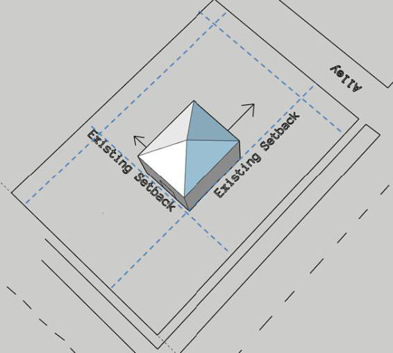
Figure 20.25-9
E.
Historic Character Consultation
For development within the University Historic District (see Map 20.25-5) the applicant and/or the
applicant's designer shall meet with the Historic Preservation Officer prior to submittal
of a building permit. In cases involving demolition, the consultation shall occur
prior to demolition permit approval. The meeting educates homeowners and developers
about the value of preserving the historic character of the University District Neighborhood
with architecture sensitive to the mass and proportions of existing structures.
(Ord. 3612, 6-18-2018)
20.25.075 - /NC-MDP, Missoula Development Park Overlay
A.
Purpose
The purpose of this overlay is to accommodate a mix of industrial and commercial land
uses and community service and support activities. These standards are meant to promote
a neighborhood of integrated uses and an enhanced image.
B.
Applicability
The standards of this section apply to all development in /NC-MDP Overlay district, including the Airway Boulevard Corridor sub-district within the /NC-MDP Overlay,
unless otherwise expressly stated. The overlay district classifies existing development as permitted. New development and additions to existing development must address all the regulations contained within the /NC-MDP overlay district.
C.
Location
A map of the /NC-MDP Overlay follows:
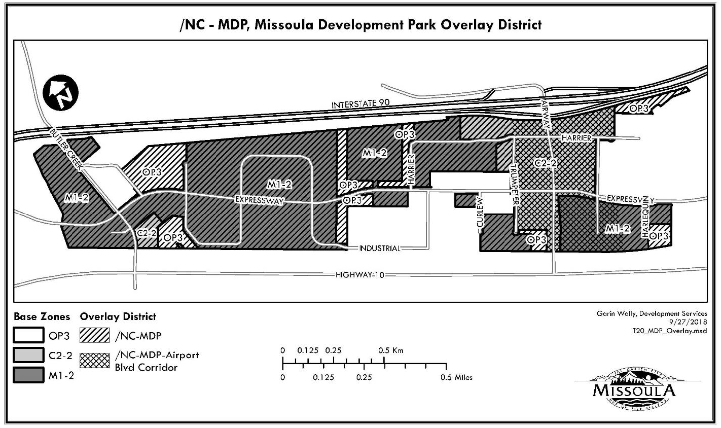
Map 20.25-1 /NC-MDP Overlay
D.
General Provisions
The Missoula Municipal Code shall apply to this Overlay. Wherever provisions of this
overlay conflict with the Missoula Municipal Code the provisions of the overlay shall
apply. The following chapters/sections in Title 20 do not apply in the /NC-MDP Overlay:
1.
Chapter 20.05 - Residential Districts.
2.
Chapter 20.55 - Cluster and Conservation Development.
3.
Chapter 20.70 - Miscellaneous Regulations.
4.
Section 20.40.050 - Enterprise Commercial Uses.
5.
Section 20.40.170 - Commercial Uses Not Exceeding 30,000 Square Feet.
E.
Definitions
1.
Accessory Apartments. One or more dwelling units within a business building or in a detached building co-located with a business on the same property, which provides complete, independent, and permanent living facilities for each household, are only for the use and tenancy of people associated with the main business(es), and which the total floor area of accessory apartments do not exceed 25% of the total floor area of the business uses on the parcel.
2.
Airway Boulevard Corridor. Airway Boulevard Corridor is a sub-district depicted on the zoning map generally described as two lots on either side of Airway Boulevard.
3.
Caretaker Apartment. One and only one dwelling unit within a business building which provides complete independent and permanent living facilities for one household. Occupancy of a caretaker apartment is restricted to the household of an owner or employee of the business in which it is located.
F.
Uses
1.
M1-2 Limited Industrial District. The following uses in Title 20, Table 20.15-1 are allowed, subject to the Title 20 approval procedure for permitted and conditional uses:
a.
All M1 uses in the groups Public/Civic, Industrial, and Other;
b.
Only the following uses in the Commercial Group: Business Support Service, Office, Research Service, Retail Sales;
c.
Caretaker apartment as defined above; and
d.
Light Equipment Sales/Rentals on parcels within the Airway Boulevard Corridor sub-district.
2.
C2-2 Community Commercial District. The following uses in Title 20, Table 20.10-1 are allowed, subject to the Title 20 approval procedure for permitted and conditional uses:
a.
All C2 uses in the groups Commercial and Other;
b.
Only the following uses in the Public/Civic Group: Day Care Center, Library/Cultural Exhibit, Safety Services, Utilities and Services; and
c.
Accessory apartments as defined above.
G.
Parceland Building Standards
1.
Maximum Lot BuildingCoverage
a.
60% for Warehousing and Industrial Mini-Warehouse.
b.
40% for Light Manufacturing and Research and Development.
c.
25% for all other uses. 50% if located with accessory apartments.
2.
Minimum Setbacks
Table 20.25.075-1 Parceland Building Standards
* Driveways and parking areas shared by adjacent owners have no setbacks from the shared lot line.
3.
Maximum Height
a.
No building shall exceed a height equal to the shortest distance between the building and the closest lot line, to a maximum of fifty (50) feet. Height shall be measured from finished grade to the highest point of the building. Subject to approval by the Missoula County Airport Authority, structures shall comply with Part 77 of Federal Aviation Regulations (FAR).
H.
Landscaping
1.
Chapter 20.65Landscaping of Title 20 applies in this overlay except for the following:
a.
Due to clay soils natural grasses shall be used for 100% of the area of the plant cover in the rear yard, 50% of the area in the side yard and up to 20% of the area in the front yard area; when used in the front yard, plants (not seed) are to be planted and may be 4" pot size, or larger, at spacing recommended. Natural grasses are defined as native, adapted non-native and ornamental grasses that may be planted in the side or rear yard by seeding method or by planting plants.
b.
In the Airway Boulevard Corridor Sub-district when a lot is located adjacent to a public right-of-way, a minimum of a 20-foot perimeter landscaped buffer shall be planted with shade, canopy or ornamental trees and shrubs, and mowed turf, excluding that area required for sidewalks. The 20-foot width may, at the discretion of the Zoning Officer, include landscaping in the boulevard.
c.
In the Airway Boulevard Corridor Sub-district landscaping in the amount of 10% of the paved area is required in the outdoor display and parking areas. The landscaping in the outdoor display and parking areas contributes to the total on-site landscaping required in the zoning.
I.
Boulevard LandscapingStandards
1.
Boulevard landscaping shall contain grass and trees. Minimum size at planting shall be two-inch caliper (American Nursery Standard) and eight feet tall. Boulevard trees shall be Burr Oak or Greenspire Little Leaf Linden, or a substitute selected from the City's Approved Street Trees List based on the boulevard planting space available.
2.
Boulevard landscaping may also consist of shrubs, flowers, or other ornamental plants. Except for sidewalks, walkways, benches, bus stops, kiosks, driveway approaches and signs, boulevard landscaping shall not include non-living materials.
J.
Grading and Drainage
1.
Plans must be approved by the City Engineering and Stormwater Divisions.
2.
The landscape design shall incorporate berms and/or landscape grading to:
a.
slow or direct stormwater runoff;
b.
provide shallow infiltration and evaporation;
c.
distribute collection and detention throughout the site to minimize large, ditch like detention ponds; and
d.
minimize standing water, especially due to the collection of irrigation runoff.
3.
Drywells (Sumps) are not allowed within the Missoula Development Park.
4.
Each site will provide for the adequate storage for the difference between the existing storm runoff for 24-hour 100-year storm and the developed runoff for the 24-hour 100-year storm.
K.
Outdoor Storage
1.
Outdoor storage on lots adjacent to Interstate 90 is prohibited.
2.
Areas for outdoor storage shall be designated on the site plan and shall be paved and landscaped in accordance with 20.25.075.H. Proposed outdoor storage areas shall not exceed 25% of the developed lot area. The development application shall include an elevation drawing of the screening design and a brief narrative describing the stored items.
3.
Outdoor storage is restricted to rear and side yards.
4.
Outdoor storage, where permitted, that doesn't comply with 5. and 6. below is restricted to materials stored within truck trailers, vans and other types of enclosed mobile storage units accessory to an on-site use.
5.
Outdoor storage shall be screened to a minimum of 75% year-round opacity (within three years in the case of vegetative screening), as viewed from the public right-of-way, or from the lot line of common boundaries of adjacent lots or parks. The height of storage shall not exceed the height of screening.
6.
Screening may consist of landscaped berms, decorative fences, walls, facades, coniferous shrubs and trees, the sides of buildings, or any combination thereof. Berms shall not exceed a 2:1, two feet horizontal and one foot vertical, slope and shall have a crown of at least two feet in width. Design of the screening must be approved by the Missoula Development Authority, prior to submittal of a Zoning Compliance Permit for the main use.
7.
The Zoning Officer has some discretion in the strict applications of these standards based on topography, existing adjacent screening, and zoning or use of adjacent lots.
L.
Fences
1.
Fences are not allowed in front yards.
2.
Except for security or screening use, fences shall not exceed five feet in height.
3.
Security fences or fences used for screening shall not exceed eight feet in height. Fences in excess of seven feet in height require a building permit.
4.
Security fences are restricted to rear and side yards, and shall not encompass areas beyond a functional minimum.
5.
Use of security fences is restricted to securing company vehicles, outside storage and equipment, and along public park boundaries adjacent to railroad right-of-way.
6.
Use of barbed wire on security fences requires approval of the Zoning Officer. Use of razor wire and electrical fences is prohibited.
7.
A fence permit is required from Development Services.
(Ord. 3735, 2024; Ord. 3669, 2020; Ord. 3620, 2018)
20.25.080 - /DE, Design Excellence Overlay - Generally
A.
General
1.
Design Excellence Overlay Intent
a.
The Design Excellence Project
The Missoula Design Excellence Project seeks to reinforce recent development successes, which have demonstrated that high quality design can add value to properties
and to the City at large. It also responds to concerns that some development projects have not met the City's objective to maintain its distinct identity and
instead are generic, without expressing a unique sense of place that is Missoula.
The project focuses on Downtown and a strategic selection of the City's commercial
corridors. How building development in those areas can enhance the public realm and be sensitive to and integrated with
abutting neighborhoods are key considerations. The Design Excellence Overlay and its
specific design standards and separate design guidelines are intended to promote design
excellence in Missoula's Downtown and select City commercial corridors, in keeping
with community input provided throughout the Missoula Design Excellence Project process.
b.
The Overlay and Design Standards
The Design Excellence Overlay is a regulatory mechanism that applies alternative rules
to designated areas of the City that are mapped. Standards in the Overlay are intended
to supersede any correlating standards in the underlying base zones. They modify the
underlying standards, or add additional design variables or requirements. This allows
the City to focus standards on a designated sub-area without affecting other parts
of the City where the same underlying zone district applies. An Overlay may straddle
multiple base zone districts. This facilitates a system that addresses "places" as
the starting point for considering setting.
c.
Key Concepts
(1)
Two Tools
The Design Excellence Overlay employs two tools: prescriptive design standards and
discretionary design guidelines. These tools are tailored to promote the community's
design objectives for specific parts of the City.
(2)
Prescriptive Design Standards
(a)
Prescriptive design standards for the Downtown and Corridors are found in 20.25.081 and 20.25.082, respectively.
(b)
A design "standard" is a prescriptive requirement, which must be met in order to obtain a permit for improving the property. It usually is measurable, such as the dimension of a minimum setback, or the maximum height of a building. Or, it may simply require or prohibit the presence of a particular design feature.
(3)
Discretionary Design Guidelines
(a)
Discretionary design guidelines are found in the accompanying Design Excellence Manual which is used in the Design Excellence Review process described in 20.25.080.B.
(b)
The Design Excellence Manual must be amended by City Council Resolution.
(c)
Discretionary design "guidelines" are qualitative criteria for determining the appropriateness of a proposed project. They offer flexibility in the way in which they may be applied to individual projects. The design guidelines describe broader intentions and then provide suggestions for appropriate solutions without dictating specific outcomes.
d.
Property Included
(1)
Focus on Non-Residentially Zoned Properties
The Design Excellence Overlay is intended to apply to non-residential zones in the
Overlay. Detailed mapping is available on the City's website. Multi-dwelling residential
uses located in non-residential base zoning districts in the Downtown and Corridors are intended to be subject to the Design Excellence
Overlay.
(2)
Mapping
(a)
Residentially-zoned properties are not mapped in the detailed Overlay maps, with the exception of the RM1-35 zoning district.
(b)
Planned Unit Developments, Special Districts and unzoned properties are not mapped in the Design Excellence Overlay.
e.
Interpretation of Zoning Map
(1)
Where development includes property within the Design Excellence Overlay, the entire project is subject to the requirements of the Overlay.
(2)
Where more than one subdistrict of the Design Excellence Overlay applies to a property or project, the design standards of each subdistrict apply as mapped on the official zoning map. Where there is a question of interpretation, the Zoning Officer will determine the primary and secondary street standards to be applied to the affected properties.
2.
Overlay DistrictConceptual Maps
a.
Conceptual Maps
(1)
The way in which the Design Excellence Overlay applies is based on community input, development feasibility considerations, Missoula's planning policies and other factors. From this, a series of Downtown Contexts and Corridor Typologies emerged as organizing elements for the Design Excellence Overlay. The standards and guidelines are tailored to respond to these different geographic locations.
(2)
The following Downtown and Corridor maps provide a generalized illustration of the application of the Design Excellence Overlay subdistricts. For detailed, parcel-level information, please contact Development Services or consult the City's online zoning map on the Missoula web page.
b.
Downtown Contexts (/DE-D)
Downtown is divided into five contexts. For each context, a community design vision
is articulated. In the Design Standards (see 20.25.081), the prescriptive standards are different for individual contexts. In the Design
Excellence Manual, the guidelines for Downtown are more general, with the intent that
they apply throughout Downtown, but with different degrees of emphasis with each context,
depending on the described vision.
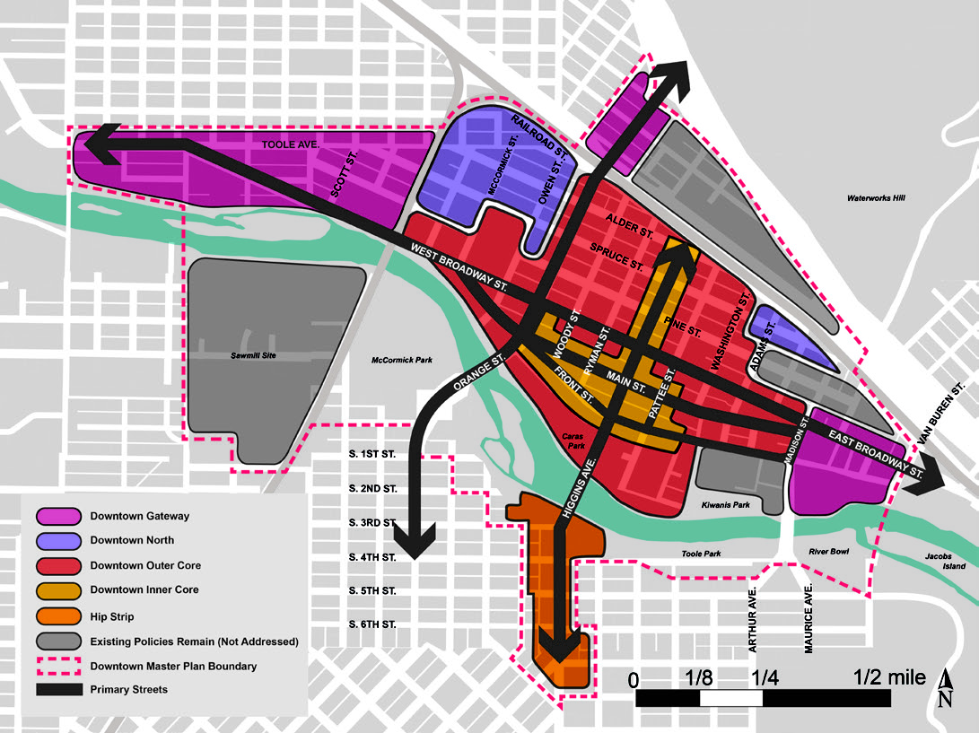
Map 20.25.080-1: Downtown Contexts Conceptual Map
c.
Corridor Typologies (/DE-C)
Select commercial corridors are classified into four different typologies. For each
typology, a community design vision is articulated. In the Design Standards (see 20.25.082), the prescriptive standards in many cases establish different requirements for different
typologies. In the Design Excellence Manual, the guidelines are more general, but
the vision established for each is to be used in administering the guidelines for
a given project.
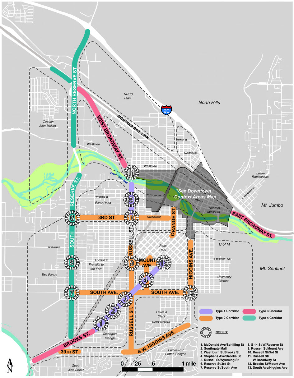
Map 20.25.080-2: Corridor Typologies Conceptual Map
3.
Overlay Applicability
a.
Project Applicability
(1)
Within the Design Excellence Overlay, application of the standards in this Section is required for any development for which Zoning Compliance Review is required in 20.85.130, except for detached houses, two-unit houses and townhouses.
(2)
Within the Design Excellence Overlay, the standards of this Section apply to:
(a)
New construction;
(b)
Redevelopment (including demolition of existing structures and modification of existing sites, including paving, parking and landscaping);
(c)
Additions; and
(d)
Modification of the building materials or window/door openings on a primary or secondary street-facing facade.
(3)
When the approval is for an addition or modification of the building, only the newly constructed or modified portion of the building and any associated modifications to the site are included in review under this Overlay.
(4)
Where development includes property within the Design Excellence Overlay, the entire project is subject to the requirements of the Overlay.
(5)
Where more than one subdistrict of the Design Excellence Overlay applies to a property or project, the design standards of each subdistrict apply as mapped on the official zoning map.
(6)
Ordinary maintenance and repair is exempt from the standards of this Section, including in-kind replacement of windows, doors and siding. Replacement of siding with types allowed in the Overlay is encouraged. Ordinary maintenance and repair of site elements such as parking lot sealing or re-striping and landscape replacement in-kind is also exempt from the standards of this Overlay.
b.
Application of Other Title 20 Standards
(1)
General
The Design Excellence Overlay is subject to the applicability provisions of 20.25.010 - General.
(2)
Enterprise Commercial
(a)
Where Enterprise Commercial Uses are allowed through conditional use review in a Business and Commercial District (20.10.020) or Industrial and Manufacturing District (20.15.020), they are exempt from conditional use review within the Design Excellence Overlay.
(b)
The following Enterprise Commercial (20.40.050) standards apply in the Design Excellence Overlays:
(i)
The Traffic Impact Analysis provisions of 20.40.050.B.
(c)
The remaining Enterprise Commercial standards do not apply in the Design Excellence Overlay.
(3)
/NC-SR Overlay
(a)
The following /NC-SR Overlay standards apply in the Design Excellence Overlays:
(i)
The additional allowed uses in 20.25.060.E.; and
(ii)
The prohibited uses banned in 20.25.060.F.
(b)
The remaining /NC-SR standards do not apply in the Design Excellence Overlay.
(4)
Multi-Dwelling BuildingDesign
(a)
The following multi-dwelling building standards apply in the Design Excellence Overlays:
(i)
Building height in 20.40.090.B.
(ii)
Pedestrian access in 20.40.090.C.
(iii)
Entry treatment in 20.40.090.E.1.
(iv)
Storage in 20.40.090.E.3.
(b)
The remaining design standards for multi-dwelling buildings do not apply in the Design Excellence Overlay.
(5)
Commercial Design Standards The standards of 20.40.170 - Commercial Uses Not Exceeding 30,000 Square Feet do not apply within the Design Excellence Overlay.
(6)
LandscapingStandards
(a)
The following Landscaping (20.65) standards apply in the Design Excellence Overlay:
(i)
The General Site Landscaping provisions of 20.65.020, except as specifically modified in 20.25.080.D.5.
(ii)
The Interior Parking Lot Landscaping provisions of 20.65.040, except as expressly modified in 20.25.080.C.3.g.
(iii)
The Buffer provisions of 20.65.060.
(iv)
The Screening provisions of 20.65.070.
(v)
The Landscape Material and Design provisions of 20.65.080.
(vi)
The Installation and Maintenance provisions of 20.65.090.
(b)
The following Landscaping standards do not apply in the Design Excellence Overlay:
(i)
The Street FrontageLandscaping provisions of 20.65.030, except as otherwise noted.
(ii)
The Perimeter Parking Lot Landscaping provisions of 20.65.050.
(iii)
The Alternative Compliance provisions of 20.65.100 (although a Design Variation may be requested - see 20.25.080.B.5).
(7)
Landscape Alternative Compliance
Landscape alternative compliance, as described in 20.65.100.B, is not allowed in the Design
Excellence Overlay; however, a Design Variation (20.25.080.B.5 Design Variation) may
be requested.
B.
Review Process
1.
General
The Design Excellence Overlay provides for several levels of review, as follows:
a.
Zoning Compliance Review for smaller projects in the Corridors and for projects that create or modify site improvements only.
b.
Design Excellence review by the Zoning Officer, in which design guidelines apply in addition to zoning standards.
c.
In particularly complex cases, when seeking relief through the Design Variation process, or when requested by the applicant, Design Excellence Review is conducted by the Design Review Board.
2.
Review Thresholds
a.
Zoning Compliance Review
Projects that fall below the Design Excellence Review thresholds in the table in paragraph
B.1.d. are reviewed using the Zoning Compliance Review process and the design standards
in this Section and 20.25.081 or 20.25.082, respectively.
b.
Design Excellence Review
(1)
Design Excellence Review is required for all Downtown subdistricts, Corridor Typology 1 and all Corridor Nodes.
(2)
Design Excellence Review thresholds in Corridor Typologies 2, 3 and 4 are based on the gross square footage of all structures added or modified.
(3)
Design Excellence Review is required for conditional uses, height above the base zoning, and design variations.
THRESHOLDS FOR DESIGN EXCELLENCE REVIEW
* Enterprise commercial is not a conditional use in the Design Excellence Overlay.
3.
Zoning Compliance Review
a.
Review and Decision - Zoning Officer
(1)
Where Zoning Compliance Review is required in 20.25.080.B.1.a, the Zoning Officer must review each building permit application and act to approve or deny the Design Excellence Review based solely on whether the proposed structure or development complies with:
(a)
The design standards of this Section and 20.25.081 or 20.25.082, respectively; and
(b)
All other applicable provisions of the Zoning Ordinance.
(2)
The Design Excellence Manual is for information only, and not a requirement of Zoning Compliance Review.
(3)
No notice is required for Zoning Compliance Review.
(4)
Appeals of the decision of the Zoning Officer follow the procedure for review by the Board of Adjustment in 20.85.100.
4.
Design Excellence Review
a.
General
(1)
Purpose
The purpose of Design Excellence Review is to ensure the quality of development in the Downtown and select corridors. The Overlay standards combined with the design
guidelines are intended to support creativity and flexibility in meeting the City's
vision and urban design objectives. The design standards of this 20.25.080, and either 20.25.081 or 20.25.082, along with the applicable design guidelines in the accompanying Design Excellence
Manual will be applied during development review.
(2)
Authority
(a)
Design Excellence Review is conducted administratively by the Zoning Officer.
(b)
Design Excellence Review is conducted by the Historic Preservation Commission or the Historic Preservation Officer where the project involves a Historic Resource.
(3)
Common Review Procedures
Design Excellence Review is subject to the Common Provisions of 20.85.020.A. through
C.
(4)
Review and Decision-Making Criteria; Burden of Proof or Persuasion
Design Excellence Review is subject to the Review and Decision-Making Criteria; Burden
of Proof or Persuasion provisions of 20.85.030.
b.
Timing of Design Excellence Review
(1)
Where required, Design Excellence Review must occur before any structure, or part of a structure may be created, erected or changed, wholly or in part, in its construction. While a building permit application may be submitted and review conducted concurrently, such an application may need modification following design review, and prior to issuance of the building permit. For this reason, it is preferred that a separate application for review of project design be approved prior to submission of a building permit application.
(2)
Where Design Excellence Review is conducted for a conditional use, such approval is required prior to conditional use approval.
c.
Applications
(1)
Pre-Application Meeting
A pre-application meeting is highly recommended, although not required. Please contact
the Zoning Officer to schedule a pre-application meeting.
(2)
Authority to File
Applications for Design Excellence Review may be initiated only by the owner of the
subject property or by the owner's authorized agent.
(3)
Notices
(a)
No notice is required for Design Excellence Review by the Zoning Officer.
(4)
Forms
Applications required under this Overlay must be submitted in a form and in such numbers
as required by the Zoning Officer. Application forms and checklists of required submittal
information are available at Development Services.
d.
Review and Decision - Zoning Officer
The Zoning Officer must review each application and act to approve or deny the Design
Excellence Review based solely on whether the proposed structure or development complies with:
(1)
The design standards of this Section and 20.25.081 or 20.25.082, respectively;
(2)
All other applicable provisions of the Zoning Ordinance; and
(3)
The applicable design guidelines in the accompanying Design Excellence Manual.
e.
Use of Design Excellence Manual
The design guidelines are qualitative and focus on broader design objectives. The
design guidelines are intended to allow for flexibility in how a project meets them,
and as such, discretion and interpretation are required to determine when a project
is consistent with the guidelines. The guidelines in this document include intent
statements under each topic. These statements describe the desired design objective.
More specific guidelines follow each intent statement.
f.
Appeals
Zoning Officer decisions of noncompliance with the Design Excellence Overlay may be
appealed to the Board of Adjustment. Such applications will be considered by the Board
of Adjustment based on the record, including the application materials submitted previously
and the decision of the Zoning Officer. An appeal may be sustained only if the Board
of Adjustment finds that the Zoning Officer erred in determining the project was not
compliant.
5.
Design Variation
a.
General
(1)
A Design Variation allows a project to use an alternative design approach to satisfy a particular design standard in this Section. The alternative design approach must satisfy the specified intent of the particular design standard.
(2)
A Design Variation is only allowed for design standards in 20.25.080.C, 20.25.081 or 20.25.082, respectively.
(3)
A Design Variation is not a variance, which provides relief from a requirement considered to be an unnecessary hardship. The Design Variation is required to meet the intent of the applicable standard in an alternative way.
b.
Design Variation Review
(1)
Applicants may seek a Design Variation through Design Excellence Review.
(2)
Applicants may apply for a Design Variation even when Design Excellence Review is not required; however, the request will trigger Design Excellence Review for the entire project.
(3)
A Design Variation allows a project to use an alternative design approach to satisfy a particular design standard in 20.25.080.C, 20.25.081 or 20.25.082, respectively. The alternative design approach must satisfy the specified intent of the particular design standard.
(4)
The Zoning Officer will use the design guidelines in the Design Excellence Manual to determine whether an alternative design approach appropriately satisfies the intent of the design standard.
(5)
Design Variation review occurs concurrent with Design Excellence Review. A Design Variation may be submitted during the Design Excellence Review process where it resolves an issue identified during review.
(6)
Following approval of a project, no further Design Variation is allowed, and changes must be made through either a new review of the entire project or through the Variance process.
C.
Standards, Interpretation
1.
Introduction
a.
Location, Interpretation of Design Standards
The following paragraphs explain the location and applicability of the design standards
for all districts in 20.25.080.C.2, as well as the specific design standards that
apply in various Downtown and Corridor subdistricts in 20.025.081 and 20.025.082.
In addition, the interpretation of the various design standards is enhanced through
the rules of interpretation in 20.25.080.C.3 through C.7. below.
(1)
Design Standards for All Districts
20.25.080.C.2. contains design standards and interpretations that apply in all the
Design Excellence Overlay subdistricts, except where expressly stated otherwise in
the Applicability text of the specific design standard.
(2)
Subdistrict Design Standards
The subdistrict design standards are found in 20.25.081 and 20.25.082. This 20.25.080.C. must be used in conjunction with these subdistrict-specific standards
to determine applicability of each standard, measure each specific standard, and interpret
the intent of each specific design standard.
(3)
Rules for Interpretation
(a)
20.25.080.C.3 through C.7. below include the following components:
(i)
Design standard definitions.
(ii)
Design standard intent for consideration in Design Variation requests.
(iii)
Design standard applicability.
(iv)
Detailed design standards.
(v)
Rules for design standard measurement.
(b)
The Design Excellence Manual may also be used to interpret the intent of any design standard.
2.
General Standards
a.
Primary Streets
(1)
Definition
High priority streets in Downtown and Corridors where maintaining an urban environment
is particularly important.
(2)
Downtown Primary Streets
The Downtown Master Plan identifies a series of streets where street level interest
and a clearly-defined street wall should be emphasized. These Primary Streets are
indicated on Map 20.25.080-1 and include:
(a)
Broadway Street;
(b)
Main Street;
(c)
Front Street;
(d)
Orange Street;
(e)
Woody Street;
(f)
Ryman Street;
(g)
Higgins Avenue;
(h)
Pattee Street;
(i)
Madison Street.
(3)
Corridor Primary Streets
As part of the Design Excellence project, the following Corridors are considered Primary
Streets. The Corridor Primary Streets are indicated on Map 20.25.080-2.
(a)
Brooks Street;
(b)
Russell Street;
(c)
South Avenue;
(d)
West 3rd Street;
(e)
Higgins Avenue;
(f)
Mount Avenue;
(g)
SW Higgins Avenue;
(h)
39th Street;
(i)
East Broadway Street;
(j)
Reserve Street;
(k)
West Broadway;
(l)
Stephens Avenue.
b.
Primary Street Property line
(1)
Definition
A primary street property line is a property line separating a parcel from a designated Primary Street right-of-way or a property line separating a parcel from an undesignated street determined to be primary.
(2)
Standards
(a)
Standards specified for primary streets apply to property lines designated as primary street property lines.
(b)
Each parcel in the Downtown must have at least one primary street property line.
(c)
In the Corridors, only those streets designated as Primary Streets have a primary street property line. All other streets following the rules for Secondary Streets, except in the case of a through lot.
(d)
Parcels abutting more than one mapped primary street have more than one primary street property line.
(e)
Once designated for a parcel, a primary street property line cannot be changed (e.g., a primary street property line cannot, for purposes of subsequent development, be re-designated a secondary street property line) unless all requirements of the applicable Design Excellence Overlay subdistrict can be met by existing development on the site.
(f)
For parcels in the Downtown that abut multiple streets, none of which have been mapped as primary streets, a primary street property line is determined using the following criteria:
(i)
The street or streets with the highest functional classification;
(ii)
The established orientation of the block;
(iii)
The street abutting the longest face of the block;
(iv)
The street parallel to an alley within the block;
(v)
The street that the parcel has historically taken its address from;
(vi)
The pedestrian orientation of adjacent or abutting development, existing or proposed;
(vii)
Whether the street faces an important open space.
c.
Secondary Street Property line
(1)
Definition
A secondary street property line is a property line separating a parcel from a street right-of-way not designated as a primary street.
(2)
Standards
Standards specified for secondary streets apply to property lines designated as secondary street property lines.
d.
Primary and Secondary Street Interpretation
Where there is a question of interpretation, the Zoning Officer will determine the
primary and secondary street standards to be applied to the affected properties.
e.
Vehicular Access
(1)
Definition
This standard regulates the location and width of vehicular access driveways onto
a property.
(2)
Intent
The number, location and width of driveways directly affects safety and walkability.
Standards limiting vehicular access are intended to reduce potential conflicts between
pedestrians, bicyclists and vehicles and improve the comfort of sidewalks and roadways
for pedestrians and bicyclists.
(3)
Standards
(a)
Final determination on access is made by the City Engineer. Where feasible, access is preferred from the alley or secondary street.
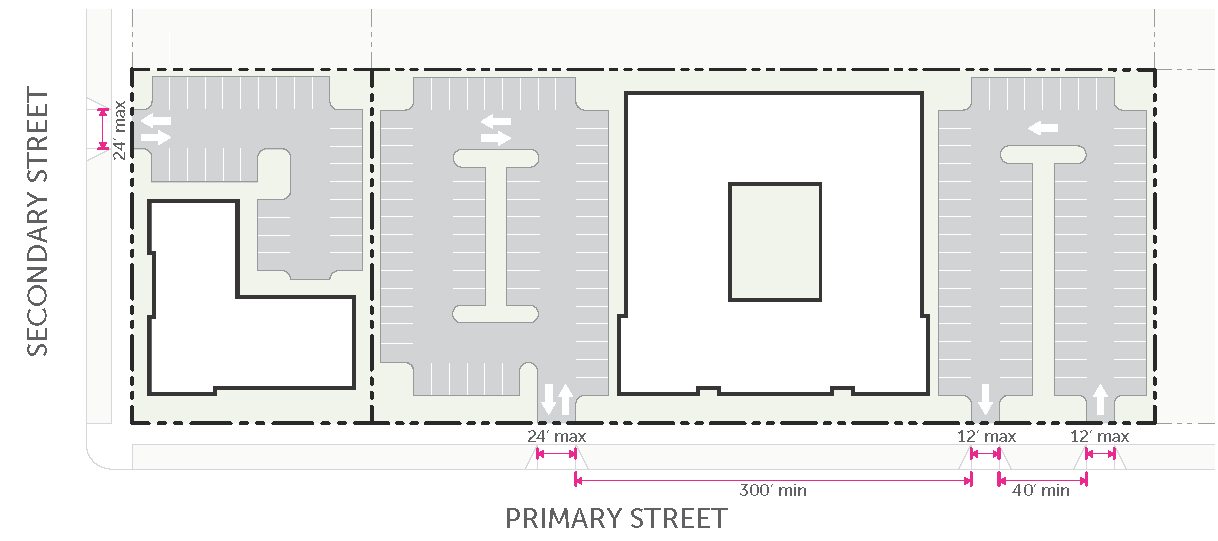
(b)
Driveways on primary and secondary streets must be no more than 12 feet wide for a one-way drive and no more than 24 feet wide for a two-way drive.
(c)
One-way driveways must be separated by a minimum of 40 feet.
(d)
Properties taking access from primary and secondary streets are limited to one two-way drive or one pair of one-way drives for every 300 feet of parcel frontage.
(e)
These standards may be waived or modified at the discretion of the City Engineer.
f.
Build-To Area Character
(1)
Definition
The build-to area is considered that area lying between the back of sidewalk (or edge
of right-of-way where no sidewalk exists) and that portion of the building face that
lies within the build-to zone.
(2)
Standards
(a)
Where space is available, the sidewalk must be located in the right-of-way. Where additional space is required to accommodate the desired right-of-way facilities, the build-to area must be used to supplement the substandard right-of-way and a public access easement will be required.
(b)
This determination will be made by the Zoning Officer, based on current area plans and adopted streetscape standards and engineering codes, which may indicate the preferred cross-section for sidewalk width and space for landscaping or hardscaping.
(c)
Where a portion or all of the build-to area is required for a sidewalk adjacent to a substandard right-of-way, the Zoning Officer must adjust the maximum setback to allow at least five feet between the back of sidewalk and the maximum setback.
(d)
Remaining portions of the build-to area that are not covered by structures, or paved for driveways or parking areas, must contain one or more of the following:
(i)
Landscaped areas (see 20.65.030.C.4. - Street FrontageLandscaping).
(ii)
Hardscaped plazas (including, but not limited to, pavers, cut stone or colored cement). Plazas must be unenclosed exterior space with public pedestrian access, and must not include areas used for vehicles, except for incidental service, maintenance or emergency access.
(iii)
Increased sidewalk or boulevard area.
g.
Sidewalks
(1)
Internal pedestrian walkways must be a minimum of five feet in width.
(2)
For any non-residential building over 30,000 square feet in gross floor area, internal sidewalks along any building face that contains the primary building entrance must be a minimum of eight feet in width.
3.
Site Standards
a.
Street Setback
(1)
Definition
The location beyond which buildings may be placed. This concept is used only when no Build-To Zone applies.
(2)
Intent
The intent is to allow maximum flexibility in building placement on the parcel.
(3)
Standards
(a)
No structure may be located between a street setback and the street with the exception of allowed encroachments in 20.110.050.D.
(b)
The street setbacks established in 20.25.081 and 20.25.082 supersede any street setbacks of the underlying zoning.
b.
Build-To Zone
(1)
Definition
The area on a parcel between the minimum and maximum setbacks that the primary building is required to occupy.
(2)
Intent
To regulate the placement of buildings along a street such that:
(a)
The public right-of-way is framed by a legible and consistent street wall.
(b)
There is a strong visual and physical connection between the private and public realm.
(c)
There is adequate space between ground floor uses and high-speed roadways.
(d)
Buildings create visual interest along a sidewalk.
(e)
Buildings enhances pedestrian comfort.
(3)
Applicability
(a)
For a property with a single street frontage, the build-to zone applies to that frontage.
(b)
For a corner parcel with two frontages, the build-to zone applies to both the primary street and secondary street frontages.
(c)
For a parcel that has two street frontages (such as a "through-lot") and is not a corner parcel, the build-to zone applies to the property line adjacent to the designated primary street in 20.25.080.C.2.a. above.
(d)
For a property with three or more street frontages (such as a "full-block" parcel), the build-to zone is only applied to two frontages that create a corner.
(4)
Standards
(a)
The build-to zone supersedes any minimum setback established in the base zoning district. The minimum build-to line is considered the minimum setback in the Design Excellence subdistricts.
(b)
No structure may be located between a minimum setback and the street.
(c)
Once the minimum build-to width has been met, portions of the building, or additional buildings on the site, may be placed outside the build-to zone (beyond the maximum setback).
(d)
On a corner parcel, the primary building must be placed on or within the area where the build-to range of the two intersecting streets overlap. The building facade must be placed on or within the build-to range for a minimum of 30 feet in both directions.
(5)
Nonconforming Build-To: New Buildings
(a)
All new buildings must be placed in the build-to zone until the required percentage for the parcel has been met.
(b)
Once the required percentage has been met for the parcel, new buildings may be placed outside of the build-to zone.
(6)
Nonconforming Build-To: Additions
(a)
Front Additions
(i)
Any addition to the front of an existing building must be placed in the build-to zone. The addition does not have to meet the required percentage for the entire parcel.
(ii)
Front additions no greater than 10% cumulatively of the existing building footprint are allowed outside of the build-to zone.
(b)
Side Additions
Side additions no greater than 20% cumulatively of the existing building footprint
are allowed outside of the build-to zone. Once the required percentage for the parcel has been met, side additions of any size are allowed.
(c)
Rear Additions
(i)
Rear additions are allowed outside of the build-to zone.
(ii)
Rear additions on corner lots where the secondary street does not meet the build-to requirement must include additional street planting to screen the side street for the width of the existing and expanded building. The screening must consist of a 10-foot landscape strip planted with trees every 30 feet on center and landscaped with shrubs.
c.
Build-to Width
(1)
Definition
The minimum cumulative building width that must occupy the build-to zone, based on
the width of the parcel at the street.
(2)
Intent
To regulate the width of buildings along a street such that the public right-of-way is framed by a legible and consistent
street wall, and there is a strong visual and physical connection between the private
and public realm.
(3)
Standards
(a)
The minimum build-to width indicated in a Design Excellence Overlay subdistrict specifies the cumulative building width that must occupy the build-to range.
(b)
When providing a driveway prohibits a building from achieving the required build-to width, a build-to width less than the subdistrict requirement may be allowed by the Zoning Officer, provided the following:
(i)
The driveway is the minimum width allowed;
(ii)
The building conforms to the applicable build-to width standard to the greatest extent possible;
(iii)
Automobile access to the parcel is required by the City Engineer to be taken from the Primary or Secondary Street.
(c)
Where the minimum build-to width is listed as not applicable (n/a), there is no minimum requirement for a building of any specific width. The applicant may choose their preferred building width, provided it does not exceed the maximum building width allowed for the subdistrict.
(4)
Measurement
The build-to width is measured as the sum of all building widths occupying the build-to
range, measured parallel to the applicable primary or secondary street property line, divided by the total width of the parcel at the street.
(5)
Phased Development
When multiple buildings on the property will be developed in phases, and the initial phase of development would not meet the required build-to width, the applicant must designate a reserve
area along the street frontage for future building phases that would allow the project to comply with the build-to
width, provided the following conditions are met:
(a)
The reserve area must include the entire property frontage abutting the primary street or secondary street for a depth of no less than 60 feet.
(b)
Parking of vehicles, water quality facilities, detention/retention facilities, and utilities are not allowed within the reserve area.
(c)
The reserve area must be landscaped (see 20.65.020).
(d)
Required pedestrian access and circulation through the reserve area must be provided.
d.
Building Width
(1)
Definition
The maximum width of any individual building or the cumulative width of physically connected structures within a development site.
(2)
Intent
To promote a fine-grained pattern of development even on large properties and to prevent long buildings that are significantly out of context with the traditional pattern of development.
(3)
Measurement
Building width is measured parallel to each street property line.
e.
Parking Between Buildingand Street
(1)
Intent
(a)
Where parking is not allowed between the building and the street, the intent is to promote a streetscape with a high level of pedestrian interest and comfort and increase the visual and physical connection between a building and the public right-of-way.
(b)
Where parking is allowed between the building and the street, the intent is to allow maximum building siting flexibility in sites with limited expectation of pedestrian activity.
(2)
Standards
(a)
Prohibited
Where a Design Excellence Overlay subdistrict indicates that parking between a building and the street is prohibited, no parking or vehicular use areas may be located between a street facing building facade within 60 feet of a street
and the associated street property line.
(b)
Limited
Where a Design Excellence Overlay subdistrict indicates that parking between a building and the street is limited, a maximum of one double row of parking and its associated
drive aisle is allowed.
f.
Parking Setbackfrom Street
(1)
Intent
To minimize the impact of automobile dominated areas on the public right-of-way and
to promote a comfortable, safe, engaging and attractive streetscape.
(2)
Standards
All surface and structured parking and vehicular use areas must be set back from the street property line the minimum dimension indicated in the applicable subdistrict.
(3)
Measurement
Parking setback from street distances are measured perpendicularly from the street property line.
g.
Interior Parking Lot Landscaping
(1)
Definition
Landscaping required within surface parking lots in addition to the landscaped island requirements
of 20.65.040.C.2.
(2)
Intent
To increase permeable surfaces, break-up large surface parking areas, reduce noise
and glare, and moderate heat.
(3)
Applicability
(a)
All surface parking lots with at least three parallel drive aisles.
(b)
The landscaped island requirements of 20.65.040.C.2 continue to apply in addition to this interior parking lot landcsaping standard.
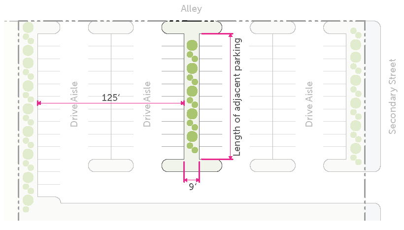
(4)
Standards
(a)
Provide a landscaped area at least nine feet wide between rows of parking.
(b)
Spaced a maximum of 125 feet from a perimeter parking lot screening landscaped area or another interior parking lot landscaping area.
(c)
Landscaped area must be continuous for the length of the adjacent rows of parking.
(d)
Planted in with two trees and 12 shrubs per 1,000 square feet of landscaped area and groundcover in accordance with 20.65.040.
(5)
Measurement
(a)
Interior parking lot landscaped area width is measured from the outside edge of the curb.
(b)
Maximum spacing is measured perpendicular to the outside edge of the curb.
h.
Perimeter Parking Lot Screening
(1)
Definition
Minimum requirements for screening parking and other vehicular use areas from a street.
(2)
Intent
To minimize the impact of automobile-dominated areas on the public right-of-way and
to promote a comfortable, safe, engaging and attractive streetscape.
(3)
Applicability
(a)
All surface parking lots adjacent to a public street.
(b)
Perimeter parking lot screening is required for vehicular use areas located within 60 feet of the street property line.
(c)
These standards apply in place of the perimeter parking lot landscaping requirements in 20.65.050.
(4)
Standards
(a)
Where required, one or more of the following parking lot buffers must be provided:
| LandscapeHedge: | 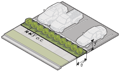 | |
| Landscape area width (min.) | 6' | |
| Shrub height (min.) | 3' | |
| Shrub spacing (max.) | 3' on-center | |
| LandscapeWall: | 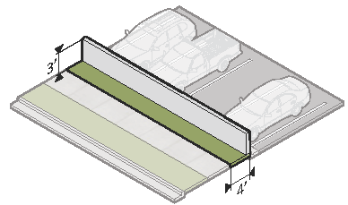 | |
| Landscape area width (min.) | 4' | |
| Wall height (min.) | 3' | |
| Grade Change: | 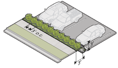 | |
| Landscape area width (min.) | 3' | |
| Finished grade change (min.) | -3' | |
| Shrub height (min.) | 3' | |
| Shrub spacing (max.) | 3' on-center | |
| Landscape Berm*: | 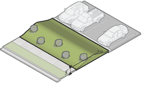 | |
| Berm height (min.) | 3' | |
| Slope (max.) | 3:1 | |
| * Allowed only in Corridor Typology 3 and 4 | ||
(b)
Screening elements such as a wall or hedge must be placed to the interior of the site.
(c)
Parking lot perimeter screening may be provided in a required parking setback.
4.
Vertical Scale
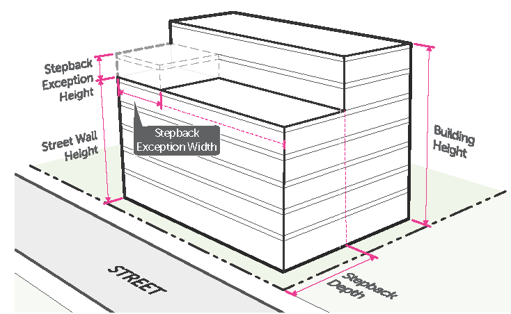
a.
Building Height
Design Excellence Overlay subdistricts do not limit maximum building height. Building
height is controlled by the underlying zoning.
b.
Street Wall Height
(1)
Definition
The height in number of stories and feet that may be built adjacent to a street without
including an upper story stepback.
(2)
Intent
To open up access to air and light by reducing the perceived scale of a building at
the street level.
(3)
Standards
(a)
Any building height greater than the maximum street wall height listed in a Design Excellence Overlay subdistrict must be set back by the minimum stepback depth dimension indicated in the applicable subdistrict. Street wall height is measured in both feet and stories, and is not allowed to exceed either standard.
(b)
Where the maximum street wall height is greater than the maximum building height in the underlying zoning, the underlying zoning standard prevails. Greater height up to the maximum street wall height may be allowed as a Design Variation through Design Excellence Review by the Zoning Officer.
c.
Stepback Depth
(1)
Intent
To assure an appropriate height along the street, while allowing the rest of the building to meet the maximum building height established in the base zoning.
(2)
Standards
Portions of a building above the maximum street wall height must be set back from the street property line the minimum distance listed in the applicable subdistrict.
d.
Stepback Exception
(1)
Definition
The maximum height and width of building that may deviate from the maximum street wall height and stepback depth standards.
(2)
Intent
To provide sufficient relief from stepback depth and street wall height standards
to allow minor vertical architectural elements that do not substantially alter the
perceived scale of a building from the public right-of-way.
(3)
Standards
A building may deviate from the maximum street wall height and stepback depth for the height
and width indicated in the applicable subdistrict.
(4)
Measurement
(a)
Stepback exception width is measured as the cumulative building width deviating from the maximum street wall height or stepback depth divided by the total building width.
(b)
Stepback exception height is measured vertically from the maximum street wall height.
e.
Floor-to-Ceiling Height (Ground Floor)
(1)
Definition
The minimum height for the first story of a building. Does not apply to a basement.
(2)
Intent
To ensure ground floor building heights that are adequate to support high quality space for tenants, activate
the public realm, and reflect historic ground floor heights.
(3)
Standard
The ground floor of a building must meet the minimum floor-to-ceiling height listed in the applicable subdistrict
for a minimum depth of 30 feet into the building from any street facing facade.
(4)
Measurement
Ground floor height is measured vertically from the top of the finished ground floor to the lowest ceiling surface above.
5.
Facade Design
a.
Glazed Area
(1)
Definition
The amount of transparent glass on ground and upper floor street-facing building facades.
(2)
Standards
(a)
Window and door glass meeting the following transparency standards counts as glazed area:
(i)
Visible light transmittance of 60% or more.
(ii)
External reflectance of 20% or less.
(b)
In addition to door and window glass, muntins, mullions, window sashes, window frames and door frames no more than three inches wide may be considered glazed area when a part of a window or door assembly with glazing meeting the requirements above.
(c)
Interior walls and other interior visual obstructions are not allowed within six feet of any facade area counting toward glazed area. This distance is measured perpendicularly from the exterior face of the glazed area.
(d)
Interior security gates and window displays may obstruct a maximum of 25% of window area for any individual window counting toward glazed area.
(e)
In the event that these glazed area requirements conflict with City building or energy code requirements, the Zoning Officer, in consultation with the Building Official, may reduce the required amount of glazing.
b.
Ground FloorGlazed Area
(1)
Definition
The amount of transparent glass on a ground floor street-adjacent building facade.
(2)
Applicability
Only street-facing building facades must meet ground floorglazed area standards.
(3)
Intent
To provide visual interest along the sidewalk, passive surveillance of the public
realm and visual connection from the public realm to the inside of a building.
(4)
Measurement
Ground floorglazed area is calculated as the total glazed area between two feet and 10 feet above finished grade divided by the total facade area between two feet and 10 feet above finished grade.
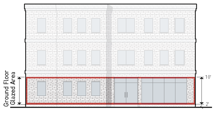
(5)
Standards
(a)
The ground floor building facades of a building must meet the minimum glazed area percentage listed in the applicable subdistrict.
(b)
Glazed area must meet the glazed area standards in 20.25.080.C.5.a.
c.
Upper Floor Glazed Area
(1)
Definition
The amount of transparent glass on an upper floor street-adjacent building facade.
(2)
Applicability
Only street-facing building facades must meet upper floor glazed area standards.
(3)
Intent
To provide the public realm with visual interest and passive surveillance.
(4)
Measurement
Upper floor glazed area is calculated as the total glazed area between the finished floor of each upper floor to the finished floor of the upper
floor above.
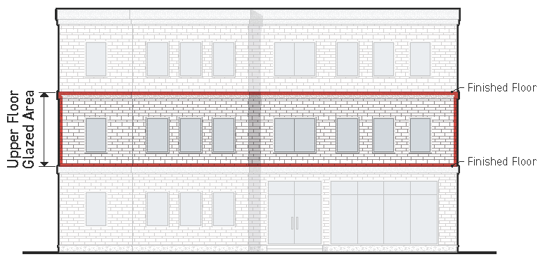
(5)
Standards
(a)
An upper floor building facade must meet the minimum glazed area percentage listed in the Design Excellence Overlay subdistrict.
(b)
Glazed area must meet the glazed area standards in 20.25.080.C.5.a.
d.
Upper Floor Blank Wall Width
(1)
Definition
The maximum linear space allowed between windows on an upper floor building facade.
(2)
Intent
To prevent large monotonous wall planes along the public realm, distribute windows
and their associated benefits across the width of a building.
(3)
Applicability
Only street-facing building facades between the second finished floor and the maximum
street wall height must meet upper floor blank wall standards.
(4)
Standard
An upper floor building facade must meet the minimum blank wall width listed in the
applicable subdistrict.
(5)
Measurement
Upper floor blank wall width is measured horizontally for any individual length of
building wall that does not include glazed area between three feet and seven feet from the finished floor.
e.
Street-Facing Entrance
(1)
Definition
A door providing access from the public sidewalk to the first habitable story of a
building.
(2)
Intent
Enhance walkability and provide visual and physical connections between a site and
the public realm.
(3)
Standards
Entrances qualifying as a street-facing entrance must meet the following standards:
(a)
Provide both ingress and egress access to the first floor of a building (not the basement).
(b)
Operable for residents or tenants at all times.
(c)
Facing the public sidewalk.
(d)
Not providing access to parking, utility areas or fire stairs.
(e)
On a corner parcel, an entrance angled between 30 to 60 degrees may be provided at the building corner near the street intersection to meet a street-facing entrance requirement for both streets.
(f)
Each required street-facing entrance must connect to the public sidewalk with a direct pedestrian connection that is physically separated from vehicular use areas and uninterrupted by parking except where required to cross a drive aisle.
(g)
Direct pedestrian connections must be at least five feet wide and located within 25 feet of the center of the street-facing entrance when measured parallel to the sidewalk.
f.
Distance Between Entries
(1)
Definition
The maximum distance allowed between street-facing entrances.
(2)
Intent
Concentrate pedestrian activity on the public sidewalk and provide a strong connection
between buildings and the public realm.
(3)
Applicability
(a)
The maximum entrance spacing requirements must be met for each building, but do not apply to adjacent or abutting buildings.
(b)
Maximum distance between entries only apply to street-facing facades.
(4)
Standards
(a)
Street-facing entrances must be provided at the frequency listed in the applicable subdistrict.
(b)
On a corner parcel where the building width along a secondary street is greater than the required distance between entries, a secondary street entrance is required.
(5)
Measurement
The maximum distance between entries is measured parallel to the street property line from the edge of door to edge of door and edge of door to edge of building.
6.
Articulation
a.
Mass Variation
(1)
Definition
A substantial change in mass, clearly legible as a deviation from the massing along
the other street-facing portions of a building.
(2)
Intent
To provide visual interest and a human-scale to otherwise large and monotonous building
facades through the use of design features that break a large building mass into different,
clearly identifiable elements.
(3)
Applicability
Mass Variation standards apply to primary and secondary street-facing building facades
longer than 50 feet.
(4)
Standard
(a)
When required, all applicable building facades must meet the standards for at least one mass variation method.
(b)
Multiple building widths using the same mass variation technique may be added together to meet the minimum building width for the mass variation standards.
(c)
Mass variation applies to single-story buildings.
(5)
Measurement
The percentage of building width with mass variation is calculated as the building
width meeting the standards of a mass variation method divided by the total width
of the building.
(6)
Mass Variation Methods
Meeting the standards for one of the following mass variation methods counts as meeting
the requirement for mass variation:
(a)
Height Variation
A significant change in height for a significant depth of the building.
(i)
The minimum allowed building width without a height variation is 30% of the total building width.
(ii)
The maximum allowed building width without a height variation is 70% of the total building width.
(iii)
Vary in height a minimum of eight feet from the rest of the building width.
(iv)
Minimum width of 10 feet.
(v)
Must be conditioned (habitable) space.
(vi)
Minimum depth of a height variation is 65 feet or the full building depth, whichever is less.
(b)
Increased Setback
A significant variation in setback along the width of a building.
(i)
A minimum of 30% and a maximum of 70% of the building width must be set back from the rest of the building width.
(ii)
Increased setback area must be set back at least five feet for a minimum width of at least 15 feet.
(c)
Upper Floor Stepback
Upper floors of a building set back significantly from the lower floors of a building for the remaining height of a building.
(i)
A minimum of 70% of the building width must include an upper floor stepback.
(ii)
Upper floors must be set back from the lower floors a minimum of 10 feet for all building widths counting as having an upper floor stepback.
(iii)
Lower floor must include at minimum the ground floor and the second floor. The upper story stepback must occur between the third floor and the maximum street wall height.
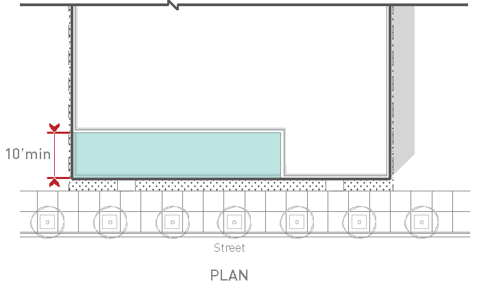
D.
Incentives
1.
General
a.
Intent
The intent of these incentives is to encourage development in the Design Overlay areas by reducing or removing certain Title 20 development requirements, while promoting the community vision for Downtown and the
Corridors.
b.
Availability
Incentives in this Section are available based on the applicability stated in each
credit or reduction below. Reductions are allowed in amounts that vary by subdistrict.
c.
Design Variation
Design flexibility through the Design Variation review process is also available as
an incentive to apply the design guidelines in place of a specific prescriptive design
standard in the Design Excellence Overlay. See 20.25.080.B.3.
2.
On-Street Parking Substitution
a.
On-street parking substitution is allowed in order to meet the zoning requirements for both residential and non-residential projects in the Downtown Gateway, Downtown North, Downtown Hip Strip, and Corridor Typology 1, 2 and 3.
b.
Where on-street parking spaces with a minimum dimension of at least 23 feet in length exist in the public right-of-way, one on-street parking space may be substituted for every required on-site parking space, provided the on-street space immediately abuts the subject property.
c.
Each on-street parking space may only be counted for one property. Where an on-street parking space straddles an extension of a property line, the space may only be counted by the owner whose property abuts 50% or more of the on-street parking space.
d.
ADA parking spaces, if required, must be provided on-site.
e.
The Zoning Officer will determine if the credit for on-street parking spaces is appropriate based on area plans and adopted streetscape standards to ensure that the on-street parking spaces will exist into the foreseeable future. The Zoning Officer may determine that to ensure future roadway capacity, the on-street parking credit is not available.
3.
Parking for Adaptive Reuse
a.
No parking is required for the adaptive reuse for non-residential purposes of any existing building (but not an addition or new construction) in the Design Excellence Overlay that is both:
(1)
Under 4,000 square feet in gross floor area; and
(2)
At least 50 years old as of the date of any application for development review.
b.
The burden of proving the building's age is on the applicant.
c.
Any existing parking associated with the building must be retained.
4.
Off-Street Parking Reduction
a.
Maximum Reduction
(1)
Any off-street parking reduction allowed in this Overlay is calculated based on the final parking requirement following the standards in 20.60.
(2)
The maximum parking reduction allowed through 20.60 and this Overlay is 50% of the overall parking reduction according to 20.60 and does not duplicate reductions.
(3)
The parking exemption in 20.25.080.D.3. is not a parking reduction subject to this limitation.
b.
Small Non-Residential Use Parking Reduction
(1)
This incentive is available in the Downtown Gateway, Downtown North, Downtown Outer Core, Downtown Hip Strip, and Corridor Typology 1 and 2.
(2)
No off-street parking spaces are required for the first 1,500 square feet of non-residential space in a project (whether adaptive reuse of an existing building or new construction).
(3)
Uses greater than 1,500 square feet must provide parking only for the floor area in excess of 1,500 square feet.
(4)
On properties occupied by two or more uses, the reduction may only be applied once.
c.
Transit-Served Location Parking Reduction
(1)
This incentive is available in the Downtown Hip Strip, Downtown Gateway, Downtown North, and Corridor Typology 1, 2 and 3.
(2)
In the Downtown Hip Strip, Downtown Gateway, Downtown North, and Corridor Typology 1 and 2, projects located within 1,250 feet of a transit stop may reduce the required off-street parking spaces by up to 15%.
(3)
In Corridor Typology 3, projects located within 1,250 feet of a transit stop may reduce the required off-street parking spaces by up to 10%.
(4)
Staff will evaluate the quality of the transit stop design and the adequacy of the connectivity between the transit stop and the project using the existing criteria in 20.85.110.B.8. to ensure:
(a)
The transit stop operates at an adequate level of service; and
(b)
The transit stop is conveniently located and connected to the development.
d.
Bike-Served Location Parking Reduction
(1)
This incentive is available in the Downtown Gateway, Downtown North, Downtown Outer Core, Downtown Hip Strip, and Corridor Typology 1, 2 and 3.
(2)
In the Downtown Gateway, Downtown North, Downtown Outer Core, Downtown Hip Strip, and Corridor Typology 1 and 2, any use located adjacent to a designated bicycle lane may reduce the required off-street parking spaces by up to 20%.
(3)
In Corridor Typology 3, any use located adjacent to a designated bicycle lane may reduce the required off-street parking spaces by up to 15%.
(4)
The connection to the bicycle route or trail will be evaluated to ensure there is convenient access from the development.
e.
Bike Parking Reduction
(1)
This incentive is available in the Downtown Gateway, Downtown North, Downtown Outer Core, Downtown Hip Strip, and Corridor Typology 1, 2 and 3.
(2)
Required off-street parking spaces may be reduced by one space for every four bicycle parking spaces (short-term or long-term bike parking spaces) provided in excess of the requirement in 20.60.090.
(3)
This credit may be used to reduce the total required off-street parking spaces no more than 25%.
(4)
The bike parking spaces must meet the design guidelines for bicycle amenities in the Design Excellence Manual and 20.60.090 in terms of quality and location.
5.
LandscapingReduction
a.
General Site Landscaping
(1)
This incentive is available in the Downtown Gateway, Downtown North, Downtown Hip Strip, and Corridor Typology 1, 2, 3 and 4.
(2)
The minimum landscaped area requirements as a percentage of the property size identified in 20.65.020.B.2. may be reduced to 15% of the gross area of the property, except as noted for Vertical Mixed Use, addressed in 20.25.080D.6 below.
(3)
Staff will use the design guidelines in the Design Excellence Manual applying best practices to the specific site to determine if the quality of the provided landscape area qualifies for receipt of this Regulatory Improvement.
6.
Vertical Mixed Use
a.
No Density Restriction
There is no minimum parcel area per dwelling unit requirement for a Vertical Mixed-Use Building meeting the definition in 20.100.010.
b.
Compliance with 20.65.020, General Site Landscaping, is not required for Design Excellence Downtown Inner Core, Outer Core, and Hip Strip Overlay subdistricts.
c.
In all other Design Excellence Overlays, the provision of 15% of the parcel area for the purpose of General Site Landscaping may be waived in exchange for alternative requirements found in 20.65.020.A.3 Exceptions.
7.
Activity Area Reduction
a.
Activity Area Requirement
(1)
This incentive is available in Corridor Typology 1, 2, 3 and 4 and applies to the activity area requirements for multi-dwelling houses and multi-dwelling buildings in 20.65.020.C.
(2)
In Corridor Typology 1 and 2, activity area requirements may be reduced or waived for projects located within 1,250' (measured along accessible existing and applicant-proposed travel routes) of existing public amenity space that is equivalent to or greater in size than the required activity area.
(3)
In Corridor Typology 3 and 4, activity area requirements may be reduced to 10% for projects located within 1,250' (measured along accessible existing and applicant-proposed travel routes) of existing public amenity space that is equivalent to or greater in size than the required activity area.
(4)
Approved public spaces (open spaces, parks or trails) that meet the intention of activity or recreation for year-round use are considered existing public amenities spaces.
(5)
Staff will use the design guidelines in the Design Excellence Manual to determine if the alternative amenity is sufficient to receive this Regulatory Improvement.
(Ord. 3769, 2025; Ord. 3735, 2024; Ord. 3733, 2024; Ord. 3723, 2023; Ord. 3669, 2020; Ord. 3624, 2018; Ord. 3439, 2010; Ord. 3410, 2009)
Note— Interim provisions of Ord. 3769 expire March 24, 2026.
Editor's note— Formerly entitled "/D, Downtown Overlay," which derived from Ord. 3439 of 2010 and Ord. 3410 of 2009, and was amended by Ord. 3624.
20.25.081 - /DE-D, Design Excellence - Downtown Overlay
Click here to view a PDF of Section 20.25.081.
A.
General
1.
The design standards in this Section apply to development within the /DE-D Design Excellence - Downtown Overlay. The City maintains a map of specific parcels subject to each of the subdistricts in this Section.
2.
Additional general design standards that apply to all Design Excellence Overlay subdistricts are included in 20.25.080.C.2. This Section also contains definitions, rules for measurement, and guidance for interpretation of these standards.
3.
These Design Excellence - Downtown Standards apply to projects that require Zoning Compliance Review (see 20.25.080.B.1.b.) as well as those that require Design Excellence Review (see 20.25.080.B.1.a.).
B.
Downtown Inner Core
In the future, the Downtown Inner Core should remain the urban center of the community.
It should be comparatively higher in density, in terms of building scale and intensity of land use. Compatibility with traditional
character is paramount.
1.
Site Design
(See 20.25.080.C.3.)
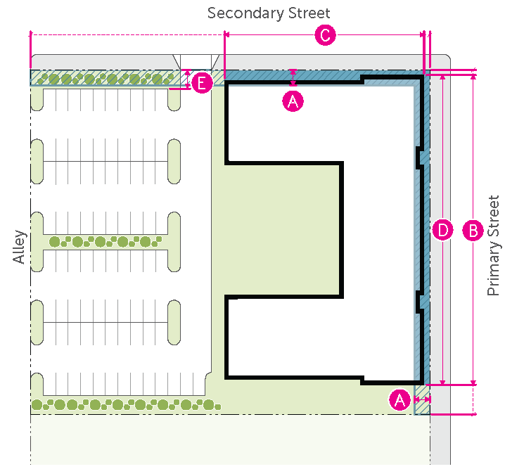
| BUILDING | ||
| Build-to zone (min./max.) | 0'/5' | |
| Build-to width: primary street (min.) | 90% | |
| Build-to width: secondary street (min.) | 70% | |
| Building width (max.) | 325' | |
| PARKING | ||
| Parking between building and street | Prohibited | |
| Parking setback from street (min.) | 15' | |
| Interior parking lot landscaping | n/a | |
| Parking lot perimeter screening | n/a | |
2.
Vertical Scale
(See 20.25.080.C.4.)
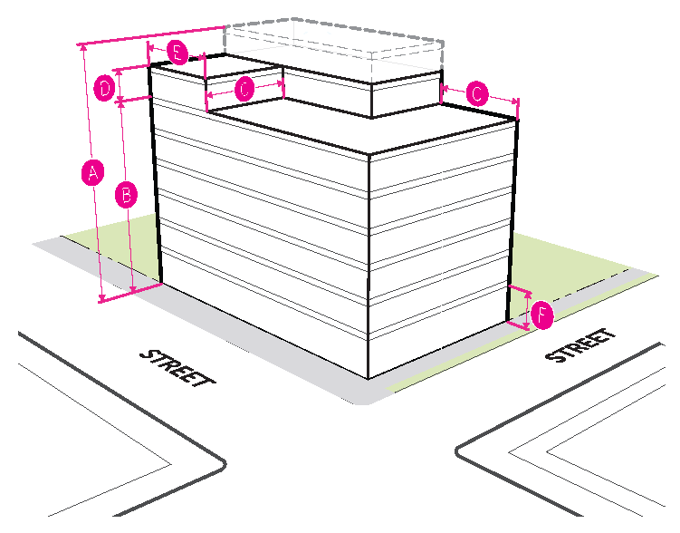
| BUILDING HEIGHT | ||
| Building height (max.) | See underlying zoning | |
| UPPER STORY STEPBACK | ||
| Street wall height (max.) |
85'
6 stories | |
| Stepback depth (min.) | 10' | |
| Stepback exception: height (max.) |
15'
1 story | |
| Stepback exception: width (max.) | 30% | |
| FLOOR TO CEILING HEIGHT | ||
| Residential (min.) | 10' | |
| Non-residential (min.) | 13' | |
3.
Facade Design
(See 20.25.080.C.5.)
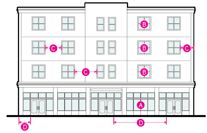
| Primary Street | Secondary Street | ||
| GROUND FLOOR | |||
| Glazed area: commercial (min.) | 65% | 50% | |
| Glazed area: residential (min.) | 65% | 50% | |
| UPPER FLOOR | |||
| Glazed area (min.) | 20% | 20% | |
| Blank wall width (max.) | 8' | 8' | |
| ENTRANCES | |||
| Street-facing entrance | Required | n/a | |
| Distance between entries (max.) | 50' | 50' | |
C.
Downtown Outer Core
The Downtown Outer Core is an essential part of the urban center and should be experienced
as part of it. It contains many historic resources that provide a reference for design,
but the area is more diverse in building types than the Downtown Inner Core. Nonetheless,
most buildings contribute to an urban street experience, with facades located at the street edge
and activated with storefronts. New designs in the Downtown Outer Core should contribute
to this engaging street experience.
1.
Site Design
(See 20.25.080.C.3.)
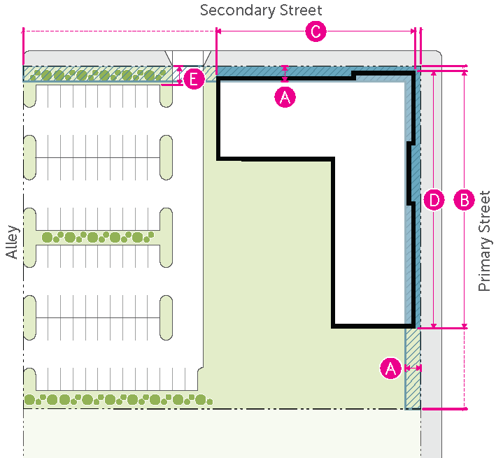
| BUILDING | ||
| Build-to zone (min./max.) | 0'/5' | |
| Build-to width: primary street (min.) | 80% | |
| Build-to width: secondary street (min.) | 60% | |
| Building width (max.) | 275' | |
| PARKING | ||
| Parking between building and street | Prohibited | |
| Parking setback from street (min.) | 15' | |
| Interior parking lot landscaping | n/a | |
| Parking lot perimeter screening | n/a | |
2.
Vertical Scale
(See 20.25.080.C.4.)
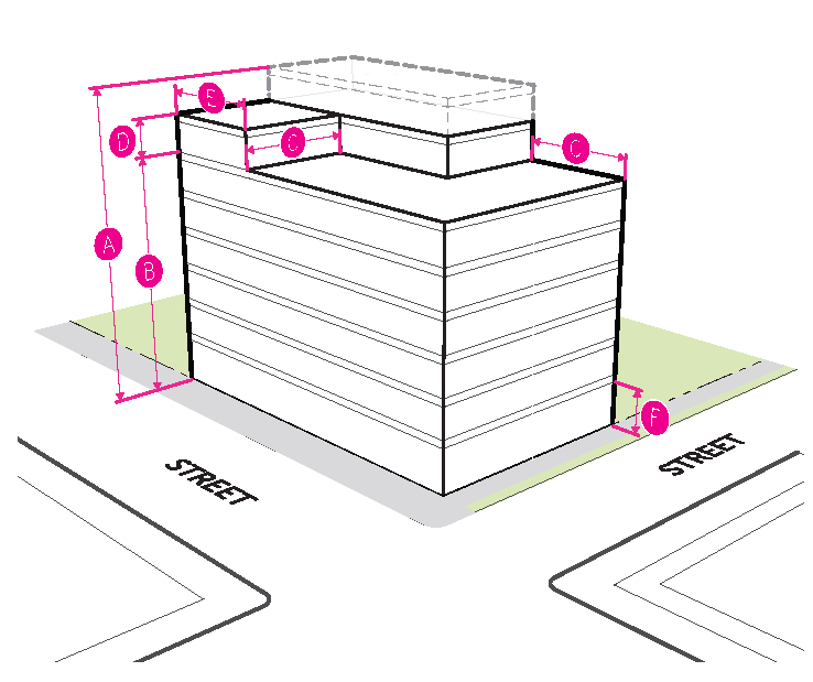
| BUILDING HEIGHT | ||
| Building height (max.) | See underlying zoning | |
| UPPER STORY STEPBACK | ||
| Street wall height (max.) |
85'
6 stories | |
| Stepback depth (min.) | 10' | |
| Stepback exception: height (max.) |
15'
1 story | |
| Stepback exception: width (max.) | 30% | |
| FLOOR TO CEILING HEIGHT | ||
| Residential (min.) | 10' | |
| Non-residential (min.) | 13' | |
3.
Facade Design
(See 20.25.080.C.5.)
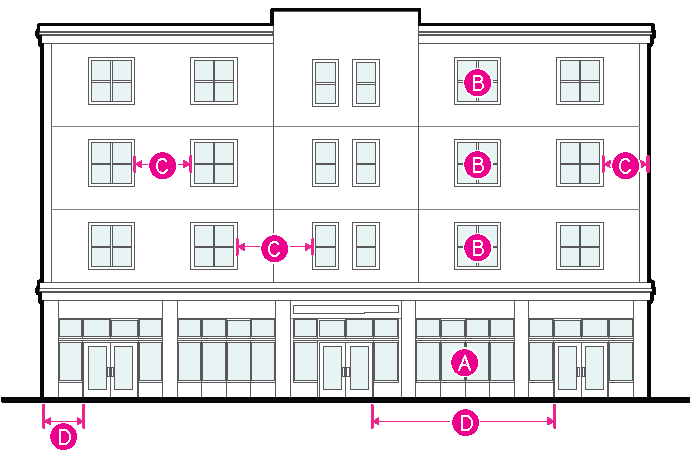
| Primary Street | Secondary Street | ||
| GROUND FLOOR | |||
| Glazed area:
commercial (min.) | 65% | 40% | |
| Glazed area:
residential (min.) | 30% | 30% | |
| UPPER FLOOR | |||
| Glazed area (min.) | 20% | 20% | |
| Blank wall width (max.) | 10' | 10' | |
| ENTRANCES | |||
| Street-facing entrance | Required | n/a | |
| Distance between entries: Non-residential (max.) | 70' | 70' | |
| Distance between entries: Residential (max.) | 100' | 100' | |
D.
Downtown Hip Strip
The Downtown Hip Strip is a distinctively unique part of Downtown, with a mix of older
and newer buildings of a moderate scale. It has a diverse range of building types that are interesting
at the street level, and generally built close to the street edge in ways that invite
exploration. Public art and creative signs, colors and artistic elements are encouraged.
1.
Site Design
(See 20.25.080.C.3.)
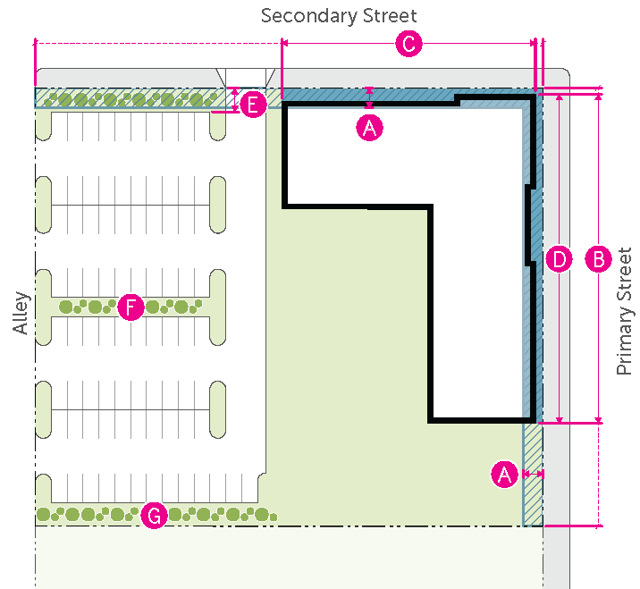
| BUILDING | ||
| Build-to zone (min./max.) | 0'/5' | |
| Build-to width: primary street (min.) | 70% | |
| Build-to width: secondary street (min.) | 40% | |
| Building width (max.) | 275' | |
| PARKING | ||
| Parking between building and street | Prohibited | |
| Parking setback from street (min.) | 15' | |
| Interior parking lot landscaping | Required | |
| Parking lot perimeter screening | Required | |
2.
Vertical Scale
(See 20.25.080.C.4.)
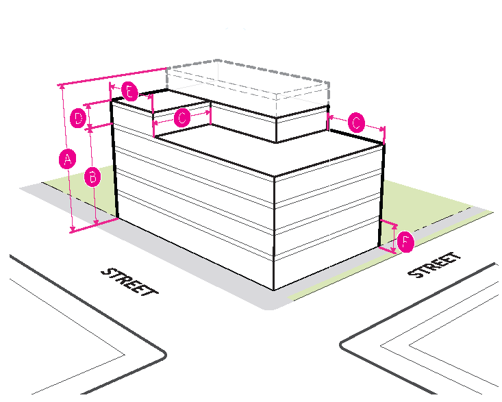
| BUILDING HEIGHT | ||
| Building height (max.) | See underlying zoning | |
| UPPER STORY STEPBACK | ||
| Street wall height (max.) |
60'
4 stories | |
| Stepback depth (min.) | 10' | |
| Stepback exception: height (max.) |
15'
1 story | |
| Stepback exception: width (max.) | 30% | |
| FLOOR TO CEILING HEIGHT | ||
| Residential (min.) | 10' | |
| Non-residential (min.) | 13' | |
3.
Facade Design
(See 20.25.080.C.5.)
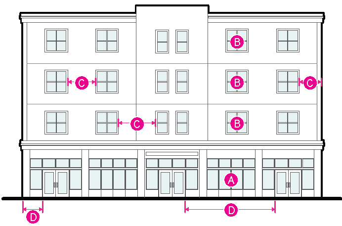
| Primary Street | Secondary Street | ||
| GROUND FLOOR | |||
| Glazed area:
commercial (min.) | 65% | 40% | |
| Glazed area:
residential (min.) | 30% | 30% | |
| UPPER FLOOR | |||
| Glazed area (min.) | 20% | 20% | |
| Blank wall width (max.) | 10' | 10' | |
| ENTRANCES | |||
| Street-facing entrance | Required | n/a | |
| Distance between entries: Non-residential (max.) | 70' | 70' | |
| Distance between entries: Residential (max.) | 100' | 100' | |
E.
Downtown Gateway
Gateway areas frame Downtown and contribute to a sense of entry into the urban center.
These areas are in transition, evolving from an auto-oriented character to a more
urban experience. They will include commercial and residential developments with a variety of building forms and street edge characteristics. New development should establish a more urban feel. Downtown Gateways often have edges that face
established residential neighborhoods, and compatible transitions in these locations
are important.
1.
Site Design
(See 20.25.080.C.3.)
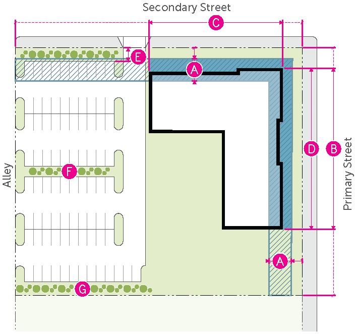
| BUILDING | ||
| Build-to zone (min./max.) | 5'/15' | |
| Build-to width: primary street (min.) | 60% | |
| Build-to width: secondary street (min.) | 30% | |
| Building width (max.) | 325' | |
| PARKING | ||
| Parking between building and primary street | Prohibited | |
| Parking between building and secondary street | Limited | |
| Parking setback from street (min.) | 10' | |
| Interior parking lot landscaping | Required | |
| Parking lot perimeter screening | Required | |
2.
Vertical Scale
(See 20.25.080.C.4.)
| BUILDING HEIGHT | ||
| Building height (max.) | See underlying zoning | |
| UPPER STORY STEPBACK | ||
| Street wall height (max.) |
60'
4 stories | |
| Stepback depth (min.) | 15' | |
| Stepback exception: height (max.) |
15'
1 story | |
| Stepback exception: width (max.) | 30% | |
| FLOOR TO CEILING HEIGHT | ||
| Residential (min.) | 10' | |
| Non-residential (min.) | 13' | |
3.
Facade Design
(See 20.25.080.C.5.)
| Primary Street | Secondary Street | ||
| GROUND FLOOR | |||
| Glazed area:
commercial (min.) | 60% | 40% | |
| Glazed area:
residential (min.) | 30% | 30% | |
| UPPER FLOOR | |||
| Glazed area (min.) | 20% | 20% | |
| Blank wall width (max.) | 12' | 12' | |
| ENTRANCES | |||
| Street-facing entrance | Required | n/a | |
| Distance between entries: Non-residential (max.) | 90' | 90' | |
| Distance between entries: Residential (max.) | 120' | 120' | |
F.
Downtown North
The Downtown North Context will continue to be home to a variety of building types
and forms. It will serve as a transition between the Downtown Gateway Area around
Broadway and the residential neighborhood to the north, with moderately scaled buildings. While increases in density and scale are desired, buildings and sites should be designed to fit in with the residential character.
1.
Site Design
(See 20.25.080.C.3.)
| BUILDING | ||
| Build-to zone (min./max.) | 10'/20' | |
| Build-to width: primary street (min.) | 60% | |
| Build-to width: secondary street (min.) | 30% | |
| Building width (max.) | 160' | |
| PARKING | ||
| Parking between building and primary street | Prohibited | |
| Parking between building and secondary street | Limited | |
| Parking setback from street (min.) | 10' | |
| Interior landscaping | Required | |
| Parking lot perimeter screening | Required | |
2.
Vertical Scale
(See 20.25.080.C.4.)
| BUILDING HEIGHT | ||
| Building height (max.) | See underlying zoning | |
| UPPER STORY STEPBACK | ||
| Street wall height (max.) |
45'
3 stories | |
| Stepback depth (min.) | 20' | |
| FLOOR TO CEILING HEIGHT | ||
| Residential (min.) | 10' | |
| Non-residential (min.) | 13' | |
3.
Facade Design
(See 20.25.080.C.5.)
| Primary Street | Secondary Street | ||
| GROUND FLOOR | |||
| Glazed area:
commercial (min.) | 45% | 30% | |
| Glazed area:
residential (min.) | 20% | 20% | |
| UPPER FLOOR | |||
| Glazed area (min.) | 20% | 20% | |
| Blank wall width (max.) | 12' | 12' | |
| ENTRANCES | |||
| Street-facing entrance | Required | n/a | |
| Distance between entries: Non-residential (max.) | 90' | 90' | |
| Distance between entries: Residential (max.) | 120' | 120' | |
(Ord. 3769, 2025; Ord. 3733, 2024; Ord. 3723, 2023; Ord. 3624, 2018)
20.25.082 - /DE-C, Design Excellence - Corridor Overlay
Click here to view a PDF of Section 20.25.082.
A.
General
1.
The design standards in this Section apply to development within the /DE-C Design Excellence - Corridor Overlay. The City maintains a map of specific parcels subject to each of the subdistricts in this Section.
2.
Additional general design standards that apply to all Design Excellence Overlay subdistricts are included in 20.25.080.C.2. This Section also contains definitions, rules for measurement, and guidance for interpretation of these standards.
3.
These Design Excellence - Corridor Standards apply to projects that require Zoning Compliance Review (see 20.25.080.B.1.b.) as well as those that require Design Excellence Review (see 20.25.080.B.1.a.).
4.
Those portions of the various Corridors that are designated as Nodes in Corridor Typologies 2, 3 and 4 are required to meet the Site Design standards and Floor to Ceiling Height for Typology 1 (20.25.082.B.).
B.
Corridor Typology 1
Typology 1 Corridors have been identified to be redeveloped as mixed-use, pedestrian-oriented
streets that support transit and prioritize placemaking. Walkability in these areas
should be heavily emphasized. Mid-rise development is encouraged. Buildings are located to tightly frame the street with a consistent street wall, but some minor
fluctuation in front setback is encouraged. Parking should be shared among multiple buildings wherever possible. High levels of transparency and detailing are promoted at the
street level.
1.
Site Design
(See 20.25.080.C.3.)
| BUILDING | ||
| Build-to zone (min./max.) | 5'/10' | |
| Build-to width: primary street (min.) | 75% | |
| Build-to width: secondary street (min.) | 55% | |
| Building width (max.) | 300' | |
| PARKING | ||
| Parking between building and street | Prohibited | |
| Parking setback from street (min.) | 15' | |
| Interior landscaping | Required | |
| Parking lot perimeter screening | Required | |
2.
Vertical Scale
(See 20.25.080.C.4.)
| BUILDING HEIGHT | ||
| Building height (max.) | See underlying zoning | |
| UPPER STORY STEPBACK | ||
| Street wall height (max.) |
85'
6 stories | |
| Stepback depth (min.) | 15' | |
| Stepback exception: height (max.) |
15'
1 story | |
| Stepback exception: width (max.) | 30% | |
| FLOOR TO CEILING HEIGHT | ||
| Residential (min.) | 10' | |
| Non-residential (min.) | 13' | |
3.
Facade Design
(See 20.25.080.C.5.)
| Primary Street | Secondary Street | ||
| GROUND FLOOR | |||
| Glazed area:
commercial (min.) | 60% | 40% | |
| Glazed area:
residential (min.) | 30% | 30% | |
| UPPER FLOOR | |||
| Glazed area (min.) | 20% | 20% | |
| Blank wall width (max.) | 8' | 12' | |
| ENTRANCES | |||
| Street-facing entrance | Required | n/a | |
| Distance between entries: (max.) | 60' | 60' | |
4.
Articulation
C.
Corridor Typology 2
Typology 2 Corridors are closely knitted with the residential neighborhoods that surround
them. Where residentially-zoned properties front a Corridor, adjacent commercial development should be designed to respond sensitively to them; designed with smaller scale elements
and lower scale at the street edge to help them fit in. The visual impact of parking
should be minimized to provide a highly walkable street edge. Buildings are oriented to the street, but building placement flexibility is promoted. Sets
of buildings that cluster around courtyards or other amenities are encouraged.
1.
Site Design
| BUILDING | ||
| Build-to zone (min./max.) | 5'/15' | |
| Build-to width: primary street (min.) | 50% | |
| Build-to width: secondary street (min.) | 45% | |
| Building width (max.) | 175' | |
| PARKING | ||
| Parking between building and street | Prohibited | |
| Parking setback from street (min.) | 10' | |
| Interior landscaping | Required | |
| Parking lot perimeter screening | Required | |
2.
Vertical Scale
(See 20.25.080.C.4.)
| BUILDING HEIGHT | ||
| Building height (max.) | See underlying zoning | |
| UPPER STORY STEPBACK | ||
| Street wall height (max.) |
45'
3 stories | |
| Stepback depth (min.) | 15' | |
|
Stepback exception:
height (max.) |
15'
1 story | |
|
Stepback exception:
width (max.) | 30% | |
| FLOOR TO CEILING HEIGHT | ||
| Residential (min.) | 10' | |
| Non-residential (min.) | 10' | |
3.
Facade Design
(See 20.25.080.C.5.)
| Primary Street | Secondary Street | ||
| GROUND FLOOR | |||
| Glazed area:
commercial (min.) | 50% | 35% | |
| Glazed area:
residential (min.) | 30% | 30% | |
| UPPER FLOOR | |||
| Glazed area (min.) | 20% | 20% | |
| Blank wall width (max.) | 12' | 16' | |
| ENTRANCES | |||
| Street-facing entrance | Required | n/a | |
|
Distance between entries:
Non-residential (max.) | 80' | 80' | |
|
Distance between entries:
Residential (max.) | 100' | 100' | |
4.
Articulation
D.
Corridor Typology 3
Typology 3 Corridors should be designed to promote an enhanced entry experience for
those coming into the City or Downtown, and establish a strong emphasis on walkability
and visual interest. Development along Typology 3 Corridors should provide a moderately-strong building presence along
the street to frame the roadway and pedestrian space. Parking adjacent to the street
should be limited, with the majority of surface parking located to the side or rear
of a building.
1.
Site Design
(See 20.25.080.C.3.)
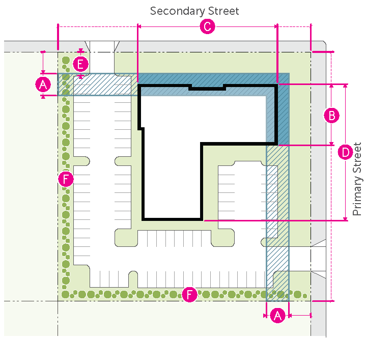
| BUILDING | ||
| Build-to zone (min./max.) | 10'/20' | |
| Build-to width: primary street (min.) | 40% | |
| Build-to width: secondary street (min.) | 35% | |
| Building width (max.) | 300' | |
| PARKING | ||
| Parking between building and street | Limited | |
| Parking setback from street (min.) | 10' | |
| Interior landscaping | Required | |
| Parking lot perimeter screening | Required | |
2.
Vertical Scale
(See 20.25.080.C.4.)
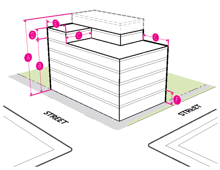
| BUILDING HEIGHT | ||
| Building height (max.) | See underlying zoning | |
| UPPER STORY STEPBACK | ||
| Street wall height (max.) |
70'
5 stories | |
| Stepback depth (min.) | 20' | |
| Stepback exception: height (max.) |
15'
1 story | |
| Stepback exception: width (max.) | 30% | |
| FLOOR TO CEILING HEIGHT | ||
| Residential (min.) | 10' | |
| Non-residential (min.) | 10' | |
3.
Facade Design
(See 20.25.080.C.5.)
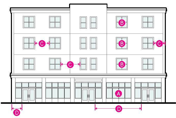
| Primary Street | Secondary Street | ||
| GROUND FLOOR | |||
| Glazed area:
commercial (min.) | 50% | 35% | |
| Glazed area:
residential (min.) | 30% | 30% | |
| UPPER FLOOR | |||
| Glazed area (min.) | 20% | 20% | |
| Blank wall width (max.) | 14' | 14' | |
| ENTRANCES | |||
| Street-facing entrance | Required | n/a | |
|
Distance between entries:
Non-residential (max.) | 120' | 120' | |
|
Distance between entries:
Residential (max.) | 150' | 150' | |
4.
Articulation
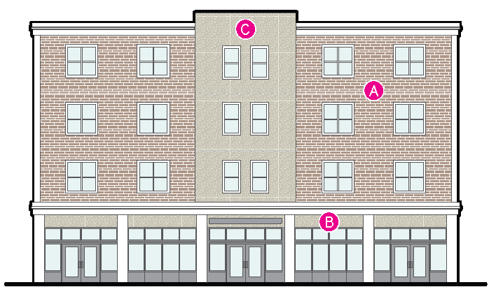
E.
Corridor Typology 4
Typology 4 Corridors continue to facilitate larger-format commercial development that caters to the needs of drivers, but provide an attractive edge environment that
softens the visual impact of parking and buffers the pedestrian. Flexibility in parking
siting and variety in building placement relative to the street is supported. Development should not be a barrier to connectivity, and opportunities to enhance pedestrian
and multi-modal mobility should be promoted.
1.
Site Design
(See 20.25.080.C.3.)
| BUILDING | ||
| Street setback: primary street (min.) | 15' * | |
| Street setback: secondary street (min.) | 10' | |
| Build-to zone (min./max.) | n/a | |
| Build-to width | n/a | |
| Building width (max.) | 600' | |
| PARKING | ||
| Parking between building and street | Allowed | |
| Parking setback from street (min.) | 10' | |
| Interior parking lot landscaping | Required | |
| Parking lot perimeter screening | Required | |
| * See 20.25.082.E.5 for special setback. | ||
2.
Vertical Scale
(See 20.25.080.C.4.)
| BUILDING HEIGHT | ||
| Building height (max.) | See underlying zoning | |
| UPPER STORY STEPBACK | ||
| Street wall height (max.) |
60'
4 stories | |
| Stepback depth (min.) | 15' | |
|
Stepback exception:
height (max.) |
15'
1 story | |
|
Stepback exception:
width (max.) | 30% | |
| FLOOR TO CEILING HEIGHT | ||
| Residential (min.) | 10' | |
| Non-residential (min.) | 10' | |
3.
Facade Design
(See 20.25.080.C.5.)

| Primary Street | Secondary Street | ||
| GROUND FLOOR | |||
| Glazed area:
commercial (min.) | 35% | 25% | |
| Glazed area:
residential (min.) | 20% | 20% | |
| UPPER FLOOR | |||
| Glazed area (min.) | 20% | 20% | |
| Blank wall width (max.) | 16' | 16' | |
| ENTRANCES | |||
| Street-facing entrance | Visible from the Corridor | n/a | |
| Distance between entries: (max.) | 160' | 160' | |
4.
Articulation
5.
Special Setback
In Corridor Typology 4, due to irregular right-of-way, the setback along the west side of Reserve Street generally from Mount Street and South 5th Street
West, as more specifically depicted on the map below, will be measured from the back
edge of a 30-foot "no build" line that begins at the back of the existing curb and
approximates the right-of-way line for the blocks to the north and south of the designated
area.
(Ord. 3769, 2025; Ord. 3733, 2024; Ord. 3723, 2023; Ord. 3624, 2018)
Note— Interim provisions of Ord. 3769 expire March 24, 2026.
20.25.090 - /TO, Transit-Oriented Overlay
Reserved
(Ord. 3439, 2010; Ord. 3410, 2009)