
Missoula City Zoning Code
CHAPTER 20
50 - Natural Resource Protection
20.50.010 - Hillside Protection
A.
Purpose
1.
Missoula's hillsides are characterized by slope, vegetation, drainage, rock outcroppings, geologic hazards, and other physical factors that, if disturbed for the purposes of development, can cause physical damage to public and private property and adversely affect the overall appearance and character of the city.
2.
The hillside protection regulations of this section are intended to regulate building and development on hillsides in a different manner than on flat terrain. The regulations are intended to allow reasonable use of hillside areas, while also helping to:
a.
Protect the public from natural hazards due to seismic activity, landslides, slope and soil instability, erosion and sedimentation, and stormwater runoff;
b.
Preserve and retain wildlife habitat, open space and natural features, such as drainage channels, streams, ridge lines, rock outcroppings, vistas, and native trees and vegetation;
c.
Promote design that is sensitive to existing vistas;
d.
Preserve and enhance visual and environmental quality by use of natural vegetation and minimal excavation and terracing;
e.
Encourage innovative planning, design, and construction techniques for development in environmentally sensitive areas; and
f.
Mitigate adverse impacts, including erosion and the degradation of air and water quality.
B.
Applicability
1.
The hillside protection standards of this section apply to any parcel with natural, existing or finished slopes of 15% or greater except for the following development options:
a.
Development proposing a single unit on an R zoned parcel shall determine applicability based on building and disturbance area and will be subject to sections 20.50.010.E—L and review shall be limited to the building and disturbance area.
b.
Development proposed on parcels created prior to March 22, 1999 (adoption of Hillside Design Standards) with natural or existing slopes of 15% or greater shall be subject to sections 20.50.010.G—L and review shall be limited to the building and disturbance area, except for the following development option:
(1)
Where the building and disturbance area is located on a portion of the parcel where the existing or natural slope is less than 15% are not subject to the Hillside Protection Standards in Section 20.50.010.
Commentary: Providing information depicting the average slope of a parcel is not required unless the planning office has a question regarding the applicability of Section 20.50.010, Hillside Protection.
2.
The average (percent) slope (S) of a building and disturbance area is determined as follows:
a.
Identify the building and disturbance area and depict it on a topographic map of existing terrain, before any grading or other site modification has occurred, at a scale of no less than one inch equals 100 feet with contour intervals of two feet or less.
b.
A measurement of the length of each contour line contained with the building and disturbance area boundaries is made.
c.
The sum of the lengths of all contour lines (L) is multiplied by the contour interval (I) in feet.
d.
The result is multiplied by a factor of 0.0023 (which converts square feet to acres and multiplies the result by 100 so that the end result is a percentage).
e.
The result is then divided by the area (A) of the building and disturbance area in acres.
f.
This process is mathematically represented by the following formula:
S = (I) (L) (0.0023)
A
g.
A digital slope analysis that ensures the same or higher level of accuracy may also be used.
C.
Hillside Development Site Analysis
1.
Before the zoning officer may approve a zoning compliance permit, the applicant must submit a hillside development site analysis that assesses the subject parcel's opportunities and constraints for development. The analysis must be prepared by a qualified professional (e.g., engineer, landscape architect, architect or engineer) and depict and identify at least the following information:
a.
A slope analysis, submitted on a topographic map with contour intervals of two feet or less indicating the location and amount of land greater than 25%. If the project is subject to section 20.50.010.D (Allowed Density by Slope Category) all categories shown below must be represented:
(1)
15% or less;
(2)
15.01—20%;
(3)
20.01—25%; or
(4)
Greater than 25%.
b.
Proposed finish contours (after all proposed grading);
c.
Protected ridgelines, as shown on the City of Missoula Ridgeline Map;
d.
Proposed erosion control and slope stabilization techniques;
e.
Surface hydrological conditions including natural drainage courses, streams, floodplains, wetlands and ponding areas;
f.
Location and types of significant vegetation including known rare and endangered plant species and general plant communities;
g.
Habitat areas for rare or endangered animal species;
h.
Proposed building and disturbance area;
i.
Grading treatments; and
j.
Driveways and other vehicular and pedestrian circulation routes.
2.
A hillside development site analysis is not required for any of the following:
a.
Construction that does not require a grading permit or a building permit.
b.
The construction and installation (trenching, utility construction and backfilling) of underground utility systems.
c.
Additions to existing structures and/or construction of accessory structures that are less than 500 square feet in area, unless a grading permit or plan for such improvements is required.
d.
Any project that has received a zoning compliance permit.
D.
Allowed Densityby Average Slope
1.
The following maximum density limits (expressed as minimum area-per-unit requirements) apply:
E.
Minimum Pad Size and Maximum Buildable Slope
Parcels must have at least a 2,000 square foot contiguous building and disturbance area with an average slope of no more than 25%. See 20.50.010.B.1 for average slope determination. Building
and disturbance is prohibited on slopes of greater than 25% outside the minimum contiguous building and disturbance area.
F.
Grading
No excavation or other earth disturbance is permitted on any hillside area prior to
the issuance of a grading permit, with the exception of drill holes and exploratory
trenches for the collection of geologic and soil data. Such trenches must be properly
backfilled and erosion treatment must be provided where such slopes exceed 20%.
G.
Retaining Walls
Retaining walls can help reduce the steepness of man-made slopes and provide planting pockets conducive to re-vegetation. They are allowed in accordance
with the following regulations:
1.
Retaining walls may be used to support steep slopes but may not exceed six feet in height from finished grade. Retaining walls necessary to accommodate vehicle or pedestrian access to a building may be up to eight feet in height from finished grade. Retaining walls are prohibited in public right-of-way except as approved by the city engineer.
Commentary: Retaining walls exceeding four feet in height require a building permit and must be designed by a qualified engineer.
2.
Terracing of retaining walls is limited to two tiers. The width of the terrace between four-foot vertical retaining walls must be at least three feet. Retaining walls with a height of more than four feet must be separated from any other retaining wall by a minimum distance of five feet (horizontal distance). Terraces created between retaining walls must be permanently landscaped or revegetated.
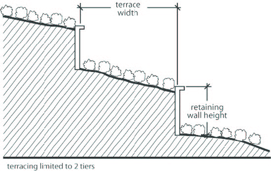
Figure 20.50-1 Natural Resource Protection, Hillside Protection, Retaining Walls
H.
Driveways
1.
Driveway standards are administered and enforced by the city engineering division.
2.
Driveways must be designed to:
a.
Reduce cut and fill;
b.
Minimize site disturbance;
c.
Provide year-round access; and
d.
Accommodate emergency response equipment.
3.
Driveways must substantially follow natural contours and not exceed a maximum grade of eight percent. A maximum grade of up to ten percent may be allowed for a length of up to 50 feet if approved by the Fire Department and city engineer.
I.
Building Height Envelope
Buildings in areas subject to the hillside protection standards of this section are not subject
to the building height measurement provisions of 20.110.060.A but instead are subject
to the following building height "envelope" measurement provisions:
1.
The bottom portion of the building height envelope is referred to as the "ground plane," which is a plane that follows existing grade beneath the building and all projections of the building's roof (roof overhang).
2.
The upper portion of the building height envelope is an imaginary plane that parallels the ground plane described in 20.50.010.I.1 and is located above the ground plane a vertical distance equal to the maximum height limit of the subject zoning district.
3.
All portions of the building must fit within this building height envelope, excluding those building height exceptions allowed by 20.110.060.B.
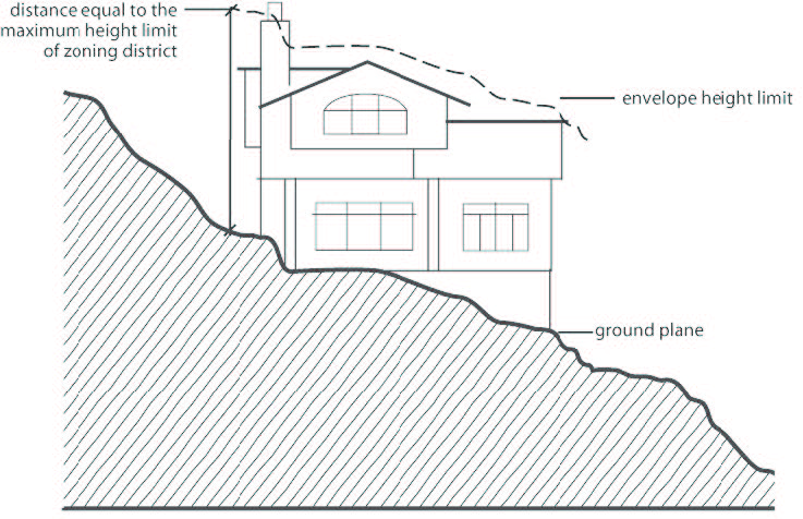
Figure 20.50-2 Natural Resource Protection, Hillside Protection, Building Height Envelope
J.
Exposed Foundations
The vertical distance between the lowest point where the building line meets existing or finished grade (whichever is lower) and the lowest floor line of the building may not exceed eight feet in height.
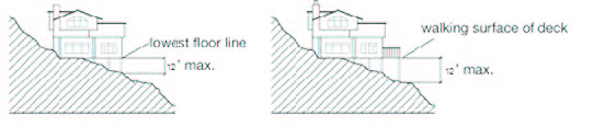
Figure 20.50-3 Natural Resource Protection, Hillside Protection, Exposed Foundations
and Visible Deck Supports
K.
Visible Deck Supports
No portion of the walking surface of a deck or porch with visible columns, posts,
piers may exceed a height of 12 feet above finished grade measured from the furthest projecting point of the deck or porch.
L.
Building Wall Elements
1.
A building wall element is any individual wall or continuous element of a building on a single continuous plane. Wall elements adjacent to grade must be measured from the lowest existing grade to the underside of the eave or top of coping of a flat roof. Wall elements not adjacent to grade must be measured from the lowest point at which the wall element intersects any part of the adjacent building element to the underside of the eave or top of coping of a flat roof. A gable end above the eave is excluded from the wall element measurement.
2.
Building wall elements may not exceed 22 feet in height (vertically). Individual wall elements may be stacked vertically only if the total cumulative vertical dimension of all stacked wall elements does not exceed 22 feet in height or if the wall elements are offset by at least 12 feet in horizontal distance. Wall elements will be considered offset for the purpose of these hillside protection regulations only if: (1) they are separated by at least 12 feet in horizontal distance; and (2) the offset occurs by stepping the building back towards the slope (uphill).
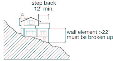
Figure 20.50-4 Natural Resource Protection, Hillside Protection, Building Wall Elements
(Ord. 3735, 2024; Ord. 3669, 2020; Ord. 3471, 2011; Ord. 3439, 2010; Ord. 3410, 2009)
20.50.020 - Ridgeline Protection
A.
Applicability
The ridgeline protection regulations of this section apply to any parcel containing protected ridge areas, as shown on the City of Missoula Ridgeline Map,
which is available in Development Services.
B.
Purpose
The ridgeline protection standards of this section are intended to help ensure that
structures blend more naturally into the landscape rather than being a prominent focal point.
C.
Ridgeline Map
Reserved
D.
Ridgeline Setbacks
On parcels subject to the ridgeline protection regulations of this section, the highest point
of a proposed building must be at least 90 feet below the ridgeline elevation. Building features allowed
to exceed maximum height requirements are exempt from this requirement. (See 20.110.060.B
for building height exceptions.)
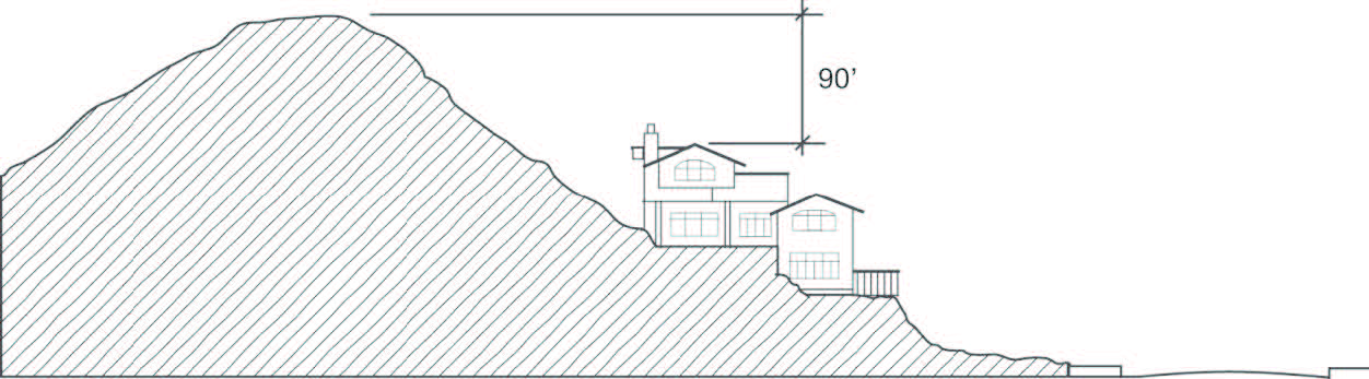
Figure 20.50-5 Ridgeline Protection, Ridgeline Setbacks
(Ord. 3439, 2010; Ord. 3410, 2009)
20.50.030 - Riparian Resource Protection
A.
Purpose
1.
Riparian resources provide protection from river channel changes, protection of riparian habitat and associated fish and wildlife, protection of water quality and quantity, flood reduction, bio-diversity, forage, recreational uses and a visually attractive environment. Educational opportunities in Missoula's areas of riparian resource may lead to a greater understanding, and thus, greater protection and enhancement of these valuable resources.
2.
The riparian resource protection regulations of this section are intended to trigger inquiries when construction is proposed in or through what may be considered an area of riparian resource. A functional definition and standards for an area of riparian resource will protect the area of riparian resource, which will vary in width. Areas of riparian resource represent a very small percentage of the land area of the City of Missoula. A map generally locating major areas of riparian resource protection is available for public inspection in Development Services. Not all areas of riparian resource within the City of Missoula are shown on this map. Areas of riparian resource are typed by site-specific soil, habitat and community types. All other unmapped riparian resources that meet the definitions and criteria contained in this ordinance are subject to the standards of this section.
B.
Areas of Riparian Resource, Generally
The riparian resource protection regulations of this section are intended to promote
resource conservation and to ensure that no development is approved that is unsuitable by reason of flooding, inadequate drainage, soil and
rock formations with severe limitations for development, severe erosion potential, unfavorable topography, damaging to areas of riparian resource or any other feature likely to be harmful to the public health, safety and welfare
of the future residents of the city. More specifically, it is the intent of these
regulations to ensure that:
1.
Areas of riparian resource remain available to support diverse and productive aquatic and terrestrial riparian systems and habitats and to protect water quality;
2.
Stream channels and banks are protected;
3.
Areas of riparian resource are preserved to act as an effective sediment filter to maintain water quality;
4.
Areas of riparian resource are protected to preserve large, woody debris that is eventually recruited into a stream to maintain riffles, pools and other elements of channel structure and provide shade to regulate stream temperature;
5.
Areas of riparian resource are protected to preserve connectivity corridors for wildlife;
6.
Areas of riparian resource are preserved to promote floodplain stability;
7.
The public interest in the quality and quantity of surface and groundwaters is protected;
8.
Standards for land disturbance in riparian resource areas are site-specific, allowing flexibility for reasonable and economically beneficial use of property, while maintaining the integrity of riparian resource areas;
9.
Any allowed disturbance within the riparian buffer area protects and maintains the integrity and function of riparian resource areas; and
10.
The area of riparian resource is preserved to promote the high quality of life in the city, which depends in part on water quality, a healthy and visually attractive natural environment, and ample recreational opportunities.
C.
Riparian Resource Management Plan
In order to meet the purposes described in 20.50.030.B, a riparian resource management
plan must be submitted to the zoning officer for approval, approval with conditions,
or denial. The plan must include at least the following:
1.
A vegetation map showing the following:
a.
Location of vegetation types referred to in 20.50.030.H;
b.
Buffer areas; and
c.
Drainage.
2.
A description of the following:
a.
The vegetation (types and quantities) listed in 20.50.030.H;
b.
Contribution of the type to stream bank stabilization;
c.
Susceptibility of soil to compaction;
d.
Contribution of the vegetation in preventing erosion; and
e.
Contribution of the vegetation to fish and wildlife habitat, including big game species, upland game bird species, non-game bird species, fisheries, and threatened or endangered species.
3.
A description of how the area of riparian resource will be maintained, restored or enhanced. The description must include at least the following information:
a.
Proposed disturbance of the area of riparian resource, including access to or through the area, if proposed;
b.
Alteration, enhancement and restoration plan including planned restoration of the area with native species;
c.
Planned mitigation of impacts from all proposed disturbance;
d.
Planting plan; and
e.
Streambank stabilization plan.
4.
A maintenance and monitoring plan outlining how the area of riparian resource will be cared for after occupancy. The approved management plan must be carried out and enforced. It may not be altered without express approval of the director of Development Services.
D.
Development Prohibition
1.
Except as provided in 20.50.030.F no development is allowed within an area of riparian resource. Development proposed for sites that encompass portions of areas of riparian resource must provide for protection of the resource specific to the area.
2.
Proposed development on sites that encompass areas of riparian resource must place development outside the area of riparian resource. No improvements of any kind may be approved that are within the area of riparian resource, except for those improvements that are outlined in the approved management plan. The area of riparian resource may be counted in calculating allowed density and intensity of development andin meeting open space requirements in cluster and conservation development.
E.
Road Constructionin Areas of Riparian Resource
Road construction is prohibited in an area of riparian resource.
F.
TrailConstructionin Areas of Riparian Resource
Trails can be shared or classified for specific use. Trails may provide opportunities for recreational, educational, aesthetic, experiential
and transportation purposes. Trails have long-term beneficial impact upon livability, such as improved air quality, less
traffic congestion and access to open spaces. Trail designs should reflect the character of the surrounding area. Various methods may
be used to provide buffering, including trail location and physical buffers such as plants, distance, grade separation or other
means. If trails are constructed, the following requirements apply:
1.
Opportunities for public or private access must be consolidated to protect areas of riparian resource from excessive disturbance.
2.
Trails must be limited to the size and extent necessary to maintain linkages and provide for safe, non-motorized transportation, as described in the Missoula Non-Motorized Transportation Plan.
3.
The function of the proposed trail, the level of use, the potential impacts and the management strategy to mitigate any adverse effects on the area of riparian resource must be defined.
4.
To serve safety and security, construction, landscaping, and signage must clearly define the trail and mark the transition from public to private space.
5.
A mechanism must be provided assuring continued maintenance of the trail, including keeping the trail weed-free.
6.
Removal or disturbance of riparian resources must be minimized. To the greatest extent possible, existing landforms must be preserved, including following natural contours and minimizing grading.
7.
No motorized vehicle is allowed within the area of riparian resource, except as necessary for maintenance, agricultural management or safety.
G.
Variances
1.
The Board of Adjustment may grant variances from the requirements of this section if it determines that strict compliance will result in unnecessary hardship and when compliance with the regulations is not essential to the public welfare. The Board of Adjustment must also consider the statements of purpose in 20.50.030.B in determining whether the criteria to grant a variance have been met.
2.
Variances to permit road construction may be approved only if the Board of Adjustment finds that: (1) all of the variance approval criteria of 20.85.090.G have been met; (2) the proposed road is for the purpose of crossing a stream, gaining limited access to a body of water, or maintaining existing roads for flood control; and (3) the proposed road is outlined in the required riparian resource management plan. If roads are allowed to be constructed, the following requirements apply:
a.
The intentional sidecasting of road material into a stream, wetland, or other body of water during road construction or maintenance is prohibited.
b.
Effective erosion and sedimentation control practices must be conducted during all clearing, construction or reconstruction operations.
c.
Road fill material may not be deposited in the area of riparian resource or in a location or manner such that adverse impacts will result to the area.
d.
Roads must be located on the fringes of areas of riparian resource, rather than through them. In the event it is necessary to route a road through an area of riparian resource, then routes must be chosen based on the avoidance of negative impact to sensitive environmental conditions.
e.
Roads may not be constructed in areas where soils have a high susceptibility to erosion that would create sedimentation and pollution problems during and after construction.
f.
Roads may not intrude into areas adjacent to open exposures of water, and they must avoid scenic intrusion by using the existing contours for the road alignment and minimizing the use of fill.
H.
Riparian/Wetland Habitat and Community Types
Appendix A contains a sample listing of riparian/wetland habitat and community types.
(Ord. 3586, 2016; Ord. 3439, 2010; Ord. 3410, 2009)
20.50.040 - Agricultural Land Preservation
Reserved
(Ord. 3439, 2010; Ord. 3410, 2009)
20.50.050 - Wildlife Habitat and Biologically Sensitive Land Protection
Reserved
(Ord. 3439, 2010; Ord. 3410, 2009)
20.50.060 - Wildland Fire Protection
Reserved
(Ord. 3439, 2010; Ord. 3410, 2009)