
Missoula City Zoning Code
CHAPTER 20
100 - Terminology
20.100.010 - General Terms
The words and terms expressly defined in this chapter have the specific meanings assigned, unless the context expressly indicates another meaning. Words that are not expressly defined have the meaning given in the latest edition of Merriam-Webster's Unabridged Dictionary.
Accessory Building
A building that is subordinate in area, extent or purpose to the principal use and
building on the parcel and that is customarily used in conjunction with a permitted
accessory use. (See also the accessory use/structure regulations of Chapter 20.45.)
Accessory Dwelling Unit
A separate dwelling unit within a detached house or a separate dwelling unit that
occupies an accessory building that shares a parcel with a detached house. As the
name implies, accessory dwelling units are an accessory use to the principal use of
the property (i.e., a detached house). (See also the accessory dwelling unit regulations
of 20.45.060.)
Accessory Structure
A structure that is subordinate in area, extent or purpose to the principal use and
building on the parcel and that is customarily used in conjunction with a permitted
accessory use. (See also the accessory use/structure regulations of Chapter 20.45.)
Accessory Use
The use of any land, building or structure that is customarily associated with and
incidental and subordinate to the principal use located on the same parcel (Chapter 20.45).
Administrative Adjustment
Modification of an otherwise applicable standard, approved in accordance with 20.85.110.
Affordable Housing
For the purposes of Title 20, affordable housing means a development that has been approved by the Community Development Division. Community Development
staff and the applicant shall determine the required number of affordable units necessary
to ensure public benefit and financial feasibility of the project.
Agent
A person duly authorized to act on behalf of the subject property owner.
Agricultural Land
Land used for agriculture or having a soil type defined by the Natural Resources Conservation
Service as having agricultural importance, including prime farmland, farmland of state-wide
importance, and farmland of local importance.
Alley
A public right-of-way that affords a means of access to abutting property, generally
secondary in nature.
Antenna
Any equipment or devise used for the purpose of collecting or transmitting electromagnetic
waves, including but not limited to directional antenna such as panels, micro-cells,
small cell antennas, antennas for distributed antenna systems (DAS) microwave dishes,
and satellite dishes, and omni-directional antenna such as whip antenna but not including
satellite earth stations.
Area of Riparian Resource
A stream or other body of water, wet meadow, woody draw, or wetland and land containing
any of the habitat or community types listed in 20.50.030.H, also including the adjacent
buffer area.
Artist Live/Work Space
A dwelling unit in which up to 50% of the floor area is used for the production, showing,
or sale of art.
Attached
Two or more structures are considered attached when they share at least part of a
common wall or are connected by structural elements such as a covered porch, portico
or passageway, the roof of which is an extension of the principal building or designed
to be visually integrated.
Awning
A roof-like structure of rigid material or fabric or similar non-rigid material attached
to a rigid frame that is supported completely or partially by either an exterior building
wall or wall exterior to an individual tenant space.
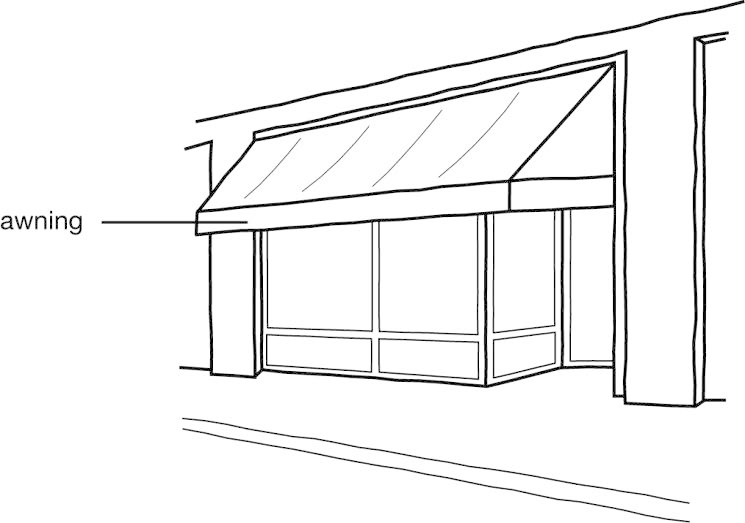
Figure 20.100-1 Terminology, Awning
Base (Zoning) District
Any zoning district that is not an overlay district.
Bay Window
A building projection that: (1) is primarily comprised of a large window or series
of windows; (2) is not supported by a building foundation beneath the window; and
(3) has glazing over at least 33% of its vertical surface area.
Best Management Practices (BMPs)
Products, techniques, or methods that have been shown to be the most reliable and
effective way to minimize adverse impacts on natural resources, particularly stormwater
quality.
Billboard
A sign designed to advertise products, services or businesses not necessarily located
on the premises on which the sign is located. A sign will not be considered "billboard"
unless the sign is designed with a surface on which temporary poster panels or bulletins
are mounted for the purpose of conveying a commercial or noncommercial message.
Billboard, Dynamic Display
A billboard with a dynamic display. (See "Sign, Dynamic Display" for definition of
"Dynamic Display.")
Billboard, Mobile
A billboard mounted on an operable motor vehicle or trailer that travels over public
streets or is parked on private property. Commercial vehicles used in the day-to-day
operation of a business that display text, logos, or any other images related solely
to the operation of the subject business (e.g., business names or logo on delivery
vehicles) are not mobile billboards. Public transportation vehicles (e.g., Mountain
Line buses and taxis) are not mobile billboards.
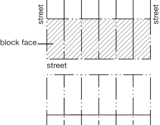
Figure 20.100-2
Terminology, Block Face
Block Face
All parcels abutting one side of a street between the two nearest intersecting streets.
Body of Water, Other
Ponds and reservoirs greater than 4,356 square feet that do not support fish, and
drainage systems, discharging directly into streams, pond or other surface water.
Swimming pools, irrigation ditches and water bodies used solely for treating, transporting,
or impounding pollutants are not considered "other body of water."
Buffer Area
An area of varying width extending from the edge of a stream, wet meadow, woody draw,
wetland or other body of water and land containing any of the habitat or community
types listed in 20.50.030.H, where development may have a negative impact on wildlife
habitat, water quality and quantity, fish, or other aquatic resources.
Building
Any structure having a roof supported by columns or walls and intended for the shelter,
housing or enclosure of any person, animal, process, vehicle, equipment, goods or
material of any kind or nature; and, when separated by a party wall without openings,
it will be deemed a separate building.
Building and Disturbance Area
That area of a parcel on which any principal buildings will be located (i.e., building
footprint) or on which any of the following will occur:
A.
Grading of more than 50 cubic yards of cut or fill or cut or fill of more than two feet below or above existing grade; or
B.
Removal of one or more trees with a diameter-at-breast height of six inches or greater.
Building Frontage
See 20.75.170.D.
Building Graphics
Any mosaic, mural or painting or graphic art technique or combination or grouping
of mosaics, murals or paintings or graphic art techniques that has artistic merit,
is not associated with the business being conducted, is unique in design to the community,
reflects the heritage of Missoula and is applied or implanted directly onto a wall
or fence.
Building-Integrated System
A solar photovoltaic system that is constructed as an integral part of a principal
or accessory building or structure and where the building-integrated system features
maintain a uniform profile or surface of vertical walls, window openings and roofing.
Such a system is used in lieu of a separate mechanical device, replacing or substituting
for an architectural or structural component of the building or structure that appends
or interrupts the uniform surfaces of walls, window openings and roofing. A building-integrated
system may occur within vertical facades, replacing view glass, spandrel glass or
other facade material; into semitransparent skylight systems; into roofing systems,
replacing traditional roofing materials; or other building or structure envelope systems.
Building Line
An imaginary line representing the vertical projection (or plumb line) of an exterior
building wall that encloses interior floor space.
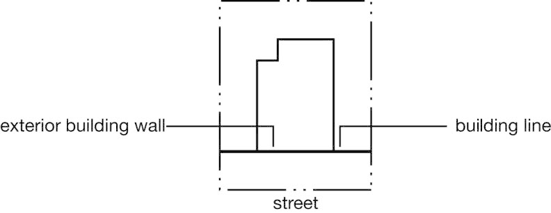
Figure 20.100-3 Terminology, Building Line
Building Site
A parcel used or intended to be used for building or development.
Cabaret License
A license issued by the State Department of Revenue pursuant to Montana State law
that allows restaurants, cafes or eating establishments to serve beer and wine to
patrons who purchase food, when at least 65% of its gross annual income is derived
from the sale of food. Gaming and gambling are prohibited (also known as a "restaurant
beer/wine (RB/W) license").
Cannabis
A term used in this zoning code replacing the term "marijuana" used in state statutes
and defined by the State of Montana (MCA § 16-12-102). The term does not include hemp
as defined in state law (MCA § 16-12-102).
Cannabis, Canopy
The total amount of square footage dedicated to live plant production at a registered
premises consisting of the area of the floor, platform, or means of support or suspension
of the plant.
Cannabis, Cultivation
The growing, harvesting, and curing of cannabiscannabis.
Cannabis, dispensary
A retail facility where cannabiscannabis, and cannabis productscannabis products are sold.
Cannabis, Manufacturing
The converting or compounding of cannabiscannabis into cannabis productscannabis products, cannabiscannabis concentrates, or cannabiscannabis extracts.
Cannabis, Products
Products containing THC, derived from cannabiscannabis, for consumption. The term does not include hemp as defined in State law (MCA § 16-12-102).
Cannabis, recreational
A term used in this zoning code replacing the term "adult-use" used in state statues
and defined by the State of Montana (MCA § 16-12-102).
Cannabis, Tier
The canopycanopy square footage allotted by the State of Montana based on state guidelines found in
MCA § 50-46-305.
Canopy
A permanent roof-like shelter constructed of some durable material such as metal,
glass, plastic or weather-resistant fabric that may be free standing or attached to
a building.
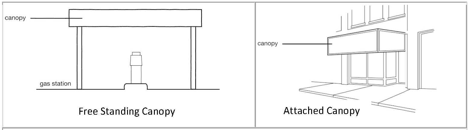
Figure 20.100-4 Terminology, Canopy

Figure 20.100-5
Terminology, Channel Letter
Channel Letter
A fabricated or formed three-dimensional letter, number or symbol.
Collocation
The act of siting facilities on an existing structure without the need to construct
a new support structure and without a substantial change (20.40.160.G) in the size
of an existing personal wireless service facility.
Commercial Message
Any sign, wording, logo, or other representation that directly or indirectly, names,
advertises, or calls attention to a business, product, service or other commercial
activity.
Completely Enclosed Building
A building separated on all sides from the adjacent open space, or from other buildings
or other structures, by a permanent roof and by exterior walls or party walls, pierced
only by windows and normal entrance or exit doors.
Comprehensive Design Plan
Building design and signs integrated into one architectural plan, the comprehensive
plan being complete in all other building, structural and electrical requirements
(see 20.75.100).
Conditional Use
A use that is allowed only if reviewed and approved in accordance with the conditional
use procedures of 20.85.070.
Construction
Any grading, excavation, cutting or filling of material or other disturbance that
results in a travel-way for motorized or non-motorized vehicles or the site for a
building, structure or landscaping.
Copy (Permanent and Temporary)
The wording on a sign surface, either in permanent or removable-letter form.
Copy Change
The replacement of inserts within sign frames, modules or cans, but does not include
any alteration or replacement of the sign frame, modules or cans.
Corner Parcel
A parcel situated at the intersection of two streets, the interior angle of such intersection
not exceeding 135 degrees.
Corporate Color
Any color part of a trademark or service mark used by a company, including any similar
color described in ordinary language such as red or maroon.
Courtyard
A landscaped outdoor space surrounded on at least three sides by building walls.
Cut and Fill
Excavation of material from one place (cut) to be deposited (as fill) in another place.
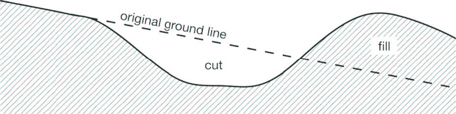
Figure 20.100-6 Terminology, Cut and Fill
Day
Calendar day, unless otherwise expressly stated (see also 20.01.090.B).
Density
The number of dwelling units occupying a given amount of land area.
Detached House
A principal building that contains only one principal dwelling unit and that is located
on a single parcel with private yards on all sides of the building. See 20.05.030.
Development
Any man-made change to real estate or property, including buildings, fences, or other
structures, mining, dredging, filling, grading, paving, excavating or drilling.
Development Application
Any application or petition for approval in accordance with the procedures of Chapter 20.85 or similar procedures under this zoning ordinance for approval of a permit or application
to commence land clearing, grading, building or development.
Diameter-at-Breast Height (DBH)
Tree trunk diameter measured at a height of 4.5 feet above grade level at the base
of the tree.
Distributed Antenna System (DAS)
A distributed antenna system network consisting of one or more nodes connected by
a fiber system to a carrier's base transceiver station or other location commonly
referred to in the communications industry as an "eNodeB", or "NodeB", or similar
designation.
Drive-through Facility
Any service window, automated device or other facility that provides goods or services
to individuals in a motor vehicle.
Dwelling Unit
A single unit providing complete, independent living facilities for one or more persons,
including permanent provisions for living, sleeping, eating, cooking and sanitation.
The intent is to be consistent with the building code.
Commentary: The presence of the following are indicators of a dwelling unit: counters, stove, refrigerator, sink, 220V electrical outlet, and bathroom including bathing facilities. In addition, the unit shall have independent access and no access from another dwelling unit. This is not an exhaustive list. One of these indicators on its own is not proof of a dwelling unit.
Dynamic Display
See "Sign, Dynamic Display."
Easement
Authorization by a property owner for use of all or a designated portion of the subject
property by another property owner or entity.
Equipment Enclosure
A structure, shelter, cabinet, or vault used to house and protect the electronic equipment
necessary for processing personal wireless service signals. Associated equipment may
include air conditioning, backup power supplies, emergency generators and other equipment
necessary for operation of the facility.
Erected
Attached, altered, built, constructed, reconstructed, enlarged or moved, and includes
the painting of walls, signs, or the relocation, placement or alteration of individual
sign letters, modules, or cans.
Erosion
The process by which the soil and rock components of the earth's crust are worn away
and removed from one place to another by natural forces such as water, wind, ice,
gravity, or artificial means.
Established Road
An existing access or haul route for motorized vehicles that is passable under one
or more of the following circumstances:
A.
As is;
B.
With surface blading;
C.
With replacement of stream crossing structures and drainage structures that were removed to restrict access; or
D.
With removal of constructed access barriers.
FAA
Federal Aviation Administration.
Façade
All the wall planes of a building seen from one side or view.
FCC
Federal Communications Commission.
Flashing
A pattern of changing light illumination where the sign illumination alternates suddenly
between fully illuminated and fully non-illuminated for the purpose of drawing attention
to the sign.
Floor Area
Same as "gross floor area," except as otherwise expressly stated.
Floor Area, Gross
The gross horizontal area of the subject space, measured from the interior faces of
any exterior walls or from the centerline of joint partitions. Unless otherwise expressly
stated, accessory buildings and parking and vehicular circulation areas within principal
buildings are not counted as gross floor area.
Floor Area, Gross Leasable
The total gross floor area designed for tenant occupancy and exclusive use, including
basements, mezzanines, and upper floors, if any, expressed in square feet and measured
from the interior faces of any exterior walls or from the center line of joint partitions.
Front Property Line
The property line that "faces" and is adjacent to the street. On corner parcels, the
front property line is the property line that is parallel to the alley that serves
the parcel. When no alley exists, the zoning officer is authorized to establish the
front property line and the street side property line. See 20.110.050.A.
Frontage (Street Frontage)
The boundary of a parcel that abuts a street right-of-way.
Garage
A covered structure designed to provide shelter for vehicles and that is accessory
to a use in the following residential building types: detached houses, townhouses,
two-unit houses, and multi-unit houses. Carports are considered garages. A garage
may be attached to or detached from the principal building.
Glazed area
That portion of a façade that is comprised of glass, including windows, glass block
walls and windows in doors.
Grade, Existing
The grade or elevation of the ground surface as approved with the final plat. In situations
when a final plat is not available or the elevation information is not available on
the final plat, existing grade is the grade the exists at the time of application
for building permit/zoning compliance permit.
Grade, Finished
The grade of a site after grading and building construction, inclusive of any retaining
walls, built up grade or other changes to existing grade.
Groundcover
Low-growing plants, deciduous or evergreen species that cover the ground, used instead
of turf. Plants that generally do not exceed 18 inches in height are classified as
groundcover.
Ground Floor
The first floor of a building (as measured from the lowest floor upward) that has
more than 50% of its floor-to-ceiling height above finished grade.
Ground-floor Entrance
A ground floor entrance where the door threshold is at finished grade or within three
feet of finished grade.
Ground-Mounted Solar Energy System
A solar energy conversion system that is mounted on a solar racking system, pole or
series of poles constructed specifically to support the solar collection system, not
attached to any other structure, and wired to connect to an adjacent home or building.
Hardiness Zones
There are 11 planting zones, or "USDA Plant Hardiness Zones," in the United States
and southern Canada. The USDA planting zones are regions defined by a ten degree Fahrenheit
difference in the average annual minimum temperature. The higher the number, the warmer
the temperatures for gardening in those planting zones.
Commentary: It is standard practice for seed dealers and nurseries to label their products according to their USDA planting zones.
Health Authorities
Montana Department of Environmental Quality and/or the Missoula City/County Health
Department.
Height, Plant Material
Plant height is measured from grade to the uppermost point of growth of the plant.
Hillside Land
Land that is subject to the hillside protection regulations of 20.50.010.
Home Occupation
An accessory use of a dwelling unit for business or commercial purposes. Home occupations
are subject to the standards of 20.45.050.
Household
One or more persons living, sleeping and usually cooking and eating on the premises
as a single housekeeping unit.
Hydrology
The properties of the water, including circulation and distribution, on and below
the ground.
Impervious Surface
Any surface that either prevents or retards the entry of water into the soil profile
(the area from ground surface to parent material bedrock), as under natural conditions
prior to development, and/or a surface area that causes water to run off the surface
in greater quantities or at an increased rate of flow from the flow present under
natural conditions prior to development. Surfaces that impede the natural infiltration
of surface and stormwater runoff are impervious. Drainage swales are not considered
impervious under this definition.
Illumination, External
A source of illumination that is not internal which lights the sign but which is largely
itself not visible to persons viewing the sign. The light fixture may be visible,
but the source of light should be largely not visible.
Illumination, Internal
A source of illumination entirely within the sign that makes the sign visible at night
by means of lighting the background, light being transmitted through a translucent
material or the character (i.e., letter) itself being opaque and thus silhouetted
against the background. The source of illumination may not be visible.
Interior Side Property Line
A side property line that does not abut a street or alley.
Kilowatt-hour (kWh)
A unit of energy equivalent to one kilowatt of power expended for one hour of time.
Landscape/Landscaping
The act of enhancing the appearance of the land by altering its contours and planting
trees, shrubs, vines, flowers, turf, groundcover and other plant materials for aesthetic
effect.
Landscape Plan
A legible drawing required for the purpose of determining compliance with the landscaping
regulations of Chapter 20.65.
Lawfully Established
A use, building, structure, parcel or sign (as the context indicates) that was established
in conformance with all applicable zoning and subdivision regulations in effect at
the time of its establishment.
Lot
A contiguous area of land with defined boundaries under common ownership created by
subdivision, subdivision exemption or their legal equivalent. TED Ownership Units
(TOUs) are not lots.
Lot Line House
A principal building containing one dwelling unit located on a single parcel that
is not attached to any other dwelling units. The building is shifted to one side of
the parcel so that there is a more usable side yard on one side of the house and very
little or no private yard on the other side. See also 20.05.030.
Low-Impact Development (LID)
A site design strategy with the goal of maintaining or replicating the pre-development
hydrologic regime through the use of design techniques to create a functionally equivalent
hydrologic site design. Through the use of LID techniques, hydrologic functions of
storage, infiltration and ground water recharge, as well as the volume and frequency
of discharges are maintained through the use of integrated and distributed micro-scale
stormwater retention and detention areas, reduction of impervious surfaces, and the
lengthening of runoff flow paths and flow time. Other strategies include the preservation/protection
of environmentally sensitive site features such as riparian resource areas, wetlands,
steep slopes, mature woodlands, floodplains, and highly permeable soils.
Malt Beverage
An alcoholic beverage made by the fermentation of an infusion or decoction, or a combination
of both, in potable brewing water, of malted barley with or without hops or their
parts or their products and with or without other malted cereals and with or without
the addition of unmalted or prepared cereals, other carbohydrates, or products prepared
from carbohydrates and with or without other wholesome products suitable for human
food consumption.
Manufactured Housing Unit
A factory-built, single-household structure that is manufactured under the authority
of 42 USC § 5401, the National Manufactured Home Construction and Safety Standards
Act, is built on a permanent chassis, and is used as a place for human habitation,
but that is not constructed or equipped with a permanent hitch or other device allowing
transport of the unit other than for the purpose of delivery to a permanent site,
and that does not have wheels or axles permanently attached to its body or frame.
This definition specifically does not include recreational vehicles.
Marquee
See "Canopy."
Microbrewery/Microdistillery
A brewery (for malt beverages) that has an annual nation-wide production as defined by State Law, MCA §§ 16-3-213.
An existing microbrewery that obtains a retail beer and wine sales permit may be co-located at the same location
as the microbrewery so long as:
1.
The primary use continues to be the microbrewery, and
2.
The operation shall close at the following times to mirror the general hours of operations of restaurants:
a.
10:00 p.m. on Sunday—Thursday, and
b.
11:00 p.m. on Friday—Saturday.
A distillery that has an annual production limit as defined in State Law, MCA §§ 16-4-310 through 16-4-312.
Note— Definition derives from Interim provisions of Ord. 3733 that expire March 25, 2025. The expiration date of said provisions were extended by Ord. 3769, 2025 to expire March 24, 2026.
Mixed-use Building
A building that houses residential uses in combination with nonresidential uses.
Mulch
Material applied to the soil surface to retain soil moisture, control erosion, inhibit
weeds, and/or regulate soil temperatures.
Multi-dwelling Building
A residential building containing three or more dwelling units (other than a three+
townhouse multi-dwelling house) that share common walls and/or common floors/ceilings.
Multi-dwelling buildings are typically served by one or more private or common building
entrances. See 20.05.030.
Multi-dwelling House
A residential building containing three to six dwelling units that share common walls
and/or common floors/ceilings. Multi-dwelling houses appear as large detached houses
and have only one entrance visible from the street. See 20.05.030.
Multi-Tenant Development
A development typically under unified ownership and control consisting of two or more
business establishments. The tenants of multi-tenant development typically share vehicle
access and parking facilities. A multi-tenant development may consist of a single
(multi-tenant) building or multiple buildings on a single development site.
Nonconforming Parcel
A lawfully created parcel, shown on a plat or survey map recorded in the office of
the County Clerk and Recorder that does not comply with all applicable minimum parcel
area or parcel width standards of the zoning district in which the parcel is located.
See 20.80.020.
Nonconforming Sign
A sign that was lawfully established, in accordance with all zoning and sign regulations
in effect at the time of its establishment but that is no longer allowed by the regulations
of this zoning ordinance. See 20.75.120.
Nonconforming Structure
Any building or structure, other than a sign, that was lawfully established but no
longer complies with the parcel and building standards of the zoning district in which
it is located. See 20.80.030.
Nonconforming Use
A land use that was lawfully established in accordance with all zoning regulations
in effect at the time of its establishment but that is no longer allowed by the use
regulations of the zoning district in which the use is now located. See 20.80.040.
Nonconformity
Any nonconforming parcel, nonconforming use, nonconforming structure or nonconforming
sign.
Non-motorized (Transportation) Facilities
Improvements designed for the use, safety and comfort of pedestrians, cyclists, equestrians
and similar forms of non-motorized transportation. Examples include sidewalks, walkways,
trails, bikeways and related appurtenances, such as signs and ramps.
Nonresidential District
Any zoning district other than a residential (R) district.
Offset
The horizontal distance measured between vertical surfaces of adjacent building elements.
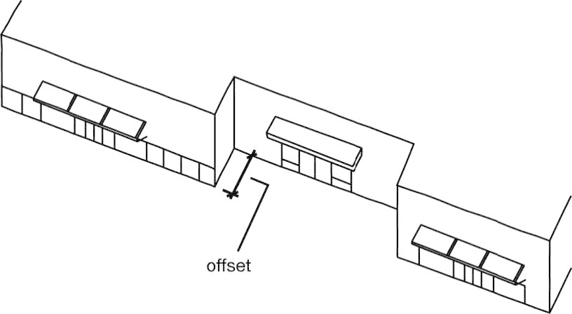
Figure 20.100-7 Terminology, Offset
Open-Air Uses
Storage yards, construction debris sites, used vehicle sales lots, vehicle impound
yards, auto wrecking, junkyards, and similar open-air uses when the only buildings
on the parcel are incidental and accessory to the open-air use of the parcel.
Open Porch or Deck
A porch or deck that is open on at least three sides and with at least 50% of the
total area of the vertical plane on those three sides unobstructed in any manner.
Outdoor Display Area
A portion of a parcel used for exhibiting in an orderly manner, completely assembled
or finished products sold by a retail business located on the same parcel pursuant
to an approved permit.
Outdoor Sales Area
An outdoor area used pursuant to an approved permit for the display or sales of seasonal
products, new merchandise or the supply of services.
Overlay District
A zoning district that overlays one or more base zoning districts and imposes requirements
in addition to those of the base district or modifies the standards otherwise applicable
in the base zoning district.
Parapet or Parapet Wall
For sign purposes, a wall-like barrier at the edge of a flat roof that acts as a vertical
extension of an exterior building wall that extends no more than eight feet above
the roof height of the building.
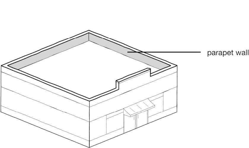
Figure 20.100-8 Terminology, Parapet or Parapet Wall
Parcel
A contiguous area of land that is designated by its owner, at the time of application
for a zoning compliance permit, as a site to be used, developed, or built upon as
a unit, under single ownership or control.
Commentary: Two or more abutting lots might, for example, be combined into a single parcel (sometimes referred to as a "zoning lot") by virtue of placing a building on the lots in a way that it spans the multiple lots. Under this example, applicable parcel and building standards (e.g., building setbacks) would apply to the parcel as a whole.
Parcel, Corner
See "Corner Parcel."
Parcel, Interior
A parcel whose side lines do not abut a street.
Parcel, TED
A tract of record that has received approval for a TED project that includes TED ownership
units, and may include public access easement roads and TED parks.
Parking Structure
A covered structure or portion of a covered structure, other than a "garage," that
provides parking for motor vehicles. See also "Garage."
Personal Wireless Services
Commercial wireless telecommunication services including cellular, personal communications
services (PCS), specialized mobilized radio (SMR), enhanced specialized mobilized
radio (ESMR), paging, and similar services that are marketed to the general public.
Personal Wireless Service Facility(ies) or (Facility(ies))
An un-staffed facility for the transmission and/or reception of radio frequency (RF),
microwave or other signals for commercial communications purposes, typically consisting
of an equipment enclosure, a support structure, transmission equipment, including
one or more antenna.
Personal Wireless Service Facilities, Abandoned
Any personal wireless communications facilities that are not utilized for the provision
of wireless communications services for a continuous period of six months will be
considered abandoned.
Personal Wireless Services Facility Existing
Previously erected, or any lawfully constructed, personal wireless services facility.
Personal Wireless Service Facilities Support Structure
The structure or surface upon which an antenna is mounted, including the following
types:
A.
Ground-mounted: Mounted on the ground and built for the sole purpose of supporting antenna and their associated equipment.
B.
Roof-mounted: Mounted on the roof of a building.
C.
Structure-mounted: Mounted on a structure not constructed or erected for the primary purpose of supporting wireless communication antennae.
Personal Wireless Service Facilities Support Structure, Height
The vertical distance measured from the base of the support structure to the highest
point of the structure.
A.
Ground-mounted support structure height is measured from existing grade and includes the antenna.
B.
Roof-mounted support structure height does not include the height of the building on which the new structure is mounted.
C.
Structure-mounted support structure height does not include the height of the host structure on which the new structure is mounted.
Pitch, (Roof)
The slope and inclination angle of a roof measured as vertical rise divided by the
measured horizontal span.
Pond
A body of water supportive of aquatic life. Wave action is minimal, allowing emergent
vegetation to establish.
Primary Roof Pitch
The pitch of the majority of the surface area of a building's roof, not including
dormers.
Principal Building
A building or combination of buildings of chief importance or function on a parcel.
In general, the principal use is carried out in a principal building.
Principal Use
An activity or combination of activities of chief importance on the parcel. One of
the main purposes for which the land, buildings or structures are intended, designed,
or ordinarily used.
Product Display Window
An illuminated window display area in which products and goods are displayed to pedestrians
but that do not generally allow visibility into the interior of the building.
Property Line
The boundary of a parcel, as shown on a subdivision plat or on a survey represented
by the parcel's owner or developer as the boundary of the parcel to be used, developed,
or built upon as a unit, under single ownership or control.
Public Safety
Police, fire, ambulance and other emergency dispatch services provided through personal
wireless services.
Public Utility Installation
An unoccupied structure or facility used in conjunction with the supply of public
utility services, including heat, light, power, water, telegraph, telephone, railway
service and sewer service, but does not include a personal wireless service facility
not specifically exempted by Chapter 20.40.160.
Pump Top Unit
Integrated equipment on the top of a gas pump structure intended to be used as advertising
space by use of electronic video display.
Rear Property Line
That property line that is most distant from and is most parallel to the front property
line.
Commentary: Not all parcels have rear property lines.
Residential Building
A detached house, townhouse, two-unit house, multi-dwelling house, multi-dwelling
building or vertical mixed-use building.
Roof-Mounted Solar Energy Conversion Systems
A solar power system in which solar panels are mounted on top of the structure of
a roof either as a flush-mounted system or as modules fixed to frames which can be
tilted toward the south at an optimal angle.
Runoff
That part of precipitation that flows off the land without filtering into the soil
or being absorbed by plant material.
Satellite Dish Antenna
A device designed or used for the reception or the transmission of television or other
electric communication signal broadcast or, relayed from a satellite. It may be a
solid, open mesh, or bar configured structure, in the shape of a shallow dish or parabola.
Sediment
Solid material, both mineral and organic, that is in suspension, is being transported,
or has been moved from its site of origin by air, water, or gravity as a product of
erosion.
Sedimentation
The process of depositing materials from a liquid, especially in bodies of water.
Setback
An open, unobstructed area that is required by this zoning ordinance to be provided
from the furthermost projection of a structure to the property line of the parcel
on which the building is located. See 20.110.050 for additional regulations regarding measurement of setbacks and exceptions to setback
rules.
Setback, Front
The minimum setback required between a building and the front property line of the
parcel on which the building is located, extending along the full length of the front
property line between the side property lines. See 20.110.050.A for exceptions and
rules of measurement.
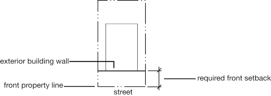
Figure 20.100-9 Terminology, Setback, Front
Setback, Rear
The minimum setback required between a building and the rear property line of the
parcel on which the building is located, extending along the full length of the rear
property line between the side property lines. See 20.110.050.A for exceptions and
rules of measurement.
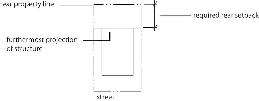
Figure 20.100-10 Terminology, Setback, Rear
Setback, Side
The minimum setback required between a principal building and the side property line
of the parcel on which the building is located, extending along a side property line
from the point of the minimum front setback to the point of the minimum rear setback.
See 20.110.050.A for exceptions and rules of measurement.
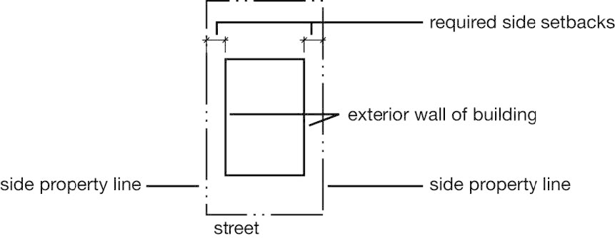
Figure 20.100-11 Terminology, Setback, Side
Setback, Street Side
The minimum setback required between a principal building and the street side property
line of the parcel on which the building is located.
Side Property Line
Any property line that is not a front property line or a rear property line.
Sidecasting
The act of moving excess earthen material over the sides of a road during road maintenance
operations or excavation for structural improvements.
Sign
Any identification, description, illustration or device, illuminated or non-illuminated,
that is visible from any public place or is located on private property and exposed
to the public and that directs attention to a product, service, place, activity, person,
institution, business or solicitation, including any permanently installed or situation
merchandise; or any emblem, painting, banner, pennant, placard or temporary sign designed
to advertise, identify or convey information, with the exception of window displays,
and flags emblems, crests or insignia of any nation, or governmental subdivision.
The term sign also includes the sign's structure.
Sign, Abandoned
A sign that no longer correctly directs or exhorts any person, advertises a bona fide
business, lessor, owner, product or activity conducted or product available on the
premises where the sign is displayed.
Sign, Address
A sign identifying the street address of the subject property.
Sign, Animated
Any sign that uses movement or change of lighting to depict action or create a special
effect or scene.
Sign Area
The area of a sign including the area within a perimeter that forms the outside shape
including the frame, forming an integral part of the display, but excluding the necessary
supports or uprights on which the sign may be placed. The sign area may also include
background corporate color.
Sign, Awning
A sign painted on, printed, or otherwise attached flat against the surface of an awning.
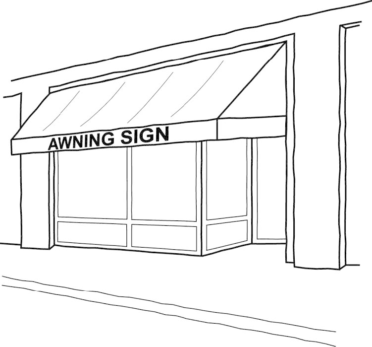
Figure 20.100-12 Terminology, Sign, Awning
Sign, Banner
A temporary sign made of fabric, or any non-rigid material, secured or mounted on
a wall or fence so as to prevent movement of the sign caused by movement of the atmosphere.
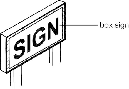
Figure 20.100-13
Terminology, Sign, Box
(Also Known as "Cabinet Sign")
Sign, Box (Also Known as "Cabinet Sign")
A sign with text or symbols printed on plastic, an acrylic sheet or similar material
(including "flex face," fabric-like material) that is mounted on a cabinet or box
that houses any lighting source and equipment.
Sign, Building as a
Building as a sign refers to when a building's design is integrated and coordinated
with its signage scheme so that the building itself becomes the sign. Color, lighting,
and architectural details that match the business' logo and signage create an overall
effect that functions as a sign instead of architecture.
Sign, Changeable Copy
A manual changeable copy sign or a dynamic display.
Sign, Directional
Any sign that serves solely to designate the location or direction of any place or
area.
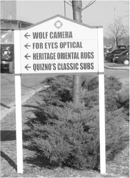
Figure 20.100-14 Terminology, Sign, Directory
Sign, Directory
A sign on a multi-tenant development site that is used to convey directions or tenant
information to pedestrians and motorists who have entered the site.
Sign, Dynamic Display
Signs capable of displaying words, symbols, figures, or images that can electronically
or mechanically changed by remote or automatic means.
Sign, Ground
A sign erected on a freestanding frame, mast, or pole and not attached to any building.
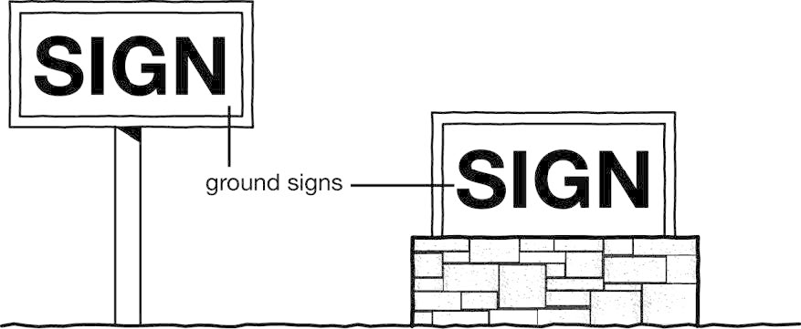
Figure 20.100-15 Terminology, Sign, Ground
Sign, Hanging
A sign that is suspended below the ceiling, roof, awning, canopy, marquee, or floor
overhang.
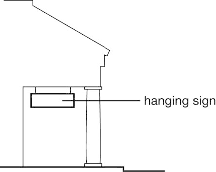
Figure 20.100-16 Terminology, Sign, Hanging
Sign Height
The vertical distance measured from the adjacent street grade or upper surface of
the nearest street curb, other than an elevated roadway, to the highest point of the
sign.
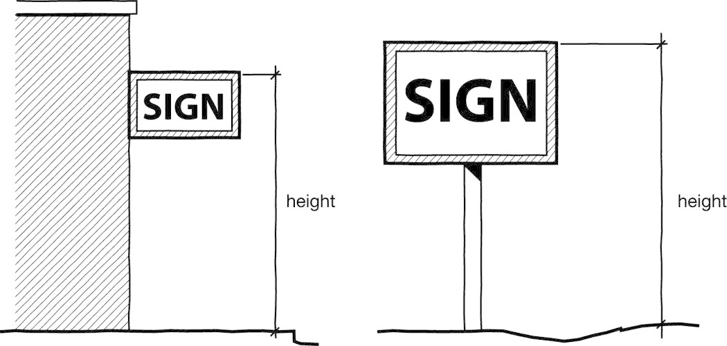
Figure 20.100-17 Terminology, Sign Height
Sign, Heritage
A heritage sign is one that employs distinctive graphics, symbols and lighting that
is a unique design to the community and are historically-accurate, reflecting the
heritage of Missoula. Heritage signs maybe in the form of nonconforming signs or new
signs that do not fit within the typical definition and measurements of wall, ground,
or other sign.
Sign, Ideological
A sign communicating a message or ideas for non-commercial purposes.
Sign, Incidental
A sign intended to indicate the types of credit cards accepted, an establishment's
hours of operation or other similar information that pertain to the premises where
the sign is located. Incidental signs cannot be freestanding.
Sign, Inflatable
Any sign which uses compressed or forced gas to provide movement and/or support.
Sign, Manual Changeable Copy
A sign that has a reader board for the display of text information in which each alphanumeric
character, graphic or symbol may be changed or re-arranged manually without altering
the face or the surface of the sign.
Sign, Menu Board
A sign displaying goods or services available through a drive-up window or available
through a drive-in or drive-through establishment.
Sign, Minor
An on-premises sign that does not exceed six square feet in area and is intended to
designate the direction or location of any place or area.
Sign Multi-tenant
A sign on a multi-tenant development site that is intended to convey tenant information
to pedestrians and motorists who have entered the site.
Sign, Nameplate
A nonelectric sign, not exceeding 144 square inches in area, identifying only the
name and occupation or profession of the occupant of the premises on which the sign
is located. If any premises includes more than one occupant, "nameplate" refers to
all names and occupations or professions as well as the name of the building and directional
information.
Sign, National Register District Identification
A sign provided by the Montana Historical Society that identifies an historic resource
listed in the National Register of Historic Places.
Sign, Nonconforming
A sign that was lawfully established, in accordance with all zoning and sign regulations
in effect at the time of its establishment but that is no longer allowed by the regulations
of this zoning ordinance. See 20.75.120.
Sign, Off-Premises
Any sign advertising goods or services that are not available on the parcel on which
the sign is located (see also "Billboard").
Sign, On-Premises
Any sign identifying or advertising a business, person, activity, goods, products
or service, as permitted by this chapter, and located on the premises where the sign
is installed and maintained.
Sign, Panel
A panel sign is a flat board, of any number of materials, on which copy is placed
and then the panel is mounted on the face of a building.
Sign, Pole
(See " Sign, Ground").
Sign, Political
A sign pertaining to candidates or issues and directed toward the ultimate exercise
of voting by the general public, and is a type of ideological sign.
Sign, Projecting
A sign, other than a wall sign, that is attached to and projects from a structure
or building face.
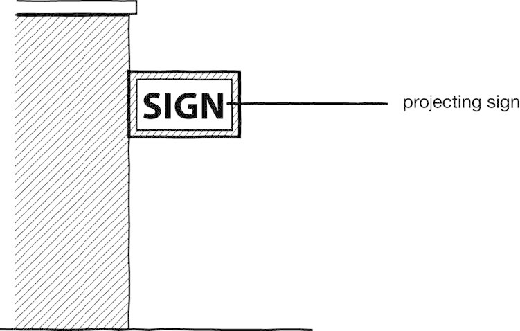
Figure 20.100-18 Terminology, Sign, Projecting
Sign, Real Estate or Property for Sale, Rent or Lease
Any sign pertaining to the sale, lease, or rental of land or buildings.
Sign, Roof
Any sign erected upon, against or directly above any portion of the roof, except signs
on parapet walls. Any sign on a parapet wall is considered a roof sign if any portion
of the sign is above the parapet wall.
Sign, Seasonal or Holiday
Signs such as Christmas decorations, those used for historic holidays, and installed
for a limited period of time.
Sign, Sidewalk
A sign that rests on the ground, and that is not permanently attached to the ground
or other structure.
Sign, Stacking Lane
A sign displaying goods or services available through a drive-up window or available
through a drive-in or drive-through establishment.
Sign Structure
Any structure that supports, has supported or is capable of supporting a sign, including
decorative cover.
Sign, Temporary
A sign constructed of cloth, canvas, vinyl, paper, plywood, fabric, or other lightweight
materials not well suited to provide a durable substrate or, if made of some other
material is neither permanently installed in the ground nor permanently affixed to
a building or structure. When made of non-rigid material, temporary signs must be
enclosed in a rigid frame. Temporary signs are intended to be signs such as yard sale,
for rent, for sale, construction, development, and special event.
Sign, Vehicle
Vehicles and trailers existing for the primary purpose of on-premises and off-premises
advertising. Commercial transportation vehicles that are licensed, self-propelled,
in compliance with State and City statute and/or ordinance requirements and are operating
in the function for which they are intended are not subject to this prohibition. This
definition shall not limit political signs mounted on vehicles.
Sign, Wall
A sign attached to or erected against the wall of a building with the face in a parallel
plane to the place of the building wall, including a sign attached to a parapet wall
that may be constructed specifically for the purpose of attaching a sign.
Sign, Wind
An attention-getting device with or without copy, or a series of devices such as flags
(excluding those flags in Subsection 20.75.040.G), including feather flags, pennants,
streamers, spinners, balloons and inflatables with or without copy, fastened in such
a manner as to move in the wind.
Sign, Window
A sign installed inside a window for purposes of viewing from outside the premises.
This term does not include merchandise located in a window.
Single-purpose Residential Building
A detached house, lot line house, townhouse, two-unit house, multi-dwelling house,
multi-dwelling building, or any other principal building containing residential dwelling
unit(s) other than vertical mixed-use.
Slide
The downhill mass movement of soil, rock, or snow resulting from failure of that material
under stress.
Slope
The inclination of the surface of the land from the horizontal.
Small Cell Network(s)
A network consisting of one or more nodes connected, directly or indirectly, by fiber
to a carrier's mobile switching center or other point of interconnection.
Solar Energy Conversion System (SECS)
The components and subsystems required to convert solar energy into electric or thermal
energy suitable for use. The area of the system includes all the land inside the perimeter
of the system, which extends to any fencing. The term applies, but is not limited
to, solar photovoltaic (PV) systems, solar thermal systems, and solar hot water systems.
1.
Small-Scale, Solar Energy Conversion System: An active SECS that occupies 2,500 square feet of surface area or less (equivalent to a rated nameplate capacity of about 25 kW DC or less).
2.
Medium-Scale, Solar Energy Conversion System: An active SECS that occupies more than 2,500 but less than 40,000 square feet of surface area (equivalent to a rated nameplate capacity of about 25 - 250 kW DC).
3.
Large-Scale, Solar Energy Conversion System: active SECS that occupies more than 40,000 square feet of surface area (equivalent to a rated nameplate capacity of about 250 kW DC or greater).
Solar Panels
Devices containing photovoltaic cells that convert sunlight into direct current electricity
or that use thermal energy from sunlight to heat water.
Split-Zoned
Classification of a single parcel into two or more base zoning districts. See also
20.01.100.E.
Stream
A natural watercourse of perceptible extent that has a generally sandy or rocky bottom
of definite banks and that confines and conducts continuously or intermittently flowing
water.
Street Side Property Line
The side property line that "faces" and is adjacent to a street on a corner parcel.
The street side property line is the property line that is generally perpendicular
to the alley that serves the parcel. When no alley exists, the zoning officer is authorized
to establish the front property line and the street side property line. See also 20.110.050.A.
Structural Alteration
Any change in the supporting members of a building, such as bearing walls or partitions,
columns, beams or girders.
Structure
Anything constructed or erected, that requires location on the ground, or attached
to something having a location on the ground, including but not limited to, buildings,
signs, billboards and poster panels, but excluding fences and retaining walls.
Subsidence
Gradual downward, local, mass movement of the earth's surface.
Support Structure Replacement
Constructing a new support structure of proportions and of equal height or such other
height that would not constitute a substantial change to an existing support structure
in order to support a facility or to accommodate collocation and removing the existing
support structure.
TED Ownership Unit
A parcel created through Townhome Exemption (MCA § 76-3-203) that includes the land
beneath each dwelling unit and can include land adjacent to each dwelling unit as
shown in the approved Townhome Declaration Site Plan. Only one dwelling unit is associated
with each TED ownership unit. TED Ownership Units (TOUs) are not lots.
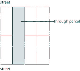
Figure 20.100-19 Terminology, Through Parcel
Through Parcel
A parcel with opposing property lines along two more or less parallel streets.
Topography
Characteristics of the ground surface such as plains, hills, mountains; degree of
relief, steepness of slope, and other physiographic features.
Tourist Home Unit
One dwelling unit (20.100.010) that is being used as a tourist home.
Tower
Any ground-mounted support structure and associated on-site fencing, equipment, switches,
wiring, cabling, power sources, shelters, or cabinets associated with that tower,
but not installed as part of an antenna as defined herein. A tower is also considered
a personal wireless facility.
Townhome Exemption Development (TED)
A residential development containing one or more dwelling units that are owned subject
to an arrangement under which persons own their own dwelling units and hold separate
title to the land beneath their dwelling units but under which they may jointly own
the common area and facilities in accordance with MCA §§ 70-23-102 and 76-3-203.
Townhouse
A residential building containing multiple dwelling units, each located on its own
parcel or TED ownership unit with a common or abutting wall along shared property
lines or TED ownership unit boundaries. Each dwelling unit has its own external entrance.
See 20.05.030.
Trail
A path designed for non-motorized travel.
Transmission Equipment
Equipment that facilitates transmission for any Commission-licensed or authorized
wireless communication service, including, but not limited to, radio transceivers,
antennas, coaxial or fiber-optic cable, and regular backup power supply.
Two-unit House
A residential building containing two dwelling units, both of which are located on
a single parcel (also referred to as a "duplex" or "two-flat"). The dwelling units
are attached and may be located on separate floors or side-by-side. See 20.05.030.
Vehicular Use Area
Any area on a parcel that is not located within any enclosed or partially enclosed
building and that is devoted to a use by or for motor vehicles including parking,
storage of automobiles, trucks or other vehicles, gas stations, car washes, vehicle
repair establishments, loading areas, drive-through service areas, and access drives
and driveways.
Vertical Mixed-Use Building
Buildings that meet all of the following criteria:
A.
Dwelling units occupy at least 50% of the building's gross leasable floor area;
B.
The minimum required square footage of nonresidential uses is determined based on one of the following options:
1.
Twenty percent of the parcel area; or
2.
50% of the ground floor space as described in C. below.
C.
The floor-to-floor height of the ground floor space is at least 10 feet except those areas not being used or capable of being used for commercial purposes including, but not limited to, storage areas, stairwells and elevator shafts, bathrooms, mechanical equipment rooms, and interior vehicular parking or loading.
Wet Meadow
A herbaceous wetland on mineral soil. Generally, wet meadows occur in seasonally flooded
basins and flats. Soils are usually dry for part of the growing season.
Wetlands
Those areas that are inundated or saturated by surface or groundwater at a frequency
and duration sufficient to support, and under normal circumstances do support, a prevalence
of vegetation typically adapted for life in saturated soil conditions. Wetlands include
marshes, swamps, bogs, and similar areas.
Wind Energy Conversion System (WECS)
A device that directly converts wind energy into usable thermal, mechanical, or electrical
energy, including such devices as windmills and wind turbines. The "system" includes
towers and supporting structures and directly connected facilities such as generators,
alternators, inverters, batteries, and associated control equipment.
Woody Draw
Areas that support woody vegetation, such as tall shrub and tree species, in small
intermittent and ephemeral drainages. The vegetation is a result of higher moisture
availability than the surrounding area. The duration of surface water, however, is
shorter than that of other streamside riparian areas (e.g., cottonwood and dogwood
communities).
Yard
The actual (as opposed to "required") horizontal distance that exists between a principal
building and a property line. See also "Setback."
Yard, Front
The yard that exists between a principal building and the front property line of the
parcel on which the building is located, extending along the full length of the front
property line between the side property lines.
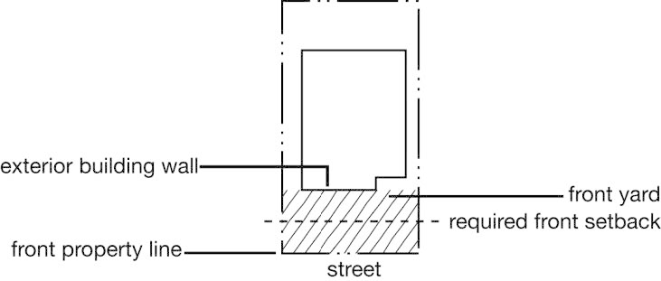
Figure 20.100-20 Terminology, Yard, Front
Yard, Rear
The yard that exists between a principal building and the rear property line of the
parcel on which the building is located, extending along the full length of the rear
property line between the side property lines.
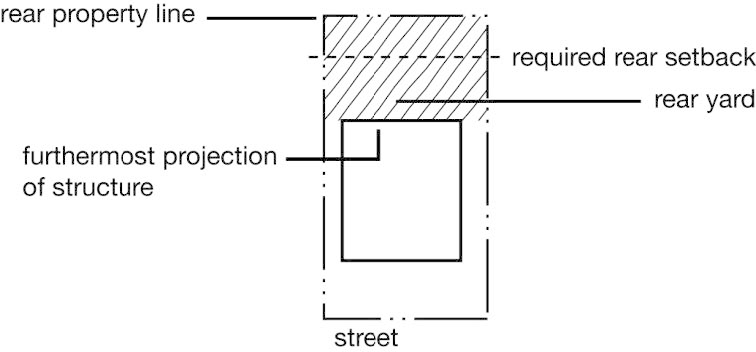
Figure 20.100-21 Terminology, Yard, Rear
Yard, Side
The yard that exists between a building and the side property line of the parcel on
which the building is located, extending along a side property line from the point
of the minimum front setback to the point of the minimum rear setback.
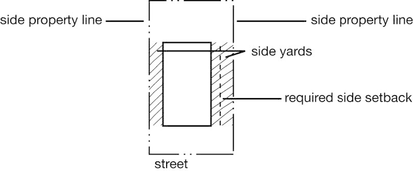
Figure 20.100-22 Terminology, Yard, Side
(Ord. 3769, 2025; Ord. 3735, 2024; Ord. 3733, 2024; Ord. 3723, 2023; Ord. 3689, 2021; Ord. 3669, 2020; Ord. 3648, 2019; Ord. 3609, 2018; Ord. 3600, 2017; Ord. 3586, 2016; Ord. 3574, 2016; Ord. 3570, 2016; Ord. 3511, 2013; Ord. 3471, 2011; Ord. 3469, 2011; Ord. 3439, 2010; Ord. 3410, 2009)
Accessory Building
A building that is subordinate in area, extent or purpose to the principal use and building on the parcel and that is customarily used in conjunction with a permitted accessory use. (See also the accessory use/structure regulations of Chapter 20.45.)
Accessory Dwelling Unit
A separate dwelling unit within a detached house or a separate dwelling unit that occupies an accessory building that shares a parcel with a detached house. As the name implies, accessory dwelling units are an accessory use to the principal use of the property (i.e., a detached house). (See also the accessory dwelling unit regulations of 20.45.060.)
Accessory Structure
A structure that is subordinate in area, extent or purpose to the principal use and building on the parcel and that is customarily used in conjunction with a permitted accessory use. (See also the accessory use/structure regulations of Chapter 20.45.)
Accessory Use
The use of any land, building or structure that is customarily associated with and incidental and subordinate to the principal use located on the same parcel (Chapter 20.45).
Administrative Adjustment
Modification of an otherwise applicable standard, approved in accordance with 20.85.110.
Affordable Housing
For the purposes of Title 20, affordable housing means a development that has been approved by the Office of Housing and Community Development, as a Tier 1 or Tier 2 project within the affordable housing incentive program established by the Office of Housing and Community Development.
Single Dwelling Unit Development Incentive Tiers
For Sale
Tier 1 - For sale housing below 80% AMI*, rental housing below 60% AMI
Tier 2 - For sale housing below 120% AMI, rental housing below 80% AMI or Voucher preference unit
Multiple Dwelling Unit Development Incentive Tiers
Rental
Tier 1 - 75% of units below 60% AMI or qualifying LIHTC projects
Tier 2 - 25% of units below 80% AMI
Ownership
Tier 1 - 10% of units below 80% AMI, 25% at 120% AMI in projects <10 units
Tier 2 - 25% of units below 120% AMI
* AMI Area Median Income for the Missoula area as defined by the U.S. Department of Housing and Urban Development and administered by Missoula Housing and Community Development.
Agent
A person duly authorized to act on behalf of the subject property owner.
Agricultural Land
Land used for agriculture or having a soil type defined by the Natural Resources Conservation Service as having agricultural importance, including prime farmland, farmland of state-wide importance, and farmland of local importance.
Alley
A public right-of-way that affords a means of access to abutting property, generally secondary in nature.
Antenna
Any equipment or devise used for the purpose of collecting or transmitting electromagnetic waves, including but not limited to directional antenna such as panels, micro-cells, small cell antennas, antennas for distributed antenna systems (DAS) microwave dishes, and satellite dishes, and omni-directional antenna such as whip antenna but not including satellite earth stations.
Area of Riparian Resource
A stream or other body of water, wet meadow, woody draw, or wetland and land containing any of the habitat or community types listed in 20.50.030.H, also including the adjacent buffer area.
Artist Live/Work Space
A dwelling unit in which up to 50% of the floor area is used for the production, showing, or sale of art.
Attached
Two or more structures are considered attached when they share at least part of a common wall or are connected by structural elements such as a covered porch, portico or passageway, the roof of which is an extension of the principal building or designed to be visually integrated.
Awning
A roof-like structure of rigid material or fabric or similar non-rigid material attached to a rigid frame that is supported completely or partially by either an exterior building wall or wall exterior to an individual tenant space.
Figure 20.100-1 Terminology, Awning
Base (Zoning) District
Any zoning district that is not an overlay district.
Bay Window
A building projection that: (1) is primarily comprised of a large window or series of windows; (2) is not supported by a building foundation beneath the window; and (3) has glazing over at least 33% of its vertical surface area.
Best Management Practices (BMPs)
Products, techniques, or methods that have been shown to be the most reliable and effective way to minimize adverse impacts on natural resources, particularly stormwater quality.
Billboard
A sign designed to advertise products, services or businesses not necessarily located on the premises on which the sign is located. A sign will not be considered "billboard" unless the sign is designed with a surface on which temporary poster panels or bulletins are mounted for the purpose of conveying a commercial or noncommercial message.
Billboard, Dynamic Display
A billboard with a dynamic display. (See "Sign, Dynamic Display" for definition of "Dynamic Display.")
Billboard, Mobile
A billboard mounted on an operable motor vehicle or trailer that travels over public streets or is parked on private property. Commercial vehicles used in the day-to-day operation of a business that display text, logos, or any other images related solely to the operation of the subject business (e.g., business names or logo on delivery vehicles) are not mobile billboards. Public transportation vehicles (e.g., Mountain Line buses and taxis) are not mobile billboards.
Figure 20.100-2
Terminology, Block Face
Block Face
All parcels abutting one side of a street between the two nearest intersecting streets.
Body of Water, Other
Ponds and reservoirs greater than 4,356 square feet that do not support fish, and drainage systems, discharging directly into streams, pond or other surface water. Swimming pools, irrigation ditches and water bodies used solely for treating, transporting, or impounding pollutants are not considered "other body of water."
Buffer Area
An area of varying width extending from the edge of a stream, wet meadow, woody draw, wetland or other body of water and land containing any of the habitat or community types listed in 20.50.030.H, where development may have a negative impact on wildlife habitat, water quality and quantity, fish, or other aquatic resources.
Building
Any structure having a roof supported by columns or walls and intended for the shelter, housing or enclosure of any person, animal, process, vehicle, equipment, goods or material of any kind or nature; and, when separated by a party wall without openings, it will be deemed a separate building.
Building and Disturbance Area
That area of a parcel on which any principal buildings will be located (i.e., building footprint) or on which any of the following will occur:
A.
Grading of more than 50 cubic yards of cut or fill or cut or fill of more than two feet below or above existing grade; or
B.
Removal of one or more trees with a diameter-at-breast height of six inches or greater.
Building Frontage
See 20.75.170.D.
Building Graphics
Any mosaic, mural or painting or graphic art technique or combination or grouping of mosaics, murals or paintings or graphic art techniques that has artistic merit, is not associated with the business being conducted, is unique in design to the community, reflects the heritage of Missoula and is applied or implanted directly onto a wall or fence.
Building-Integrated System
A solar photovoltaic system that is constructed as an integral part of a principal or accessory building or structure and where the building-integrated system features maintain a uniform profile or surface of vertical walls, window openings and roofing. Such a system is used in lieu of a separate mechanical device, replacing or substituting for an architectural or structural component of the building or structure that appends or interrupts the uniform surfaces of walls, window openings and roofing. A building-integrated system may occur within vertical facades, replacing view glass, spandrel glass or other facade material; into semitransparent skylight systems; into roofing systems, replacing traditional roofing materials; or other building or structure envelope systems.
Building Line
An imaginary line representing the vertical projection (or plumb line) of an exterior building wall that encloses interior floor space.
Figure 20.100-3 Terminology, Building Line
Building Site
A parcel used or intended to be used for building or development.
Cabaret License
A license issued by the State Department of Revenue pursuant to Montana State law that allows restaurants, cafes or eating establishments to serve beer and wine to patrons who purchase food, when at least 65% of its gross annual income is derived from the sale of food. Gaming and gambling are prohibited (also known as a "restaurant beer/wine (RB/W) license").
Cannabis
A term used in this zoning code replacing the term "marijuana" used in state statutes and defined by the State of Montana (MCA § 16-12-102). The term does not include hemp as defined in state law (MCA § 16-12-102).
Cannabis, Canopy
The total amount of square footage dedicated to live plant production at a registered premises consisting of the area of the floor, platform, or means of support or suspension of the plant.
Cannabis, Cultivation
The growing, harvesting, and curing of cannabiscannabis.
Cannabis, dispensary
A retail facility where cannabiscannabis, and cannabis productscannabis products are sold.
Cannabis, Manufacturing
The converting or compounding of cannabiscannabis into cannabis productscannabis products, cannabiscannabis concentrates, or cannabiscannabis extracts.
Cannabis, Products
Products containing THC, derived from cannabiscannabis, for consumption. The term does not include hemp as defined in State law (MCA § 16-12-102).
Cannabis, recreational
A term used in this zoning code replacing the term "adult-use" used in state statues and defined by the State of Montana (MCA § 16-12-102).
Cannabis, Tier
The canopycanopy square footage allotted by the State of Montana based on state guidelines found in MCA § 50-46-305.
Canopy
A permanent roof-like shelter constructed of some durable material such as metal, glass, plastic or weather-resistant fabric that may be free standing or attached to a building.
Figure 20.100-4 Terminology, Canopy
Figure 20.100-5
Terminology, Channel Letter
Channel Letter
A fabricated or formed three-dimensional letter, number or symbol.
Collocation
The act of siting facilities on an existing structure without the need to construct a new support structure and without a substantial change (20.40.160.G) in the size of an existing personal wireless service facility.
Commercial Message
Any sign, wording, logo, or other representation that directly or indirectly, names, advertises, or calls attention to a business, product, service or other commercial activity.
Completely Enclosed Building
A building separated on all sides from the adjacent open space, or from other buildings or other structures, by a permanent roof and by exterior walls or party walls, pierced only by windows and normal entrance or exit doors.
Comprehensive Design Plan
Building design and signs integrated into one architectural plan, the comprehensive plan being complete in all other building, structural and electrical requirements (see 20.75.100).
Conditional Use
A use that is allowed only if reviewed and approved in accordance with the conditional use procedures of 20.85.070.
Construction
Any grading, excavation, cutting or filling of material or other disturbance that results in a travel-way for motorized or non-motorized vehicles or the site for a building, structure or landscaping.
Copy (Permanent and Temporary)
The wording on a sign surface, either in permanent or removable-letter form.
Copy Change
The replacement of inserts within sign frames, modules or cans, but does not include any alteration or replacement of the sign frame, modules or cans.
Corner Parcel
A parcel situated at the intersection of two streets, the interior angle of such intersection not exceeding 135 degrees.
Corporate Color
Any color part of a trademark or service mark used by a company, including any similar color described in ordinary language such as red or maroon.
Courtyard
A landscaped outdoor space surrounded on at least three sides by building walls.
Cut and Fill
Excavation of material from one place (cut) to be deposited (as fill) in another place.
Figure 20.100-6 Terminology, Cut and Fill
Day
Calendar day, unless otherwise expressly stated (see also 20.01.090.B).
Density
The number of dwelling units occupying a given amount of land area.
Detached House
A principal building that contains only one principal dwelling unit and that is located on a single parcel with private yards on all sides of the building. See 20.05.030.
Development
Any man-made change to real estate or property, including buildings, fences, or other structures, mining, dredging, filling, grading, paving, excavating or drilling.
Development Application
Any application or petition for approval in accordance with the procedures of Chapter 20.85 or similar procedures under this zoning ordinance for approval of a permit or application to commence land clearing, grading, building or development.
Diameter-at-Breast Height (DBH)
Tree trunk diameter measured at a height of 4.5 feet above grade level at the base of the tree.
Distributed Antenna System (DAS)
A distributed antenna system network consisting of one or more nodes connected by a fiber system to a carrier's base transceiver station or other location commonly referred to in the communications industry as an "eNodeB", or "NodeB", or similar designation.
Drive-through Facility
Any service window, automated device or other facility that provides goods or services to individuals in a motor vehicle.
Dwelling Unit
A single unit providing complete, independent living facilities for one or more persons, including permanent provisions for living, sleeping, eating, cooking and sanitation. The intent is to be consistent with the building code.
Commentary: The presence of the following are indicators of a dwelling unit: counters, stove, refrigerator, sink, 220V electrical outlet, and bathroom including bathing facilities. In addition, the unit shall have independent access and no access from another dwelling unit. This is not an exhaustive list. One of these indicators on its own is not proof of a dwelling unit.
Dynamic Display
See "Sign, Dynamic Display."
Easement
Authorization by a property owner for use of all or a designated portion of the subject property by another property owner or entity.
Equipment Enclosure
A structure, shelter, cabinet, or vault used to house and protect the electronic equipment necessary for processing personal wireless service signals. Associated equipment may include air conditioning, backup power supplies, emergency generators and other equipment necessary for operation of the facility.
Erected
Attached, altered, built, constructed, reconstructed, enlarged or moved, and includes the painting of walls, signs, or the relocation, placement or alteration of individual sign letters, modules, or cans.
Erosion
The process by which the soil and rock components of the earth's crust are worn away and removed from one place to another by natural forces such as water, wind, ice, gravity, or artificial means.
Established Road
An existing access or haul route for motorized vehicles that is passable under one or more of the following circumstances:
A.
As is;
B.
With surface blading;
C.
With replacement of stream crossing structures and drainage structures that were removed to restrict access; or
D.
With removal of constructed access barriers.
FAA
Federal Aviation Administration.
Facade
All the wall planes of a building seen from one side or view.
FCC
Federal Communications Commission.
Flashing
A pattern of changing light illumination where the sign illumination alternates suddenly between fully illuminated and fully non-illuminated for the purpose of drawing attention to the sign.
Floor Area
Same as "gross floor area," except as otherwise expressly stated.
Floor Area, Gross
The gross horizontal area of the subject space, measured from the interior faces of any exterior walls or from the centerline of joint partitions. Unless otherwise expressly stated, accessory buildings and parking and vehicular circulation areas within principal buildings are not counted as gross floor area.
Floor Area, Gross Leasable
The total gross floor area designed for tenant occupancy and exclusive use, including basements, mezzanines, and upper floors, if any, expressed in square feet and measured from the interior faces of any exterior walls or from the center line of joint partitions.
Front Property Line
The property line that "faces" and is adjacent to the street. On corner parcels, the front property line is the property line that is parallel to the alley that serves the parcel. When no alley exists, the zoning officer is authorized to establish the front property line and the street side property line. See 20.110.050.A.
Frontage (Street Frontage)
The boundary of a parcel that abuts a street right-of-way.
Garage
A covered structure designed to provide shelter for vehicles and that is accessory to a use in the following residential building types: detached houses, townhouses, two-unit houses, and multi-unit houses. Carports are considered garages. A garage may be attached to or detached from the principal building.
Glazed area
That portion of a façade that is comprised of glass, including windows, glass block walls and windows in doors.
Grade, Existing
The grade or elevation of the ground surface as approved with the final plat. In situations when a final plat is not available or the elevation information is not available on the final plat, existing grade is the grade the exists at the time of application for building permit/zoning compliance permit.
Grade, Finished
The grade of a site after grading and building construction, inclusive of any retaining walls, built up grade or other changes to existing grade.
Groundcover
Low-growing plants, deciduous or evergreen species that cover the ground, used instead of turf. Plants that generally do not exceed 18 inches in height are classified as groundcover.
Ground Floor
The first floor of a building (as measured from the lowest floor upward) that has more than 50% of its floor-to-ceiling height above finished grade.
Ground-floor Entrance
A ground floor entrance where the door threshold is at finished grade or within three feet of finished grade.
Ground-Mounted Solar Energy System
A solar energy conversion system that is mounted on a solar racking system, pole or series of poles constructed specifically to support the solar collection system, not attached to any other structure, and wired to connect to an adjacent home or building.
Hardiness Zones
There are 11 planting zones, or "USDA Plant Hardiness Zones," in the United States and southern Canada. The USDA planting zones are regions defined by a ten degree Fahrenheit difference in the average annual minimum temperature. The higher the number, the warmer the temperatures for gardening in those planting zones.
Commentary: It is standard practice for seed dealers and nurseries to label their products according to their USDA planting zones.
Health Authorities
Montana Department of Environmental Quality and/or the Missoula City/County Health Department.
Height, Plant Material
Plant height is measured from grade to the uppermost point of growth of the plant.
Hillside Land
Land that is subject to the hillside protection regulations of 20.50.010.
Home Occupation
An accessory use of a dwelling unit for business or commercial purposes. Home occupations are subject to the standards of 20.45.050.
Household
One or more persons living, sleeping and usually cooking and eating on the premises as a single housekeeping unit.
Hydrology
The properties of the water, including circulation and distribution, on and below the ground.
Impervious Surface
Any surface that either prevents or retards the entry of water into the soil profile (the area from ground surface to parent material bedrock), as under natural conditions prior to development, and/or a surface area that causes water to run off the surface in greater quantities or at an increased rate of flow from the flow present under natural conditions prior to development. Surfaces that impede the natural infiltration of surface and stormwater runoff are impervious. Drainage swales are not considered impervious under this definition.
Ilumination, External
A source of illumination that is not internal which lights the sign but which is largely itself not visible to persons viewing the sign. The light fixture may be visible, but the source of light should be largely not visible.
Illumination, Internal
A source of illumination entirely within the sign that makes the sign visible at night by means of lighting the background, light being transmitted through a translucent material or the character (i.e., letter) itself being opaque and thus silhouetted against the background. The source of illumination may not be visible.
Interior Side Property Line
A side property line that does not abut a street or alley.
Kilowatt-hour (kWh)
A unit of energy equivalent to one kilowatt of power expended for one hour of time.
Landscape/Landscaping
The act of enhancing the appearance of the land by altering its contours and planting trees, shrubs, vines, flowers, turf, groundcover and other plant materials for aesthetic effect.
Landscape Plan
A legible drawing required for the purpose of determining compliance with the landscaping regulations of Chapter 20.65.
Lawfully Established
A use, building, structure, parcel or sign (as the context indicates) that was established in conformance with all applicable zoning and subdivision regulations in effect at the time of its establishment.
Lot
A contiguous area of land with defined boundaries under common ownership created by subdivision, subdivision exemption or their legal equivalent. TED Ownership Units (TOUs) are not lots.
Lot Line House
A principal building containing one dwelling unit located on a single parcel that is not attached to any other dwelling units. The building is shifted to one side of the parcel so that there is a more usable side yard on one side of the house and very little or no private yard on the other side. See also 20.05.030.
Low-Impact Development (LID)
A site design strategy with the goal of maintaining or replicating the pre-development hydrologic regime through the use of design techniques to create a functionally equivalent hydrologic site design. Through the use of LID techniques, hydrologic functions of storage, infiltration and ground water recharge, as well as the volume and frequency of discharges are maintained through the use of integrated and distributed micro-scale stormwater retention and detention areas, reduction of impervious surfaces, and the lengthening of runoff flow paths and flow time. Other strategies include the preservation/protection of environmentally sensitive site features such as riparian resource areas, wetlands, steep slopes, mature woodlands, floodplains, and highly permeable soils.
Malt Beverage
An alcoholic beverage made by the fermentation of an infusion or decoction, or a combination of both, in potable brewing water, of malted barley with or without hops or their parts or their products and with or without other malted cereals and with or without the addition of unmalted or prepared cereals, other carbohydrates, or products prepared from carbohydrates and with or without other wholesome products suitable for human food consumption.
Manufactured Housing Unit
A factory-built, single-household structure that is manufactured under the authority of 42 USC § 5401, the National Manufactured Home Construction and Safety Standards Act, is built on a permanent chassis, and is used as a place for human habitation, but that is not constructed or equipped with a permanent hitch or other device allowing transport of the unit other than for the purpose of delivery to a permanent site, and that does not have wheels or axles permanently attached to its body or frame. This definition specifically does not include recreational vehicles.
Marquee
See "Canopy."
Microbrewery/Microdistillery
1.
The primary use continues to be the microbrewery, and
2.
The operation shall close at the following times to mirror the general hours of operations of restaurants:
a.
10:00 p.m. on Sunday—Thursday, and
b.
11:00 p.m. on Friday—Saturday.
A distillery that has an annual production limit as defined in State Law, MCA §§ 16-4-310 through 16-4-312.
Mixed-use Building
A building that houses residential uses in combination with nonresidential uses.
Mulch
Material applied to the soil surface to retain soil moisture, control erosion, inhibit weeds, and/or regulate soil temperatures.
Multi-dwelling Building
A residential building containing three or more dwelling units (other than a three+ townhouse multi-dwelling house) that share common walls and/or common floors/ceilings. Multi-dwelling buildings are typically served by one or more private or common building entrances. See 20.05.030.
Multi-dwelling House
A residential building containing three to six dwelling units that share common walls and/or common floors/ceilings. Multi-dwelling houses appear as large detached houses and have only one entrance visible from the street. See 20.05.030.
Multi-Tenant Development
A development typically under unified ownership and control consisting of two or more business establishments. The tenants of multi-tenant development typically share vehicle access and parking facilities. A multi-tenant development may consist of a single (multi-tenant) building or multiple buildings on a single development site.
Nonconforming Parcel
A lawfully created parcel, shown on a plat or survey map recorded in the office of the County Clerk and Recorder that does not comply with all applicable minimum parcel area or parcel width standards of the zoning district in which the parcel is located. See 20.80.020.
Nonconforming Sign
A sign that was lawfully established, in accordance with all zoning and sign regulations in effect at the time of its establishment but that is no longer allowed by the regulations of this zoning ordinance. See 20.75.120.
Nonconforming Structure
Any building or structure, other than a sign, that was lawfully established but no longer complies with the parcel and building standards of the zoning district in which it is located. See 20.80.030.
Nonconforming Use
A land use that was lawfully established in accordance with all zoning regulations in effect at the time of its establishment but that is no longer allowed by the use regulations of the zoning district in which the use is now located. See 20.80.040.
Nonconformity
Any nonconforming parcel, nonconforming use, nonconforming structure or nonconforming sign.
Non-motorized (Transportation) Facilities
Improvements designed for the use, safety and comfort of pedestrians, cyclists, equestrians and similar forms of non-motorized transportation. Examples include sidewalks, walkways, trails, bikeways and related appurtenances, such as signs and ramps.
Nonresidential District
Any zoning district other than a residential (R) district.
Offset
The horizontal distance measured between vertical surfaces of adjacent building elements.
Figure 20.100-7 Terminology, Offset
Open-Air Uses
Storage yards, construction debris sites, used vehicle sales lots, vehicle impound yards, auto wrecking, junkyards, and similar open-air uses when the only buildings on the parcel are incidental and accessory to the open-air use of the parcel.
Open Porch or Deck
A porch or deck that is open on at least three sides and with at least 50% of the total area of the vertical plane on those three sides unobstructed in any manner.
Outdoor Display Area
A portion of a parcel used for exhibiting in an orderly manner, completely assembled or finished products sold by a retail business located on the same parcel pursuant to an approved permit.
Outdoor Sales Area
An outdoor area used pursuant to an approved permit for the display or sales of seasonal products, new merchandise or the supply of services.
Overlay District
A zoning district that overlays one or more base zoning districts and imposes requirements in addition to those of the base district or modifies the standards otherwise applicable in the base zoning district.
Parapet or Parapet Wall
For sign purposes, a wall-like barrier at the edge of a flat roof that acts as a vertical extension of an exterior building wall that extends no more than eight feet above the roof height of the building.
Figure 20.100-8 Terminology, Parapet or Parapet Wall
Parcel
A contiguous area of land that is designated by its owner, at the time of application for a zoning compliance permit, as a site to be used, developed, or built upon as a unit, under single ownership or control.
Commentary: Two or more abutting lots might, for example, be combined into a single parcel (sometimes referred to as a "zoning lot") by virtue of placing a building on the lots in a way that it spans the multiple lots. Under this example, applicable parcel and building standards (e.g., building setbacks) would apply to the parcel as a whole.
Parcel, Corner
See "Corner Parcel."
Parcel, Interior
A parcel whose side lines do not abut a street.
Parcel, TED
A tract of record that has received approval for a TED project that includes TED ownership units, and may include public access easement roads and TED parks.
Parking Structure
A covered structure or portion of a covered structure, other than a "garage," that provides parking for motor vehicles. See also "Garage."
Personal Wireless Services
Commercial wireless telecommunication services including cellular, personal communications services (PCS), specialized mobilized radio (SMR), enhanced specialized mobilized radio (ESMR), paging, and similar services that are marketed to the general public.
Personal Wireless Service Facility(ies) or (Facility(ies))
An un-staffed facility for the transmission and/or reception of radio frequency (RF), microwave or other signals for commercial communications purposes, typically consisting of an equipment enclosure, a support structure, transmission equipment, including one or more antenna.
Personal Wireless Service Facilities, Abandoned
Any personal wireless communications facilities that are not utilized for the provision of wireless communications services for a continuous period of six months will be considered abandoned.
Personal Wireless Services Facility Existing
Previously erected, or any lawfully constructed, personal wireless services facility.
Personal Wireless Service Facilities Support Structure
The structure or surface upon which an antenna is mounted, including the following types:
A.
Ground-mounted: Mounted on the ground and built for the sole purpose of supporting antenna and their associated equipment.
B.
Roof-mounted: Mounted on the roof of a building.
C.
Structure-mounted: Mounted on a structure not constructed or erected for the primary purpose of supporting wireless communication antennae.
Personal Wireless Service Facilities Support Structure, Height
The vertical distance measured from the base of the support structure to the highest point of the structure.
A.
Ground-mounted support structure height is measured from existing grade and includes the antenna.
B.
Roof-mounted support structure height does not include the height of the building on which the new structure is mounted.
C.
Structure-mounted support structure height does not include the height of the host structure on which the new structure is mounted.
Pitch, (Roof)
The slope and inclination angle of a roof measured as vertical rise divided by the measured horizontal span.
Pond
A body of water supportive of aquatic life. Wave action is minimal, allowing emergent vegetation to establish.
Primary Roof Pitch
The pitch of the majority of the surface area of a building's roof, not including dormers.
Principal Building
A building or combination of buildings of chief importance or function on a parcel. In general, the principal use is carried out in a principal building.
Principal Use
An activity or combination of activities of chief importance on the parcel. One of the main purposes for which the land, buildings or structures are intended, designed, or ordinarily used.
Product Display Window
An illuminated window display area in which products and goods are displayed to pedestrians but that do not generally allow visibility into the interior of the building.
Property Line
The boundary of a parcel, as shown on a subdivision plat or on a survey represented by the parcel's owner or developer as the boundary of the parcel to be used, developed, or built upon as a unit, under single ownership or control.
Public Safety
Police, fire, ambulance and other emergency dispatch services provided through personal wireless services.
Public Utility Installation
An unoccupied structure or facility used in conjunction with the supply of public utility services, including heat, light, power, water, telegraph, telephone, railway service and sewer service, but does not include a personal wireless service facility not specifically exempted by Chapter 20.40.160.
Pump Top Unit
Integrated equipment on the top of a gas pump structure intended to be used as advertising space by use of electronic video display.
Rear Property Line
That property line that is most distant from and is most parallel to the front property line.
Commentary: Not all parcels have rear property lines.
Residential Building
A detached house, townhouse, two-unit house, multi-dwelling house, multi-dwelling building or vertical mixed-use building.
Roof-Mounted Solar Energy Conversion Systems
A solar power system in which solar panels are mounted on top of the structure of a roof either as a flush-mounted system or as modules fixed to frames which can be tilted toward the south at an optimal angle.
Runoff
That part of precipitation that flows off the land without filtering into the soil or being absorbed by plant material.
Satellite Dish Antenna
A device designed or used for the reception or the transmission of television or other electric communication signal broadcast or, relayed from a satellite. It may be a solid, open mesh, or bar configured structure, in the shape of a shallow dish or parabola.
Sediment
Solid material, both mineral and organic, that is in suspension, is being transported, or has been moved from its site of origin by air, water, or gravity as a product of erosion.
Sedimentation
The process of depositing materials from a liquid, especially in bodies of water.
Setback
An open, unobstructed area that is required by this zoning ordinance to be provided from the furthermost projection of a structure to the property line of the parcel on which the building is located. See 20.110.050 for additional regulations regarding measurement of setbacks and exceptions to setback rules.
Setback, Front
The minimum setback required between a building and the front property line of the parcel on which the building is located, extending along the full length of the front property line between the side property lines. See 20.110.050.A for exceptions and rules of measurement.
Figure 20.100-9 Terminology, Setback, Front
Setback, Rear
The minimum setback required between a building and the rear property line of the parcel on which the building is located, extending along the full length of the rear property line between the side property lines. See 20.110.050.A for exceptions and rules of measurement.
Figure 20.100-10 Terminology, Setback, Rear
Setback, Side
The minimum setback required between a principal building and the side property line of the parcel on which the building is located, extending along a side property line from the point of the minimum front setback to the point of the minimum rear setback. See 20.110.050.A for exceptions and rules of measurement.
Figure 20.100-11 Terminology, Setback, Side
Setback, Street Side
The minimum setback required between a principal building and the street side property line of the parcel on which the building is located.
Side Property Line
Any property line that is not a front property line or a rear property line.
Sidecasting
The act of moving excess earthen material over the sides of a road during road maintenance operations or excavation for structural improvements.
Sign
Any identification, description, illustration or device, illuminated or non-illuminated, that is visible from any public place or is located on private property and exposed to the public and that directs attention to a product, service, place, activity, person, institution, business or solicitation, including any permanently installed or situation merchandise; or any emblem, painting, banner, pennant, placard or temporary sign designed to advertise, identify or convey information, with the exception of window displays, and flags emblems, crests or insignia of any nation, or governmental subdivision. The term sign also includes the sign's structure.
Sign, Abandoned
A sign that no longer correctly directs or exhorts any person, advertises a bona fide business, lessor, owner, product or activity conducted or product available on the premises where the sign is displayed.
Sign, Address
A sign identifying the street address of the subject property.
Sign, Animated
Any sign that uses movement or change of lighting to depict action or create a special effect or scene.
Sign Area
The area of a sign including the area within a perimeter that forms the outside shape including the frame, forming an integral part of the display, but excluding the necessary supports or uprights on which the sign may be placed. The sign area may also include background corporate color.
Sign, Awning
A sign painted on, printed, or otherwise attached flat against the surface of an awning.
Figure 20.100-12 Terminology, Sign, Awning
Sign, Banner
A temporary sign made of fabric, or any non-rigid material, secured or mounted on a wall or fence so as to prevent movement of the sign caused by movement of the atmosphere.
Figure 20.100-13
Terminology, Sign, Box
(Also Known as "Cabinet Sign")
Sign, Box (Also Known as "Cabinet Sign")
A sign with text or symbols printed on plastic, an acrylic sheet or similar material (including "flex face," fabric-like material) that is mounted on a cabinet or box that houses any lighting source and equipment.
Sign, Building as a
Building as a sign refers to when a building's design is integrated and coordinated with its signage scheme so that the building itself becomes the sign. Color, lighting, and architectural details that match the business' logo and signage create an overall effect that functions as a sign instead of architecture.
Sign, Changeable Copy
A manual changeable copy sign or a dynamic display.
Sign, Directional
Any sign that serves solely to designate the location or direction of any place or area.
Figure 20.100-14 Terminology, Sign, Directory
Sign, Directory
A sign on a multi-tenant development site that is used to convey directions or tenant information to pedestrians and motorists who have entered the site.
Sign, Dynamic Display
Signs capable of displaying words, symbols, figures, or images that can electronically or mechanically changed by remote or automatic means.
Sign, Ground
A sign erected on a freestanding frame, mast, or pole and not attached to any building.
Figure 20.100-15 Terminology, Sign, Ground
Sign, Hanging
A sign that is suspended below the ceiling, roof, awning, canopy, marquee, or floor overhang.
Figure 20.100-16 Terminology, Sign, Hanging
Sign Height
The vertical distance measured from the adjacent street grade or upper surface of the nearest street curb, other than an elevated roadway, to the highest point of the sign.
Figure 20.100-17 Terminology, Sign Height
Sign, Heritage
A heritage sign is one that employs distinctive graphics, symbols and lighting that is a unique design to the community and are historically-accurate, reflecting the heritage of Missoula. Heritage signs maybe in the form of nonconforming signs or new signs that do not fit within the typical definition and measurements of wall, ground, or other sign.
Sign, Ideological
A sign communicating a message or ideas for non-commercial purposes.
Sign, Incidental
A sign intended to indicate the types of credit cards accepted, an establishment's hours of operation or other similar information that pertain to the premises where the sign is located. Incidental signs cannot be freestanding.
Sign, Inflatable
Any sign which uses compressed or forced gas to provide movement and/or support.
Sign, Manual Changeable Copy
A sign that has a reader board for the display of text information in which each alphanumeric character, graphic or symbol may be changed or re-arranged manually without altering the face or the surface of the sign.
Sign, Menu Board
A sign displaying goods or services available through a drive-up window or available through a drive-in or drive-through establishment.
Sign, Minor
An on-premises sign that does not exceed six square feet in area and is intended to designate the direction or location of any place or area.
Sign Multi-tenant
A sign on a multi-tenant development site that is intended to convey tenant information to pedestrians and motorists who have entered the site.
Sign, Nameplate
A nonelectric sign, not exceeding 144 square inches in area, identifying only the name and occupation or profession of the occupant of the premises on which the sign is located. If any premises includes more than one occupant, "nameplate" refers to all names and occupations or professions as well as the name of the building and directional information.
Sign, National Register District Identification
A sign provided by the Montana Historical Society that identifies an historic resource listed in the National Register of Historic Places.
Sign, Nonconforming
A sign that was lawfully established, in accordance with all zoning and sign regulations in effect at the time of its establishment but that is no longer allowed by the regulations of this zoning ordinance. See 20.75.120.
Sign, Off-Premises
Any sign advertising goods or services that are not available on the parcel on which the sign is located (see also "Billboard").
Sign, On-Premises
Any sign identifying or advertising a business, person, activity, goods, products or service, as permitted by this chapter, and located on the premises where the sign is installed and maintained.
Sign, Panel
A panel sign is a flat board, of any number of materials, on which copy is placed and then the panel is mounted on the face of a building.
Sign, Pole
(See " Sign, Ground").
Sign, Political
A sign pertaining to candidates or issues and directed toward the ultimate exercise of voting by the general public, and is a type of ideological sign.
Sign, Projecting
A sign, other than a wall sign, that is attached to and projects from a structure or building face.
Figure 20.100-18 Terminology, Sign, Projecting
Sign, Real Estate or Property for Sale, Rent or Lease
Any sign pertaining to the sale, lease, or rental of land or buildings.
Sign, Roof
Any sign erected upon, against or directly above any portion of the roof, except signs on parapet walls. Any sign on a parapet wall is considered a roof sign if any portion of the sign is above the parapet wall.
Sign, Seasonal or Holiday
Signs such as Christmas decorations, those used for historic holidays, and installed for a limited period of time.
Sign, Sidewalk
A sign that rests on the ground, and that is not permanently attached to the ground or other structure.
Sign, Stacking Lane
A sign displaying goods or services available through a drive-up window or available through a drive-in or drive-through establishment.
Sign Structure
Any structure that supports, has supported or is capable of supporting a sign, including decorative cover.
Sign, Temporary
A sign constructed of cloth, canvas, vinyl, paper, plywood, fabric, or other lightweight materials not well suited to provide a durable substrate or, if made of some other material is neither permanently installed in the ground nor permanently affixed to a building or structure. When made of non-rigid material, temporary signs must be enclosed in a rigid frame. Temporary signs are intended to be signs such as yard sale, for rent, for sale, construction, development, and special event.
Sign, Vehicle
Vehicles and trailers existing for the primary purpose of on-premises and off-premises advertising. Commercial transportation vehicles that are licensed, self-propelled, in compliance with State and City statute and/or ordinance requirements and are operating in the function for which they are intended are not subject to this prohibition. This definition shall not limit political signs mounted on vehicles.
Sign, Wall
A sign attached to or erected against the wall of a building with the face in a parallel plane to the place of the building wall, including a sign attached to a parapet wall that may be constructed specifically for the purpose of attaching a sign.
Sign, Wind
An attention-getting device with or without copy, or a series of devices such as flags (excluding those flags in Subsection 20.75.040.G), including feather flags, pennants, streamers, spinners, balloons and inflatables with or without copy, fastened in such a manner as to move in the wind.
Sign, Window
A sign installed inside a window for purposes of viewing from outside the premises. This term does not include merchandise located in a window.
Single-purpose Residential Building
A detached house, lot line house, townhouse, two-unit house, multi-dwelling house, multi-dwelling building, or any other principal building containing residential dwelling unit(s) other than vertical mixed-use.
Slide
The downhill mass movement of soil, rock, or snow resulting from failure of that material under stress.
Slope
The inclination of the surface of the land from the horizontal.
Small Cell Network(s)
A network consisting of one or more nodes connected, directly or indirectly, by fiber to a carrier's mobile switching center or other point of interconnection.
Solar Energy Conversion System (SECS)
The components and subsystems required to convert solar energy into electric or thermal energy suitable for use. The area of the system includes all the land inside the perimeter of the system, which extends to any fencing. The term applies, but is not limited to, solar photovoltaic (PV) systems, solar thermal systems, and solar hot water systems.
1.
Small-Scale, Solar Energy Conversion System: An active SECS that occupies 2,500 square feet of surface area or less (equivalent to a rated nameplate capacity of about 25 kW DC or less).
2.
Medium-Scale, Solar Energy Conversion System: An active SECS that occupies more than 2,500 but less than 40,000 square feet of surface area (equivalent to a rated nameplate capacity of about 25 - 250 kW DC).
3.
Large-Scale, Solar Energy Conversion System: active SECS that occupies more than 40,000 square feet of surface area (equivalent to a rated nameplate capacity of about 250 kW DC or greater).
Solar Panels
Devices containing photovoltaic cells that convert sunlight into direct current electricity or that use thermal energy from sunlight to heat water.
Split-Zoned
Classification of a single parcel into two or more base zoning districts. See also 20.01.100.E.
Stream
A natural watercourse of perceptible extent that has a generally sandy or rocky bottom of definite banks and that confines and conducts continuously or intermittently flowing water.
Street Side Property Line
The side property line that "faces" and is adjacent to a street on a corner parcel. The street side property line is the property line that is generally perpendicular to the alley that serves the parcel. When no alley exists, the zoning officer is authorized to establish the front property line and the street side property line. See also 20.110.050.A.
Structural Alteration
Any change in the supporting members of a building, such as bearing walls or partitions, columns, beams or girders.
Structure
Anything constructed or erected, that requires location on the ground, or attached to something having a location on the ground, including but not limited to, buildings, signs, billboards and poster panels, but excluding fences and retaining walls.
Subsidence
Gradual downward, local, mass movement of the earth's surface.
Support Structure Replacement
Constructing a new support structure of proportions and of equal height or such other height that would not constitute a substantial change to an existing support structure in order to support a facility or to accommodate collocation and removing the existing support structure.
Figure 20.100-19 Terminology, Through Parcel
TED Ownership Unit
A parcel created through Townhome Exemption (MCA § 76-3-203) that includes the land beneath each dwelling unit and can include land adjacent to each dwelling unit as shown in the approved Townhome Declaration Site Plan. Only one dwelling unit is associated with each TED ownership unit. TED Ownership Units (TOUs) are not lots.
Through Parcel
A parcel with opposing property lines along two more or less parallel streets.
Topography
Characteristics of the ground surface such as plains, hills, mountains; degree of relief, steepness of slope, and other physiographic features.
Tourist Home Unit
One dwelling unit (20.100.010) that is being used as a tourist home.
Tower
Any ground-mounted support structure and associated on-site fencing, equipment, switches, wiring, cabling, power sources, shelters, or cabinets associated with that tower, but not installed as part of an antenna as defined herein. A tower is also considered a personal wireless facility.
Townhome Exemption Development (TED)
A residential development containing one or more dwelling units that are owned subject to an arrangement under which persons own their own dwelling units and hold separate title to the land beneath their dwelling units but under which they may jointly own the common area and facilities in accordance with MCA §§ 70-23-102 and 76-3-203.
Townhouse
A residential building containing multiple dwelling units, each located on its own parcel or TED ownership unit with a common or abutting wall along shared property lines or TED ownership unit boundaries. Each dwelling unit has its own external entrance. See 20.05.030.
Trail
A path designed for non-motorized travel.
Transmission Equipment
Equipment that facilitates transmission for any Commission-licensed or authorized wireless communication service, including, but not limited to, radio transceivers, antennas, coaxial or fiber-optic cable, and regular backup power supply.
Two-unit House
A residential building containing two dwelling units, both of which are located on a single parcel (also referred to as a "duplex" or "two-flat"). The dwelling units are attached and may be located on separate floors or side-by-side. See 20.05.030.
Vehicular Use Area
Any area on a parcel that is not located within any enclosed or partially enclosed building and that is devoted to a use by or for motor vehicles including parking, storage of automobiles, trucks or other vehicles, gas stations, car washes, vehicle repair establishments, loading areas, drive-through service areas, and access drives and driveways.
Vertical Mixed-Use Building
Buildings that meet all of the following criteria:
A.
Dwelling units occupy at least 50% of the building's gross leasable floor area;
B.
Commercial and other nonresidential uses allowed in the subject zoning districts occupy at least:
1.
Eight hundred square feet or 25% of the parcel area (whichever is greater) on parcels with street frontage of less than 50 feet (as measured along the shorter street frontage on parcels containing multiple street frontages); or
2.
Twenty percent of the parcel area on parcels with 50 feet of street frontage or more (as measured along the shorter street frontage on parcels containing multiple street frontages); and
C.
The floor-to-ceiling height of the ground floor space is at least 13 feet except those areas not being used or capable of being used for commercial purposes including, but not limited to, storage areas, stairwells and elevator shafts, bathrooms, mechanical equipment rooms, and interior vehicular parking or loading.
Wet Meadow
A herbaceous wetland on mineral soil. Generally, wet meadows occur in seasonally flooded basins and flats. Soils are usually dry for part of the growing season.
Wetlands
Those areas that are inundated or saturated by surface or groundwater at a frequency and duration sufficient to support, and under normal circumstances do support, a prevalence of vegetation typically adapted for life in saturated soil conditions. Wetlands include marshes, swamps, bogs, and similar areas.
Wind Energy Conversion System (WECS)
A device that directly converts wind energy into usable thermal, mechanical, or electrical energy, including such devices as windmills and wind turbines. The "system" includes towers and supporting structures and directly connected facilities such as generators, alternators, inverters, batteries, and associated control equipment.
Woody Draw
Areas that support woody vegetation, such as tall shrub and tree species, in small intermittent and ephemeral drainages. The vegetation is a result of higher moisture availability than the surrounding area. The duration of surface water, however, is shorter than that of other streamside riparian areas (e.g., cottonwood and dogwood communities).
Yard
The actual (as opposed to "required") horizontal distance that exists between a principal building and a property line. See also "Setback."
Yard, Front
The yard that exists between a principal building and the front property line of the parcel on which the building is located, extending along the full length of the front property line between the side property lines.
Figure 20.100-20 Terminology, Yard, Front
Yard, Rear
The yard that exists between a principal building and the rear property line of the parcel on which the building is located, extending along the full length of the rear property line between the side property lines.
Figure 20.100-21 Terminology, Yard, Rear
Yard, Side
The yard that exists between a building and the side property line of the parcel on which the building is located, extending along a side property line from the point of the minimum front setback to the point of the minimum rear setback.
Figure 20.100-22 Terminology, Yard, Side