
Missoula City Zoning Code
CHAPTER 20
05 - Residential Districts
20.05.010 - General
A.
Districts
1.
List
The city's residential zoning districts are listed below. When this zoning ordinance
refers to "residential" zoning districts or "R" districts, it is referring to these
districts.
[1] There are two versions of the RM1 district: RM1-35 and RM1-45. Whenever this ordinance refers to the "RM1" district, the reference is referring to both the RM1-35 and RM1-45 districts.
2.
Deciphering the District Names and Map Symbols
The "R" district names and map symbols are intended to provide a general indication
of what is allowed in the district. The first letter, "R," denotes the residential
orientation of the district. When a second letter following the "R" is present, that
is an indication of a residential district that allows building types in addition
to detached houses. "RT" districts allow two-unit and townhouse buildings, while "RM" districts allow
multi-dwelling buildings in addition to other building types. The numeral following the "R," "RT," or "RM"
is a shorthand reference to the allowed density, expressed in terms of the required minimum land area per dwelling unit (in thousands of square feet). The R5.4 district, for example, refers to a residential
(detached house) zoning district that generally allows one dwelling unit per 5,400 square feet of parcel area.
B.
Purposes
Missoula's residential (R) zoning districts are primarily intended to create, maintain
and promote a variety of housing opportunities for individual households and to maintain and promote the desired physical character of existing and developing
neighborhoods. While the districts primarily accommodate residential use types, some
nonresidential uses are also allowed. The R district standards provide development
flexibility, while at the same time helping to ensure that new development is compatible with the city's many neighborhoods. In addition, the regulations offer
certainty for property owners, developers and neighbors about the limits of what is
allowed.
(Ord. 3586, 2016; Ord. 3439, 2010; Ord. 3410, 2009)
20.05.020 - Allowed Uses
A.
Use Table
Principal uses are allowed in "R" zoning districts in accordance with Table 20.05-1, below. See
Chapter 20.45 for regulations governing accessory uses, such as home occupations.
B.
Use Classification System
For the purpose of this zoning ordinance, uses are classified into "use groups," "use
categories," and "specific use types." These are described and defined in Chapter 20.105. Uses are identified in the first column of Table 20.05-1.
C.
Permitted Uses
Uses identified with a "P" in Table 20.05-1 are permitted as-of-right in the subject
zoning district, subject to compliance with any use standards identified in the final
column of the table and all other applicable standards of this zoning ordinance.
D.
Conditional Uses
Uses identified with a "C" in Table 20.05-1 may be allowed if reviewed and approved
in accordance with the conditional use procedures 20.85.070. Conditional uses are subject to compliance with any use standards identified in the final column of
the table and all other applicable standards of this zoning ordinance.
E.
Prohibited Uses
Uses identified with a "-" are expressly prohibited.
F.
Use Standards
The "use standards" column of Table 20.05-1 identifies use-specific standards that
apply to some uses. Unless otherwise expressly stated, compliance with such standards
is required regardless of whether the use is permitted as-of-right or requires conditional
use approval.
Table 20.05-1 Uses Allowed in Residential Districts
[1] Allowed (as conditional use) in RM1-35 district only.
[2] Permitted in RM1-35 district only.
(Ord. 3769, 2025; Ord. 3736, 2024; Ord. 3733, 2024; Ord. 3723, 2023; Ord. 3705, 2022; Ord. 3586, 2016; Ord. 3583, 2016; Ord. 3549, 2015; Ord. 3471, 2011; Ord. 3439, 2010; Ord. 3410, 2009)
Note— Interim provisions of Ord. 3769 expire March 24, 2026.
20.05.030 - Building Types
A.
Allowed
Residential uses allowed in R districts must be located in residential or mixed-used buildings. The following building types are allowed in R districts. All buildings are subject to the parcel and building standards of 20.05.050 (Table 20.05-3) except
as modified or supplemented by the building type-specific standards referenced in
the final column of Table 20.05-2.
Table 20.05-2 Building Types Allowed in Residential Districts
P = permitted; P/C = permitted in cluster/conservation development (see 20.05.040.B);
and - = prohibited
* Subject to the permitted residential building types of the zoning districts
B.
Described
Descriptions of the residential building types and references to applicable regulations follow:
1.
Detached House
A detached house is a principal residential building containing one dwelling unit located on a single parcel with private yards on all sides. Detached houses are subject to the parcel and building standards of 20.05.050 (Table 20.05-3). More
than one detached house may be located on a single parcel, subject to compliance with all parcel and building standards, including minimum-parcel-area-per-dwelling-unit
and building setback/separation standards.
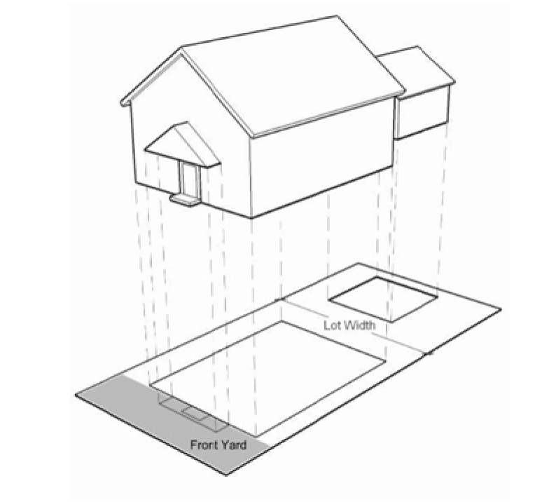
Figure 20.05-1 Detached House
2.
Lot Line (Detached) House
A lot line house is a principal residential building containing one dwelling unit located on a single parcel that is not attached to any other dwelling units. The building is shifted to one side of the parcel so that there is a more usable side yard on one side of the house and very little or no private yard on the other side. Lot line houses are subject to the parcel and building standards of 20.05.050 (Table 20.05-3) except
as modified or supplemented by the lot line house standards of 20.40.080. No more than one lot line house may be located on a single parcel.
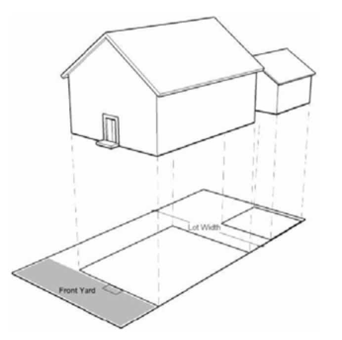
Figure 20.05-2 Lot Line (Detached) House
3.
Townhouse
A residential building containing more than one dwelling unit, each located on its own parcel or TED ownership unit with a common or abutting wall along shared parcel lines or TED ownership unit boundaries. Each dwelling unit has its own external entrance. Townhouses are subject to the parcel and building standards of 20.05.050 (Table 20.05-3) except
as modified or supplemented by the townhouse standards of 20.40.140. No more than one dwelling unit may be located on a single parcel or TED ownership unit. There are two types of townhouses: two-unit townhouses and three+-unit townhouses.
a.
A two-unit townhouse is a townhouse building containing no more than two dwelling units.
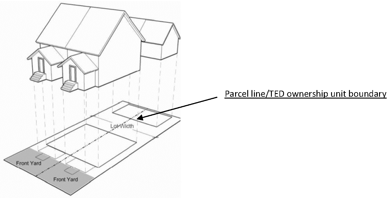
Figure 20.05-3 Two-Unit Townhouse
b.
A three+-unit townhouse is a townhouse building containing three or more dwelling units.
4.
Two-unit House
A two-unit house is a residential building containing two dwelling units, both of which are located on a single parcel (also referred to as a "duplex" or "two-flat"). The dwelling units are attached and may be located on separate floors or side-by-side. Two-unit houses are subject to the parcel and building standards of 20.05.050 (Table 20.05-3). More
than one two-unit house may be located on a single parcel, subject to compliance with all parcel and building standards, including minimum-parcel-area-per-dwelling-unit
and building setback/separation standards and multi-dwelling building standards, (20.40.090.A.2).
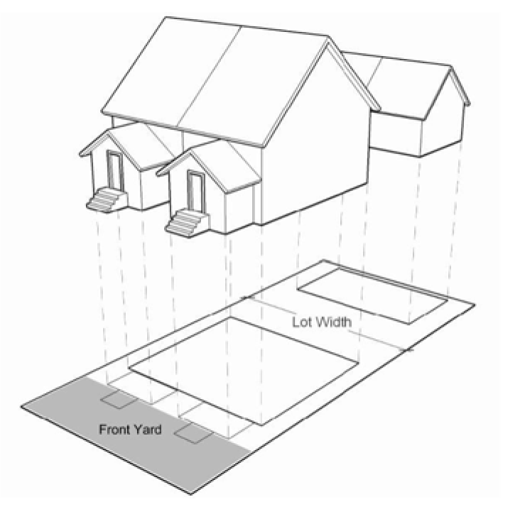
Figure 20.05-4 Two-Unit House
5.
Multi-dwelling House
A multi-dwelling house is a residential building containing three to six dwelling units located on a single parcel. Multi-dwelling houses appear as large detached houses and have only one entrance visible from the street. Multi-dwelling houses are subject to the parcel and building standards of 20.05.050 (Table 20.05-3) except
as modified or supplemented by the multi-dwelling house standards of 20.40.100. More than one multi-dwelling house may be located on a single parcel, subject to compliance with all applicable parcel and building standards.
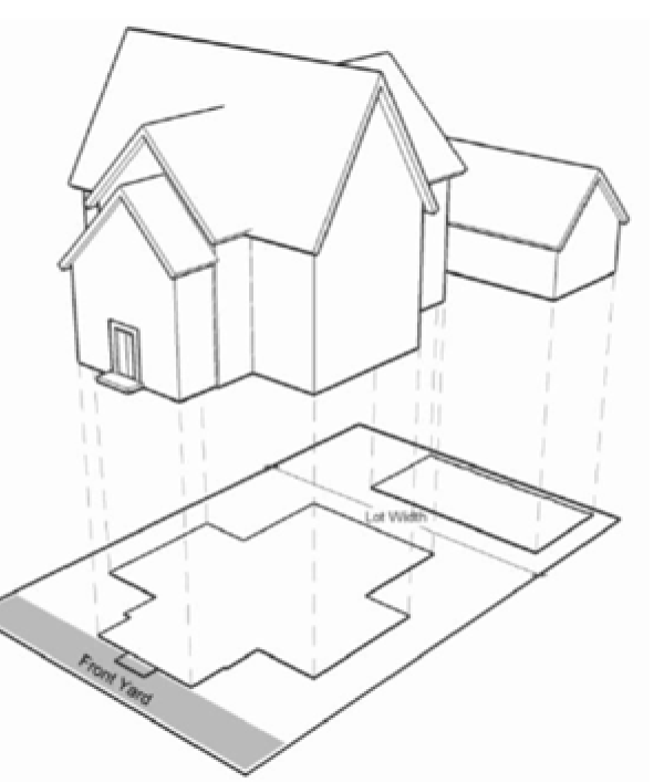
Figure 20.05-5 Multi-dwelling House
6.
Multi-dwelling Building
A multi-dwelling building is a residential building containing three or more dwellingunits (other than a multi-dwelling house) that share common walls and/or common floors/ceilings. Multi-dwelling buildings are typically served by more than one common building entrance. Multi-dwelling buildings are subject to the parcel and building standards of 20.05.050 (Table 20.05-3) except
as modified or supplemented by the multi-dwelling building standards of 20.40.100. More than one multi-dwelling building may be located on a single parcel, subject to compliance with all applicable parcel and building standards.
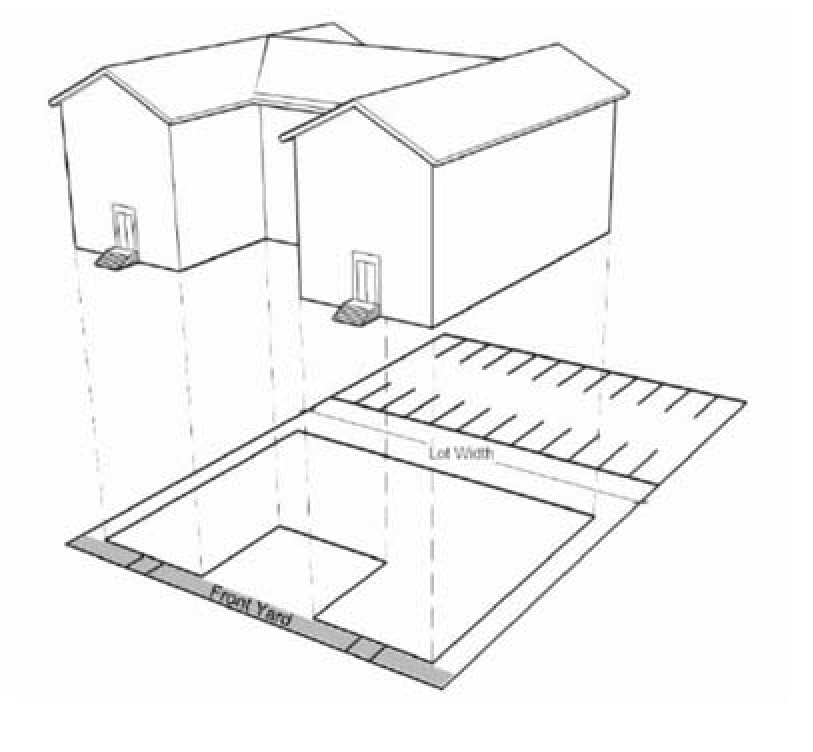
Figure 20.05-6 Multi-dwelling Building
(Ord. 3609, 2018; Ord. 3586, 2016; Ord. 3483, 2012; Ord. 3439, 2010; Ord. 3410, 2009)
20.05.040 - Development Options
Different development options are offered in many of the R districts as a way of promoting a wide variety of community and lifestyle choices and to promote conservation of natural resources, including agricultural lands. Not all development options are allowed in all districts (see Table 20.05-3 to determine which options are allowed in each district). Where allowed, the development options described in this section may be used at the property owner's election.
A.
Conventional Development
"Conventional development" is any development that is not part of an approved cluster development or conservation development.
Parcel and building standards for conventional development can be found in 20.05.050 (Table
20.05-3).
B.
Cluster and Conservation Development
1.
Intent
The cluster and conservation development options are intended to encourage development
designs—whether approved through the subdivision plat, condominium plat or planned
unit development review process—that are more efficient and provide more open space
and greater natural resource protection than conventional development designs. Cluster
development and conservation development designs allow more compact and less costly
networks of roads and utilities. They can also help reduce stormwater runoff and non-point source pollutant loading rates and can be used to preserve an area's
semi-rural character. Cluster developments and conservation developments are intended
to reduce stormwater runoff and flooding, preserve natural resources, protect water quality and encourage the
provision of needed open space and recreational amenities for residents.
2.
General Description
a.
The cluster development and conservation development standards of this chapter require that a specified portion of each development be set aside and permanently preserved as open space.
b.
The primary difference between "cluster" developments and "conservation" developments is the amount of open space that must be preserved.
c.
Cluster and conservation developments must be reviewed in accordance with the city's subdivision plat, condominium plat or planned unit development review process.
d.
Additional information on cluster and conservation development can be found in Chapter 20.55.
3.
Cluster Development
The cluster development option is available in the R215, R80, R40, R20 and RT10 districts.
It allows smaller parcels and other flexible parcel and building standards in exchange for the provision of
common open space that is not typically provided in a conventional development. Parcel and building standards for cluster development can be found in 20.05.050 (Table 20.05-3).
Additional cluster development standards are included in Chapter 20.55.
4.
Conservation Development
The conservation development option is available in the R215, R80, R40, and R20 districts.
It requires more common open space than the cluster development option. In return,
the conservation development option allows the flexibility offered by the cluster
development option and a moderate density bonus (approximately 20%). Parcel and building standards for conservation development can be found in 20.05.050 (Table
20.05-3). Additional conservation development standards are included in Chapter 20.55.
C.
Permanently Affordable Development (three or more dwelling unit project)
The permanently affordable development option is available in the RM2.7, RM1.5, RM1-45,
RM1-35, RMH, RM0.5, B, C, and M1R districts. It allows smaller parcel size and other
modified building standards in exchange for up to 50% (based on an adjusted ratio
scale) of the project developed as permanently affordable for residents who income
qualify, the permanently affordable development option allows a moderate density bonus
based on an adjusted ratio scale, see table below. Parcel and building standards for permanently affordable development can be found in 20.05.050 (Table 20.05-3), 20.10.030 (Table 20.10-2) and 20.15.040
(Table 20.15-2).
1.
Adjusted ratio scale:
D.
Townhome Exemption Development (TED)
1.
Intent
a.
The Townhome Exemption Development Option (TED) is intended to encourage affordable fee simple detached house, two-unit townhouse, and 3+-unit townhousedevelopment without subdivision review in accordance with City zoning regulations.
b.
The Townhome Exemption Development tool is intended to encourage residential development in the city's core in concert with the City of Missoula's stated policy goals, including the development of compact and walkable neighborhoods; the effective use of existing infrastructure, and the building of new, affordable housing in a timely manner.
c.
The administrative TED review is not intended for new greenfield development if it is in an area that is lacking in existing infrastructure; or for sites that would jeopardize the City's ability to manage development in an orderly manner or protect and promote the general health, safety and welfare of the community.
2.
General Description
a.
The only permitted building types that may be included in a TED project are detached houses, two-unit townhouses, and 3+-unit townhouses as described in Section 20.05.030 and as allowed within the applicable zoning district. TED is not permitted for development that includes nonresidential uses.
b.
Two-unit townhouse and 3+-unit townhouse building types as part of TED projects must also comply with Section 20.40.140, Townhouse standards.
c.
TED projects must comply with Section 20.40.180, Townhome Exemption Development (TED) Standards.
d.
Townhome Exemption Developments must meet all applicable City Municipal regulations (see Figure 20.05-7).
Figure 20.05-7 Townhome Exemption DevelopmentRequirements
3.
Condominium Conversion to Townhome
Conversion of condominium projects constructed prior to May 18, 2016, to Townhome Exemption Development (TED) are not subject to the provisions of TED regulations unless dwelling units are added.
(Ord. 3769, 2025; Ord. 3735, 2024; Ord. 3733, 2024; Ord. 3723, 2023; Ord. 3669, 2020; Ord. 3648, 2019; Ord. 3609, 2018; Ord. 3570, 2016; Ord. 3442, 2010; Ord. 3439, 2010; Ord. 3410, 2009)
20.05.050 - Parcel and Building Standards
A.
General
This section establishes basic parcel and building standards for all development in R districts. The standards that apply may vary based on the zoning classification,
building type and development type. These standards are not to be interpreted as a
guarantee that allowed densities and development yields can be achieved on every parcel. Other factors, such as off-street parking requirements, central water and wastewater
service availability, and other factors may work to further limit development potential
on some sites.
B.
Basic Standards
All residential and nonresidential development in R districts must comply with the parcel and building standards of Table 20.05-3,
except as otherwise expressly provided. Nonresidential development in R districts must comply with the "conventional" development standards of Table
20.05-3. General exceptions to parcel and building standards and rules for measuring
compliance can be found in Chapter 20.110.
Commentary: Existing parcels and buildings are subject to the conventional development standards, below. Only new developments that comply with the cluster/conservation development standards listed below and in Chapter 20.55 are eligible to use the following cluster or conservation standards.
Table 20.05-3 Parceland Building Standards (Residential Districts)
[1] RMH standards do not apply to manufactured housing parks. Manufactured housing parks are subject to Title 16.
[2] In a cluster or conservation development, when a contiguous set of parcels is served by a rear alley and no building line has been established by existing buildings on the subject block face, the minimum front setback requirement is 10 feet.
[3] Combined total front and rear setback depths must equal at least 30 feet (e.g., 10' front and 20' rear or 15' each).
[4] Maximum height limit is 30 feet for buildings with primary roof pitch of less than 8 in 12 and 35 feet for buildings with primary roof pitch of 8 in 12 or greater.
[5] Only applies per Section 20.05.040.C.
[6] Area per unit calculation may include a density bonus up to 20%, as shown in the table above, when a project meets the criteria in Section 20.05.040.C. Different area per unit calculations apply for lower density bonuses.
[7] The minimum parcel area requirement does not apply to lots created through subdivisions approved under MCA § 76-3, parts 5 and 6 after May 6, 2019. Total unit yield is calculated based upon the gross parcel area divided by the minimum parcel area per unit and any applicable hillside density reductions.
[8] When the area per unit calculation for the subject parcel is at least 95% of what would be required for one more unit than the calculation allows, that additional unit is permitted.
(Ord. 3735, 2024; Ord. 3648, 2019; Ord. 3609, 2018; Ord. 3586, 2016; Ord. 3570, 2016; Ord. 3442, 2010; Ord. 3439, 2010; Ord. 3410, 2009)
20.05.060 - Other Regulations
Uses and development in R districts may be subject to other provisions of this zoning ordinance, including the following:
A.
Overlay Districts
See Chapter 20.25.
B.
Use and Building Specific Standards
See Chapter 20.40.140 for Townhouse Development Standards.
See Chapter 20.40.180 for Townhome Exemption Development (TED) Standards.
C.
Accessory Usesand Structures
(e.g., home occupations, detached garages, gazebos, and sheds) See Chapter 20.45.
D.
Natural Resource Protection
See Chapter 20.50.
E.
Parking and Access
See Chapter 20.60.
F.
Landscaping
See Chapter 20.65.
G.
Signs
See Chapter 20.75.
H.
Nonconformities
See Chapter 20.80.
1.
RM2.7 District
a.
Expansion of Existing Commercial and Industrial Uses
Any commercial or industrial use lawfully established in the RM2.7 district before November 4, 2009 may be expanded if the (conventional
development) parcel and building standards of 20.05.050, the parking and access standards of Chapter 20.60, and the landscaping standards of Chapter 20.65 are met.
b.
Substitution of Commercial and Industrial Uses
Any commercial or industrial use lawfully established in the RM2.7 district may be replaced by a use of similar or less intensity. If a
less intensive use is established, the use may not later revert back to the previous
intensity.
c.
Replacement of Commercial and Industrial Buildings
Any commercial or industrial buildinglawfully established in the RM2.7 district before November 4, 2009 may be replaced or expanded if the
(conventional development) parcel and building standards of 20.05.050, the parking and access standards of Chapter 20.60, and the landscaping standards of Chapter 20.65 are met.
d.
New Commercial and Industrial Uses
Except as expressly allowed by this zoning ordinance, no additional parcels may be committed to commercial or industrial use in the RM2.7 district and no more
intensive commercial or industrial use may be established after November 4, 2009.
(Ord. 3648, 2019; Ord. 3439, 2010; Ord. 3410, 2009)