Salisbury City Zoning Code
CHAPTER 17
100 - PALEOCHANNEL AND WELLHEAD PROTECTION DISTRICTS*
17.100.010 - Purpose.
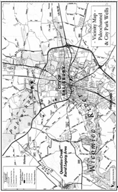
The paleochannel is an ancient buried underground riverbed with approximately seven billion (7,000,000,000) gallons of water, which extends into the northerly portion of Wicomico County from Dorchester County and which has been nominated by the city council and designated as an area of critical state concern by the Maryland Department of State Planning. The paleochannel extends into Salisbury along its northerly corporate limits, has been mapped and studied in its known portion by the Maryland Geological Survey, provides potable water for the City of Salisbury and is a potentially unlimited source of water for both Salisbury and Wicomico County. Because of its vast potential as a potable abundant water supply, protective measures, in the form of use limitations and review procedures, are necessary to ensure that it is protected from contamination while continual study is done of the paleochannel's recharge areas and its capabilities and limitations. The following district, uses and development standards have been developed based upon this purpose, which is in accord with the findings and recommendations for the paleochannel in the city's adopted metro core comprehensive plan.
In addition to two wells located in the paleochannel (known as the "paleo wells"), the City of Salisbury has nine wells located along the banks of the South Prong of the Wicomico River (Beaverdam Creek) from which potable water is obtained. These wells are known as the "park wells."*
(Ord. 1912 (part), 2004)
* Editor's Note: A map of the Salisbury paleochannel is included at the end of this chapter.
17.100.020 - Establishment of boundaries.
The paleochannel district shall be shown on the official zoning map as a district overlying the existing zoning and shall include all that area within the Salisbury corporate limits shown on the Maryland Geological Survey Map for the paleochannel set forth in Bulletin 31, Part II, by James W. Weigle, 1972, and may be changed from time to time as the paleochannel is further defined without the necessity of showing a mistake in the original boundaries or a change in the neighborhood.
The boundaries of the wellhead protection district shall be shown on the official zoning map as a district overlying the existing zoning and shall include all that area within Salisbury's corporate limits mapped by the Maryland Department of the Environment, included in the source water assessment study and dated January, 2003. These boundaries may be changed from time to time as data is updated for the wellhead protection areas without the necessity of showing a mistake in the original boundaries or a change in the neighborhood.
(Ord. 1912 (part), 2004)
17.100.030 - Permitted and accessory uses.
Permitted uses and accessory uses shall be as follows:
A.
All uses permitted in the underlying zoning district(s), with the following exceptions:
1.
Uses which discharge excessive amounts of water or use, store or generate raw or waste materials which are ignitable, corrosive, reactive or toxic, such as, but not limited to, manufacture of organic and inorganic chemicals, paint and pigments, petroleum refining, steel, metal products fabrication, electroplating and textile dyeing and finishing.
(Ord. 1912 (part), 2004)
17.100.040 - Development standards.
In addition to the development standards for the underlying zoning district(s), the following shall be required:
A.
All proposals for development of any lot or parcel of land for any use within the paleochannel or wellhead protection districts shall require submission of a comprehensive site plan to be reviewed by the planning commission.
B.
The planning commission shall review the proposal relative to any existing or future possibility of contamination of the paleochannel or wellheads through storage and handling of raw and waste materials or from the particular manufacturing or industrial process proposed. The commission shall solicit any technical advice or information it deems necessary in its review of the proposed use to assure that possible contamination will not occur, including, but not limited to, the following:
1.
A copy of all necessary permits from the Maryland Department of Water Resources and any other applicable state agency;
2.
An impact statement from an independent consultant, at the developer's expense.
C.
If the commission is satisfied that the proposal poses no unacceptable risk of contamination to the paleochannel or wellheads, the comprehensive site plan may be approved.
D.
If the commission determines that there is any possibility that the proposal may pose an unacceptable risk of contamination to the paleochannel or wellheads, then the request to construct or use and operate such use at the proposed location shall be denied.
E.
A proposal which has been rejected by the commission may be resubmitted for review if there has been a major change in the processing, storage or handling of material which eliminates the potential risk of contamination to the paleochannel or wellheads.
F.
Appeal from the commission's final decision may be made to the circuit court for Wicomico County within thirty (30) days of the commission's final decision.
G.
Uses operating or described in Section 17.100.030(A)(1) existing at the date of amendment of this chapter and located in the paleochannel or wellhead districts shall submit a plan for management of materials which may pose a risk of contamination to the paleochannel or wellheads. Submission review and approval of the plan shall follow the same procedure as required for new uses, except that the required comprehensive site plan shall be at the discretion of the planning director.
(Ord. 1912 (part), 2004)