Salisbury City Zoning Code
CHAPTER 17
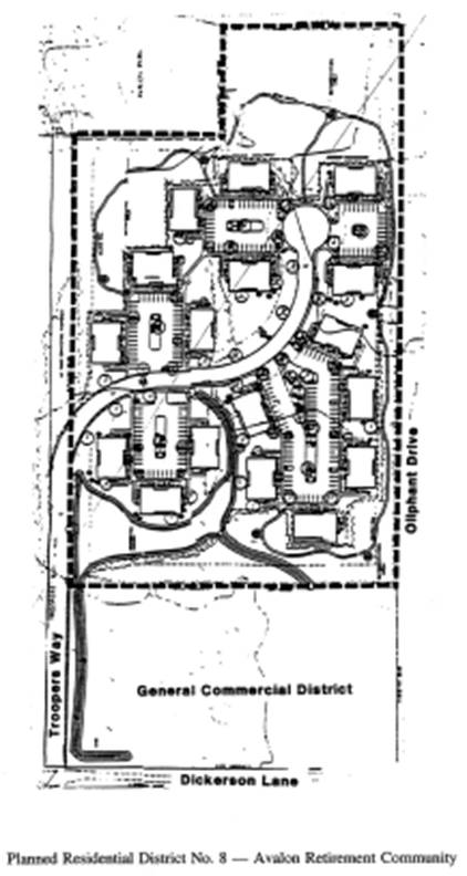
151 - PLANNED RESIDENTIAL DISTRICT NO. 8—AVALON RETIREMENT COMMUNITY
17.151.010 - Purpose.
The purpose of planned residential development No. 8* is to provide for the development of certain lands east of Dickerson Lane, binding upon the north side of Oliphant Drive and the south side of Troopers Way, as a retirement community consisting of one hundred two (102) apartment units. The development is designed in a manner that will provide perimeter setbacks and forested open spaces that will provide future natural buffers from adjoining residential and commercial development.
The following regulations have been designed to carry out these purposes and are further implemented in the approved preliminary development site plan and approved development standards plan dated May 21, 1996.
(Ord. 1639 (part), 1996)
* Editor's Note: The planned residential district No. 8 Map is included at the end of this chapter.
17.151.020 - Area of reclassification.
The area to be rezoned as planned residential district No. 8—Avalon Retirement Community, consists of 14.47 acres now or formerly owned by Commercial Investment Partnership situated in the Parsonsburg election district in the City of Salisbury, Maryland. The site is bounded on the north by Troopers Way (formerly Shockley Drive), on the east by Avalon Park subdivision, on the south by Oliphant Drive (unimproved) and on the west by other lands of Commercial Investment Partnership. The property of the rezoning site is shown on Assessment Map No. 20 as part of Parcel No. 177 and is more specifically defined on a preliminary development plan approved by the Salisbury-Wicomico County planning and zoning commission on June 20, 1996 as attached hereto and made a part hereof.
(Ord. 1639 (part), 1996)
17.151.030 - Permitted uses.
Permitted uses shall be as follows:
A.
Apartments;
B.
Townhouses;
C.
Duplex;
D.
Multifamily units;
E.
Single-family detached.
(Ord. 1639 (part), 1996)
17.151.040 - Accessory uses and structures.
Accessory uses and structures shall be as follows:
A.
Accessory uses and structures clearly incidental to, customary to, and associated with the permitted use.
(Ord. 1639 (part), 1996)
17.151.050 - Development standards.
Development standards for planned residential district No. 8 shall be as follows:
A.
Minimum Lot or Building Area Requirements.
1.
Fourteen and forty-seven hundredths (14.47) acres as shown on the approved and recorded final development plan.
B.
Minimum Setback Requirements.
1.
Minimum perimeter setback for all buildings and structures shall be forty (40) feet from the property line as shown on the approved and recorded final development plan.
2.
Minimum building setback from the right-of-way of Troopers Way shall be thirty (30) feet as shown on the approved and recorded final development plan.
3.
All other setbacks shall be as shown on the final development plan.
C.
Density requirements shall be as follows:
1.
Not more than seven units per acre.
D.
Height requirements shall be as follows:
1.
Thirty-five (35) feet.
E.
Parking requirements shall be as follows:
1.
One and one-half parking spaces per unit, plus twenty (20) percent for guest parking.
F.
Landscaping. Landscaping shall be in accordance with the final landscaping plan as approved by the planning commission.
G.
Signs shall be in accordance with Section 17.216.070.
(Ord. 1639 (part), 1996)
17.151.060 - Street standards.
A.
Accessways and streets shall be provided as shown on the final development plan.
B.
Troopers Way shall be developed in accordance with city street standards.
C.
In the event that all property owners abutting the remaining unimproved right-of-way of Troopers Way extending easterly to the Avalon Park subdivision agree to close this portion of the right-of-way, the developers will also agree to close its portion of the right-of-way as well.
(Ord. 1639 (part), 1996)
17.151.070 - Amendments.
Amendments to planned residential district No. 8 shall be in accordance with the procedures established in Chapters 17.112, 17.204 and 17.228.
(Ord. 1639 (part), 1996)
17.151.080 - Final development plan.
A final development plan shall be prepared, submitted to, and approved by the Salisbury planning commission in accordance with Section 17.204.070.
(Ord. 1639 (part), 1996)
17.151.090 - Control of development during construction and after completion.
Once the preliminary development plan and all related development controls are adopted by the city council, development of the area shall be controlled by the final development plan as approved by the Salisbury planning commission and recorded in the land records of Wicomico County and any amendments thereto. Where specific regulations are not addressed in this district, all other regulations of this chapter shall govern.
(Ord. 1639 (part), 1996)