Salisbury City Zoning Code
CHAPTER 17
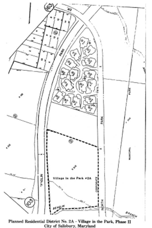
124 - PLANNED RESIDENTIAL DISTRICT NO. 2A—VILLAGE IN THE PARK, PHASE II
17.124.010 - Purpose.
The purpose of planned residential district No. 2A is to provide for the development of a parcel of land fronting on Beaglin Park Drive and North Park Drive with sixteen (16) one-story units in a cluster-type development which retains approximately sixty-one and six-tenths (61.6) percent of the site in open space, negative traffic impact on Beaglin Park Drive through development design with no entrances or access from Beaglin Park Drive, a reduced public utility network and no public street maintenance through provision of private, on-site access drives. The following regulations are based on these purposes and the approved preliminary development plan and preliminary subdivision plat, which are in accordance with the zoning recommendations of the metro core comprehensive plan.*
(Prior code § 150-165.45)
Editor's note— The planned residential district No. 2A—Village in the Park, Phase II, map is included at the end of the chapter.
17.124.020 - Area of reclassification.
The area to be rezoned as planned residential district No. 2A—Village in the Park, Phase II, consists of five and one-hundredths (5.01) acres of land situated in the Parsons Election District, in the City of Salisbury, on the westerly side of and binding upon Beaglin Park Drive and on the easterly side of and binding upon North Park Drive; adjoining the land now or formerly owned by Keith E. Rinehart on the south, and the Beaglin Branch on the north. The site is shown on Assessment Map No. 38 as Parcel 310 and is more specifically defined on the preliminary subdivision plat prepared by Hampshire, Hampshire and Andrews, dated March 31, 1988, and approved by the planning commission on May 19, 1988.
(Prior code § 150-165.46)
17.124.030 - Permitted uses.
Permitted uses shall be as follows:
A.
Cluster development limited to one-story, one-unit residential structures as illustrated on the final development plan as recorded in the land records of Wicomico County.
(Prior code § 150-165.47)
17.124.040 - Accessory uses and structures.
Accessory uses and structures shall be as follows:
A.
Home occupation;
B.
Home office;
C.
Family day-care home;
D.
Private garages and other accessory uses normally associated with residential use, such as but not limited to detached home workshop, swimming pool, cabana, greenhouse and private studio, all of which shall be incidental to the use of the property as a residence;
E.
Storage of recreational vehicles and boats on individual building areas, limited to two in any combination, in back of the front building setback line, where such recreation vehicles and boats are for use and enjoyment of the residents thereon;
F.
Other accessory uses and structures clearly incidental to, customary to and associated with the permitted use.
(Prior code § 150-165.48)
17.124.050 - Development standards.
Development standards for the planned residential district No. 2A shall be as follows:
A.
Minimum Individually Owned Building Area Requirements.
1.
Each individual building area shall have an average land area of five thousand two hundred thirty and eight-tenths (5,230.8) square feet;
2.
Individual building area lengths and widths shall be as shown on the final development plan and final subdivision plat as approved by the Salisbury planning commission.
B.
Minimum individually owned building area and perimeter setback requirements shall be as follows:
1.
Building area: one foot from all property lines.
2.
Perimeter Building Setbacks.
a.
Twenty (20) feet minimum from curbline on North Park Drive;
b.
Seventeen (17) feet minimum from property line on Beaglin Park Drive;
c.
Twelve (12) feet from southerly property line;
d.
Northerly Property Line. Perimeter setback line shall be the southerly boundary of the natural area as shown on final plan and final subdivision plat.
C.
The height limitation shall be thirty-five (35) feet.
D.
Parking shall be provided in accordance with chapter 17.196. Parking of vehicles of any type shall not be permitted within the front yard other than in driveways providing access from public or private streets. No storage of trucks or vans used in the conduct of a business shall be permitted.
E.
Landscaping. All areas not devoted to building or required parking areas shall be landscaped as defined in Section 17.04.120 and planted and maintained in accordance with chapter 17.220.
F.
Signs. Signs shall be in accordance with chapter 17.216.
(Prior code § 150-165.49)
17.124.060 - Street standards.
The right-of-way for all interior accessways shall be twenty (20) feet and shall provide public access with private maintenance.
(Prior code § 150-165.50)
17.124.070 - Amendments.
Amendments to the planned development district No. 2A shall be in accordance with the procedures established in Chapters 17.204, 17.112 and 17.728.
(Prior code § 150-165.51)
17.124.080 - Final development plan.
A final development plan shall be prepared, submitted and approved by the planning commission in accordance with chapter 17.204, Section 17.204.070.
(Prior code § 150-165.52)
17.124.090 - Control of development during construction and after completion.
Once the preliminary development plan and all related development controls are adopted by the city council, development of the area shall be controlled by the final development plan as approved by the planning commission and recorded in the land records of Wicomico County and any amendments thereto. Where specific regulations are not addressed in this district, all other regulations of Title 17 of the city Code shall govern.
(Prior code § 150-165.53)