
Sandy City Zoning Code
CHAPTER 21
12.- HISTORIC SANDY DEVELOPMENT OVERLAY ZONE
Sec. 21-12-1.- Purpose.
(a)
The Historic Sandy Development (HSD) Overlay Zone is established to provide a floating zone to be used in appropriate locations within Historic Sandy in conjunction with the underlying R-1-7.5(HS) or other residential zones within the defined area and to provide subdivision design incorporating traditional neighborhood standards. Historic Sandy is an area bounded by 9000 South on the south, State Street on the west, 8400 South on the north, and 700 East on the east. The HSD Overlay Zone may not be utilized for properties outside of these defined boundaries. New developments outside of the Historic Sandy area may use the Residential Conservation Overlay Zone as an alternative. The Historic Sandy Development (HSD) Zone represents a departure from typical zoning to the extent that it requires physical design that promotes human scale pedestrian activity (walkability) through the incorporation of specific development guidelines. These guidelines include controlling architectural elements, driveways, walkways, landscaping, street design, and other pedestrian elements.
(b)
The overall desired effect of this zone is to provide a quality living environment that encourages contact between neighbors, provides quality housing for families in various stages of the life cycle, discourages crime (through natural surveillance design), reduces overall vehicle trips, and improves air quality. Proposed developments with increased land intensity and housing density, but without the above walkable elements, are unacceptable in the overlay zone.
(c)
The overlay zone is intended to create efficient usage of land by controlling the intensity of land use, providing sufficient critical mass, and design features to create a walkable neighborhood.
(LDC 2008, § 15A-12-01; Ord. No. 15-35, 11-23-2015; Ord. No. 16-06, 2-5-2016)
Sec. 21-12-2. - Procedures.
(a)
All submissions shall be made well in advance of planned construction for proper coordination and feedback and shall be reviewed by the City Development Committee and/or respective architectural review body before submittal to the Planning Commission.
(b)
Prior to the Planning Commission taking action, plans must be submitted in accordance with the subdivision procedures.
(c)
The Planning Commission will review all HSD proposals. The Planning Commission shall consider potential changes to traffic, parking, pedestrian activity, and other impacts.
(LDC 2008, § 15A-12-02)
Sec. 21-12-3. - Uses Allowed.
(a)
Location Criteria. Historic Sandy developments may be located at infill locations where walkable components (e.g., housing choices, convenience commercial, employment, community facilities, transportation linkages, parks or other open spaces, schools, churches) are already present or planned.
(b)
Ancillary Uses. All permitted and conditional land uses within the HSD Zone may conduct ancillary uses, as specifically defined within Chapter 21-37, provided such use is not regulated by other sections or is listed as a non-permitted land use in the underlying zone district.
(c)
Permitted and Conditional Uses. The Historic Sandy Development (HSD) Zone is an overlay district, and, as such, permitted and conditional uses are governed by the requirements and standards of the specific underlying residential zone. Except as otherwise stipulated in the HSD Zone, development proposals shall comply with the requirements of the underlying zone.
(LDC 2008, § 15A-12-03)
Sec. 21-12-4. - Lot and Building Placement/Design Requirements.
The following standards are to be considered as applying specifically to development in the HSD Zone in addition to general standards elsewhere in this title:
(1)
Historic Sandy Development Plan. Regardless of the size and ownership of individual parcels, a development plan must be submitted showing both existing and reasonable projected development on adjoining properties, determined through consultation with adjoining property owners. The intent is to achieve an overall walkable neighborhood development with appropriate pedestrian connections, cross-easements, common driveways, consistent site standards, etc., even though properties may be individually owned.
(2)
Parcel Size. Parcels shall be of sufficient size to assure compliance with building setbacks, landscaping, access, off-street parking requirements, and walkability standards based upon the following minimum standards:
Minimum Parcel Size and Setback Minimum Requirements
*The side yard setbacks as shown is the minimum for one side and a total for both sides.
(3)
Housing Types. A blend of housing types such as single-family, twin home, and town homes may be determined by the Planning Commission depending upon the existing adjacent neighborhood, size, scale, and location of the property. Lot sizes and lot frontages may be modified by the Planning Commission for town home buildings not exceeding four units or twin homes. Zero lot line or common wall construction for town homes and twin homes may be considered based upon subdivision layout design.
(4)
Multifamily Standards.
a.
Twin home or town home developments may be considered in three different areas within Historic Sandy (as shown in the Historic Sandy Neighborhood Plan).
1.
One block south and approximately 350 feet north of Main Street.
2.
One block west and approximately 500 feet east of the TRAX corridor, not extending north of 8680 South Street.
3.
Between 8680 South and 8770 South 620 East.
b.
If approved by the Planning Commission, any twin home or town home development that has enough public frontage that could provide at least one on-street parking space for each unit may be allowed to build single-car garages.
c.
All twin home or town home developments must be rear loaded.
(5)
Building Placement.
a.
Building Orientation. The entrances of all dwellings shall front onto public streets or open space with entrance sidewalks directly accessing the street sidewalk. On a case-by-case basis, a limited number of dwelling units, attached or unattached, fronting onto a private driveway may be approved, as deemed appropriate by the Planning Commission, depending on the size, scale, design, location, topography, or other natural features associated with the property.
b.
Building Height. Dwelling structures shall comply with the height requirements of the underlying residential district.
(6)
CPTED (Crime Prevention Through Environmental Design). Where practically possible, CPTED principles shall be used in the design and layout of buildings, streets, accesses, landscaping, and open space areas.
a.
Design shall promote natural surveillance, access control, territorial reinforcement, sense of ownership, and maintenance. CPTED landscaping guidelines shall be used, including planting shrubs with a maximum height of two to three feet at full maturity, and trees with a ground clearance of eight feet at full maturity above walkways and sidewalks, and 14 feet at full maturity above vehicular travel and parking lanes.
b.
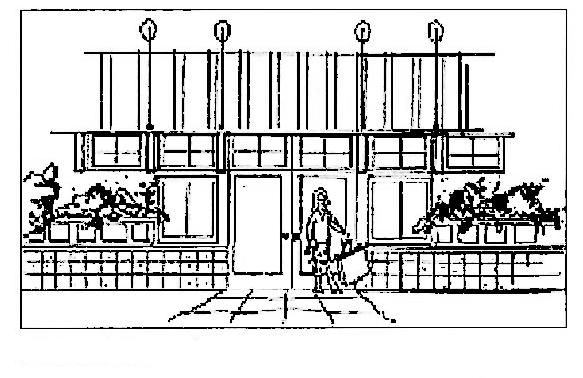
In order to encourage public safety through natural surveillance, natural access control, and territorial reinforcement, blank walls are not permitted adjacent to streets, pedestrian areas, and open space amenities. Developments shall have street side dwelling elevations with extensive windows with balconies, decks or landscape terraces being encouraged. Symbolic barriers, such as low lying fences/walls and landscaping, shall be used to discourage crime and promote safety.
c.
Fences or walls, if desired by the applicant, must be reviewed for their effectiveness in protecting private space while not creating isolated uses or dead space void of natural surveillance. Approved fences or walls shall be compatible in color, texture, and design in relationship to building materials. Landscape buffers are preferred over fences and walls where separation is desirable. A visually open look shall be encouraged. Landscape buffers which create outdoor rooms are often more important than a physical separation.
Natural Surveillance
(LDC 2008, § 15A-12-04; Ord. No. 10-26, 7-30-2010; Ord. No. 13-18, 8-22-2013)
Sec. 21-12-5. - Architectural Design and Materials.
(a)
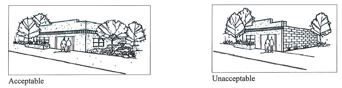
The treatment of buildings, materials, and exterior appurtenances shall create an aesthetically pleasing dwelling and site that is in character with the proportions of other surrounding historic structures, and yet provides diversity in design. An architectural balance of building materials, colors, design features, and textures which create random compatibility shall be sought.
(b)
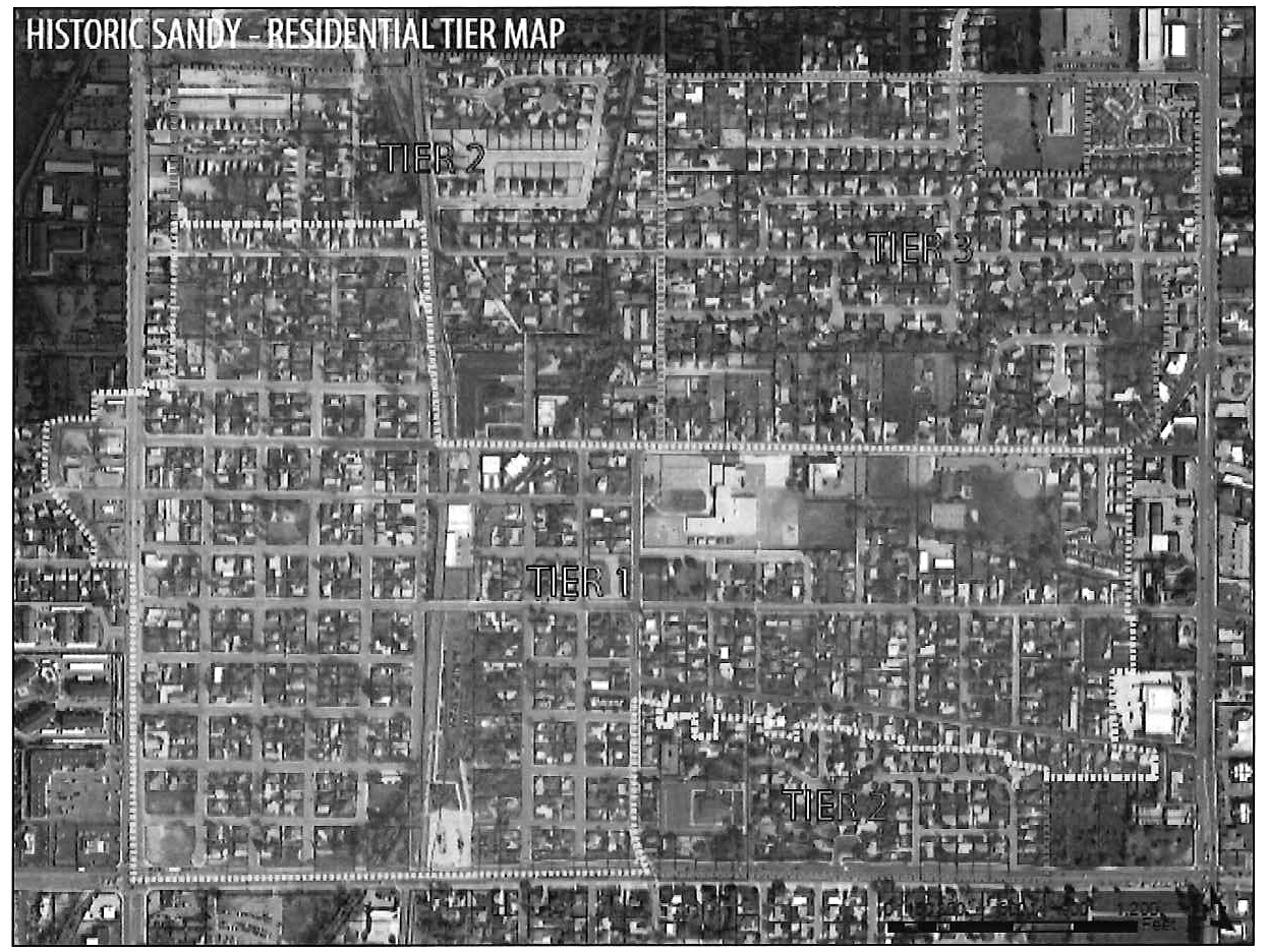
Historic Sandy has a three-tier design system for development which was adopted as part of the Historic Sandy Neighborhood Plan. Tier 1 is characterized by modest homes built in the late 1800s to mid-1900s in the blocks immediately surrounding the original Sandy commercial district, as well as a corridor along Locust Street and 8800 South. Tier 2 consists of a wide variety of residential home types from very early bungalows to modern homes. Tier 3 is an area that has the most typical post-war suburban development pattern. Sensitivity must be shown to better blend into existing historical and non-historical homes.
(c)
These different tiers are identified in the Master Plan and shown below.
(d)
The following requirements are applicable to any new development or a remodel of a contributing structure:
(1)
The Planning Commission shall review and approve building elevations and materials for all projects within a HSD Overlay Zone, particularly where exposed to pedestrian and/or vehicular traffic. For new subdivisions, the developer will be required to create design guidelines for new homes to ensure compatibility with the homes in the area. Considerations for these guidelines may include, but not be limited to, gables, dormers, shutters, other window treatments, street side balconies/decks, and wrap-around porches (particularly on corner lots).
(2)
Basic building materials for all residential uses shall be predominantly one material of brick, stone, or masonry. Limited amounts of stucco and composite or wood siding may be considered if the quality of the design merits such consideration (no vinyl or aluminum siding allowed).
(3)
a.
Tier 1. Architectural materials and elevations shall be reviewed by the Planning Commission, after a recommendation from the Historic Preservation Committee. The elevations and materials must be architecturally compatible with one of the different housing styles (e.g., Colonial, Bungalow, and Craftsman) that may be found within the surrounding area. For all new single-family dwellings built within the Tier 1 neighborhood, the garage must be recessed from the front porch by ten feet or be detached.
b.
Tier 2. Architectural materials and elevation shall be reviewed by the Planning Commission. Any remodel of an existing contributing structure or new developments within 200 feet of a contributing structure on the same street must first be reviewed by the Historic Preservation Committee (as identified on the latest reconnaissance survey on file with the Community Development Department). If this is the case, then elevations and materials must be architecturally compatible with one of the different housing styles (e.g., Colonial, Bungalow, and Craftsman) that may be found on the same street.
c.
Tier 3. Architectural materials and elevation shall be reviewed by the Planning Commission. Any remodel of an existing contributing structure or new developments within 100 feet of a contributing structure on the same street must first be reviewed by the Historic Preservation Committee (as identified on the latest reconnaissance survey on file with the Community Development Department). If this is the case, then elevations and materials must be architecturally compatible with one of the different housing styles (e.g., Colonial, Bungalow, and Craftsman) that may be found on the same street.
(4)
Buildings shall be designed to relate to grade conditions with a minimum of grading and exposed foundation walls, creating easy pedestrian access from sidewalks, parking areas, etc.
(LDC 2008, § 15A-12-05)
Sec. 21-12-6. - Landscaping.
Front yard landscaping is required to be installed by the developer. If open space and other common areas are provided in the development, these areas may be required to be landscaped by the developer. Guidelines for required landscaping are established to improve and then maintain site qualities while minimizing alteration, removal, or degradation of approved and installed landscaping. Landscaping shall follow CPTED principles and the Section 21-25-4.
(1)
When landscaping is required, no plans for any building, structure or other improvements shall be approved unless a satisfactory Landscape and Streetscape Plan has also been submitted and approved.
(2)
Landscaping in accordance with the approved plans must be installed within 30 days following the occupancy of the site or as otherwise approved by the City as seasonal conditions may suggest.
(3)
The land area not occupied by buildings, structures, hard surfacing, vehicular driveways, or pedestrian walkways shall be kept clear of weeds or landscaped.
(4)
The developer shall submit a guarantee for public landscaping improvements to ensure that installations are completed as submitted and approved.
(5)
The developer shall install the following:
a.
On-Site Trees and Shrubs. In addition to the required street trees, a minimum of one evergreen tree (six feet minimum) is required for each home. A variety of shrubs and flower beds shall also be provided for each home.
b.
Street Trees.
1.
A minimum two-inch caliper street trees as measured six inches above grade shall be installed by the developer/builder located between the curb and sidewalk along all rights-of-way. In order to facilitate the planting of street trees, an eight-foot parkstrip and five-foot sidewalk is the standard requirement. Reduced parkstrip and sidewalk width may be approved based upon size, scale, and nature of the project and the type of existing improvements on adjacent properties. However, a ten-foot cross-section (five foot parkstrip, five foot sidewalk) is the minimum and may necessitate tree planting behind the sidewalk.
2.
The species type, location, and spacing of trees shall be shown on the approved Landscape Plan and be in compliance with designated streets within the City's Streetscape Plan. For streets not specified in the Streetscape Plan, the Planning Division may recommend different trees that would be appropriate for the area.
c.
Installation. It shall be the responsibility of the developer/builder to grade, place topsoil, seed, sod, install sprinkler irrigation systems, and properly plant trees, shrubs, and other approved plant materials.
d.
Maintenance. It shall be the responsibility of the developer, property owner and/or property association to properly maintain landscaped areas, including watering, mowing, pruning, fertilizing, and the removal and replacement of dead plant materials in a timely manner.
(LDC 2008, § 15A-12-06; Ord. No. 23-08, § 1(Exh. A), 7-18-2023)
Sec. 21-12-7. - Outdoor Lighting.
(a)
The lighting of streets, pedestrian areas, parking lots, and open space is required. Exterior wall-mounted floodlights must be directed downward to avoid light spill on adjacent property. Indirect lighting, bollard lighting, and landscape lighting is encouraged.
(b)
The amount and type of lighting will be evaluated on how adequately it meets its intended purpose. Design and location of standards and fixtures shall be specified on the site development drawings. Intensities shall be controlled so that safety lighting is provided while neighboring areas are protected from glare or excessive direct light. Street light design fixtures shall be installed as required by the street lighting policy.
(LDC 2008, § 15A-12-07)
Sec. 21-12-8. - Streets and Pedestrian Ways.
(a)
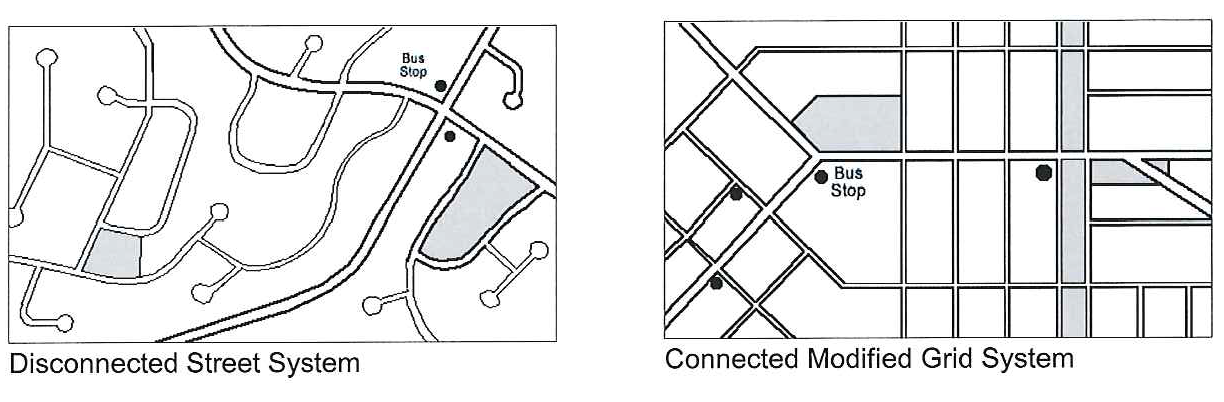
Streets. All accesses within a HSD shall have connectivity with existing and future street patterns. A grid street pattern or modified grid pattern is required where practically possible. Cul-de-sac streets will not be approved unless it can be demonstrated that no other practical way exists to provide connectivity. In order to uphold and enhance HSD principles, private streets are highly discouraged and gated communities are prohibited.
(b)
Widths. Street widths shall be determined during site plan review as may be recommended by the City Transportation Engineer and approved by the Planning Commission. In general, streets shall be designed to meet the level of travel and service while incorporating principles of traffic calming and pedestrian compatibility (e.g., tree lined streets with pedestrian ways and linkages, decreasing the need for pavement width by spreading traffic through a grid, or modified street hierarchy system).
(c)
Sidewalks and Walkways. The design of pedestrian ways may include a solitary meandering pathway or trail or other possible designs as may be approved by the Planning Commission. Choice of appropriate pedestrian access will be made based upon the scale and type of the HSD project being proposed.
(d)
Pedestrian Connections. Crosswalks shall be incorporated within the project, at intersections, within parking lots, or other needed pedestrian connections as approved by the Transportation Engineer. Crosswalks shall be so configured to be a design feature of the development (e.g., heavy painted lines, pavers, edges, and other methods of emphasizing pedestrian use). Bulb-outs and other pedestrian designs may be used to shorten walking distances across open pavement. Medians may be used in appropriate areas to encourage walking and to act as a refuge for crossing pedestrians.
(LDC 2008, § 15A-12-08)
Sec. 21-12-9. - Other Forms of Transportation.
All forms of transportation shall be considered within and without the HSD with the intent to improve convenience and reduce vehicle trips. All forms of transportation should be encouraged, including bus, bicycle, and pedestrian. Access connections may be required when deemed essential to provide circulation or access to churches, schools, playgrounds, shopping centers, transportation, and other community facilities. This is subject to review and recommendation by City staff, including Parks and Recreation, Planning, and Police Departments, and the City Transportation Engineer.
(LDC 2008, § 15A-12-09)
Sec. 21-12-10. - Environmental Concerns.
(a)
Building, landscape, and solar design should be adjusted, where possible, to be compatible with the local climate. Such design should include, but may not be limited to, window placement, building recesses, overhangs, trellises, awnings, porches, and landscape placement planned in such a way to enhance livability and reduce energy costs.
(b)
The use of lighter colored building materials for roof tops and fences/walls, and extensive deciduous and evergreen tree cover shall be incorporated into developments in order to reduce the urban heat island effect. Where possible, streets, driveways, parking areas, etc., should use concrete or other materials that absorb less sunlight.
(c)
Where possible, drought-resistant ground covers, shrubs, and trees shall be incorporated into the landscape to reduce water usage and storm runoff. Extensive areas of grass or other high water use plants are discouraged. Compliance with Section 21-25-4 is required.
(LDC 2008, § 15A-12-10)
Sec. 21-12-11. - Special Requirements Applicable to the HSD Overlay District.
The following HSD design elements shall be required:
(1)
Depending on the location, size, and scale of the project, a mix of housing types shall be employed (e.g., single-family detached, twin homes, town homes, etc.).
(2)
Where practical, the same land uses and housing types shall front each other or shall front open space.
(3)
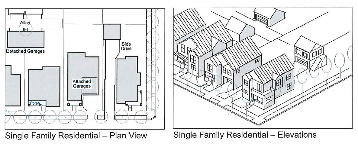
Subservient garages (e.g., back loaded detached with alley access, front loaded detached, attached, side entry attached, or a combination of the above). The garage shall not exceed 50 percent of the front elevation. The garage must be recessed from the front porch by at least five feet, except in Tier 1, where a ten foot setback or a detached garage is required. Three-car garages are not permitted within Tier 1, and in portions of the Tier 2 (west of the railroad) neighborhoods.
(4)
Roofs with a five-twelfths pitch or greater.
(5)
Dwelling and garage gables facing streets and alleys.
(6)
Covered and open front porches comprising at least 50 percent of the front elevation (not including the garage), in no case being less than 15 feet in length.
(7)
Entry (porch) sidewalks that connect directly to street sidewalks.
(8)
Windows and doors are required to occupy at least 25 percent of the front elevation.
(9)
Dwelling footprints shall not occupy more than 50 percent of the lot, except in the following circumstances:
a.
The home is within Tier 2 (east of the railroad) and Tier 3 neighborhoods;
b.
The lot has at least 7,500 square feet; and
c.
The home has a three-car garage, in which case the footprint shall not occupy more than 65 percent of the lots.
(10)
Primary entrance to the home shall be from a public street, unless a flag lot is approved by the Planning Commission.
(LDC 2008, § 15A-12-11)
Sec. 21-12-12. - Utilities in Historic Sandy Developments.
All utility lines shall be underground in designated easements. No pipe, conduit, cable, line for water, gas, sewage, drainage, steam, electricity, or any other energy or service shall be installed or maintained upon any lot (outside of any building) above the surface of the ground except for hoses, movable pipes used for irrigation or other purpose during construction.
(1)
Transformers shall be grouped with other utility meters where possible and screened with vegetation or other appropriate method. Placement of transformers in front setback locations, particularly on corners, is to be avoided.
(2)
Each contractor and owner/developer shall be responsible to know the location of all underground utilities. Protection of such utilities shall also be their responsibility. Prior to construction, contact must be made with "Blue Stakes" to identify underground utility lines.
(3)
Actual tree spacing during site plan review may be adjusted as necessary to match existing streetscape or to adapt to unique on-site conditions that would justify such (e.g., topography, street lights, power lines and poles, and other utilities). In some cases, street trees may need to be relocated in order to accommodate on-site conditions. Parkstrips on arterial and collector streets should accommodate street trees, street lights, and other needed utilities. Street trees should be placed such that the street lighting system functions properly and achieves the desired result.
(LDC 2008, § 15A-12-12)
Sec. 21-12-13. - General Maintenance of Historic Sandy Developments.
An overall maintenance schedule shall be implemented by property owners and/or property associations in maintaining all common buildings, common open spaces, courtyards, landscaping, fences, walls, drives, etc.
(LDC 2008, § 15A-12-13)