
Miami Dade County Unincorporated
City Zoning Code
City Zoning Code
ARTICLE XXXIIIB
PLANNED DEVELOPMENT48
Editor's note— Ord. No. 73-28, § 2, adopted March 20, 1973, amended Ch. 33 by adding Art. XXXIIIB, §§ 33-284.10—33-284.21.
Sec. 33-284.10.- Scope of the planned development.
A planned development allows a more flexible combination of the various housing types permitted under the RU-TH, RU-3M, RU-4L, RU-4M, RU-4 and RU-4A Zoning Districts; permits in some instances a combination of commercial and residential [uses]; requires more extensive open space; and is subject to review and approval of a specific site development plan according to appropriate environmental design criteria. Said planned development shall be designed and executed in such a manner as to produce a stable and desirable environment, compatible with its surrounding area.
(Ord. No. 73-28, § 2, 3-20-73; Ord. No. 78-39, § 1, 6-6-78)
Sec. 33-284.11. - Applicability.
A planned development may be permitted on any parcel which is three (3) or more gross acres in size and which includes two (2) or more of the following Residential Zoning Districts: RU-TH, RU-3M, RU-4L, RU-4M, RU-4 and RU-4A. A planned development may also be permitted on any parcel of three (3) or more gross acres which includes one (1) or more of the above residential districts and one (1) or more of the following Commercial Zoning Districts: BU-1, BU-1A and BU-2. A joint application for a district boundary change and a special exception to permit a planned development shall be permitted.
(Ord. No. 73-28, § 2, 3-20-73; Ord. No. 78-39, § 2, 6-6-78)
Sec. 33-284.12. - Unity of title.
A unity of title agreement shall be submitted to and meet with the approval of the Director at least five (5) days prior to a scheduled public hearing. In order to preserve the integrity of the plan and ensure its execution, the planned development shall be maintained under an overall unity of title. If designed and planned to be developed in several tracts, and each tract complies independently with requirements contained herein, then an overall unity of title will not be required, so long as an individual unity of title is provided for each individual tract.
If development involves a plat for detached single-family, attached townhouse or duplex units, then upon recording of the applicable plat, the overall or tract unity of title will be released on that portion being platted.
(Ord. No. 73-28, § 2, 3-20-73; Ord. No. 78-39, § 3, 6-6-78; Ord. No. 95-215, § 1, 12-5-95)
Sec. 33-284.13. - Uses permitted.
Uses permitted under planned development shall be residential dwelling units and hotel and motel rooms as provided in Section 33-284.14 with accompanying convenience retail facilities hereinafter provided. A combination of commercial and residential development may also be permitted if in accordance with the requirements contained herein. Development need not reflect the particular dwelling type, setbacks, floor area ratios or other criteria inherent in the individual zoning districts within the planned development site unless planning studies or previously approved site plans specify certain criteria that shall be adhered to.
Permitted commercial uses shall be those permitted under the most liberal commercial zoning existing on the site.
(Ord. No. 73-28, § 2, 3-20-73; Ord. No. 74-41, § 1, 6-4-74; Ord. No. 78-39, § 4, 6-6-78)
Sec. 33-284.14. - Densities.
Total dwelling units permitted in the planned development shall be determined by multiplying the net acreage of each differently zoned parcel by the number of units permitted by the underlying residential zoning for said parcel, and adding the resulting number of units for each differently zoned parcel. The resulting number of dwelling units is the total permitted dwelling units unless otherwise modified by provisions included herein. If a prior density limitation was set by County Commission, Zoning Appeals Board or Community Zoning Appeals Board resolution or other document(s) filed for public record, then the total densities shall not exceed densities established by said documents.
If an RU-4A Zone is part of a planned development, and hotels and/or motel units are proposed in the planned development, the total number of units used in computing the units per acre permitted in the RU-4A Zone shall be fifty (50) or any number less than fifty (50) established by County Commission or Community Zoning Appeals Board resolution or other documents filed for public record which have previously limited density. If fewer than the permitted maximum number of hotel/motel units are proposed in the planned development, the remaining hotel/motel units can be converted to other types of residential dwelling units in the planned development. If an RU-4A parcel is to be used as part of a planned development, the proposed uses shall not be other than hotel, motel, and/or apartment units.
The Community Zoning Appeals Board shall have the authority to approve an increase in the total number of dwelling units established above by ten (10) percent provided that:
(a)
The total densities do not exceed fifty (50) units per net acre.
(b)
An increase in densities will not violate any criteria established in planning studies approved by the County Commission.
(c)
The increase in densities will not overcrowd the proposed development.
(d)
The increase in densities will not violate any recorded restriction(s) which has (have) been established by County Commission or Community Zoning Appeals Board resolution or other documents that previously established density limitations.
The fact that a parcel is divided by or contains within the parcel platted streets shall not disqualify the parcel for a planned development under this chapter.
(Ord. No. 73-28, § 2, 3-20-73; Ord. No. 73-80, § 1, 9-18-73; Ord. No. 74-41, § 1, 6-4-74; Ord. No. 78-39, § 5, 6-6-78; Ord. No. 96-127, § 24, 9-4-96)
Sec. 33-284.14.1. - Computation of commercial floor area.
Total interior square footage of commercial floor area shall be determined by multiplying the total net square footage of each commercially zoned parcel by one (1) of the following factors: parcels zoned BU-1=0.50; parcels zoned BU-1A=0.75; parcels zoned BU-2=1.00. The sum of the resulting square footage figures for each individual commercially zoned parcel shall be the maximum permitted interior gross square footage, provided all other requirements of this article are met.
(Ord. No. 78-39, § 6, 6-6-78)
Sec. 33-284.15. - Common open space.
Common open space shall be defined as a parcel or parcels of exterior surface area. Said open space shall be required for both residential and commercial development as provided herein. The following uses shall be considered as common open space: Landscaped green areas, water areas, specific areas within enclosed or unenclosed malls that are landscaped with grass, trees and shrubbery, water areas therein, and areas with permanent art display, swimming pools and accessory buildings related to active or passive recreational uses. Roof decks and other outdoor above-grade surfaces may count towards the common open space requirements provided that such spaces are landscaped and developed for outdoor living. A combination of shaded sitting areas, landscaped and garden areas and grassed areas shall be considered as appropriate roof deck development. Tennis courts, swimming pools and other active recreational areas developed on above-grade surfaces may count towards the common open space requirements; provided, however, that an equal amount of above-grade surfaces are extensively landscaped.
(Ord. No. 73-28, § 2, 3-20-73; Ord. No. 74-41, § 1, 6-4-74; Ord. No. 78-39, § 7, 6-6-78)
Sec. 33-284.15.1. - Computation of open space for residential development.
Sixty (60) percent of the area required as common open space as indicated in the following chart shall be landscaped ground areas. Said landscaped areas shall be unencumbered with any structure, off-street parking, or other paved surfaces and shall be landscaped and well-maintained with grass, trees and shrubbery.
Common open space shall be provided in accordance with the following chart:
(Ord. No. 78-39, § 8, 6-6-78)
Sec. 33-284.15.2. - Computation of common open space for commercial development.
In addition to the common open space required for residential development as provided above, all planned developments that include business zoning shall provide open space equivalent to a minimum of twenty (20) percent of the net acreage for each commercially zoned parcel. Said open space shall be landscaped ground area unencumbered with any structure, off-street parking or other paved surface, and shall be landscaped and well-maintained with grass, trees and shrubbery. Said open space shall not necessarily be retained in the commercial areas, but may be distributed anywhere on the site at ground level, subject to site plan review as provided herein.
(Ord. No. 78-39, § 9, 6-6-78)
Sec. 33-284.15.3. - Trees.
Landscaping and trees shall be provided in accordance with Chapter 18A of this Code.
(Ord. No. 78-39, § 10, 6-6-78; Ord. No. 95-223, § 1, 12-5-95)
Sec. 33-284.16. - Private open space.
Private open space is required for each single-family attached (townhouse) or detached unit that has direct ground floor access. Said space shall be for the exclusive recreational or leisure use of the inhabitants of the dwelling unit, and shall be located immediately adjacent to the unit, and designed in such a way as to provide privacy from adjacent dwelling units. Said private open space shall be in addition to the common open space required and the amount of such space shall be five hundred (500) square feet of each attached unit (townhouse) and eight hundred (800) square feet for each detached unit. Provisions shall be made in the sale or rental of such units that such private open space is for the exclusive use of the unit concerned.
(Ord. No. 73-28, § 2, 3-20-73; Ord. No. 74-41, § 1, 6-4-74)
Sec. 33-284.17. - Common ownership provisions.
Provisions shall be made to assure that all nonpublic areas and facilities for the common or joint use of all residents shall be maintained in a continuous and satisfactory manner and without expense to the general taxpayers of Miami-Dade County. Such may be provided by the requirements of home association memberships for the purpose of holding title to such areas and facilities, and levying assessments against each individual ownership for the purpose of maintaining such areas and facilities. These areas and facilities shall include, but not be limited to, all commonly owned recreational facilities, open space, off-street parking areas, streets, sidewalks and street lights. Such assessments shall be superior to all other liens which are amortized over a period of not less than ten (10) years. Other methods may be acceptable if they provide for the proper and continuous payment of taxes of common areas and all maintenance costs without expense to the general taxpayers. The instrument incorporating such provisions shall be approved by the County Attorney as to form and legal sufficiency before submission to the Community Zoning Appeals Board and after approval shall be recorded in the public records of Miami-Dade County.
(Ord. No. 73-28, § 2, 3-20-73; Ord. No. 96-127, § 25, 9-4-96)
Sec. 33-284.18. - Structure height.
The Community Zoning Appeals Board shall have the authority to determine structure height as hereinafter provided under plan review standards; provided, however, that the Community Zoning Appeals Board shall not permit any structure to be of a height greater than that established by the following criteria:
There are three (3) steps in the procedure by which the ultimate height limit is determined. Steps A and B establish a height envelope based on existing adjacent zoning. Step C sets a height limit within the envelope based on the on-site zoning. In all cases the most restrictive limit shall govern.
Step A establishes the first part of the height envelope as it applies to a one-hundred-foot strip along the entire perimeter of the subject property. In this strip, the height envelope equals the maximum height and number of stories permitted by the zoning district immediately adjacent to the property. Where the property is adjacent to the Atlantic Ocean, the permitted height shall be thirty-five (35) feet. Where the existing adjacent zoning varies, it shall be directly reflected in the height envelope. At corners and at other areas where more than one (1) control overlaps, or any situation where there is a conflict, the more restrictive shall govern.
Step B establishes a height control line for the property interior to the one-hundred-foot perimeter strip, providing for gradually increasing height upward and toward the center of the site. This line is the projection of a twenty-two-and-one-half-degree angle from the perimeter height limit at the inner edge of the perimeter strip toward the center of the property. At corners and at other areas where more than one (1) height control overlaps, or in any situation where there is conflict, the more restrictive shall govern. The lines established in Steps A and B constitute the height envelope.
Step C establishes a height control based on the most liberal existing residential zoning district on the subject property plus an additional twelve (12) feet or one (1) story; provided, however, that additional height may be permitted in a building in which, for purposes of light, air, view and recreation, one (1) story is left unclosed and unencumbered with parking [and] provided the story is seventy (70) percent open and appropriately developed as usable open space. In no case shall any structure be permitted having an overall height greater than that permitted by the height envelope.
Where the entire tract fronts on one (1) public road, it shall be assumed for height limitation purposes that the property with the most liberal zone fronts on the public road.
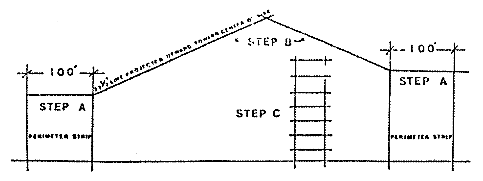
Cross Section Sketch of Height Controls
Step A: Height requirement(s) for one-hundred-foot perimeter strip is determined by adjacent zoning
Step B: Height requirement(s) interior to the perimeter strip is determined by a twenty-two-and- one-half-degree line projected upward toward center of the site
Step C: No structure shall exceed the height permitted by the most liberal on-site residential zoning district plus one (1) floor and plus additional height for unenclosed floors
(Ord. No. 73-28, § 2, 3-20-73; Ord. No. 74-41, § 1, 6-4-74; Ord. No. 78-39, § 11, 6-6-78; Ord. No. 96-127, § 25, 9-4-96)
Sec. 33-284.19. - Perimeter setback.
For structures not exceeding thirty-five (35) feet in height, minimum setbacks from property lines shall be twenty-five (25) feet. For structures over thirty-five (35) feet in height, the setback shall be increased by forty (40) percent of the additional height.
(Ord. No. 73-28, § 2, 3-20-73)
Sec. 33-284.20. - Convenience retail facilities.
Planned developments of three hundred (300) or more residential units that do not include BU Zoning shall be permitted to have food, drug, and personal service convenience retail service facilities not exceeding one thousand five hundred (1,500) square feet of gross retail floor area. An additional three (3.0) square feet of gross retail area shall be permitted for each residential unit above three hundred (300) units; provided, however, that the maximum square footage for such facilities does not exceed four thousand (4,000) square feet and provided that such services relate to the needs of the inhabitants of the proposed complex; such service facilities and identification signs for said service facilities are not visible from public roads; and such service facilities and signs are designed as an integral part of the total design as determined by site plan review.
Where an RU-4 or RU-4A District constitutes a part of the planned development, densities resulting from tracts zoned under either of these districts shall not be used in determining the amount of convenience retail facilities.
(Ord. No. 73-28, § 2, 3-20-73; Ord. No. 78-39, § 12, 6-6-78)
Sec. 33-284.21. - Plan review procedure.
The application for a planned development shall be reviewed by the Department to determine its compliance with applicable regulations and review criteria contained herein. An instrument, suitable for recording, shall be submitted prior to the advertising of the public hearing, which covenants that development will occur substantially in accordance with plans approved at the public hearing.
The Community Zoning Appeals Board shall review the plans and documents, and may approve, approve with modifications, or disapprove the application.
If a Community Zoning Appeals Board incorporates specific modifications to the planned development in its resolution of approval, those modifications shall be made by the applicant prior to filing documents and plans with the Department. Such filing shall be completed within sixty (60) working days from date of a Community Zoning Appeals Board's action. Failure to do so shall nullify the Community Zoning Appeals Board's action unless waived by formal vote of the Community Zoning Appeals Board.
Subsequent to the public hearing, minor design modifications may be granted by approval of the Director, provided that such modifications do not result in an increase in the approved number of dwelling units or approved maximum commercial floor area and provided that the design modifications are in general agreement with the intent of this article.
Required exhibits. The following exhibits shall be prepared by design professionals such as architects and landscape architects and shall be filed with the application for a planned development:
(1)
A plan indicating existing zoning on site and adjacent areas.
(2)
Aerial photograph or map indicating site and development in the immediate area.
(3)
A plan and cross section(s), at the same scale, of the height envelope.
(4)
The use, height, bulk, dwelling unit per net acre and location of all buildings and other structures including specific locations for all commercial activities—models may be required when needed for adequate review.
(5)
Aerial perspective sketches of the total project.
(6)
Pedestrian and vehicular circulation systems.
(7)
Landscape development plan in accordance with Chapter 18A of this Code.
(8)
The design for entrance features and the signage system.
(9)
Parking layouts and drives.
(10)
Figures indicating the following:
(a)
Net density per acre for the total project and the total number of residential units, including hotel and motel units.
(b)
The total amount of gross retail floor area or the total amount of gross convenience retail facilities as provided in Section 33-284.20.
(c)
Amount and percentage of common open space by categories provided in Section 33-284.15.1.
(d)
Amount and percentage of private open space as required in Section 33-284.16.
(e)
Number of parking spaces as related to the amount of residential and commercial development.
(f)
In addition, the methods used to determine the above figures shall be provided. Where practicable, such material shall be prepared in a table format.
(11)
Other material required for an adequate plan review by the Department.
Plan review standards. The following criteria shall be utilized in the plan review process:
(1)
Purpose and intent—The proposed development fulfills the purpose and intent of this article.
(2)
Planning studies—Design or planning studies accepted or approved by the Board of County Commissioners that include development patterns or environmental design criteria which would apply to the development proposal under review shall be utilized in the plan review process.
(3)
Exterior spatial relationships—The three-dimensional airspace created by the arrangement of the structures and landscape shall produce spatial relationships that function with the intended use and occupancy of the project and are compatible with the development or zoning in the adjoining area.
(4)
Landscape—Landscape shall be preserved in its natural state insofar as is practicable by minimizing tree removal. Landscaping shall be used to shade and cool, direct wind movements, provide shade, enhance architectural features, relate structure design to the site, visually screen noncompatible uses and block noise generated by the major roadways and intense-use areas.
(5)
Buffers—Buffering elements that provide a logical transition to adjoining existing or permitted uses shall be provided.
(6)
Scale—Scale of proposed structures shall be compatible with surrounding proposed or existing uses or shall be made compatible by the use of buffering elements.
(7)
Privacy—Due consideration of aural and visual privacy shall be evidenced in the design of the overall development and in the design of individual units.
(8)
Building configuration—Access for emergency equipment to various parts of the building shall be considered in the design of the project. Buildings shall be arranged in a manner that allows sufficient light and air to penetrate the development. The elimination of the first floor of structures for purposes of improved ventilation at ground level shall be encouraged.
(9)
Circulation—Pedestrian, bicycle trails and equestrian trails shall be separated from auto circulation insofar as is practicable and all circulation systems shall adequately serve the needs of the development and be compatible and functional in its relationship to circulation systems outside the development.
(10)
Energy conservation—Design methods to reduce energy consumption shall be encouraged. Energy conservation methods may include, but not be limited to, natural ventilation of structures, siting of structures in relation to prevailing breezes and sun angles, insulation of structures, use of landscape material for shade, direction of breezes and transpiration.
(11)
Subtropic characteristics—Subtropic characteristics of the area should be considered in the architectural design and site planning of the project. The provision of sun control devices, shaded areas, vegetation, roof terraces, and similar features characteristic of subtropical design shall be considered.
(12)
Parking areas—Parking areas shall be provided that are screened and so located as not to interfere with the livability of the development, its environs, and adjacent properties.
(13)
Service areas—Service areas shall be provided that are screened and so located as not to interfere with the livability of the development or adjacent properties.
(14)
Building height—Building height shall be in scale with the development in surrounding areas. As a maximum, building heights shall not exceed the height limitations hereinabove established.
(15)
Open space—A variety of open spaces shall be provided, appropriate to the needs of the particular type of development. Open space shall relate to any natural characteristics in such a way as to preserve and enhance their scenic and functional qualities to the fullest extent possible and shall be so located and developed as to be easily accessible to all residents of the development.
(16)
Visual screening for decorative walls—In an effort to prevent graffiti vandalism, the following options shall be utilized for walls abutting zoned or dedicated rights-of-way:
(a)
Wall with landscaping. The wall shall be setback two and one-half (2½) feet from the right-of-way line and the resulting setback area shall contain a continuous extensively landscaped buffer which must be maintained in a good healthy condition by the property owner, or where applicable, by the condominium, homeowners or similar association. The landscape buffer shall contain one (1) or more of the following planting materials:
(1)
Shrubs. Shrubs shall be a minimum of three (3) feet in height when measured immediately after planting and shall be planted and maintained to form a continuous, unbroken, solid, visual screen within one (1) year after time of planting.
(2)
Hedges. Hedges shall be a minimum of three (3) feet in height when measured immediately after planting and shall be planted and maintained to form a continuous, unbroken, solid, visual screen within one (1) year after time of planting.
(3)
Vines. Climbing vines shall be a minimum of thirty-six (36) inches in height immediately after planting.
(b)
Metal picket fence. Where a metal picket fence abutting a zoned or dedicated right-of-way is constructed in lieu of a decorative wall, landscaping shall not be required.
(Ord. No. 73-28, § 2, 3-20-73; Ord. No. 74-21, § 3, 4-3-74; Ord. No. 74-41, § 1, 6-4-74; Ord. No. 78-39, § 13, 6-6-78; Ord. No. 95-19, § 18, 2-7-95; Ord. No. 95-215, § 1, 12-5-95; Ord. No. 95-223, § 1, 12-5-95; Ord. No. 96-127, § 26, 9-4-96; Ord. No. 99-38, § 19, 4-27-99; Ord. No. 06-23, § 1, 2-21-06)