
Miami Dade County Unincorporated
City Zoning Code
City Zoning Code
ARTICLE XXXVII
AIRPORT ZONING57
Editor's note— Ord. No. 19-112, § 2, adopted Nov. 19, 2019, repealed the former Art. XXXVII, §§ 33-330—33-350, and enacted a new Art. XXXVII as set out herein. The former Art. XXXVII pertained to Miami International Airport (Wilcox Field) zoning and derived from Ord. No. 69-39, §§ 1—16, adopted July 9, 1969; Ord. No. 78-78, §§ 1—3, adopted Nov. 7, 1978; Ord. No. 86-83, § 1, adopted Oct. 28, 1986; Ord. No. 95-215, § 1, adopted Dec. 5, 1995; Ord. No. 98-125, § 21, adopted Sept. 3, 1998; Ord. No. 99-65, § 1, adopted June 8, 1999; Ord. No. 04-203, §§ 1—13, adopted Nov. 30, 2004; Ord. No. 05-187, § 1, adopted Oct. 18, 2005; Ord. No. 07-92, §§ 1—16, adopted July 10, 2007; Ord. No. 12-56, §§ 1, 2, adopted July 3, 2012; and Ord. No. 18-40, § 1, adopted May 1, 2018.
Sec. 33-330.- Legislative Intent, Findings, Purpose, and Applicability in the Incorporated and Unincorporated Areas.
(A)
Legislative intent, findings, and purpose.
(1)
The Board hereby declares and finds that the uncoordinated use of lands within the County in relation to the County's airport facilities threatens the orderly development and the health, safety, order, convenience, prosperity, and welfare of the present and future citizens of this County. The Board further finds that the Comprehensive Development Master Plan ("CDMP") was enacted to assure for all people of the County an attempt to create safe, healthful, productive, and aesthetically and culturally pleasing surroundings; to attain the widest range of beneficial uses of the environment without unreasonable degradation, risk to the health or safety, or other undesirable and unintended consequences, to preserve important historic, cultural, and natural aspects of our national heritage; to maintain, wherever possible, an environment that supports diversity and variety of individual choice; to achieve a balance between population and resources which will permit the high standards of living and a wide sharing of life's amenities, and to enhance the quality of renewal resources and approach the maximum attainable recycling of depletable resources.
(2)
Among the CDMP provisions designed to achieve these ends are goals, objectives, and policies to: ensure the provision of an integrated economic environment and community-sensitive and balanced system of air transportation, facilities, and services; maximize compatibility between airports and the surrounding communities; and maximize aviation's support of local and regional economic growth.
(3)
In furtherance of these goals, objectives, and policies, the Board finds that the coordinated review and analysis of its airport facilities and surrounding communities is necessary to carry on a central metropolitan government. Coordinated review and analysis of airport facilities and the surrounding communities' present and future land uses is susceptible to, and would be most effectively carried on, under a uniform plan of regulation applicable to the County as a whole. The planning of the efficient land use around the airports, combined with other plan implementation tools, can be effectively used in meeting social, economic, and environmental needs and in creating a major influence on metropolitan development patterns and lifestyles. The capability of an efficient, safe airport system and associated industry and businesses, acting in conjunction with other urban services, including public and private educational facilities, to establish general development trends, is well recognized.
(4)
A maximum coordination of the airport system requirements and land use policy decisions is therefore essential to optimize the role of the airport system as a potent tool for implementing the desired patterns of metropolitan development in the County. To this end, height restrictions within identified areas around airports were developed in coordination with the Federal Aviation Administration and the City of Miami. The height restrictions are at the maximums tolerable under the current state of aviation technology.
(5)
This Board further finds that the Florida Legislature has mandated the adoption of land use regulations by the County, as a political subdivision authorized to establish and operate airports within its territorial limits, to assure compatible land uses in the areas surrounding such airports. This Board acknowledges and adopts as its own those legislative findings in Chapter 333, Florida Statutes, that airport hazards and the incompatible use of land in airport vicinities should be prevented in the interest of the public health, public safety, and general welfare.
(6)
The purpose of these regulations is to provide both airspace protection and land uses compatible with airport operations; to promote the coordinated use of lands and foster an orderly development within the County; to protect the health, safety and welfare of the County's residents and visitors; to ensure the economic benefits and capacity of the County's system of airports; and to ensure compliance with all federal, state, and local aviation regulations.
(B)
Applicability in the incorporated and unincorporated areas and to Miami-Dade County School Board facilities.
(1)
Notwithstanding the provisions of Section 33-27 or any other provisions of this chapter to the contrary, the regulations in this article shall govern the airports owned by the County and managed by the Miami-Dade Aviation Department (MDAD) or its successor agency, and the incorporated and unincorporated areas as set forth in more detail in this article that surround such airports. The airports subject to this article are Miami International Airport (MIA); Miami Executive Airport (TMB); Miami-Opa Locka Executive Airport (OPF); Miami Homestead General Aviation Airport (X51); and any other County-owned or -operated airports that may be hereafter established. The regulations in this article shall not apply to, or govern, Dade-Collier Training and Transition Airport (TNT).
(2)
Pursuant to the authority granted in the Miami-Dade County Home Rule Charter, and in lieu of the interlocal agreements referenced in Section 333.03(1)(b)(1), Florida Statutes, the regulations set forth in this article shall serve as minimum standards applicable to development in the incorporated areas, and shall be enforced by the applicable municipalities for development within their respective jurisdictions. In addition, this article shall apply to facilities that are approved and constructed pursuant to the authority of the School Board of Miami-Dade County, in accordance with Section 1013.33, Florida Statutes, requiring the location of public educational facilities to be consistent with the County's comprehensive plan and implementing land development regulations, and the Interlocal Agreement for Public Schools Facility Planning between Miami-Dade County and the School Board of Miami-Dade County, adopted pursuant to Miami-Dade County Resolution No. R-423-09, as may be amended.
(3)
In the event of a conflict with any other County or municipal land development regulations applicable to properties subject to this article, this article shall govern.
(C)
Figures and maps adopted and on file. This Board hereby adopts, approves, and ratifies all figures and maps referenced in this article, which maps and figures establish the boundaries of the land use compatibility restriction zones, noise compatibility restriction zones, airport height restriction areas, and other zones and sub-zones applicable to each airport. The maps and figures, full-scale copies of which are on file with the Department and MDAD, shall be applicable to and controlling of zoning for such zones and sub-zones.
(Ord. No. 19-112, § 2, 11-19-19)
Sec. 33-331. - Definitions.
For purposes of this article, the following definitions shall apply:
Above Mean Sea Level (AMSL) shall mean the height or elevation of an object, relative to the average sea level datum. For the purposes of this article, the datum line for mean sea level measurements shall be the same as the datum line for the geoid-based North American Vertical Datum of 1988 (NAVD 88).
Aeronautical Study shall mean an FAA study, conducted in accordance with the standards of 14 C.F.R. part 77, subpart C, and FAA policy and guidance, regarding the effect of proposed construction or alteration on the operation of airport facilities and the safe and efficient use of navigable airspace.
Airport shall mean an area of land or water designed and set aside for the taking off and landing of aircraft and used or to be used in the interest of the public for such purpose.
Airport Elevation shall mean the established elevation of the highest point on the usable runway.
Airport Hazard shall mean an obstruction to air navigation that affects the safe and efficient use of navigable airspace or the operation of planned or existing airport or communication facilities.
Aviation-Related School shall mean any educational facility whose greater portion of curriculum is devoted to education or training in the science and art of flight and airports, including, but not limited to: the operation and construction of aircraft, aircraft power plants and accessories, including the repair, packing and maintenance of parachutes; the design, establishment, construction, extension, operation, improvement, repair or maintenance of airports or other air navigation facilities; and flight instruction or subjects pertaining thereto.
Department shall mean the Miami-Dade County Department of Regulatory and Economic Resources or successor department.
Development Permit shall mean any building permit, zoning permit or approval, subdivision approval, rezoning, certification, special exception, variance, certificate of appropriateness for historically designated property, or any other official action of the County or any municipality having the effect of permitting the development, alteration, use, or occupancy; or change of use or occupancy, of any land or structure.
Educational facilities shall mean any educational facilities as defined in Articles XA and XI of this chapter, but not vocational or trade schools.
FAA shall mean the Federal Aviation Administration, or its successor agency.
Height shall mean the maximum vertical distance Above Mean Sea Level (AMSL) to the highest point of the structure or tree.
MDAD shall mean the Miami-Dade Aviation Department, or its successor agency.
MDAD Director shall mean the Director of MDAD, unless the context clearly indicates otherwise. MDAD Director shall also include the MDAD Director's designee.
Obstruction shall mean any of the following that exceed the federal obstruction standards contained in 14 Code of Federal Regulations (C.F.R.) part 77, subpart C:
(a)
An object of natural growth, terrain, or permanent or temporary construction or alteration, including equipment or materials used in the process, and any permanent or temporary apparatus; or
(b)
The alteration of any permanent or temporary existing structure by a change in its height, including appurtenances, lateral dimensions, and any equipment or materials used in the process.
RER Director shall mean the Director of the Department, unless the context clearly indicates otherwise. RER Director shall also include the RER Director's designee.
Runway shall mean the defined area on an airport prepared for landing and take-off of aircraft along its length.
Structure shall mean an object constructed, erected, altered, installed, or transported, including, but not limited to, buildings, flagpoles, lightning rods, parapets, antennas, spires, cell towers, roof-mounted equipment or appurtenances, derricks, draglines, cranes and other boom-equipped machinery, towers, signs, smokestacks, utility poles, power generation equipment, or overhead transmission lines, whether temporary or permanent.
Temporary event shall mean any tethered balloons, unmanned aircrafts, lasers, fireworks, kites, or similar objects, things, or occurrences.
Temporary structure or crane shall mean any structure, construction crane, or similar equipment that is not permanently put into place.
Tree shall mean tree or other flora, whether naturally occurring or placed by man or machine, whether temporary or permanent.
(Ord. No. 19-112, § 2, 11-19-19; Ord. No. 23-48, § 1, 7-6-23)
Sec. 33-332. - Uses on Airport Property.
The CDMP policies and interpretative text governing airports provide for aviation, aviation-related, and non-aviation uses within airport property at designated locations. Accordingly, such uses shall be permitted at airports, as follows:
(A)
Aviation uses. Aviation uses shall be permitted on any land within airport property, subject to review and approval by MDAD. Aviation uses shall consist of all uses that are intrinsic to the operation of an airport, including but not limited to the following:
(1)
Runways, taxiways, aprons, and support and maintenance facilities, including, without limitation, control towers, flight service stations, access roadways, fire station, storage facilities, aircraft maintenance facilities, hangars, fuel farms and fixed-base operators.
(2)
Passenger terminals and ancillary facilities that serve the traveling public and employees of aviation uses, including, without limitation, offices, personal services, retail, restaurants, lodging, and car rental facilities where located within terminal buildings or other secured areas.
(3)
Notwithstanding anything in this Code to the contrary, airport security fences in any form, configuration, and location deemed appropriate by MDAD.
(B)
Aviation-related uses. Aviation-related uses shall be permitted on any land within airport property, subject to review and approval by MDAD. Aviation-related uses shall consist of uses that are ancillary to or supportive of aviation uses, including, without limitation, manufacturing, storage, office, and service uses that are ancillary to or supportive of aviation uses and that may be located outside passenger terminals or other secured areas.
(C)
Non-aviation uses—Lands designated government property (GP district). The following non-aviation uses may be approved within airport properties on land designated for such uses in the CDMP and zoned GP outside of passenger terminals and other secured areas, provided that such uses are compatible with, and not disruptive of, airport operations occurring on such lands and in compliance with all applicable regulations of the FAA and other applicable law:
(1)
Lodgings, such as hotels and motels, subject to the standards of the BU-2 district.
(2)
Office buildings, subject to the standards of the BU-2 district, except that such facilities shall not be permitted in concourses.
(3)
Industrial uses such as distribution, storage, manufacturing, research and development, and machine shops, subject to the site development standards of the IU-1 zoning district.
(4)
Agricultural uses, subject to the standards of the AU district.
(5)
Retail, restaurants, and personal service establishments, subject to the standards of the BU-2 district.
(D)
Administrative Site Plan Review required. All non-aviation uses shall require administrative site plan review by the Department and shall be subject to the site plan review standards provided herein.
(1)
The purpose of the site plan review is to encourage logic, imagination, innovation, and variety in the design process and encourage the congruity of the proposed development and its compatibility with the surrounding area.
(2)
Each non-aviation use shall comply with requirements of this chapter and other applicable law, including, but not limited to, FAA regulations, the current airport layout plan on file with MDAD governing permissible uses on the entire airport property, and the MDAD design guidelines.
(3)
All development shall comply with the off-street parking requirements of this chapter, and with the landscaping requirements of Chapter 18A.
(4)
Required exhibits. The following exhibits shall be prepared by design professionals, such as architects and landscape architects, and submitted to the Department:
(a)
Dimensioned site plans indicating, at a minimum, the following information:
(i)
Existing zoning on the site and on adjacent properties.
(ii)
The basic use, height (based on feet AMSL and to the highest point of the structure), bulk, and location of all buildings and other structures with setbacks.
(iii)
Vehicular and pedestrian circulation systems including connection(s) to existing or proposed roadway and sidewalk system and the layout of parking, service, and loading areas.
(iv)
Graphics and notations indicating the site planning or structure design methods used to minimize the impact of those industrial activities that could have a negative impact on existing or proposed adjacent land uses.
(v)
Sketches of design elements to be used for buffering surrounding uses.
(b)
Elevation of the proposed buildings and other major design elements.
(c)
Landscape plans showing landscaping and trees in accordance with Chapter 18A.
(d)
Figures indicating the following:
(i)
Proposed uses.
(ii)
Gross floor area (in square feet).
(iii)
Land area:
Gross lot area (in square feet or acres).
Net lot area (in square feet or acres).
(iv)
Landscaped open space (showing both required and provided open space, in both total square feet and as a percentage of net lot area).
(v)
Trees (showing number of trees provided and required).
(vi)
Off-street parking spaces (showing number spaces provided and required).
(5)
Review Criteria. The following shall be considered in the plan review process:
(a)
Planning studies: Planning studies approved by the Board that include development patterns or environmental and other design criteria shall be considered in the plan review process.
(b)
Landscape: Landscape shall be preserved in its natural state insofar as is practicable by minimizing removal of existing vegetation. Landscape shall be used to shade and cool, enhance architectural features, relate structure design to the site, visually screen noncompatible uses, and ameliorate the impact of noise.
(c)
Compatibility: The architectural design and scale of the proposed structures shall be compatible with surrounding existing or proposed uses or shall be made compatible by the use of screening elements. Screening elements can include such devices as trees and shrubs, walls and fencing, berming or any combination of these elements. Visual buffering shall be provided between parking and service areas and adjacent non-commercial uses.
(d)
Emergency access: Unobstructed on-site access for emergency equipment shall be considered.
(e)
Circulation: Internal vehicular and pedestrian circulation systems shall be designed to function with existing and/or approved systems outside the development. Vehicular traffic generated from the industrial activity should be routed in such a manner as to minimize impact on residential development.
(f)
Energy conservation: Applicants shall comply with the Energy Conservation Standards set forth in Sections 553.951—553.975, Florida Statutes.
(g)
Visual screening for decorative walls: To prevent graffiti vandalism, the following options shall be utilized for walls abutting zoned or dedicated rights-of-way:
(i)
Wall with landscaping. The wall shall be setback 2½ feet from the right-of-way line, and the resulting setback area shall contain a continuous landscaped buffer, which shall be maintained in a good, healthy condition. The landscape buffer shall contain one or more of the following planting materials:
(1)
Shrubs. Shrubs shall be a minimum of 3 feet in height when measured immediately after planting and shall be planted and maintained to form a continuous, unbroken, solid, visual screen within one year after time of planting.
(2)
Hedges. Hedges shall be a minimum of 3 feet in height when measured immediately after planting and shall be planted and maintained to form a continuous, unbroken, solid, visual screen within one year after time of planting.
(3)
Vines. Climbing vines shall be a minimum of 36 inches in height immediately after planting.
(ii)
Metal picket fence. Where a metal picket fence abutting a zoned or dedicated right-of-way is constructed in lieu of a decorative wall, landscaping shall not be required.
(h)
Signage. Non-aviation uses shall comply with the signage requirements of Article VI of this chapter and MDAD Design Guidelines, except that entrance features are not required to comply with Section 33-112(a)(1), (g), (h) and (i).
(6)
Time for review. The Department shall review and approve or deny each submitted plan within 30 days from the date of submission. Denials shall be in writing and shall specifically set forth the grounds for denial. Applications that are deemed complete but that have not received a decision within 30 days shall be deemed approved.
(7)
Appeals. Notwithstanding any other the provisions of this chapter to the contrary, an aggrieved party may appeal an administrative site plan review decision to the Board in accordance with the procedures set forth in Section 33-314 for appeals of administrative decisions. Appeals must be filed within 30 days of notice of the written decision or shall be deemed waived.
(Ord. No. 19-112, § 2, 11-19-19)
Sec. 33-333. - Land Use Compatibility and Height/Airspace Regulations; Nonconforming Uses; Disclosures.
(A)
Land Use Compatibility Regulations. The objective of these land use compatibility regulations is to guide incompatible land uses away from airport environs and to encourage compatible land uses to locate around airport facilities. The land use compatibility regulations contained herein seek to address the impact of aircraft operations on surrounding uses, to safeguard the quality of life in the surrounding communities while increasing the efficiency of airports as economic generators. The following regulations shall apply to land uses occurring within the designated restriction zones established for the respective County airports and surrounding areas, as depicted on each airport's land use and noise compatibility restriction zones map:
(1)
Land use compatibility restriction zones:
(a)
Runway Protection Zone (RPZ).
(i)
The Runway Protection Zone (RPZ) is a trapezoidal area centered about the extended runway centerline that begins 200 feet beyond the end of runway, the dimensions of which shall be based on the type of aircraft and approach visibility minimum associated with that runway end. The FAA considers the RPZ as the most critical safety zone.
(ii)
Within the RPZ, new stormwater retention/detention facilities shall be permitted, following receipt of an opinion from the FAA. All other new buildings and structures, recreational uses, transportation facilities, fuel storage facilities, hazardous material storage, wastewater treatment facilities, and above-ground utility infrastructure proposed to be located within the RPZ shall only be permitted after review and approval by MDAD to assure compatibility with airport operations, following receipt of an opinion from the FAA.
(iii)
Uses prohibited in the Outer Safety Zone (OSZ) and Critical Approach Zone (CAZ) shall also be prohibited in the RPZ.
(iv)
In no event shall these prohibitions be varied.
(b)
Outer Safety Zone (OSZ).
(i)
The Outer Safety Zone (OSZ) is a trapezoidal area extending outward from the RPZ to a point that is 5,200 feet from the runway end.
(ii)
Within the OSZ, the following shall be prohibited: new residential construction; educational facilities; hospitals; religious facilities; auditoriums; and theaters. In no event shall these prohibitions be varied with respect to Miami International Airport. It is provided, however, that the following shall not be subject to this prohibition:
1.
aviation-related schools;
2.
hotels and motels and their ancillary uses;
3.
structures used in connection with public transportation; and
4.
workforce housing developments that meet all the requirements set forth in section 33-333.1(B)(1)(6), provided that:
a.
prior to issuance of any building permit for such development, the applicant furnishes proof to the Department and to MDAD that the FAA has either approved or expressed no objection to such development;
b.
such developments shall be eligible for such bonuses as are provided in Article XIIA to the extent they also comply with that article; and
c.
municipalities shall, as a minimum standard, allow such workforce housing developments within their jurisdictions, and be subject to the provisions set forth in subparagraph 33-193.7(C)(2) regarding noncompliance with minimum standards.
It is provided, however, that this allowance for development of workforce housing within the OSZ around the Miami Executive Airport shall not be implemented prior to March 15, 2029.
(iii)
Uses prohibited in the Critical Approach Zone (CAZ) shall also be prohibited in the OSZ.
(c)
Critical Approach Zone (CAZ): The Critical Approach Zone (CAZ) is a trapezoidal area extending outward from the RPZ to a point that is 10,200 feet from the runway end. The following uses shall be prohibited within this zone:
(i)
Hospitals, skilled nursing facilities, assisted living facilities, adult day care facilities, day nurseries, and educational facilities, excluding aviation-related schools. In no event shall the prohibition on educational facilities be varied.
(ii)
Establishments or uses that emit smoke, gases, or dust in quantities or densities sufficient to jeopardize the safe use of the airport. In no event shall these prohibitions be varied.
(iii)
Establishments or uses that create electrical interference with radio communications between the airport and aircraft; make it difficult for aircraft pilots and tower control operators to distinguish between airport lights, aircraft and others; result in glare in the eyes of aircraft pilots using the airport, or tower control operators; impair visibility in the vicinity of the airport; or otherwise endanger the landing, taking off, or maneuvering of aircraft. In no event shall these prohibitions be varied.
(iv)
Landfills, as defined in Section 403.703, Florida Statutes; and any associated uses that attract or sustain birds and bird movements. In no event shall these prohibitions be varied.
(2)
Noise compatibility restriction zones:
(a)
75 DNL Zone.
(i)
The 75 DNL Zone is a contour depicting concentrations of aircraft noise around an airport based on day and night noise levels averaged over a year at 75 decibels and greater.
(ii)
New residential construction and educational facilities, excluding aviation-related schools, are prohibited within this zone.
(b)
65-to-74 DNL Zone.
(i)
The 65-to-74 DNL Zone is a contour depicting concentrations of aircraft noise around an airport based on day and night noise levels averaged over a year at 65-to-74 decibels.
(ii)
All new uses shall incorporate at least a 25 decibel outdoor-to-indoor Noise Level Reduction (NLR) into design and construction.
(c)
X51 Noise Compatibility Restriction Zone.
(i)
Notwithstanding any other provision to the contrary, for Miami Homestead General Aviation Airport (X51), the 75 DNL Zone and 65-to-74 DNL Zone shall not apply. Instead, the noise compatibility restriction zone for X51 shall be provided in accordance with Section 333.03(2)(d), Florida Statutes.
(ii)
Pursuant to Florida law, new residential construction and educational facilities, excluding aviation-related schools, are prohibited within this zone.
(3)
Divided parcel in land use or noise compatibility restriction zones. Where a single parcel of land is partially located in one or more land use or noise compatibility restriction zones, development on each portion of the parcel remains subject to the land use or noise compatibility regulations applicable to that portion. Notwithstanding the foregoing or any other prohibitions in this article, residential development on a parcel of land that was partially located within the OSZ as of November 29, 2019, and that is not otherwise permitted by subparagraph (A)(1)(b)(ii) above, may be permitted by the County Commission, after receiving a recommendation from MDAD, provided that:
(a)
The proposed development would not compromise safety or airport operations;
(b)
At least 50 percent of the parcel was located outside of the OSZ prior to November 29, 2019;
(c)
The proposed residential units are part of a mixed-use development;
(d)
The parcel was, prior to November 29, 2019, and continues to be, located in a zoning district that allows the inclusion of residential uses as part of the mixed-use development;
(e)
The parcel is located on a major roadway as designated on the County's Comprehensive Development Master Plan (CDMP);
(f)
The development will incorporate at least 25 decibel outdoor-to-indoor Noise Level Reduction (NLR) into the design and construction of the residential units; and
(g)
The sale of residential units within the development will comply with the land use or noise compatibility restriction zone disclosure requirements of this article.
(4)
Land use or noise compatibility restriction zone disclosure.
(a)
Definitions. As used in this section, the term:
(i)
Affected Land means any parcel of land that is located wholly or partially within the RPZ, OSZ, CAZ, 75 DNL Zone, or 65-to-74 DNL Zone, as defined in this section.
(ii)
Interest in real property means a non-leasehold, legal, or equitable estate in land, or any severable part thereof, created by deed, contract, mortgage, easement, covenant, or other instrument.
(iii)
Purchaser means a buyer, transferee, grantee, donee, or other party acquiring an interest in real property.
(iv)
Real property transaction means the sale, grant, conveyance, mortgage, or transfer of an interest in real property.
(v)
Seller means a transferor, grantor, donor, or other party conveying an interest in real property.
(b)
Disclosure statement requirement. Prior to the execution of any instrument committing the Purchaser to acquire title to, or any other interest in, any Affected Land, the Seller shall provide the Purchaser with the following statement, which shall be set forth on a separate sheet of paper and shall be signed and dated by the prospective Purchaser on the date received:
LAND INVOLVED IN THIS TRANSACTION IS LOCATED WITHIN AN AIRPORT LAND USE AND/OR NOISE COMPATIBILITY RESTRICTION ZONE AS ESTABLISHED IN CHAPTER 33, ARTICLE XXXVII OF THE CODE OF MIAMI-DADE COUNTY. THIS DESIGNATION APPLIES TO PROPERTIES THAT ARE LOCATED IN CLOSE PROXIMITY TO A COUNTY AIRPORT AND MAY BE IMPACTED BY FLIGHT OPERATIONS. SUCH IMPACTS MAY INCLUDE, BUT ARE NOT LIMITED TO, NOISE, VIBRATION, ODORS, DUST, AND FUMES. USE OF PROPERTY LOCATED WITHIN THE AIRPORT LAND USE COMPATIBILITY RESTRICTION ZONE IS SUBJECT TO COMPLIANCE WITH ARTICLE XXXVII (AIRPORT ZONING) OF THE CODE OF MIAMI-DADE COUNTY.
(c)
Acknowledgment of airport land use restriction area disclosure statement on instrument of conveyance. The Seller shall ensure that the following statement appears in a prominent location on the face of any instrument conveying title to, or any other interest in, any Affected Land. Such statement must be signed by the Purchaser, notarized, and recorded with the Clerk of the Court:
I HEREBY CERTIFY THAT I HAVE READ, UNDERSTAND, AND HAVE SIGNED THE AIRPORT LAND USE AND/OR NOISE COMPATIBILITY RESTRICTION ZONE DISCLOSURE STATEMENT FOR THE SALE OF, OR OTHER TRANSACTION INVOLVING, THIS PARCEL OF AFFECTED LAND AS REQUIRED BY SECTION 33-333 OF THE CODE OF MIAMI-DADE COUNTY, FLORIDA.
(d)
Penalties. Any Seller who violates any provision of this section, or fails to comply therewith, or with any lawful rule, regulation, or written order promulgated under this section, shall be subject to the penalties, civil liability, attorney's fees, and enforcement proceedings set forth in Article I of this chapter, and to such other penalties, sanctions, and proceedings as may be provided by law. Miami-Dade County shall not be held liable for any damages or claims resulting from the Seller's failure to comply with provisions of this section.
(5)
Municipal opt-out of certain land use compatibility restrictions at general aviation airports. Any municipality located in whole or in part in the OSZ or CAZ of any general aviation airport (i.e., Miami Executive Airport (TMB), Miami-Opa Locka Executive Airport (OPF), or Miami Homestead General Aviation Airport (X51)) may, by municipal ordinance, opt out of certain land use compatibility restrictions in the OSZ and CAZ. In no event, however, shall a municipality be permitted to opt out of those prohibitions that are dictated by federal or state law, rule, or regulation, including, specifically, the prohibition on establishments or uses listed in subparagraphs (A)(1)(c)(ii), (iii), and (iv) above. Any municipality opting out shall, within 30 days of the adoption of a municipal ordinance, provide written notice and a copy of the ordinance to the Director and MDAD.
(B)
Height/Airspace Regulations. The objective of these height/airspace regulations is to ensure that airspace in Miami-Dade County is safe, navigable, and free of obstructions.
(1)
Airport height restriction zones. Airport height restriction zones are established for each airport, as depicted on the "Airport Height Restriction Zone Map" adopted in this article for each respective airport. All uses of land within airport height restriction zones shall be subject to the following restrictions, and except as otherwise provided in this section, these restrictions shall not be varied.
(a)
Imaginary surfaces. The imaginary surfaces that control the airport height restriction zones are established in accordance with FAA Rule 14 CFR Part 77 (Safe, Efficient Use and Preservation of the Navigable Airspace) and the United States Standard for Terminal Instrument Procedures (TERPS). Airport height controlling surfaces are defined as follows:
(i)
Primary Surface (P) means a surface longitudinally centered on a runway and extending 200 feet beyond each end of that runway. The elevation of any point on a primary surface is the same as the elevation of the nearest point on the runway centerline.
(ii)
Approach Surface (IA and NA) means a surface longitudinally centered on the extended runway centerline and extending outward and upward from each end of the Primary Surface. An approach surface is applied to each end of each runway based upon the type of approach available or planned for that runway end, as follows:
(1)
Instrument Approach Surface (IA) refers to runways with instrument landings and takeoffs (instrument approach/runway).
(2)
Non-Instrument Approach Surface (NA) refers to runways without instrument landings and takeoffs (non-instrument approach/runway).
(iii)
Transitional Surface (TR) means a surface that extends outward and upward at right angles to the runway centerline and the runway centerline extended from the sides of the Primary Surface and from the sides of the Approach Surfaces at a slope of 7 to 1.
(iv)
Horizontal Surface (HZ) means a horizontal plane 150 feet above the established airport elevation, the perimeter of which is constructed by swinging arcs from the center of each end of the Primary Surface of each runway and connecting the adjacent arcs by lines tangent to those arcs. The horizontal surface does not include the Primary, Approach, or Transition Surfaces.
(v)
Conical Surface (CN) means a surface extending outward and upward from the periphery of the horizontal surface at a slope of 20 to 1.
(vi)
Miami International Airport - High Structure Set-Aside Area (MIA-HSA) provides for tall buildings and other structures that may be permitted with limited impact on the capacity and operation of Miami International Airport (MIA). The MIA-HSA is comprised of surfaces with different height restrictions. The MIA-HSA embraces and includes all of the land and water lying within that portion of the City of Miami, Florida depicted in Figure 3 in Section 33-337. In the event of a conflict with any other imaginary surface specified within this article, the permissible height of the MIA-HSA shall govern.
(vii)
Airport Height Variance Eligible Areas (HVEA) are the areas surrounding airports where variances of the applicable height restrictions may be applied for in accordance with this article. The Miami International Airport - Height Variance Eligible Area (MIA-HVEA) constitutes the areas located to the north and south of Miami International Airport, as depicted in Figure 4, in Section 33-337. The HVEAs for Miami Executive Airport, Miami-Opa Locka Executive Airport, and Miami Homestead General Aviation Airport are depicted in figures set forth in Sections 33-338, 33-339, and 33-340, respectively.
(2)
Violations; airport hazards. Except as otherwise provided in this article, any structure or tree that is erected or increased above the height of the applicable controlling surface shall be considered an airport hazard and shall be deemed a violation of this article.
(3)
Permits; review and issuance. Except as otherwise provided in this article, no development permit for any structure or tree (whether permanent or temporary, natural or man-made) to be erected, planted, located, or otherwise established within an airport height restriction area shall be issued unless such development permit has been reviewed and approved in accordance with and for compliance with this subsection.
(C)
Nonconforming uses or structures. This article shall not be construed to require the removal, lowering, or other change or alteration of any obstruction that was legally established prior to November 29, 2019, or otherwise interfere with the continuance of any legally established nonconforming use or structure, except as provided herein, and subject to the following requirements. It is provided, however, that notwithstanding any provisions of this code authorizing the alteration or improvement of a nonconforming use or structure, no obstruction shall be permitted to become a greater hazard to air navigation than it was when it was legally established. It is further provided that notwithstanding any provisions of this code, nothing herein shall be construed to limit the authority of the Director or MDAD to require or effectuate the trimming or removal of any tree or other object of natural growth that the Director or MDAD determines is a hazard to air navigation.
(1)
For purposes of this article, a "nonconforming use" means a use or structure that does not conform to the requirements of this article. Only legally established nonconforming uses shall have rights under this article. The provisions of this subsection (2)(e) shall supersede in the event of a conflict with Section 33-35 or any other provisions of this chapter to the contrary addressing nonconforming uses or structures.
(2)
Any permit or variance approving the alteration or improvement of a nonconforming use or structure shall require the owner of the obstruction to install, operate, and maintain thereon, at his or her own expense, marking and lighting in conformance with the specific standards established by the FAA.
(3)
Whenever the appropriate building, zoning, or other County or municipal official determines that a legally established nonconforming obstruction has been abandoned or is more than 80 percent torn down, destroyed, deteriorated, or decayed, a permit or variance may not be approved if it would allow the obstruction to exceed the applicable height limit or otherwise deviate from the airport protection zoning regulations.
(4)
Whether or not an application to approve the continuation of a nonconforming use or structure is made under this article, the owner of the nonconforming obstruction may be required, at his or her own expense, to lower, remove, reconstruct, alter, or equip such obstruction with marking and lighting in conformance with the specific standards established by the FAA, as may be necessary to conform to the requirements of this article. If the owner of the nonconforming obstruction neglects or refuses to comply with such requirement for 10 days after notice, the appropriate building, zoning, or other County or municipal official may proceed to have the obstruction so lowered, removed, reconstructed, altered, or equipped and assess the cost and expense thereof upon the owner of the obstruction or the land whereon it is or was located.
(5)
Notwithstanding any other provision to the contrary, the land use restrictions for Land Use Compatibility Restriction Zones and Noise Compatibility Restriction Zones shall not be construed to require the removal, alteration, sound conditioning, or other change, or to interfere with the continued use, reconstruction, modification, or adjacent expansion of:
(a)
Any educational facility or site in existence on July 1, 1993; or
(b)
Any of the following uses, facilities, or sites in existence on or before November 29, 2019 or that, as of that date, had received final site plan approval through a public hearing, administrative site plan review, or MDAD-issued Airspace/Land Use Letter of Determination (LOD), or a valid building permit:
(i)
Hospitals, freestanding emergency rooms, urgent care facilities, skilled nursing facilities, assisted living facilities, and adult day care facilities; or
(ii)
Commercial and non-commercial parking lots and truck parking facilities, warehousing facilities, cargo container storage facilities, and railroad tracks.
Such uses, facilities and sites shall not be considered nonconforming uses or structures.
(Ord. No. 19-112, § 2, 11-19-19; Ord. No. 23-48, § 2, 7-6-23; Ord. No. 24-20, § 3, 3-5-24; Ord. No. 25-37, § 2, 5-6-25)
Sec. 33-333.1. - Additional Density Allowance for Workforce Housing Developments on Lands Around County Airports and Outside Land Use Compatibility Restriction Zones; Minimum Standards Applicable to Incorporated Areas.
(A)
Purpose and intent. The purpose of this section is to promote the development of housing that is affordable to the workers at the County's airports and that is close to the airports where they work, by authorizing additional density beyond that allowed by a property's applicable zoning district, to achieve the maximum density authorized by such property's Comprehensive Development Master Plan ("CDMP") Land Use Plan map designation.
(B)
Density allowance for workforce housing around County airports. Residential developments that are located within a radius of one mile of a County airport, and outside an airport land use compatibility restriction zone, may be permitted up to the maximum density allowed by the applicable CDMP Land Use Plan map designation, regardless of the density limits of the zoning district applicable to such property, if such development complies with all of the following:
(1)
At least 15 percent of the residential units are maintained, for a period of at least 30 years, as workforce housing units, as defined below, and subject to the following:
(a)
One-half of such workforce housing units shall be for households whose income is 100 percent or below of the most recent area median income for the County.
(b)
The property owner shall coordinate with the Housing Director, as defined in section 17-140, to monitor compliance with this subsection.
(2)
For one-half of the workforce housing units and 10 percent of any market rate units, priority in buying or leasing (including sub-leasing) such units shall be given to persons who work at the applicable County airport or who work for airlines that use the applicable airport (collectively, "airport workers").
(a)
The property owner shall be responsible for verifying that a prospective buyer or tenant is an airport worker.
(b)
If, after 3 months from the date the unit is offered for sale or lease, no airport worker has bought or rented the unit, the owner may request the Director to waive this requirement for that unit. If the Director determines that a unit that is required to be marketed to an airport worker has been marketed in good faith during the 3-month period, the Director may approve the waiver.
(c)
This requirement shall apply each time a unit is offered for sale or lease, regardless of whether a waiver was granted for a previous sale or rental.
(d)
At least 6 months prior to the projected completion date of construction, the property owner or applicant shall prepare and conduct a marketing campaign designed to inform airport workers about the development, and shall furnish proof of such campaign to the Director.
(e)
The Miami-Dade County Aviation Department ("MDAD") Director shall provide an annual report outlining how many airport workers actually reside in the workforce housing to be developed in the OSZs.
(3)
The development shall be subject to administrative site plan review pursuant to Section 33-310.4 or applicable municipal procedure and shall, as part of such review, identify the portion of the development that shall contain workforce housing units in compliance with this section.
(4)
Prior to issuance of any certificate of occupancy for such development, the property owner shall demonstrate to the Department and to MDAD the manner in which the owner shall determine that priority in buying or leasing each applicable unit shall be given to airport workers.
(5)
The development complies with all other applicable regulations of this article, including but not limited to noise compatibility requirements and height/airspace regulations.
(6)
For purposes of this section, a "workforce housing unit" means a dwelling unit, the sale, rental or pricing of which is restricted to households whose income is up to 140 percent of the most recent area median income for the County, adjusted for household size, reported by the U.S. HUD as maintained by the Department.
(C)
Eligibility for workforce housing bonuses and Live Local Act incentives.
(1)
Developments that comply with this section shall also be eligible for such bonuses as are provided in article XIIA to the extent they comply with that article.
(2)
For purposes of development in accordance with subsection 125.01055(7), Florida Statutes (2023), developments that comply with this section shall be deemed to comply with land use compatibility restriction requirements in paragraph 33-333(A)(1) but shall remain subject to other noise, height, and other requirements of this article.
(D)
Minimum standards applicable to all municipalities.
(1)
Notwithstanding any other provisions of this article to the contrary, all municipal land use regulations shall at a minimum allow residential development that complies with this section up to the maximum density allowed by the municipal comprehensive plan designation applicable to the subject property, regardless of the density limits of the zoning district applicable to such property.
(2)
The provisions set forth in subparagraph 33-193.7(C)(2) regarding noncompliance with minimum standards shall govern noncompliance with these minimum standards.
(Ord. No. 24-20, § 3, 3-5-24)
Sec. 33-334. - Procedure for Review of Applications for Development Permits and Permits for Temporary Structures, Cranes, and Events within Land Use and Noise Compatibility Restriction Zones and Airport Height Restriction Zones.
(A)
Applicability. This section shall govern the review of applications in incorporated and unincorporated areas of the County for: development permits within land use and noise compatibility restriction zones and airport height restriction zones; and permits for temporary structures, cranes, and events in airport height restriction zones.
(B)
Airspace review.
(1)
Airspace review thresholds. To ensure compliance with the airport height restriction area regulations, no permit for any structures exceeding the following thresholds shall be granted by the County, any municipality, or the School Board until the proposed development or temporary structure, crane, or event has been reviewed and approved for compatibility with airport operations by MDAD and, where applicable, the FAA in accordance with the following:
(a)
Any construction or alteration exceeding 200 feet above ground level;
(b)
Any permanent construction or alteration within the airspace review area of each of the airports; and
(c)
Any temporary structure, crane, or event exceeding an imaginary surface extending outward and upward at a slope of 100 to 1 for a horizontal distance of 20,000 feet from the nearest point of the nearest runway of a County airport.
(2)
Airspace review submittal requirements. All permit applications to be reviewed by MDAD pursuant to this article shall be in accordance with MDAD prescribed guidelines for submittals, shall be submitted in a form approved by the Director or MDAD, and shall include the following information where applicable, as determined by MDAD:
(a)
Project name;
(b)
Property address/location and folio number(s);
(c)
Proposed use;
(d)
Duration of the project;
(e)
For temporary structures, cranes, or events, proof of FAA approval shall be required in all instances;
(f)
For temporary structures and cranes, all required GPS coordinates (in degrees, minutes, and second/State Plane North American Datum - NAD 83), cross streets;
(g)
For temporary events, the GPS coordinates in NAD 83 where the event will be located, operated, sited, installed, launched or otherwise used, height to tallest reasonably anticipated point of the temporary event; and
(h)
For temporary structures and cranes, proof of MDAD's approval of the permanent, underlying structure with which the temporary crane is associated.
(C)
Permits for properties located within the land use and noise compatibility restriction zones.
(1)
Permits issued by municipalities or the School Board of Miami-Dade County. Where the application complies with the airport height regulations set forth in this article, municipal or School Board officials shall be responsible for reviewing all applications for development permits and applications for permits for temporary structures, cranes, and events within their jurisdiction for compliance with land use and noise compatibility restriction zones. The RER Director or the MDAD Director may take enforcement action in accordance with Section 33-336 where municipal or School Board permits are going to be, or have been, issued in contravention of this article.
(2)
Permits issued by the County in the unincorporated area or where the County retains jurisdiction. Where the application complies with the airport height regulations set forth in this article, the RER Director and MDAD Director shall be responsible for reviewing all applications for development permits and applications for permits for temporary structures, cranes, and events in the unincorporated area or where the County retains jurisdiction for compliance with Land Use and Noise Compatibility Restriction Zones, prior to issuance of the permit.
(D)
Requirement to close FAA determination for permanent structure or temporary structure, crane, or event. To remove any temporary airspace restrictions imposed as a result of FAA determinations in connection with permanent structures or temporary structures, cranes or events, the applicant and the owner of the subject property shall be jointly and severally responsible for closing any applicable FAA determination upon completion of the temporary project or event. Failure to do so may subject the applicant or property owner to enforcement action in accordance with this article.
(Ord. No. 19-112, § 2, 11-19-19)
Sec. 33-335. - Variances in the Incorporated and Unincorporated Areas or on School Board Property; Appeals.
Upon determination by MDAD or the applicable municipal or School Board official that the construction, alteration, or allowance of a structure, use, or tree constitutes a violation of this article in a land use compatibility restriction zone, the 65-to-74 DNL Zone, or within a Height Variance Eligible Area, a variance may be sought in accordance with the procedures below, except where the applicable regulations expressly prohibit variances. All applications for variances, whether the subject property is in the incorporated or unincorporated area or is School Board property, shall be submitted to MDAD for processing in accordance with this section. For purposes of this article, "variance" shall be synonymous with "permit," as that term is used in Section 333.07, Florida Statutes.
(A)
Pre-application conference. Before submitting an application for a variance, the applicant shall participate in a pre-application conference with MDAD. The purpose of the pre-application conference is to ascertain the project's location and scope, advise the applicant of the information needed for submittal, and explain the evaluation process.
(B)
Application. Application for a variance shall be made on a form prescribed by the MDAD Director.
(1)
Applications shall include the required exhibits set forth in Section 33-334(B).
(2)
Applications shall also include documentation showing compliance with the federal requirement for notification of the proposed project and a valid aeronautical evaluation of the project.
(C)
State review. Pursuant to Section 333.025(4), Florida Statutes, MDAD shall, upon receipt, provide a copy of the complete application for a variance to the Florida Department of Transportation's aviation office by certified mail, return receipt requested, or by a delivery service that provides a receipt evidencing delivery. To evaluate technical consistency with Chapter 333, Florida Statutes, the state shall have a 15-day review period following receipt of the application, which shall run concurrently with the County's variance process. Unless the state requests otherwise, cranes, construction equipment, and other temporary structures in use or in place for a period not to exceed 18 consecutive months are exempt from the state's review.
(D)
Determination. MDAD shall grant or deny applications for variances in accordance with the procedures, criteria, and requirements set forth herein and in Chapter 333, Florida Statutes, as may be amended from time to time. Any variance may be subject to conditions necessary to effectuate the purposes of this chapter.
(E)
Criteria. Variances from the regulations of this article shall only be granted where application or enforcement of such regulations would result in practical difficulty or unnecessary hardship and the relief granted would not be contrary to the public interest. No variance shall be approved solely on the basis that the proposed structure or use will not exceed federal obstruction standards, or any other federal aviation regulation. In evaluating whether a requested variance would be contrary to the public interest, the following factors shall be considered to the extent applicable:
(1)
The safety of persons on the ground and in the air;
(2)
The safe and efficient use of navigable airspace;
(3)
The nature of the terrain and height of existing structures;
(4)
The effect of the construction or alteration on the state licensing standards for a public-use airport contained in Chapter 330 of the Florida Statutes and the rules adopted thereunder;
(5)
The character of existing and planned flying operations and developments at the airport;
(6)
Federal airways, visual flight rules, flyways and corridors, and instrument approaches as designated by the FAA;
(7)
The effect of the construction or alteration of the proposed structure on the minimum descent altitude or the decision height at the airport;
(8)
Technological advances;
(9)
Land use density;
(10)
Public or private interest and investments; and
(11)
The cumulative effects on navigable airspace of all existing structures, proposed structures identified in the Comprehensive Development Master Plan, and all other known proposed structures and uses in the area.
(F)
Height variances limited. Notwithstanding any other provisions of this article, a variance from the height restrictions of this article may only be applied for and obtained in a Height Variance Eligible Area, as defined in Section 33-333, provided that the proposed structure or use meets applicable federal standards and regulations and has been approved by the Federal Aviation Administration.
(G)
Obstruction marking and lighting required. Notwithstanding any other provisions of this article, in granting any variances or any other authorization for any structure or use not expressly permitted herein, the owner of the structure or tree for which such authorization is being sought shall be required to install, operate, and maintain thereon, at the owner's sole expense, marking and lighting in conformance with the specific standards established by the FAA.
(H)
Appeals. MDAD shall issue a written determination approving or denying each variance application. Denials shall specify the grounds for denial. Any aggrieved party may appeal MDAD's decision to the Board of County Commissioners in accordance with the procedure established in Section 33-314 for appeals of administrative decisions.
(Ord. No. 19-112, § 2, 11-19-19)
Sec. 33-336. - Conflicting Regulations; More Restrictive Applies.
Nothing contained in this article shall be interpreted to conflict with or supersede any federal regulation pertaining to the control of airport hazards, except in those instances in which this article imposes more stringent height limitations or restrictions upon the use of land or water than are imposed or required by other County ordinance or resolution, or federal rules or regulations, in which case the provisions of this article shall govern. In addition, except where a variance in a Height Variance Eligible Area has been approved, no building permit or other development permit shall be issued for, and no structure or tree shall be allowed to, a height greater than the lower of: (1) that height stated on a valid "Determination of No Hazard" issued by the FAA; or (2) that height allowed by the regulations set forth in this article.
(Ord. No. 19-112, § 2, 11-19-19)
Sec. 33-337. - Enforcement.
(A)
This article shall be enforceable in accordance with the provisions of: Article I of this chapter; Section 1-5 and Chapter 8CC; and any applicable municipal regulations.
(B)
In addition to any other remedies available at law or in equity:
(1)
Certificates of occupancy or certificates of use shall be withheld until the County or municipality determines that a structure or use was legally established in accordance with this article; and
(2)
Any development permit that is subject to this article and is issued without the written approval of MDAD shall be voidable.
(C)
It is further provided that the RER Director or the MDAD Director are hereby authorized to appeal or commence appropriate legal action to prevent or challenge the issuance of a municipal or School Board permit for failure to comply with the requirements of this article.
(Ord. No. 19-112, § 2, 11-19-19)
Sec. 33-338. - Miami International Airport (MIA).
(A)
Non-aviation uses permitted on properties zoned GP at MIA. The minimum and maximum of land area devoted to particular non-aviation uses for those parcels designated as GP on Figure 1, full-scale copies of which are on file with MDAD and the Department, shall be as follows:
MIA NON-AVIATION AREA (±56.7 ACRES)
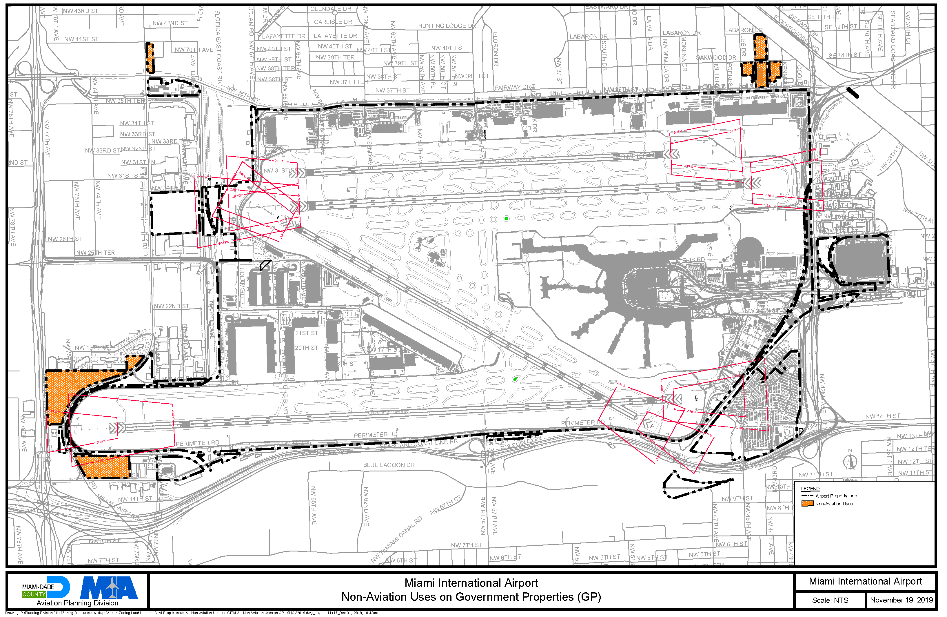
Figure 1. Miami International Airport - Non-Aviation Uses on GP Properties
(B)
Land Use and Noise Compatibility Restriction Zones at MIA. Figure 2 depicts the land use and noise compatibility restriction zones for Miami International Airport.
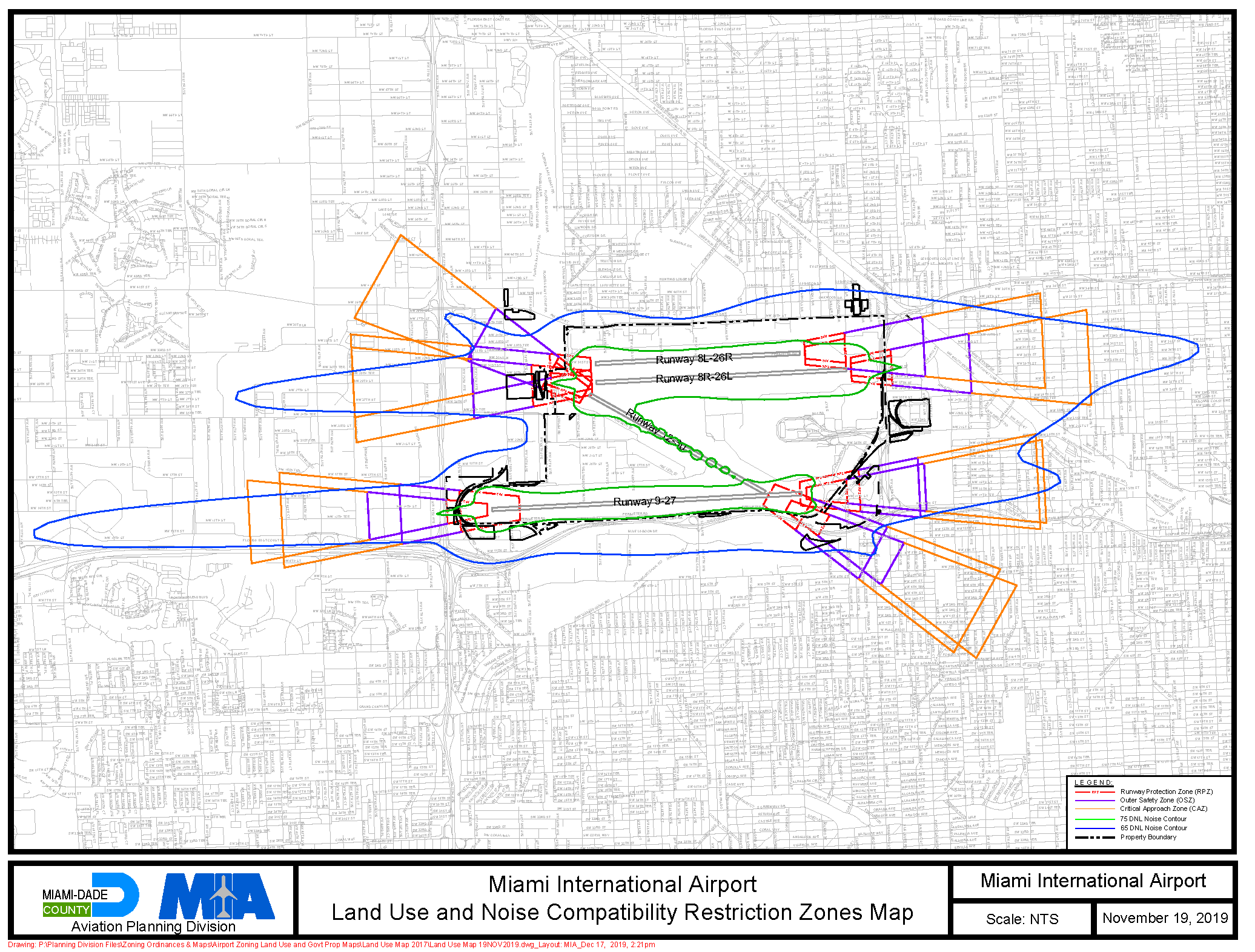
Figure 2. Miami International Airport - Land Use and Noise Compatibility Restriction
Zones
(C)
Airport Height Restriction Zones. Figure 3 depicts the airport height restriction zones for Miami International Airport. Figure 3 also depicts the Miami International Airport - High Structure Set-Aside Area (MIA-HSA), which provides a maximum allowable height of 1,049 feet AMSL.
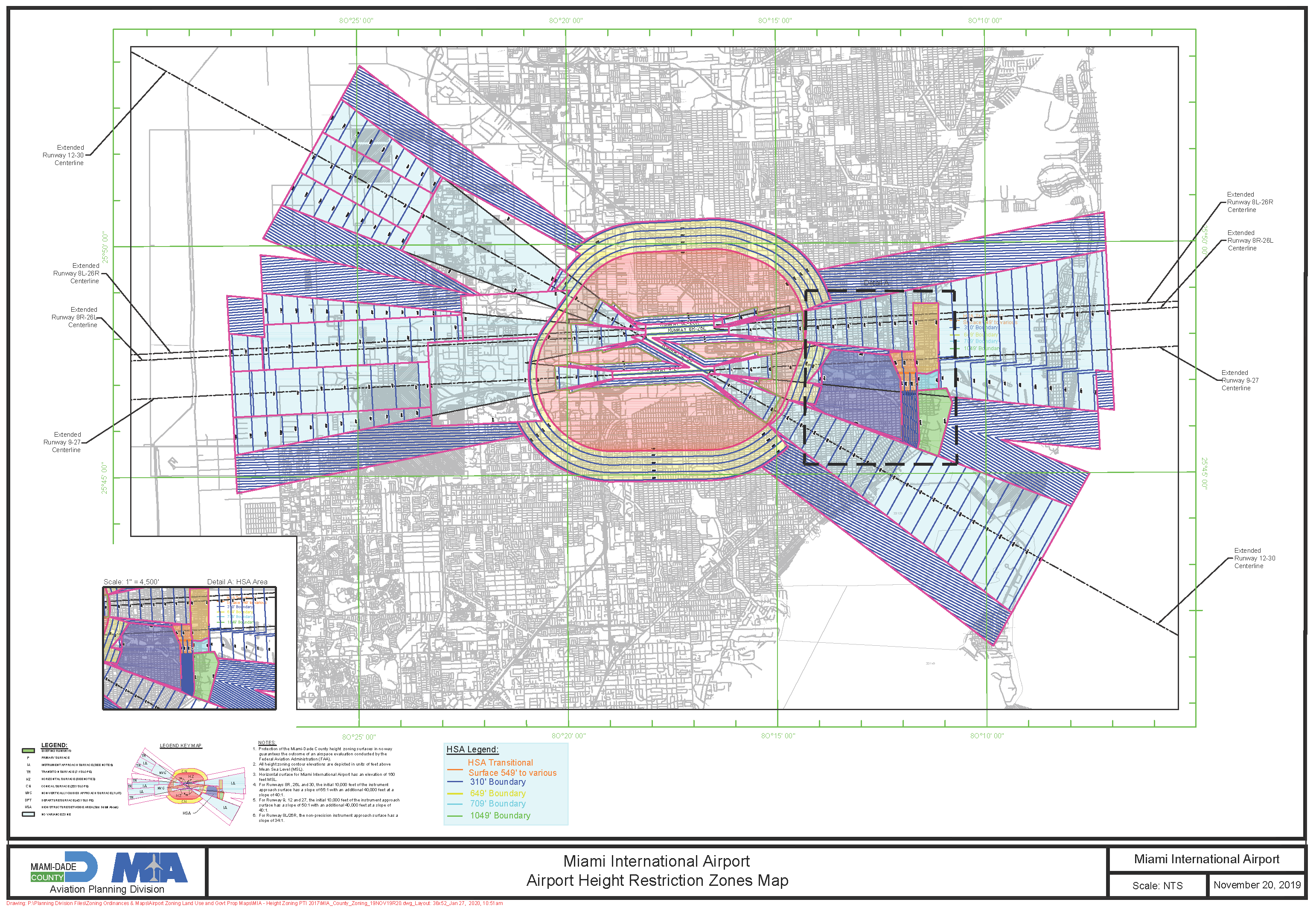
Figure 3. Miami International Airport - Airport Heights Restriction Areas and MIA-HSA
(D)
Height Variance Eligible Area. Figure 4 depicts the Miami International Airport - Height Variance Eligible Area (MIA-HVEA).
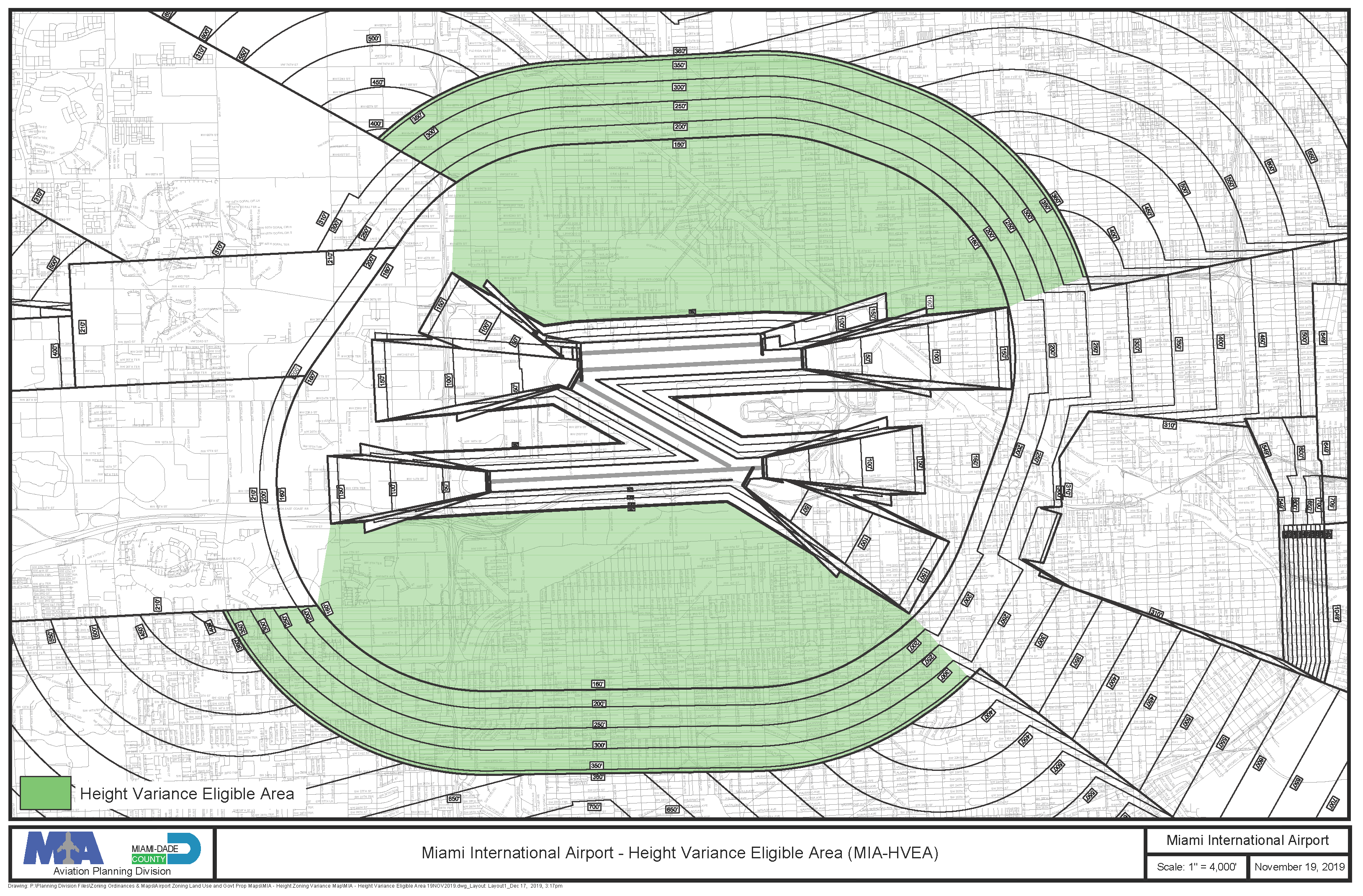
Figure 4. Miami International Airport - Height Variance Eligible Area (MIA-HVEA)
(E)
Airspace Review Area. Figure 5 depicts the airspace review area for permanent structures around Miami International Airport.
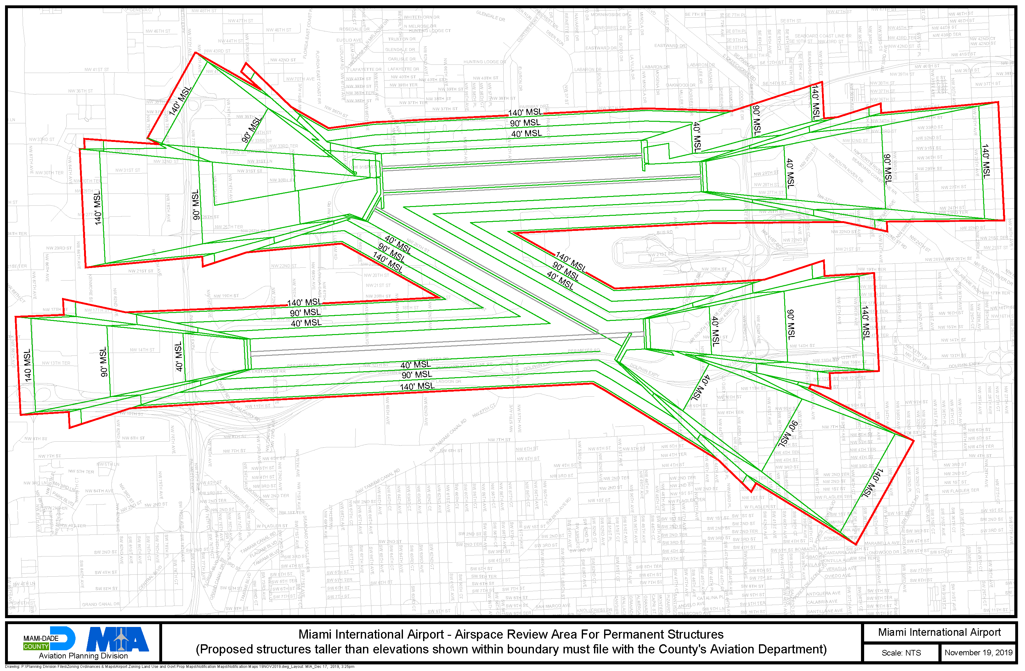
Figure 5. Miami International Airport - Airspace Review Area for Permanent Structures
(Ord. No. 19-112, § 2, 11-19-19)
Sec. 33-339. - Miami Executive Airport (TMB).
(A)
Non-aviation uses permitted on properties zoned GP at TMB. The minimum and maximum of land area devoted to particular non-aviation uses for those parcels designated as GP on Figure 6, full-scale copies of which are on file with MDAD and the Department, shall be as follows:
TMB Non-Aviation Uses Area (±43 Acres)
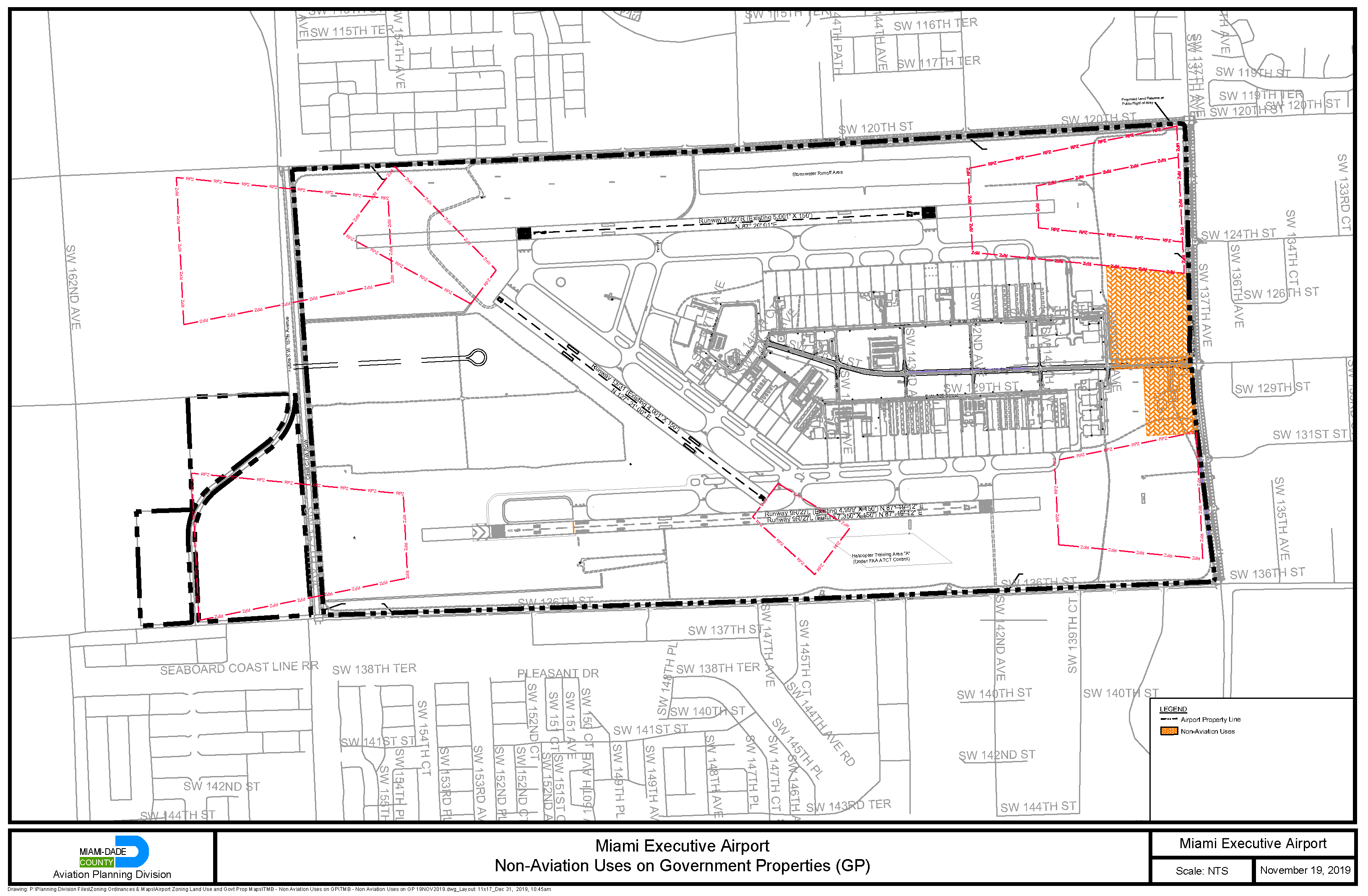
Figure 6. Miami Executive Airport - Non-Aviation Uses on GP Properties
(B)
Land Use and Noise Compatibility Restriction Zones at TMB. Figure 7 depicts the land use and noise compatibility restriction zones for Miami Executive Airport.
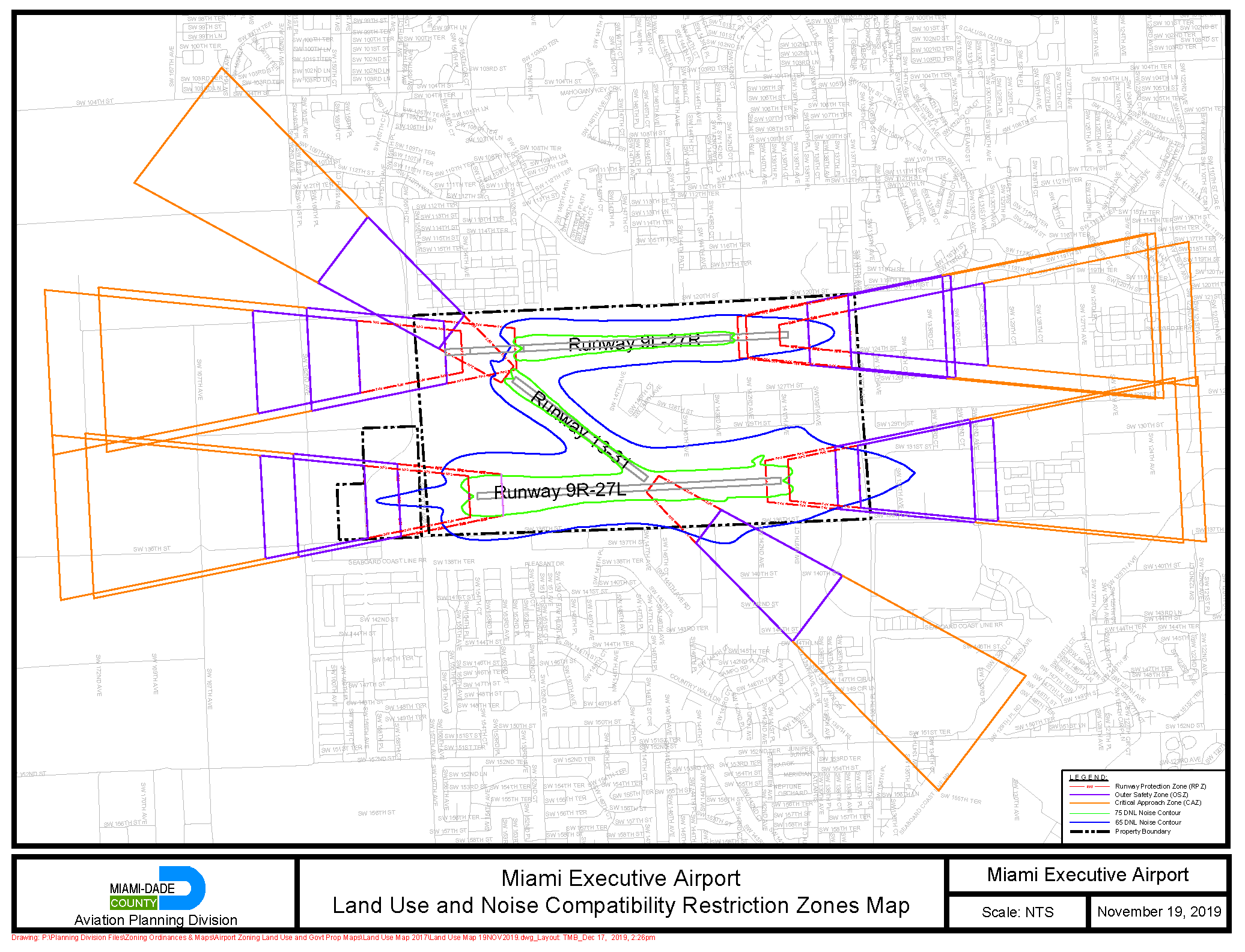
Figure 7. Miami Executive Airport - Land Use and Noise Compatibility Restriction Zones
Map
(C)
Airport Height Restriction Zones. Figure 8 depicts the height restriction zones for Miami Executive Airport.
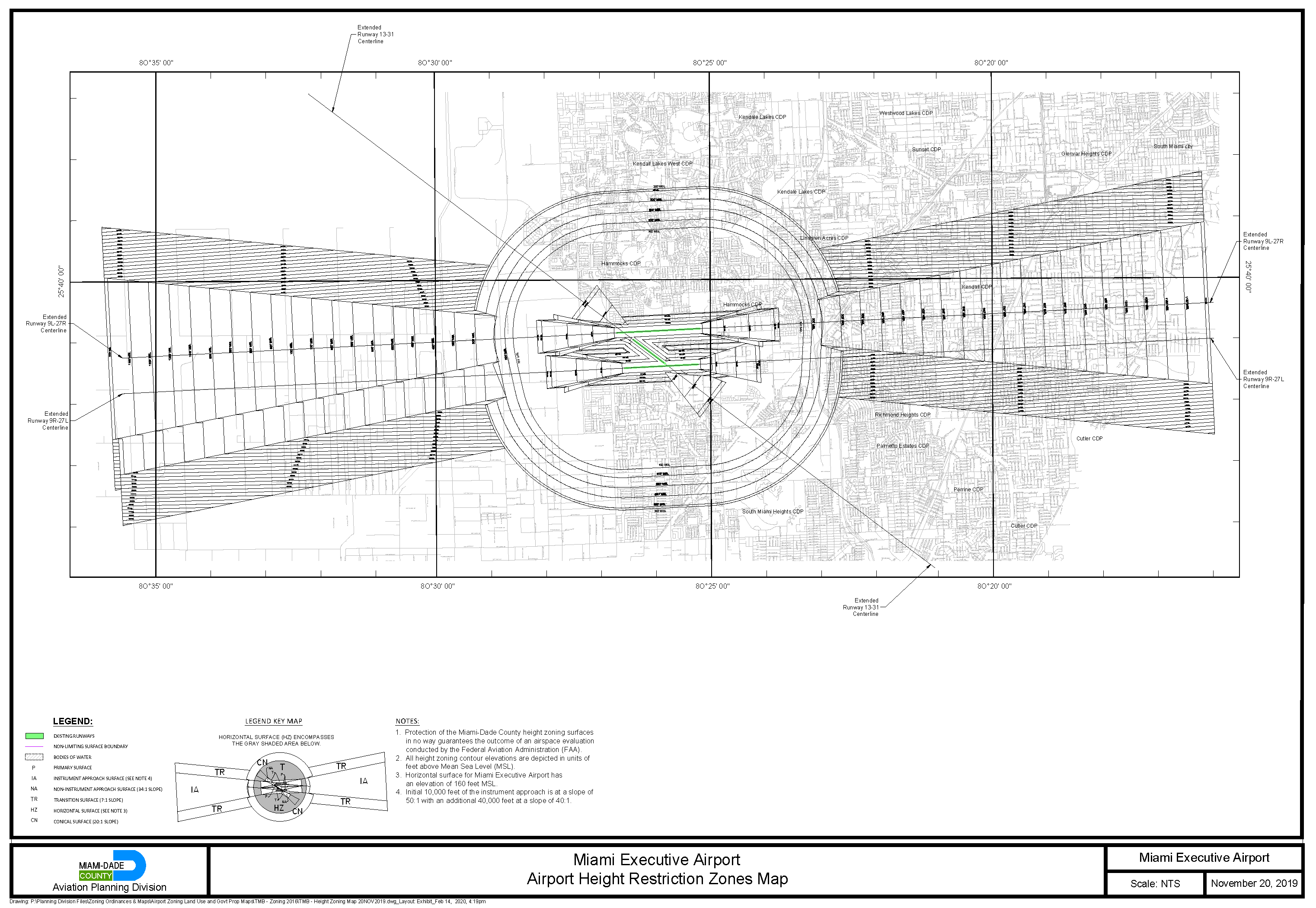
Figure 8. Miami Executive Airport - Airport Heights Restriction Zones
(D)
Height Variance Eligible Area. Figure 9 depicts the Miami Executive Airport - Height Variance Eligible Area (TMB-HVEA).
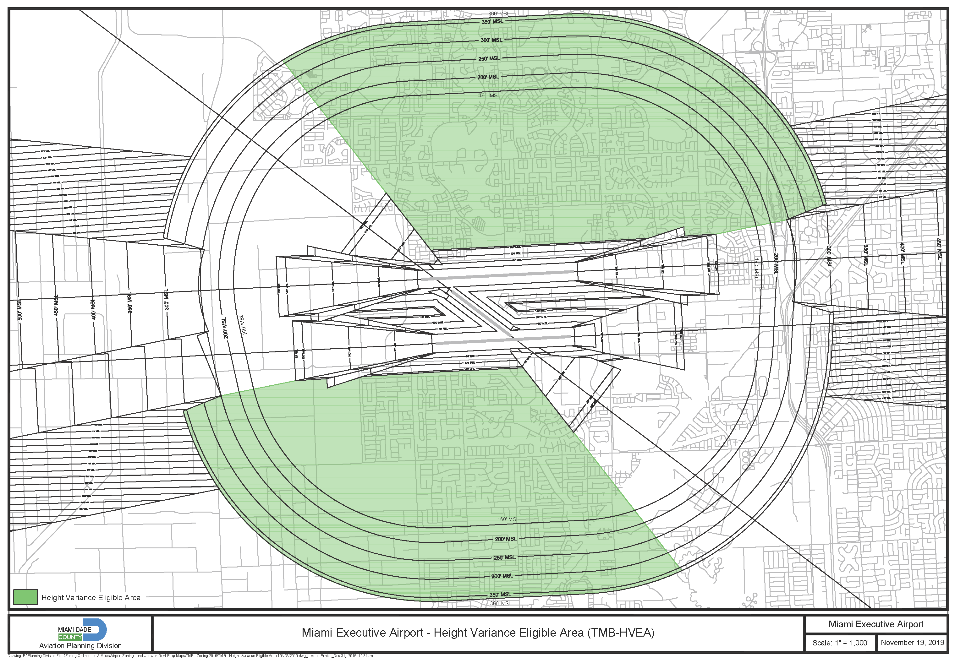
Figure 9. Miami Executive Airport - Height Variance Eligible Area (TMB-HVEA)
(E)
Airspace Review Area. Figure 10 depicts the airspace review area for permanent structures around Miami Executive Airport.
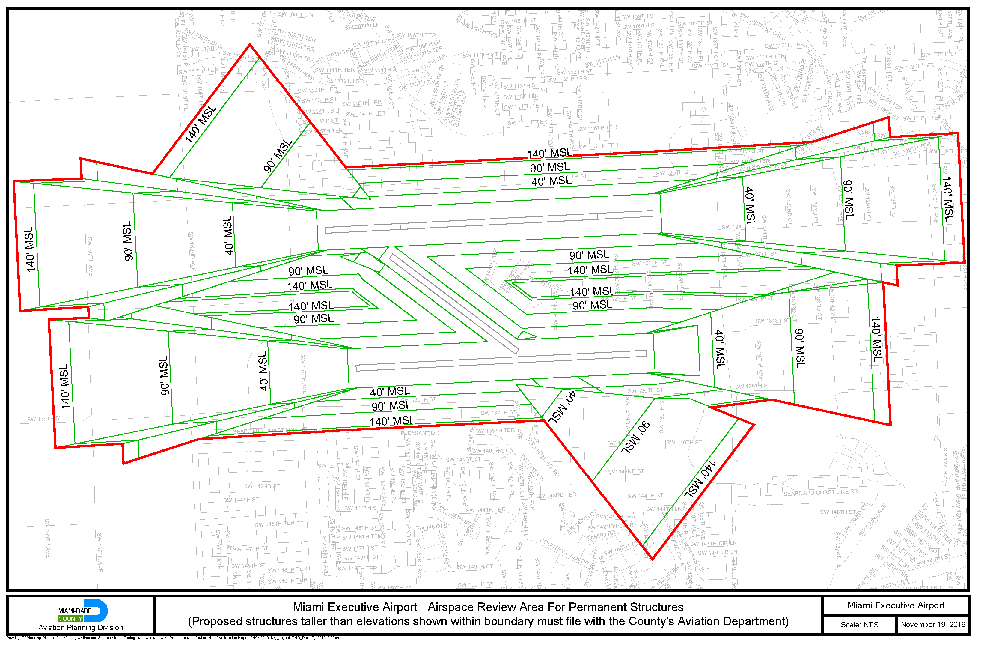
Figure 10. Miami Executive Airport - Airspace Review Area for Permanent Structures
(Ord. No. 19-112, § 2, 11-19-19)
Sec. 33-340. - Miami Opa Locka Executive Airport (OPF).
(A)
Properties zoned GP at OPF. Non-aviation uses on lands designated GP at OPF may be developed in three development zones. The location and intensity of non-aviation uses within each development zone is further limited by the Comprehensive Development Master Plan's Airport Land Use Master Plan map and interpretive text. The minimum and maximum of land area devoted to particular non-aviation uses for those parcels designated as GP on Figure 11, full-scale copies of which are on file with MDAD and the Department, shall be as follows:
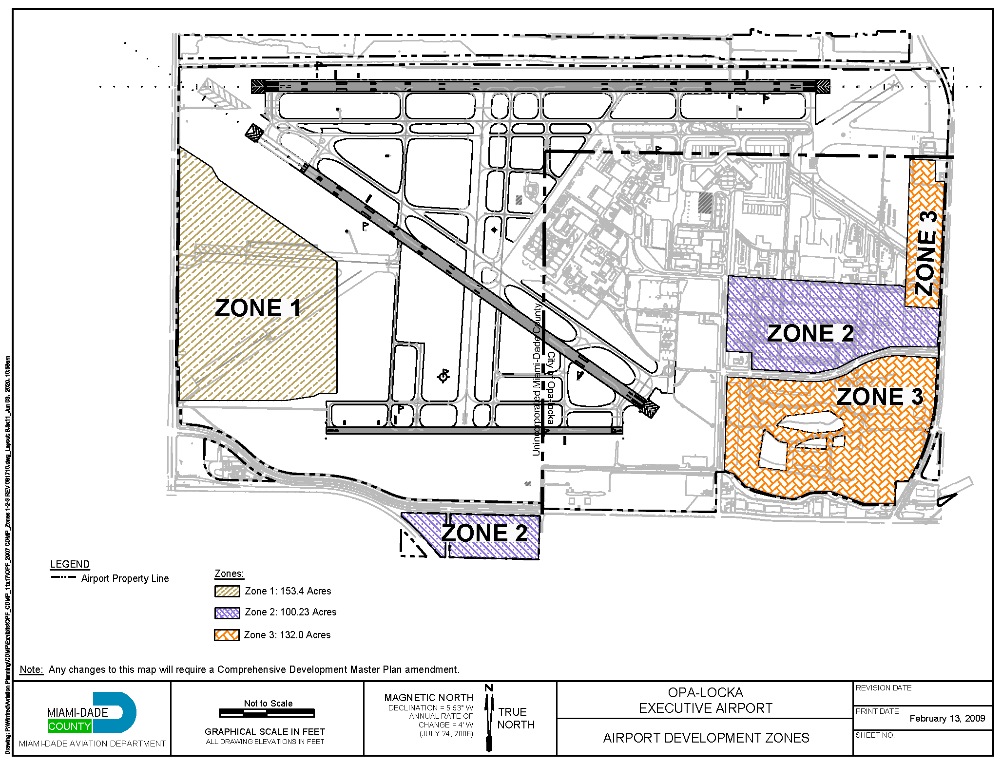
Figure 11. Miami - Opa Locka Executive Airport - Non-Aviation Uses on GP Properties
(B)
Land Use and Noise Compatibility Restriction Zones at OPF. Figure 12 depicts the land use and noise compatibility restriction zones for Miami - Opa Locka Executive Airport.
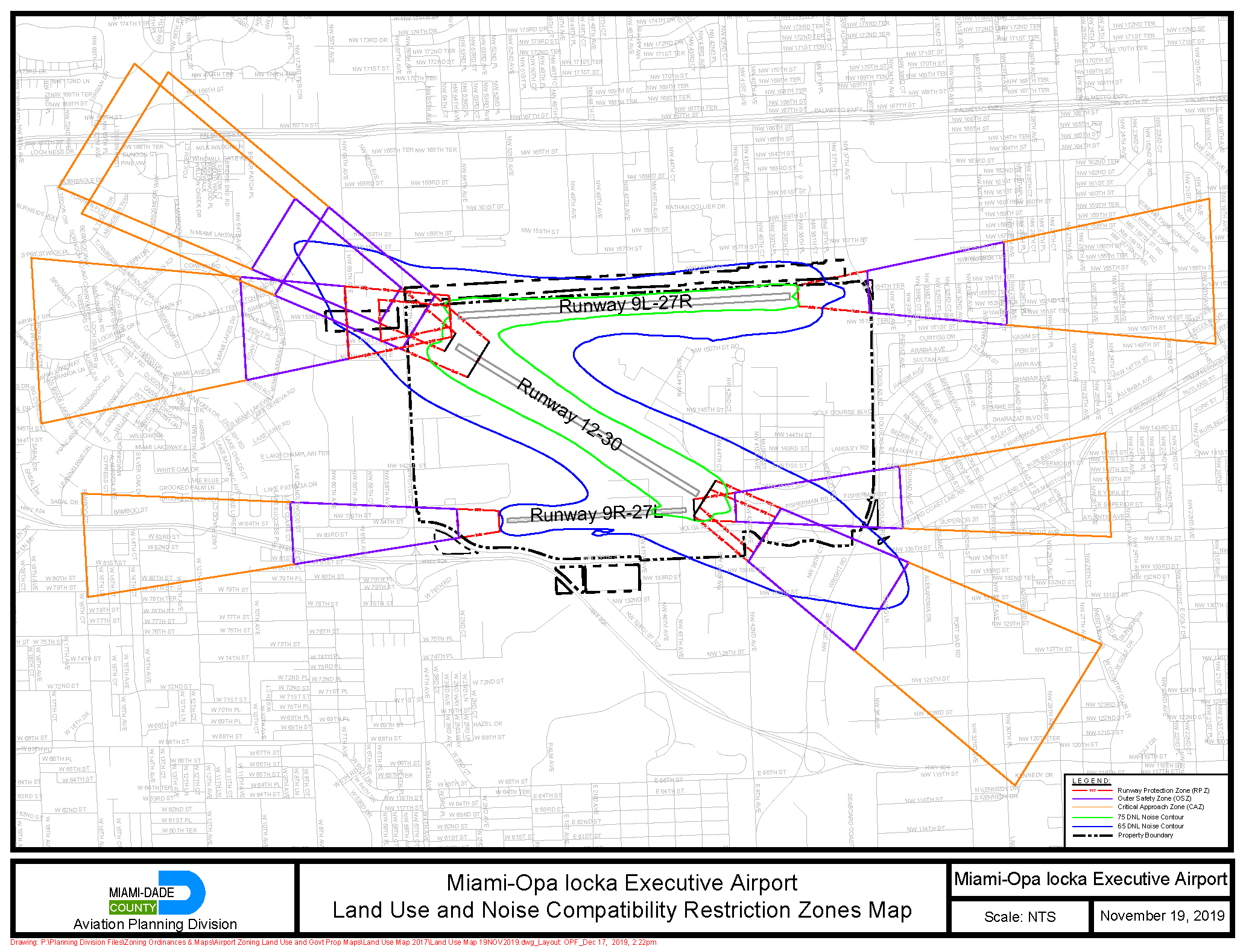
Figure 12. Miami - Opa Locka Executive Airport - Land Use and Noise Compatibility
Restriction Zones
(C)
Airport Heights Restriction Zones. Figure 13 depicts the airport heights restriction zones for Miami - Opa Locka Executive.
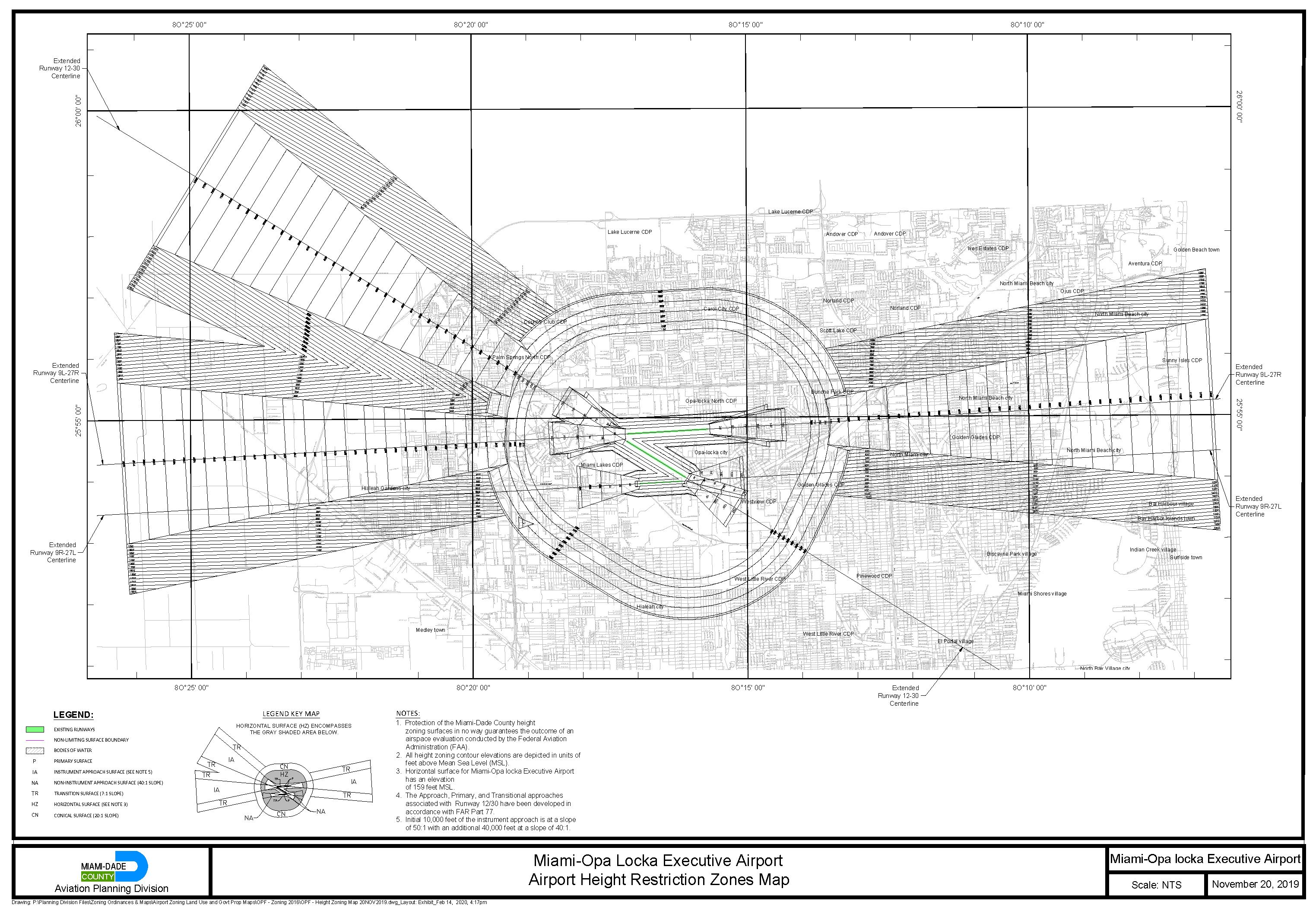
Figure 13. Miami - Opa Locka Executive Airport - Airport Heights Restriction Zones
(D)
Height Variance Eligible Area. Figure 14 depicts the Opa Locka Executive Airport - Height Variance Eligible Area (OPF-HVEA).
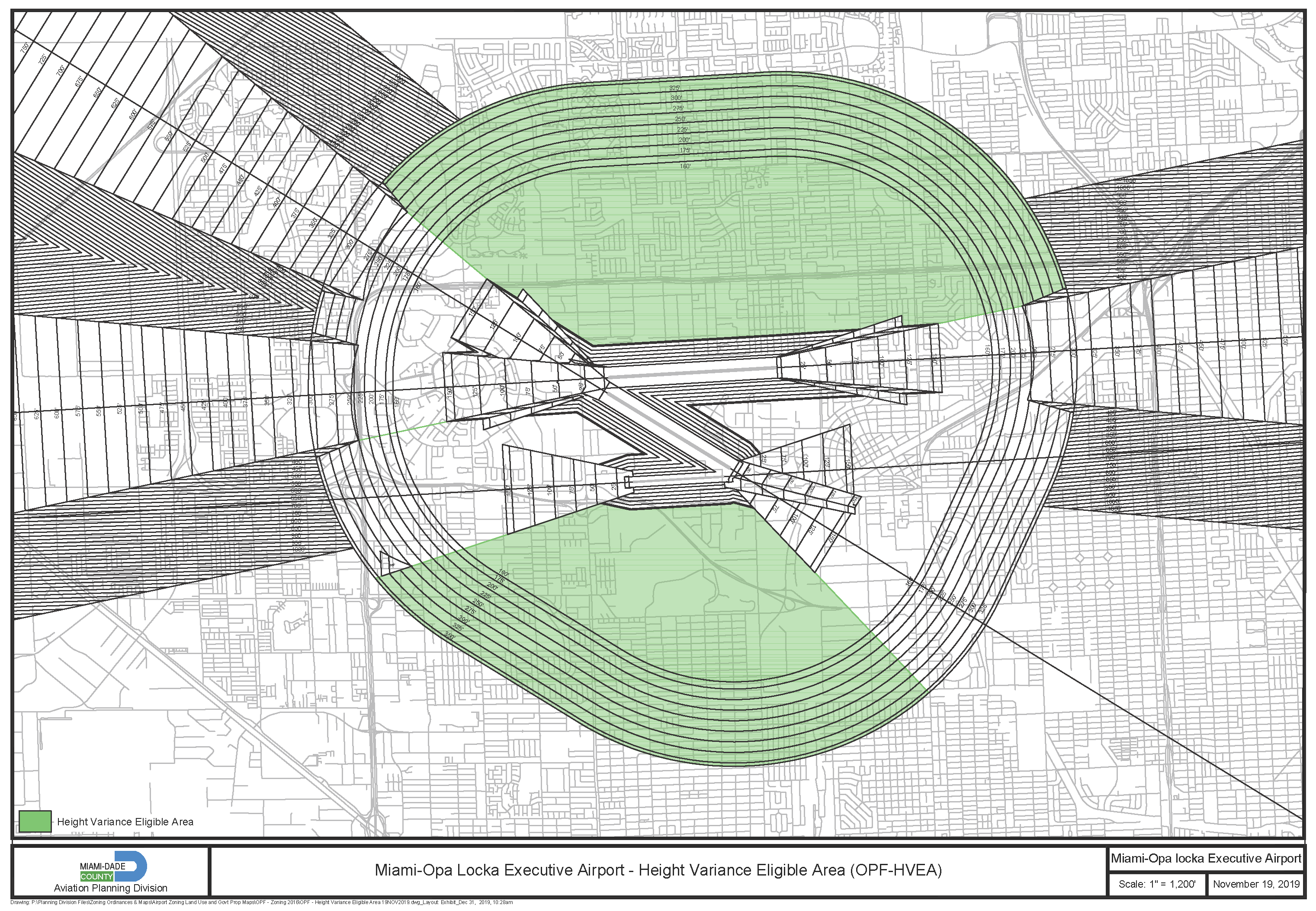
Figure 14. Opa Locka Executive Airport - Height Variance Eligible Area (OPF-HVEA)
(E)
Airspace Review Area. Figure 15 depicts the airspace review area for permanent structures around Miami - Opa Locka Executive Airport.
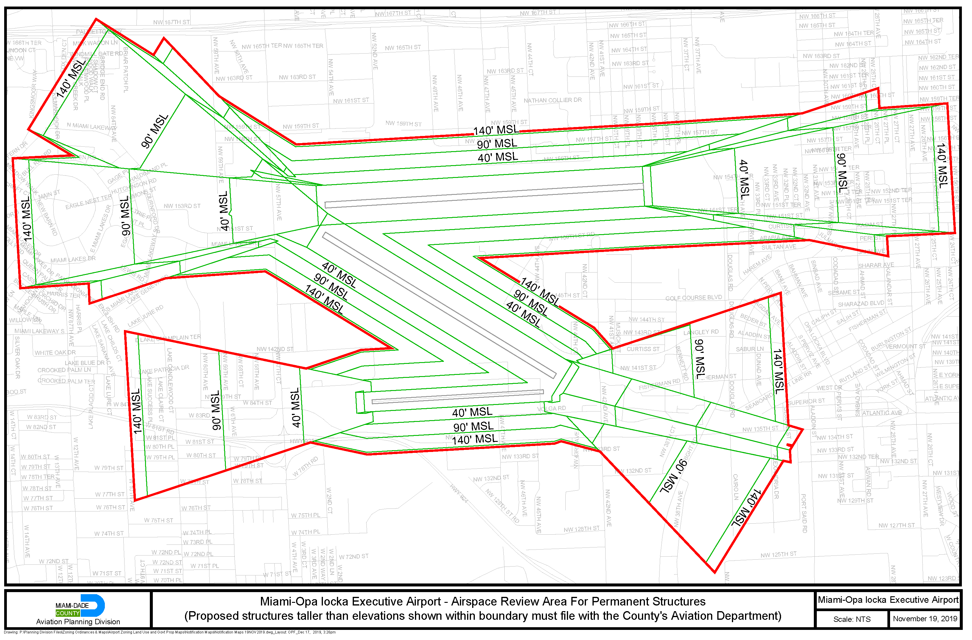
Figure 15. Miami - Opa Locka Executive Airport - Airspace Review Area for Permanent
Structures
(Ord. No. 19-112, § 2, 11-19-19)
Sec. 33-341. - Miami Homestead General Aviation Airport (X51).
(A)
Land Use and Noise Compatibility Restriction Zones at X51.
(1)
Figure 16 depicts the land use and noise compatibility restriction zones for Miami Homestead General Aviation Airport:
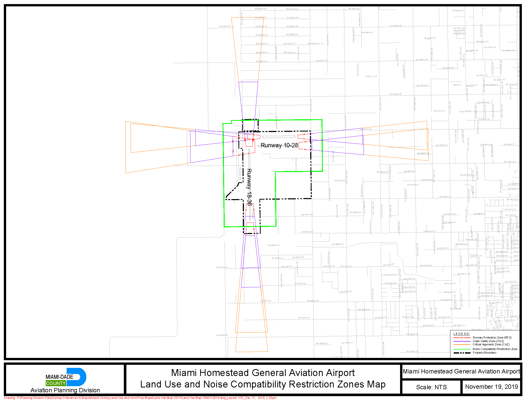
Figure 16. Miami Homestead General Aviation Airport - Land Use and Noise Compatibility
Restriction Zones
(B)
Airport Height Restriction Zones. Figure 17 depicts the airport height restriction zones for Miami Homestead General Aviation Airport.
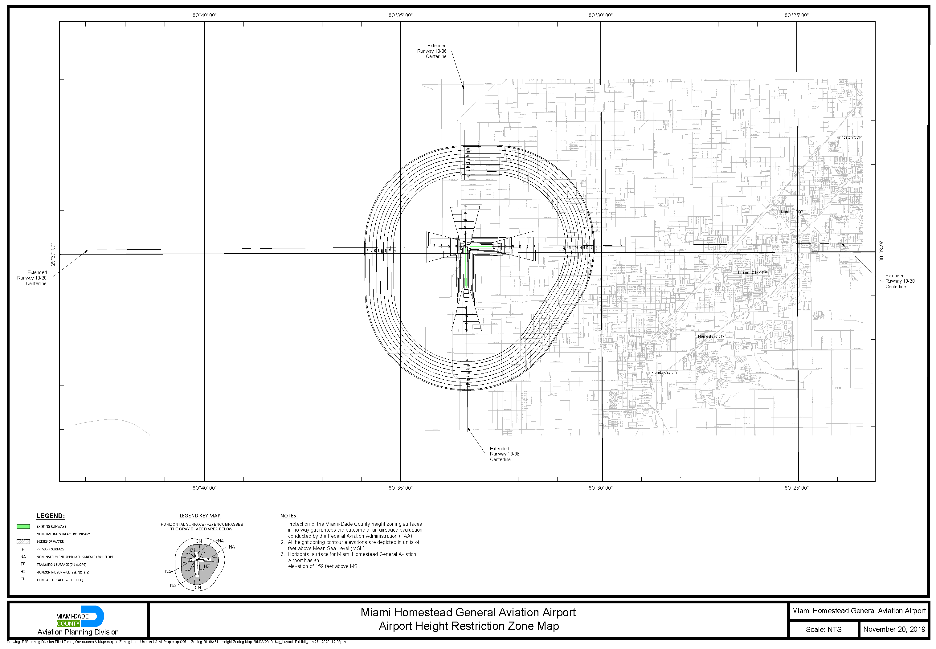
Figure 17. Miami Homestead General Aviation Airport - Airport Heights Restriction
Zones
(C)
Height Variance Eligible Area. Figure 18 depicts the Miami Homestead General Aviation Airport - Height Variance Eligible Area (X51-HVEA).
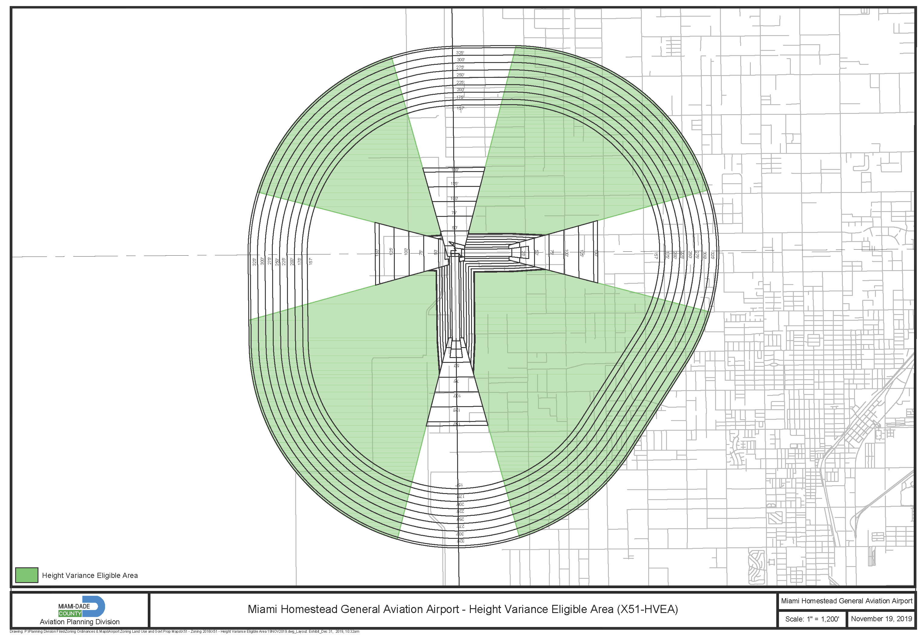
Figure 18. Miami Homestead General Aviation Airport - Height Variance Eligible Area
(X51-HVEA)
(D)
Airspace Review Area. Figure 19 depicts the airspace review area for permanent structures around Miami Homestead General Aviation Airport.
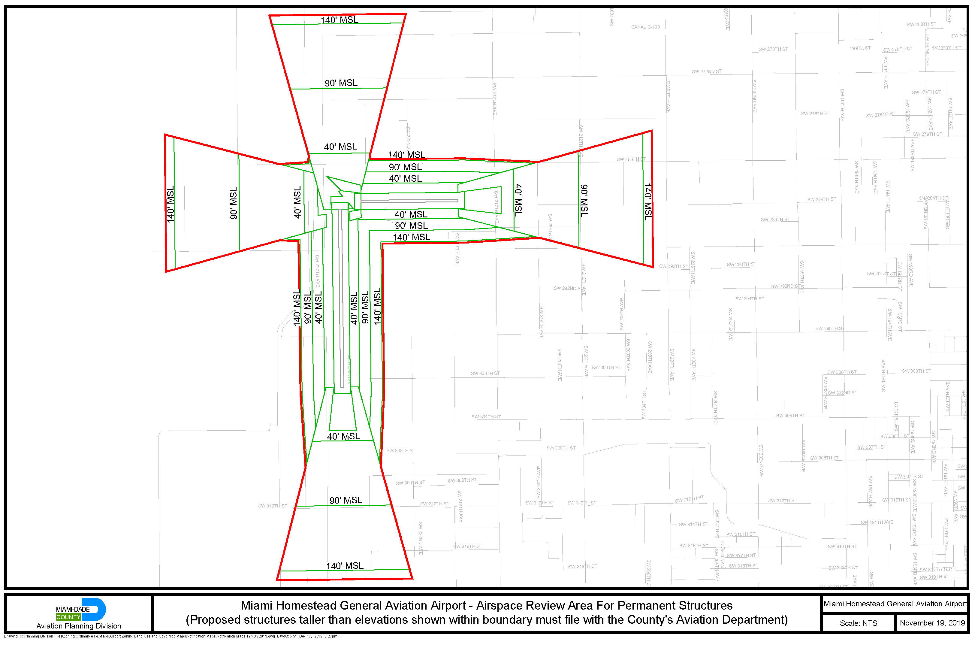
Figure 19. Miami Homestead General Aviation Airport - Airspace Review Area for Permanent
Structures
(Ord. No. 19-112, § 2, 11-19-19)