
Miami Dade County Unincorporated
City Zoning Code
City Zoning Code
ARTICLE XXXIIIJ
NARANJA COMMUNITY URBAN CENTER DISTRICT53
Editor's note— Ord. No. 06-11, § 1, adopted Jan. 24, 2006, repealed sections 33-284.67—33-284.74, and replaced them with new sections 33-284.67—33-284.71. Section 2 of said ordinance renumbered former section 33-284.76 as new section 33-284.72. Former sections 33-284.67—33-284.74 pertained to similar material and derived from Ord. No. 04-217, §§ 2—9, adopted Dec. 2, 2004; Ord. No. 05-145, §§ 1—3, adopted July 7, 2005.
Sec. 33-284.66.- Purpose, intent and applicability.
1.
The Comprehensive Development Master Plan (CDMP) contains directives to promote urban centers in places where mass transit, roadways, and highways are highly accessible. The CDMP provides for three types of urban centers: community (CUC), metropolitan (MUC) and regional (RUC). CUCs are a mechanism by which those CDMP directives can be addressed, because CUCs are compact, mixed-use, and pedestrian-friendly areas. In the Naranja CUC area these CDMP directives are intended to be achieved by the following means:
A.
allocating development intensities within the Naranja CUC according to proximity to mass transit, and by creating Core, Center and Edge sub-districts to allocate the various development intensities within the CUC; and
B.
by organizing an interconnected network of tree-lined streets and sidewalks to improve pedestrian access to transit, jobs, and shopping; and
C.
by providing for open space with specific square, green and/or plaza locations, and by shaping the way buildings front onto open space and streets.
2.
The regulations contained in this chapter and Chapter 18-A, Code of Miami-Dade County, Florida, shall apply to this article, except as otherwise added to or modified herein.
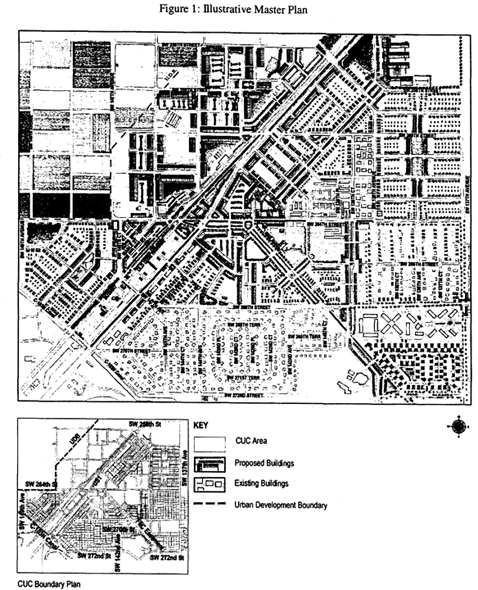
3.
The Illustrative Plan (Figure 1), shall be used to assist in interpreting this article. Where there is conflict between the Illustrative Plan and the text of this article, the text shall govern.
4.
The boundaries shown in Figure 1 illustrate the Naranja CUC Boundary Plan and are generally described as follows: from the northwest corner of the intersection of SW 137 Avenue and SW 272 Street, north along the west side of SW 137 Avenue to the south side of SW 256 Street, then west along the south side of SW 256 Street, then west along the south side of SW 256 Street to the Urban Development Boundary (UDB) line, as of January 1, 2015, then south and west along the UDB to the centerline of SW 149 Avenue, then south along the centerline of SW 149 to the C-103N canal, then southeast along the canal to the north side of SW 272 Street to the west side of SW 142 Avenue to the south side of SW 270 Street, then east along the north side of SW 270 Street to the east side of the Naranja Canal easement, then southeast and south along the east side of the Naranja Canal easement to the north side of SW 272 Street, then east along the north side of SW 272 Street to the west side of SW 137 Avenue. The exact location of the UDB line is on file with the Department of Regulatory and Economic Resources or its successor department. An approximate delineation of the UDB line is depicted in the Regulating Plans. Any amendment to the CDMP resulting in a movement of the UDB line following the effective date of this ordinance shall be followed by an amendment to this section of the code to reflect the new UDB line or the westernmost boundaries of the NCUC in compliance with the half-a-mile radius CDMP requirement for Community Urban Centers.
Full scale maps and a legal description of the boundaries of the Illustrative Plan presented in Figure 1, as well as the Regulating Plans and Street Development Parameters figures, are on file with the Department.
5.
No provision in this article shall be applicable to any property except lands lying within the boundaries of the Naranja Community Urban Center District as described herein. No property lying within the boundaries of the Naranja Community Urban Center shall be entitled to the uses or subject to the regulations provided in this article until an application for a district boundary change to the Naranja Community Urban Center District has been heard and approved in accordance with the provisions of this chapter.
(Ord. No. 04-217, § 1, 12-2-04; Ord. No. 15-65, § 1, 7-14-15; Ord. No. 16-91, § 4, 9-7-16)
Sec. 33-284.67. - Naranja Community Urban Center District (NCUC) Requirements.
Except as provided herein, all developments within the NCUC shall comply with the requirements provided in Article XXXIII(K), Standard Urban Center District Regulations, of this Code.
(Ord. No. 06-11, § 1, 1-24-06)
Sec. 33-284.68. - Uses.
Except as provided herein, all permitted, conditionally permitted, and temporary uses within the NCUC shall comply with Section 33-284.83 of this Code.
A.
Permitted Uses. In addition to the uses provided in Section 33-284.83, the following shall be permitted:
1.
In the Industrial District (ID) area, all uses permitted in the IU-2 zoning district if approved after public hearing pursuant to Section 33-311(A)(3) of this Code.
2.
In the Mixed-Use Optional (MO) area: Live-work units.
3.
In the Market District (MD) area:
a.
outdoor produce markets as a permanent use and not subject to restrictions on temporary uses set forth in Section 33-284.83(A)(5), and
b.
all uses permitted in the Mixed-Use Corridor (MC) except for residential.
(Ord. No. 06-11, § 1, 1-24-06; Ord. No. 15-65, § 2, 7-14-15)
Sec. 33-284.69. - Reserved.
Editor's note— Ord. No. 16-91, § 5, adopted Sept. 7, 2016, repealed § 33-284.69, which pertained to regulating plans and derived from Ord. No. 06-11, § 1, adopted Jan. 24, 2006; Ord. No. 07-96, § 1, adopted July 10, 2007; Ord. No. 15-65, § 3, adopted July 14, 2015; and Ord. No. 16-41, § 1, adopted April 19, 2016.
Sec. 33-284.70. - Building Placement and Street Type Development Parameters.
A.
All new development and redevelopment within the NCUC shall comply with the Building Placement Standards as provided in Section 33-284.85 of this Code. Outdoor produce markets in the Market District shall comply with the Building Placement Standards for Civic Uses in Section 33-284.85 of this Code; all other development in the Market District shall comply with the Building Placement Standards for Mixed-Use, Multi-Family as provided in Section 33-284.85.
B.
All new development and redevelopment within the NCUC shall comply with the Streets, Service Roads and Utilities standards as provided in Section 33-284.86(C), except as provided herein:
C.
The following setbacks shall be required where a Building Placement Standard in Section 33-284.85 of this Code refers to a Frontage Table:
D.
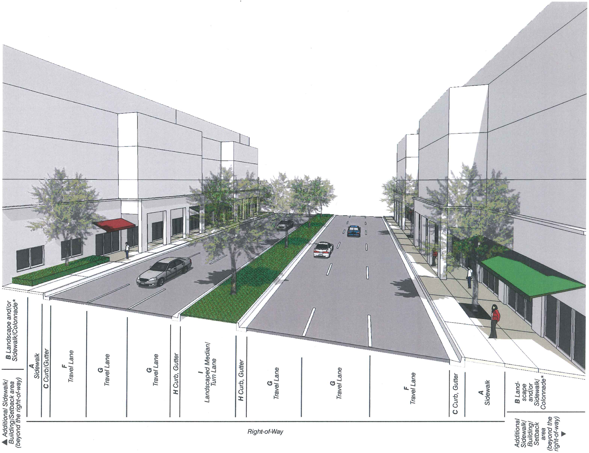
Street Types Development Parameters. U.S. 1
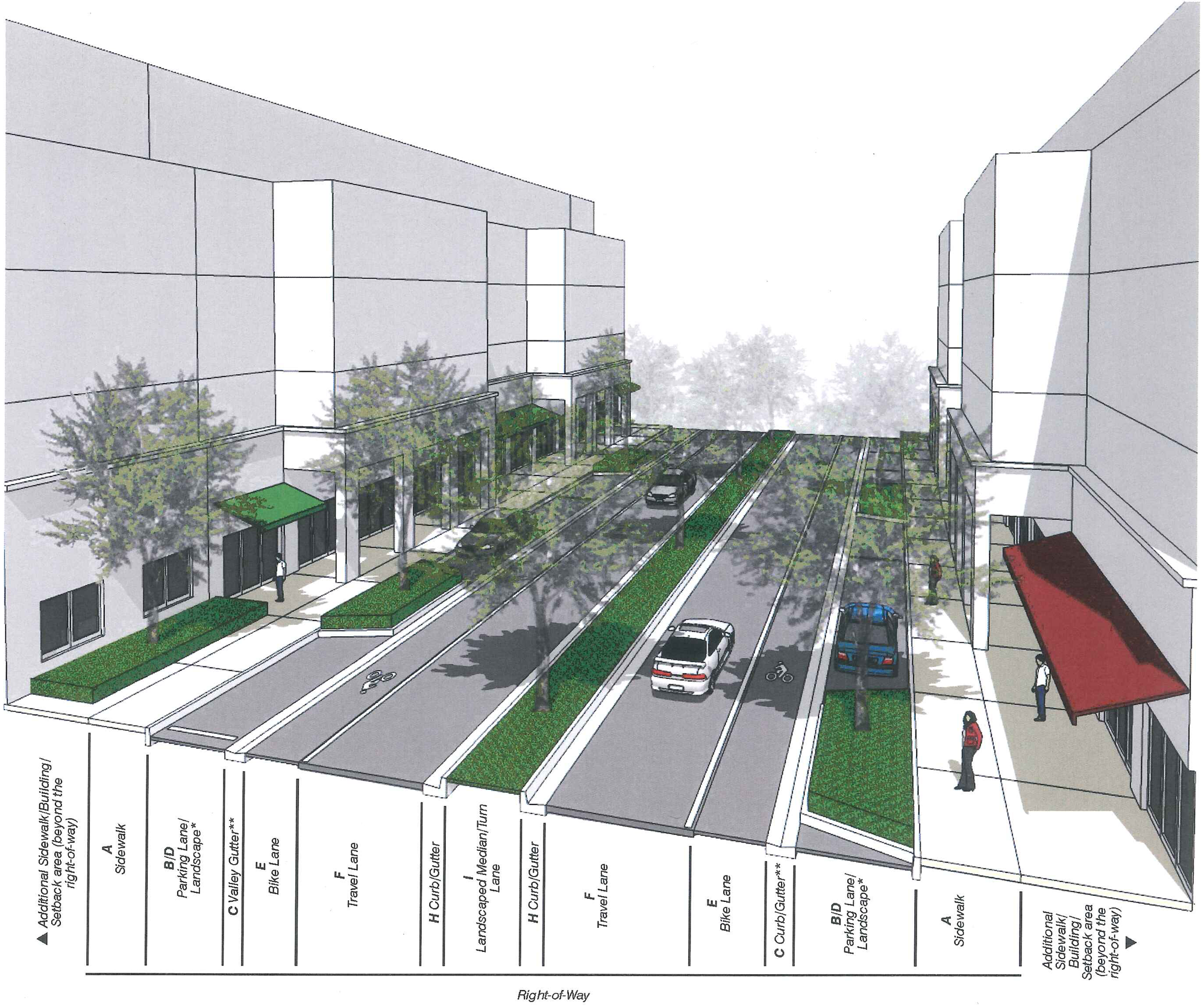
* Refer to column B in Street Types Table for required landscape elements.
Main Street
* Refer to column B in Street Types Table for required landscape elements.
** Curb and gutter between the sidewalk and parking/travel lanes may be utilized in place of the valley gutter illustrated.
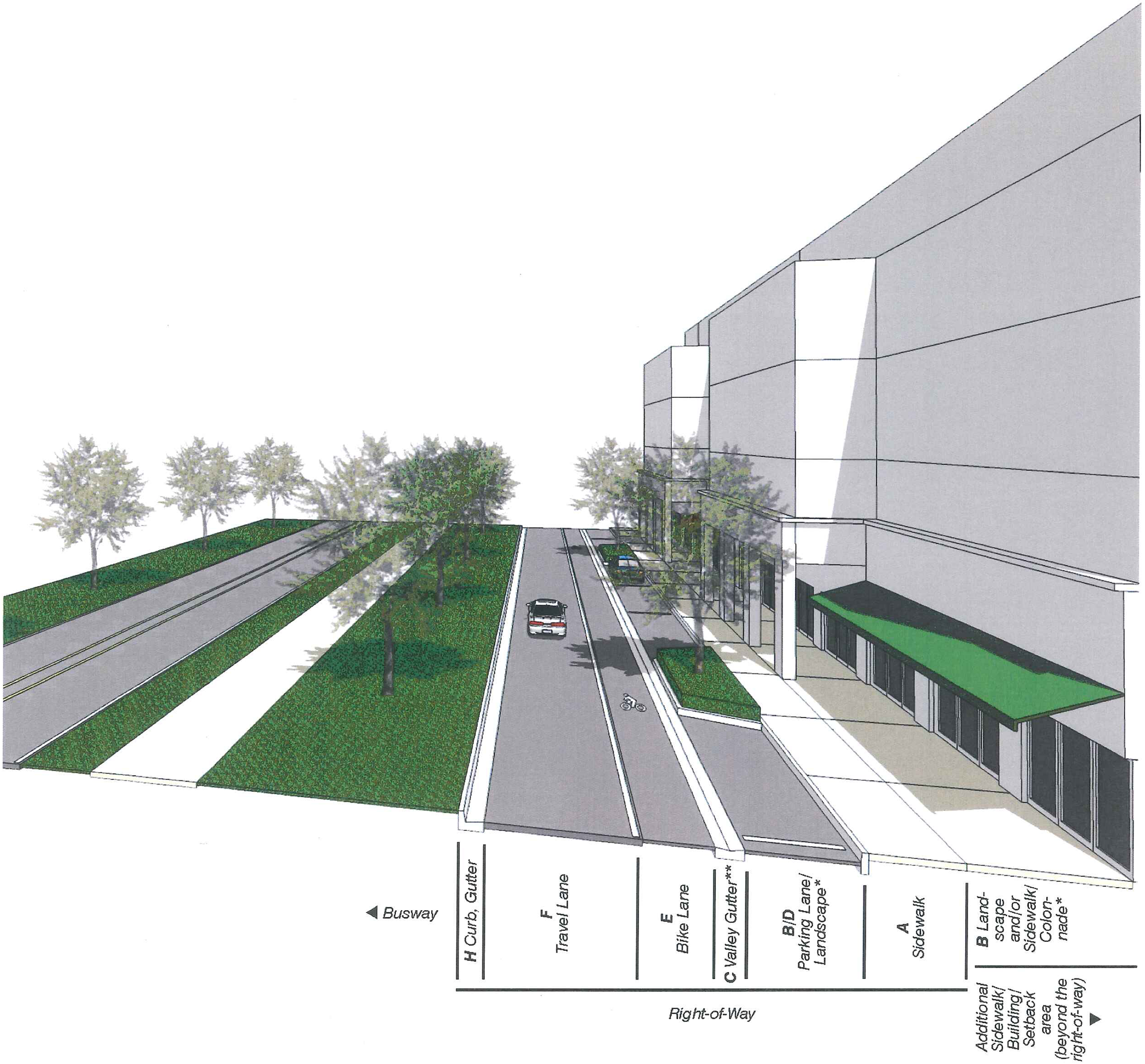
Busway Frontage
* Refer to column B in Street Types Table for required landscape elements.
** Curb and gutter between the sidewalk and parking/travel lanes may be utilized in place of the valley gutter illustrated.
Footnotes:
a.
Landscape area is exclusive of the minimum sidewalk width.
b.
Street trees shall have a minimum caliper of six (6) inches at time of planting.
c.
Permanent irrigation is required.
d.
Tree grates shall have a minimum area of twenty-four (24) square feet; tree planters shall have a minimum area of thirty-two (32) square feet; continuous landscape strips shall have a minimum width of six (6) feet in the Center Sub-district, eight (8) feet in the Edge Sub-district.
e.
In all Sub-districts, curbs and gutters shall be provided at all intersections and roadway edges of arterials, boulevards and Main Street; in Core and Center Sub-districts, curbs and gutters shall be provided at all intersections and roadway edges of minor streets.
g.
Bike lanes shall be four (4) feet in width when adjacent to curb or swale; five (5) feet in width when adjacent to a parking lane.
h.
The minimum required width of one-lane/one-way travel lanes shall be determined by the Department of Public Works and Waste Management or its successor and Fire Rescue Department or its successor on a case-by-case basis during the Administrative Site Plan Review process (ASPR).
i.
The use of permeable materials to pave private street sidewalks, on-street parking, and vehicular drives is permitted. Use of permeable materials to pave public street sidewalks, on-street parking and vehicular drives shall require approval from the Director of the Department of Public Works and Waste Management.
(Ord. No. 06-11, § 1, 1-24-06; Ord. No. 07-96, § 2, 7-10-07; Ord. No. 15-65, § 4, 7-14-15)
Sec. 33-284.71. - Reserved.
Editor's note— Ord. No. 15-65, § 5, adopted July 14, 2015, repealed § 33-284.71, which pertained to general requirements. See Code Comparative Table for complete derivation.
Sec. 33-284.72. - Nonconforming structures, uses, and occupanies.
Nonconforming structures, uses, and occupancies shall be governed by the provisions of section 33-284.89.2 of this chapter.
(Ord. No. 04-217, § 11, 12-2-04; Ord. No. 05-145, § 4, 7-7-05; Ord. No. 06-11, § 2, 1-24-06; Ord. No. 15-65, § 6, 7-14-15)
Sec. 33-284.75. - Conflicts with other chapters and regulations.
This article shall govern in the event of conflicts between this article and other zoning, subdivision, or landscape regulations of this Code.
(Ord. No. 04-217, § 10, 12-2-04)
Sec. 33-284.76. - Reserved.
Editor's note— See Editor's note at article XXXIII(J).