
Miami Dade County Unincorporated
City Zoning Code
City Zoning Code
ARTICLE XXXV
HOMESTEAD AIR RESERVE BASE ZONING55
Editor's note— Ord. No. 17-06, § 2, adopted Jan 24, 2017, changed the title of Art. XXXV from "Homestead Air Force Base Zoning" to "Homestead Air Reserve Base Zoning."
Editor's note— Article XXXV, §§ 33-292—33-301, is derived from Ord. No. 68-33, § 1, adopted May 21, 1968. This ordinance amended said sections to read as herein set out. Formerly said sections pertaining to similar subject matter were derived from Ord. No. 57-21, §§ 2—12, adopted Oct. 22, 1957.
Sec. 33-291.1.- Intent.
In accordance with Chapter 333, Florida Statutes, and Policies LU-4H and AV-7C of the Comprehensive Development Master Plan (CDMP), it is the intent of the Board of County Commissioners to establish the Homestead Air Reserve Base (HARB) zoning regulations to enhance and promote the compatibility of adjacent land uses and development with the HARB and the protection of HARB operations and activities. This article regulates land uses around the HARB through Accident Potential Zones, Noise Contour Zones, and Airport Height Zones designated around the HARB's perimeter.
(Ord. No. 17-06, § 2, 1-24-17)
Sec. 33-291.2. - Applicability and enforcement.
The regulations in this article shall apply outside the boundaries of HARB, within the unincorporated area of Miami-Dade County, and as minimum standards within the incorporated areas of the County. Enforcement of this article shall be the responsibility of the County in the unincorporated area and the responsibility of the municipalities in the incorporated areas. It is provided that municipal regulations adopted prior to February 3, 2017, are deemed to be in compliance with this article.
(Ord. No. 17-06, § 2, 1-24-17)
Sec. 33-292. - Definitions.
As used in this article, unless the context otherwise requires, the following definitions shall apply:
(1)
Airport is the Homestead Air Reserve Base Airport, the boundaries of which are established by the United States government.
(2)
Airport hazard is an obstruction to aircraft navigation that affects the safe and efficient use of navigable airspace or the operation of planned or existing air navigation and communication facilities.
(3)
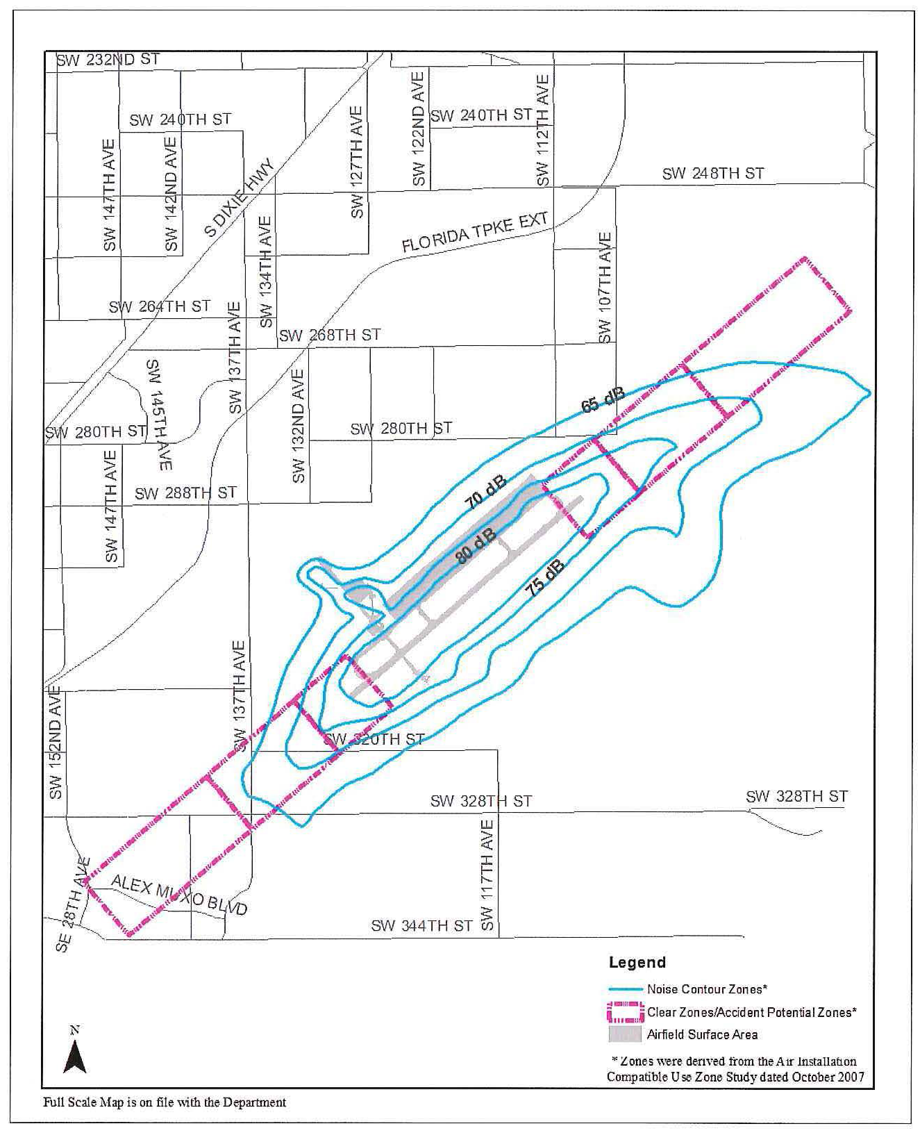
Airport Land Use Restriction Area is the land area encompassed within the Accident Potential Zones and Noise Contour Zones as depicted on Figure 2 of section 33-295 of this article. A full scale map of the boundaries of the Airport Land Use Restriction Area presented in Figure 2 is on file with the Department.
(4)
Nonconforming use is any structure, tree, or use of land which was legally established but which does not conform to this article.
(5)
Person is any individual, firm, co-partnership, corporation, company, association, joint stock association or body politic, and includes any trustee, receiver, assignee or other similar representative thereof.
(6)
Structure is any object constructed or installed by man, including but without limitation, buildings, towers, smokestacks, signs, utility poles and overhead transmission lines.
(7)
Tree is any object of natural growth.
(8)
Landing area is that part of the airfield that is used or intended to be used for landing and taking-off of aircraft, and the adjacent clear zone.
(9)
Primary surface is that surface which defines the limits of the obstruction clearance requirements in the immediate vicinity of the landing area. This area is entirely within the boundaries of the Airport.
(10)
Accident Potential Zones include the following land areas:
(a)
Clear zone surface is an area that is 3,000 feet wide and that extends outward from each end of the runway, starting at the runway's threshold, for 3,000 feet.
(b)
Accident Potential Zone I (APZ I) is an area that is 3,000 feet wide and that extends outward from each clear zone surface for a distance of 5,000 feet, such that the outer edges of the APZ I are 8,000 feet from the respective runway's thresholds.
(c)
Accident Potential Zone II (APZ II) is an area that is 3,000 feet wide and that extends out 7,000 feet from each APZ I, such that the outer edges of the APZ II are 15,000 feet from the respective runway's thresholds.
(11)
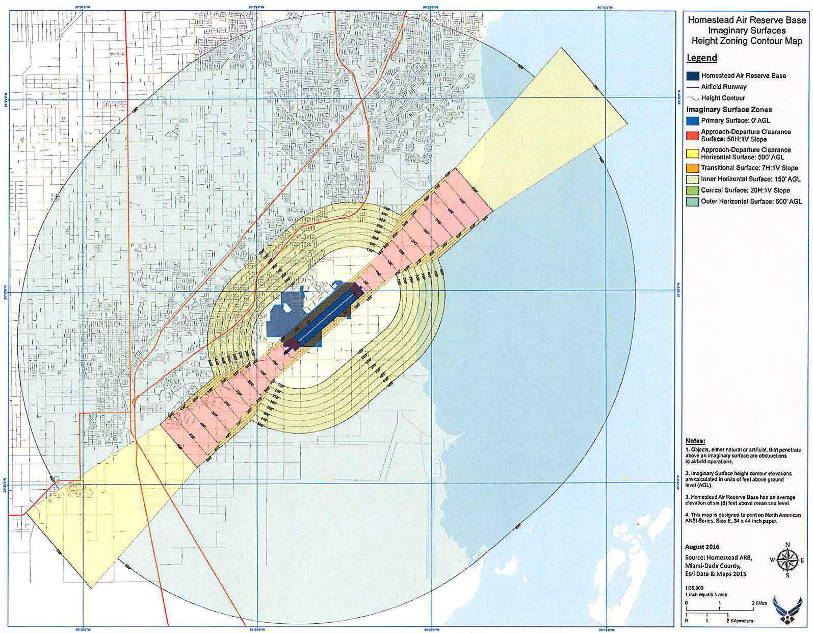
Airport Height Zone shall refer to an approach-departure clearance surface zone, inner horizontal surface zone, conical surface zone, outer horizontal surface zone, and transitional surface zone, as described in, and depicted on Figure 1 in, section 33-29.
(12)
Noise Contour Zones shall refer to those land areas, as depicted on Figure 2 in section 33-295, located within the Noise Contours in which noise exposure is measured at a Day-Night Noise Level (DNL) of 65 decibels (dB) or greater.
(13)
Established airfield elevation is six feet above MSL.
(14)
Airfield reference point is a point or points on the airfield from which certain distances relative to specific criteria referred to in this article are measured. For the purpose of this article, the reference points will be at each end of the runway and on its centerline. These points are described and located in Section 33-293.1
(15)
HARB shall mean Homestead Air Reserve Base.
(16)
Landfill has the same meaning as provided in Section 403.703, Florida Statutes, as such may be amended from time to time.
(17)
MSL or Mean sea level shall mean a tidal datum, as defined by the National Oceanic and Atmospheric Administration, describing the arithmetic mean of hourly local water level heights observed over the National Tidal Datum Epoch.
(Ord. No. 68-33, § 1, 5-21-68; Ord. No. 95-215, § 1, 12-5-95; Ord. No. 98-125, § 21, 9-3-98; Ord. No. 17-06, § 2, 1-24-17)
Sec. 33-293. - Airport height and use restrictions.
This article regulates land uses around the Homestead Air Reserve Base through height limitations and use restrictions based on proximity to the airport.
(Ord. No. 17-06, § 2, 1-24-17)
Editor's note— Ord. No. 17-06, § 2, adopted Jan. 24, 2017, repealed the former § 33-293 and enacted a new § 33-293 as set out herein. The former § 33-293 pertained to establishing airport hazard area and derived from Ord. No. 68-33, ;s 1, adopted May 21, 1968.
Sec. 33-293.1. - Reference points of airport zones.
(1)
Reference points 1 and 2 are related to a primary reference point 250 feet east and 100 feet south of the northwest corner of the N ½ of the NW ¼ of the SW ¼ of the NW ¼ of Township 57 South, Range 39 East, Section 12, Miami-Dade County, Florida, which is the location of the control tower which is also described as being at
Lat
25° - 29′ - 18.9″
Long
80° - 23′ - 39.9″
For the purpose hereof, the elevation of this point is six feet above mean sea level.
(2)
Reference point No. 1 is at the northeast end of the runway and on its centerline. This point is located 1,000 feet from surveying monument HAF-41 on a true bearing of S49°03'29"W. The location of HAF-41 monument is as follows:
N
- 424, 425.21
E
- 708, 243.92
Lat
- 25° - 29′ - 59.808″
Lon
- 80° - 22′ - 07.135″
For the purpose hereof, the elevation of this point is six feet above mean sea level.
(3)
Reference point No. 2 is at the southwest end of the runway and on its centerline. This point is located 1,262.35 feet from surveying monument HAF-25 on a true bearing of 49.321 degrees. The location of HAF-25 monument is as follows:
N
- 415, 609.25
E
- 698, 081.42
Lat
- 25° - 28′ - 32.958″
Lon
- 80° - 23′ - 58.482″
For the purpose hereof, the elevation of this point is six feet above mean sea level.
(Ord. No. 68-33, § 1, 5-21-68; Ord. No. 17-06, § 2, 1-24-17)
Editor's note— Ord. No. 17-06, § 2, adopted Jan. 24, 2017, changed the title of § 33-293.1 from "Reference points of airport hazard area" to "Reference points of airport zones."
Sec. 33-293.2. - Reserved.
Editor's note— Ord. No. 17-06, § 2, adopted Jan. 24, 2017, repealed § 33-293.2, which pertained to division of airport hazard area into zone and derived from Ord. No. 68-33, § 1, adopted May 21, 1968.
Sec. 33-293.3. - Reserved.
Editor's note— Ord. No. 17-06, § 2, adopted Jan. 24, 2017, repealed § 33-293.3, which pertained to zoning map adopted and derived from Ord. No. 68-33, § 1, adopted May 21, 1968 and Ord. No. 95-215, § 1, adopted Dec. 5, 1995.
Sec. 33-294. - Heights limitations.
Except as otherwise provided in this article, any structure which is erected or increased in height, or any tree which is allowed to grow so as to project above the height of the controlling Airport Height Zone, will be considered an airport hazard and in violation of this article.
There is only one runway at Homestead Air Reserve Base. This runway has a true bearing of 49.321 degrees. The magnetic declination at the Homestead Air Reserve Base is 6.2 degrees West, for a magnetic runway bearing of 55.521 degrees. As depicted on Figure 1, a height limitation within each surface is hereby established which will provide a clear space above the entire area of the established Airport Height Zone. Figure 1 consists of a map entitled "Homestead Air Reserve Base Imaginary Surfaces - Height Zoning Contour Map," as prepared by Homestead Air Reserve Base, dated August 2016, reflecting the defined Airport Height Zones. A full scale copy of Figure 1 is on file with the Department and the Homestead Air Reserve Base. The Airport Height Zones are defined as follows:
(a)
Approach-departure clearance surface is an imaginary plane symmetrical about the runway centerline extended, beginning as an inclined plane (known as the glide angle), the base of which is 2,000 feet wide and begins 200 feet beyond each end of the ultimate primary surface at the centerline elevation of the runway threshold (established airfield elevation) and extends outward and upward on a ratio of 50 feet horizontal to 1 foot vertical for a horizontal distance of 40,000 feet, at which point it reaches a vertical height of 506 feet above the mean sea level and a horizontal width of 13,200 feet. This plane continues at a vertical height of 506 feet above MSL until it reaches a horizontal distance of 50,000 feet and horizontal width of 16,000 feet
(b)
Inner horizontal surface is an oval-shaped plane at a height of 150 feet above the established airfield elevation. It is constructed by scribing an area with a radius of 7,500 feet about the centerline at the ends of the runway and interconnecting these arcs with tangents. The height limitation within the inner horizontal surface zone is 150 feet above the established airfield elevation or 157 feet above mean-sea level.
(c)
Conical surface is an inclined surface extending outward and upward from the outer periphery of the inner horizontal surface for a horizontal distance of 7,000 feet to a height of 500 feet above the established airfield elevation. The slope of the conical surface is 20:1. It is constructed by scribing an arc with a radius of 14,500 feet about the centerline at the ends of the runway and interconnecting these arcs with tangents.
(d)
Outer horizontal surface is a plane located 500 feet above the established airfield elevation. It extends for a horizontal distance of 30,000 feet from the outer periphery of the conical surface. The height limitation within the outer horizontal surface zone is 500 feet above the established airfield elevation or 506 feet above mean sea level.
(e)
Transitional surface is any surface that connects the primary surfaces, clear zone surfaces, and approach-departure clearance surfaces to the inner horizontal surface, conical surface, outer horizontal surface, or other transitional surface. The slope of the transitional surface is 7:1 outward and upward at right angles to the runway centerline.
Figure 1: Homestead Air Reserve Base Imaginary Surfaces - Height Zoning Contour Map
(Ord. No. 68-33, § 1, 5-21-68; Ord. No. 17-06, § 2, 1-24-17)
Sec. 33-295. - Use restrictions.
The Airport Land Use Restriction Area consists of the Accident Potential Zones and the Noise Contour Zones, as generally depicted in Figure 2 below. Full scale maps of the Accident Potential Zones and Noise Contour Zones are on file with the Department and the Homestead Air Reserve Base. The following regulations shall apply within the Airport Land Use Restriction Area.
(a)
Interference. Notwithstanding any other provisions of this article, no use may be made of land within the Airport Land Use Restriction Area in such a manner as to create electrical interference with radio communications between the airport and aircraft, make it difficult for pilots to distinguish between airport lights and others, result in glare in the eyes of pilots using the airport, impair visibility in the vicinity of the airport such as from the release of steam, dust, or smoke, or otherwise endanger the landing, taking-off or maneuvering of aircraft.
(b)
Lighting. All outdoor lighting in the Airport Land Use Restriction Area shall be designed with a maximum height of 35 feet. Shielding shall be provided to prevent light from projecting upward. Any vertical or horizontal overspill of lighting onto adjacent properties shall not exceed one-half foot-candle. Internally illuminated signage shall be prohibited.
(c)
Prohibition on certain buildings of public assembly. Schools, hospitals, barracks, apartment buildings, and religious facilities or other buildings of public assembly are prohibited in the Accident Potential Zones and within the 75 db DNL and greater Noise Contour Zones.
(d)
Setbacks and floor area ratios. Setbacks and Floor Area Ratios within the Airport Land Use Restriction Area shall be in accordance with the applicable zoning district.
(e)
Certain residential uses in Noise Contour Zones prohibited. Residential uses in excess of 1 dwelling unit per 5 acres are prohibited in the 75 dB DNL and greater Noise Contour Zones. All new uses within the 65 dB DNL and greater Noise Contour Zones shall incorporate at least a 25 decibel outdoor-to-indoor Noise Level Reduction (NLR) into the design and construction of the structure.
(f)
Landfills. Effective January 1, 2017, landfills shall be prohibited within 10,000 feet of the nearest point of the airport runway.
(g)
Zoning applications. The Director or equivalent municipal official shall transmit all zoning applications subject to this chapter and pertaining to land located within the Airport Land Use Restriction Area to HARB for review and comment. To allow for timely processing of applications, HARB shall have 21 days following the transmittal of applications to submit comments to the Director or municipal official, unless the Director or municipal official authorizes a greater review period. Failure to receive comments from HARB staff within the prescribed time period shall not preclude the County or municipality from taking action on the zoning application.
Figure 2: Airport Land Use Restriction Area
(Ord. No. 68-33, § 1, 5-21-68; Ord. No. 17-06, § 2, 1-24-17)
Sec. 33-296. - Permits.
Within the land area regulated by this article, before any new structure or use may be constructed or established and before any existing use or structure may be substantially changed or substantially altered or repaired, and before any nonconforming structure or tree may be replaced, substantially altered or repaired, rebuilt, allowed to grow higher, or replanted, a permit must be secured from the Department or applicable municipal department. Except as provided herein, applications for permits shall be granted, provided the matter as applied for meets the provisions of this article.
(a)
New uses. No material change shall be made in the use of land, and no structure shall be erected, altered, or otherwise established, in the Airport Land Use Restriction Area or Airport Height Zones, unless a permit has been applied for and granted by the Department or applicable municipal department. No tree shall be planted within the transitional surface zones, within 3,000 feet from the ends of the runways, unless a permit has been applied for and granted by the Department or applicable municipal department. Each such application shall indicate the purpose for which the permit is desired, with sufficient particularity to permit the Department or applicable municipal department to determine whether the resulting use, structure, or tree would conform to this chapter. If such determination is in the affirmative, the permit applied for shall be granted. If such determination is in the negative, the permit applied for shall be denied.
(b)
Existing uses. Before any existing use, structure or tree may be replaced, substantially altered or repaired, rebuilt, allowed to grow higher, or replanted, in the Airport Land Use Restriction Area or Airport Height Zones, a permit must be secured from the Department or applicable municipal department, authorizing such replacement, change or repairs. No such permit shall be granted that would allow the establishment or creation of any airport hazard or permit a nonconforming use, structure, or tree to be made or become higher, or become a greater hazard to air navigation, than it was on March 31, 1968 or than it was when the application for a permit is made.
(c)
Nonconforming uses. Notwithstanding any other provisions in this chapter or municipal regulations to the contrary, whenever the Department or applicable municipal department determines that a nonconforming structure or tree has been abandoned or is more than eighty (80) percent torn down, destroyed, deteriorated or decayed:
(1)
No permit shall be granted that would allow said structure or tree to exceed the applicable height limit or otherwise deviate from the zoning regulations; and
(2)
Whether application is made for a permit under this subsection or not, the said department may, by appropriate action, compel the owner of the nonconforming structure or tree, at his own expense, to lower, remove, reconstruct, or equip such object as may be necessary to conform to the regulations. If the owner of the nonconforming structure or tree shall neglect or refuse to comply with such order for 10 days after notice thereof, the said department may report the violation to the political subdivision involved therein, which subdivision, through its appropriate department, may proceed to have the object lowered, removed, reconstructed, or equipped and assess the cost and expense thereof upon the object or the land, whereon it is or was located, and unless such an assessment is paid within 90 days from the service of the notice thereof on the owner or his agent of such object or land, the sum shall be a lien on said land, and shall bear interest thereafter at the rate of 6 percent per annum until paid, and shall be collected in the same manner as taxes on real property are collected by said political subdivision, said lien may be enforced in the manner provided for enforcement of liens by Chapter 86, Florida Statutes.
(d)
Courtesy notice to HARB. Courtesy notice of permit applications for new residential and non-residential land uses within the Airport Land Use Restriction Area should be forwarded by the Department to HARB. Failure to provide the courtesy notice does not affect the validity of any permit issued in response to such application.
(Ord. No. 68-33, § 1, 5-21-68; Ord. No. 17-06, § 2, 1-24-17)
Sec. 33-297. - Variances and appeals.
(a)
Variances. Any person desiring to erect any structures, or increase the height of any structure, or permit the growth of any tree, or otherwise use his property in violation of the airport zoning regulations adopted under this chapter, may apply for a variance from the zoning regulations in question in accordance with Section 33-311(A)(5) of this chapter or applicable municipal regulations. Such variances shall be allowed where a literal application or enforcement of regulations would result in unnecessary hardship and the relief granted would not be contrary to the public interest but do substantial justice and be in accordance with the spirit of these regulations. Provided, that any variance may be allowed subject to any reasonable conditions that the Board may deem necessary to effectuate the purpose of these regulations. All such variances shall be applied for in the same manner as any other variances and shall be granted only after the same notice and hearing as required in the case of other variances. Additionally, and in accordance with Section 333.025(4), Florida Statutes, no hearing shall be held until the Aviation and Spaceports Office of the Florida Department of Transportation has received a copy of the variance application and has been provided a minimum of 15 days to comment.
(b)
Appeals. Any person, political subdivision, or any airport zoning board, that contends that a decision of the Department or applicable municipal department is an improper application of these airport zoning regulations may file an appeal of the administrative determination in accordance with the procedures set forth in Article XXXVI of this chapter for appeals of administrative determinations, or applicable municipal regulations.
(Ord. No. 68-33, § 1, 5-21-68; Ord. No. 98-125, § 21, 9-3-98; Ord. No. 17-06, § 2, 1-24-17)
Sec. 33-298. - Hazard marking and lighting.
In granting any permit or variance under these regulations, the Department or applicable zoning board may, if it deems such action advisable, to effectuate the purposes of these regulations and reasonable in the circumstances, so condition such permit or variance as to require the owner of the structure or tree in question to install, operate and maintain at his own expense, thereon hazard markers and lights which conform to the Federal Aviation Authority Standards as may be necessary to indicate to pilots the presence of an airport hazard. Upon conditions mutually agreeable to the United States Air Force and to the owner of an existing structure or tree, the United States Air Force shall be granted a permit to alter the height of the hazard or to install, operate and maintain thereon hazard markers and lights, at its own expense, as may be deemed necessary by the United States Air Force to indicate to pilots the presence of an airport hazard.
(Ord. No. 68-33, § 1, 5-21-68; Ord. No. 17-06, § 2, 1-24-17)
Sec. 33-299. - Relation to comprehensive zoning regulations.
In the event of conflict between any airport zoning regulations adopted under this article and any other regulations applicable to the same area, whether the conflict be with respect to the height of structures or trees, the use of the land, or any other matter, the more stringent limitation or requirement shall govern and prevail.
(Ord. No. 68-33, § 1, 5-21-68)
Sec. 33-300. - Penalties.
Each violation of these regulations, or any order or ruling promulgated hereunder, shall constitute a violation and shall be punishable by a fine of not more than $500.00 or by imprisonment, and each day a violation continues to exist shall constitute a separate offense.
(Ord. No. 68-33, § 1, 5-21-68; Ord. No. 17-06, § 2, 1-24-17)
Sec. - 33-301. Land Use Restriction Area Disclosure.
(a)
Definitions. As used in this section, the term:
(1)
Affected Land means any parcel of land that is located wholly or partially within the Airport Land Use Restriction Area as defined in Section 33-292.
(2)
Interest in real property means a nonleasehold, legal, or equitable estate in land or any severable part thereof created by deed, contract, mortgage, easement, covenant, or other instrument.
(3)
Purchaser means a buyer, transferee, grantee, donee, or other party acquiring an interest in real property.
(4)
Real property transaction means the sale, grant, conveyance, mortgage, or transfer of an interest in real property.
(5)
Seller means a transferor, grantor, donor, or other party conveying an interest in real property.
(b)
Disclosure statement for real property transactions involving Affected Land. The Seller shall provide the Purchaser with the following statement, which shall be set forth on a separate sheet of paper and shall be signed by the prospective Purchaser prior to the execution of any other instrument committing the Purchaser to acquire title to such real property or any other interest in any Affected Land, as follows:
LAND INVOLVED IN THIS TRANSACTION IS LOCATED WITHIN THE AREA DESIGNATED AS AIRPORT LAND USE RESTRICTION AREA BY THE CODE OF MIAMI-DADE COUNTY. THIS DESIGNATION APPLIES TO PROPERTIES THAT ARE LOCATED IN CLOSE PROXIMITY TO THE HOMESTEAD AIR RESERVE BASE AND MAY BE IMPACTED BY FLIGHT OPERATIONS. SUCH IMPACTS MAY INCLUDE, BUT ARE NOT LIMITED TO, NOISE, VIBRATION, ODORS, DUST, AND FUMES. USE OF PROPERTY LOCATED WITHIN THE AIRPORT LAND USE RESTRICTION AREA IS SUBJECT TO COMPLIANCE WITH ARTICLE XXXV (HOMESTEAD AIR RESERVE BASE ZONING) OF THE CODE OF MIAMI-DADE COUNTY.
(c)
Acknowledgment of airport land use restriction area disclosure statement on instrument of conveyance. It shall be the Seller's responsibility that the following statement shall appear in a prominent location on the face of any instrument conveying title to or any other interest in Affected Land. The Seller shall record the notarized statement with the Clerk of the Court:
I HEREBY CERTIFY THAT I HAVE READ, UNDERSTAND AND HAVE SIGNED THE AIRPORT LAND USE RESTRICTION AREA DISCLOSURE STATEMENT FOR THE SALE OF OR OTHER TRANSACTION INVOLVING THIS PARCEL OF AFFECTED LAND AS REQUIRED BY SECTION 33-301.1, CODE OF MIAMI-DADE COUNTY, FLORIDA.
______________ _______
Signature of Purchaser Date
(d)
Penalties. Any Seller who violates any provision of this section, or fails to comply therewith, or with any lawful rule, regulation, or written order promulgated under this section, shall be subject to the penalties, civil liability, attorney's fees, and enforcement proceedings set forth in article I of this chapter, and to such other penalties, sanctions, and proceedings as may be provided by law. Miami-Dade County shall not be held liable for any damages or claims resulting from the Seller's failure to comply with provisions of this section.
(Ord. No. 17-16, § 2, 1-24-17)
Editor's note— Ord. No. 17-06, § 2, adopted Jan. 24, 2017, renumbered the former 33-301 as 33-301.1 and enacted a new 33.301 as set out herein. The historical notation has been retained with the amended provisions for reference purposes.
Sec. 33-301.1. - Severability.
If any of the provisions of this article or application thereof to any person or circumstances is held invalid, such invalidity shall not affect other provisions or applications of the resolution which can be given effect without the invalid provisions or applications, and to this end the provisions of this article are declared to be severable.
(Ord. No. 68-33, § 1, 5-21-68; Ord. No. 17-06, § 2, 1-24-17)
Editor's note— See editor's note to § 33-301.