
Miami Dade County Unincorporated
City Zoning Code
City Zoning Code
ARTICLE XLIV
CORRIDOR DISTRICT CD
Sec. 33-481.- Purpose, intent, and applicability.
(A)
The purpose of this article is to provide a regulatory framework for the redevelopment and transformation of former railway corridors or other similar linear pathways into active or passive recreational trails and mixed-use development areas in a manner that is consistent with the goals, objectives, and policies of the Comprehensive Development Master Plan (CDMP).
(B)
It is the intent of the Corridor District (CD) to enhance regional mobility, provide opportunities for physical activity, and improve the economic vitality of former railway corridors or other similar linear pathways and of the surrounding areas by providing a continuous pedestrian and bicycle trail while ensuring that development along the corridor occurs at appropriate locations, and in a manner that is sensitive to and compatible with adjacent uses.
(C)
If public pedestrian and bicycle trail is developed over the length of a particular corridor, such a public trail would allow for alternate modes of transportation and would facilitate the movement of people over the length of the corridor by providing connections that may not currently exist. Recognizing these and other benefits, this article and the CDMP allow certain residential density bonuses if a public trail is developed over the length of the corridor.
(D)
This ordinance shall apply in unincorporated Miami-Dade County and in any incorporated area where the County exercises zoning jurisdiction, including but not limited to where it does so through an interlocal agreement with a municipality.
(Ord. No. 17-91, § 1, 11-21-17)
Sec. 33-482. - Definitions.
Terms used in this article shall take their commonly accepted meaning unless otherwise defined herein, elsewhere in Chapter 33 or in Chapter 28 of the Code of Miami-Dade County. Definitions specific to this article are as follows:
(1)
Building Frontage: The portion of a building required to adjoin or be located within the Building Frontage Zone, as defined herein.
(2)
Building Frontage Zone: The portion of a lot adjoining a street or right-of-way.
(3)
Grade-Separated Trail or Trail Component: A trail or trail component provided at different heights or grades in order to facilitate the pedestrian/bicycle flow and minimize the conflict with other transportation flows.
(4)
Trail or Trail Component: A pedestrian and bicycle recreational trail that is part of the County's greenway and trail network as depicted in the County's North Dade Greenways Development Master Plan or the Miami-Dade Parks and Open Space System Master Plan, as may be officially updated from time to time.
(5)
Vending Kiosk: A portable stand, vehicle, trailer, or machine for dispensing food, beverages, newspapers, or other small items.
(Ord. No. 17-91, § 1, 11-21-17)
Sec. 33-483. - Development Areas and Recreational Trail Segments.
Lands within a CD shall include a clear and continuous trail component and shall consist of "Development Areas" and "Recreational Trail Segments," as follows:
(A)
Development Areas. Development Areas consist of areas that are generally characterized by a mix of commercial, residential, recreational, and, when authorized, light industrial uses that are sensitive to and compatible with adjacent uses. Development Areas shall contain continuous trail components that connect to the trail components in the Recreational Trail Segments.
(B)
Recreational Trail Segments. Recreational Trail Segments consist of areas developed solely with recreational uses, and shall include a Trail Component and may include Trail-Associated Amenities.
(Ord. No. 17-91, § 1, 11-21-17)
Sec. 33-484. - Land Use Designation and Permitted Uses.
No land, body of water, or structure shall be used or permitted to be used, and no structure shall be hereafter erected, constructed, reconstructed, moved, occupied, or maintained for any purpose in the CD, except as provided in this article. The uses delineated herein shall be permitted only in compliance with the development standards provided herein.
(A)
Land Use Areas:
(1)
Development Areas shall be divided into the following land use areas:
(a)
Corridor—Mixed Use (C-MC);
(b)
Corridor—Mixed-Use Industrial (C-MCI);
(c)
Corridor—Industrial (C-ID); or
(d)
Corridor—Residential Modified (C-RM).
(2)
Recreational Trail Segments shall be designated as Corridor—Recreational Trail (C-RT).
(B)
Uses—Development Area. The following uses shall be allowed in each Development Area:
(1)
In areas designated C-MC, all uses allowed in the Mixed-Use Corridor (MC) land use category in accordance with section 33-284.83 of this chapter.
(2)
In areas designated C-MCI, all uses allowed in the Mixed-Use Industrial (MCI) land use category in accordance with section 33-284.83.
(3)
In areas designated C-ID, all uses allowed in the Industrial (ID) land use category in accordance with section 33-284.83; for purposes of this paragraph: (i) references to an "A" Street shall mean a "Major Roadway," as designated on the CDMP's Land Use Plan Map; and (ii) development in this area shall comply with the requirements of the "Center" Sub-district.
(4)
In areas designated C-RM, all uses allowed in the Residential Modified (RM) land use category in accordance with section 33-384.83.
(C)
Uses—Recreational Trail Segment. Only the following uses shall be allowed in areas designated C-RT:
(1)
Pedestrian and bicycle trails and parks.
(2)
Trail-Associated Amenities, meaning amenities that support and bear a connection to active or passive recreational trails, including, without limitation: grade-separated crossings; parking; restroom facilities; non-commercial and point-of-sale signs; trail furniture; informational kiosks; recreational equipment or bicycle rental stations; and pedestrian shelters. Vending kiosks designed to serve the trail may also be considered Trail-Associated Amenities. Trail-Associated Amenities shall only be provided where compatible with the surrounding area and where they do not disturb the continuity or the recreational purposes of the Trail.
(3)
Vending kiosks as Trail-Associated Amenities, and only in compliance with all of the following:
(a)
The minimum setback between the vending kiosk and a property that is zoned for, or developed with, a single-family residence shall be 25 feet.
(b)
The maximum size of the vending kiosk shall be 200 square feet.
(c)
The vending kiosk shall only operate between 7:00 a.m. and 7:00 p.m.
(d)
Signage on vending kiosks shall be limited to one point-of-sale or noncommercial sign, which shall not exceed 12 square feet.
(4)
Access roads, only in compliance with all of the following:
(a)
an access road is only provided to satisfy one of the following needs:
(i)
to provide access to public recreational space; or
(ii)
to provide limited ingress and egress to a Development Area for official vehicles providing emergency, municipal, or utility services; or
(iii)
where necessary for access to Development Areas and where such access does not directly and detrimentally impact residential neighborhoods; and
(b)
it is compatible with the surrounding area; and
(c)
it is buffered from property that is zoned for, or developed with, a single family residence; and
(d)
it is the minimum extent that is reasonably necessary to meet the need.
(D)
Regulating Plans. At the time of rezoning, a set of regulating plans shall be provided for the Development Areas and the Recreational Trail Segments. Regulating Plans shall be prepared and maintained in the same manner as regulating plans provided for Urban Center or Urban Area Districts in sections 33-284.84 and 33-305. The Regulating Plans shall consist of a series of controlling plans that include the following:
(1)
The Land Use Plan, which delineates the areas where specified land uses and development of various types and intensities shall be permitted.
(2)
The Building Heights Plan, which establishes the maximum allowable number of stories authorized by the CDMP.
(3)
The Designated Open Space Plan, which depicts the continuous trial or trail components with a minimum width of 15 feet.
(4)
The Bike Route Plan, which depicts the designated bike routes, including the bike facility requirements if any, which shall be shown in all development plans.
(Ord. No. 17-91, § 1, 11-21-17)
Sec. 33-485. - Development Parameters and Design Standards for Development Areas.
(A)
Density, floor area ratio, and height. For all Development Areas, maximum density, floor area ratio, and height shall be as provided in the CDMP. In addition:
(1)
Density bonuses for provision of Workforce Housing Units may be obtained as provided in Article XIIA of this chapter, provided that the maximum height authorized in the CDMP is not exceeded; and
(2)
Density averaging may be permitted in accordance with the interpretative text of the CDMP, provided that the maximum height authorized in the CDMP is not exceeded.
(3)
The CDMP allows for certain density or intensity bonuses in connection with the development of a publicly-accessible trail along the length of the corridor. To qualify for such bonuses, a covenant or other legally binding instrument or recordable agreement running with the land shall be executed by the property owner(s) of the entire corridor and recorded in the public records of Miami-Dade County. Such instrument or recordable agreement running with the land shall demonstrate, to the satisfaction of the County Mayor or Mayor's designee(s) that a publicly-accessible trail shall be provided along the length of the corridor, and shall at a minimum address hours of public access and when and how the publicly-accessible trail will be accomplished.
(B)
Building placement standards. Buildings shall be subject to the following placement standards:
(1)
Minimum building frontage requirements may be met by a single building, multiple buildings, or multi-phased developments, and such requirements shall apply along the front property line only.
(2)
Minimum building frontage: 50 percent.
(3)
Building frontage zone or street setback requirements shall be measured from the edge of the sidewalk.
(4)
When provided, the front setback shall be hard-surfaced and finished to match the adjoining sidewalk.
(5)
When provided, colonnades shall have a minimum clear height of 16 feet, 6 inches, and a minimum depth of 15 feet. The colonnade depth shall not exceed the colonnade height. The exterior of the colonnade shall be no closer than 2 feet from the curb line.
(6)
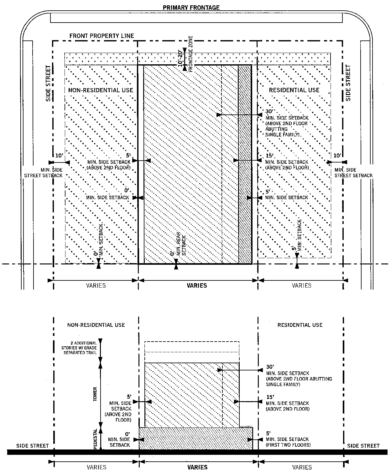
The interior side and rear setbacks shall be as depicted in the Building Placement Diagram below.
(7)
Where feasible, on-site parking shall be accessed from a service road or lowest-ranking street, based on the street development parameters set forth in this section.
(8)
Stories above the second story may be set back further than the requirements set forth in the Building Placement Standards Diagrams below.
(9)
Accessory buildings shall be permitted, provided that they do not encroach on the front and side street setbacks.
(10)
Setbacks for accessory buildings shall be the same as those for parking and allowable building area.
(11)
Building Placement Standards Diagram. All buildings shall be located in accordance with the following diagram:
(C)
Development parameters. All new development and redevelopment shall comply with the following development parameters:
(1)
Lots and Buildings.
(a)
When feasible, all buildings shall have their main pedestrian entrance opening to a street, open space, or trail.
(b)
Building features oriented toward a recreational trail, open space or toward a street shall be of human scale and have design variations at short intervals to create interest for trail and street users.
(c)
Building design shall use energy conservation measures, including but not limited to self-shading, natural lighting, natural ventilation, outdoor circulation, and reduced dependence on artificial lighting and air conditioning. Porches, balconies, breezeways, pergolas, deep eaves, eyebrows, and other elements promoting natural ventilation and shading are encouraged. Each building shall dedicate a specific location for recycling separation, storage, and access.
(d)
Glazing, Transparency and Storefront Requirements:
(1)
Portions of buildings facing or adjoining the building frontage zone shall be glazed as follows:
(i)
Office, hotel, and residential, minimum 30 percent;
(ii)
Retail, minimum 20 percent;
(iii)
Industrial, minimum 10 percent.
(iv)
Glazing of storefronts as provided below may count toward the overall building glazed area.
(v)
Glazing shall be clear or tinted, except where used for screening garages, where it may be translucent.
(2)
Where provided, storefronts shall:
(i)
Be located on the ground story and be directly accessible from the building frontage zone, sidewalk, or trail components; and
(ii)
Be a minimum of 60 percent clear-glazed for up to 80 percent of the height of the ground story; and
(iii)
Use only mesh-type security screens, if any, such that pedestrians can see through them, and place them only behind storefront displays; and
(e)
Fixtures, including but not limited to backflow preventers, pumps, underground ventilation exhausts, and electrical vaults, shall be located within or to the side or rear of buildings; such fixtures shall not be located within the building frontage zone.
(f)
Backflow preventers shall be shielded from view, in accordance with section 32-157(d).
(g)
Cantilevered building elements shall be permitted in the building frontage zone.
(h)
Awnings, balconies, roof eaves, open steps, pedestrian ramps, landscape planters and fountains may extend into or be located in the building frontage zone.
(2)
Trail Components.
(a)
Trail Components in the Development Areas shall connect to the trail components in the Recreational Trail Segments to form a clear, continuous, and improved trail with a minimum width of 15 feet along the length of the corridor. Within this continuous 15 foot minimum width of trail, there shall be no obstructions or Trail-Associated Amenities. This shall not be interpreted to prohibit the trail from including grade separated crossings.
(b)
Design of trail components should be consistent with the principles of Crime Prevention Through Environmental Design (CPTED).
(c)
When trail components are adjacent to properties that are zoned for or developed with single family or duplex residences, a minimum 15-foot landscaped buffer shall be provided. Said buffer shall be designed to mitigate sound and visual impacts from the trail component and shall be clear of any trail-associated amenities.
(d)
In Development Areas, the design of each development site shall integrate Trail Components. Where a development is approved with additional stories to accommodate a grade-separated Trail Component, the development shall incorporate an at-grade Trail Component, until the grade-separated Trail Component is constructed, operational, and open for use, and provides a continuous elevated pedestrian crossing of the adjacent roadway which connects to the trail on both sides of the roadway. Once the grade-separated Trail Component satisfies the above requirements, modifications to the site plan to remove the at-grade Trail Component may be approved administratively.
(e)
Grade-separated Trail Components shall be permitted, subject to the following:
(1)
Trail components may extend over the public right-of-way, subject to additional requirements and necessary permissions of the owner of the right-of-way.
(2)
The bottom of a grade-separated trail component shall be a minimum of 16 feet, 6 inches above the street.
(3)
Street and pedestrian lighting shall be provided along the underside of the grade-separated component, where appropriate.
(4)
Trail and connecting corridors shall have a minimum interior clear width of 15 feet. The exterior width of the elevated trail structure shall be no wider than 30 feet.
(5)
Trail Components shall be designed to facilitate access between street and trail levels. Elevators, ramps, stairs, or escalators linking the street and trail levels shall be conveniently located and identified with clear directional signs.
(6)
Trail Components may be enclosed, and where enclosed, at least 80 percent of the vertical enclosure of the trail shall be transparent or open. Windows, if provided, shall be of clear or lightly tinted glass that allow views into and out of the trail.
(f)
Louvers or other shade structures are permitted for shading and weather protection within the trail.
(g)
Wayfinding and directional signage providing information on destinations accessible throughout the trail shall be required within the trail structure, along pedestrian routes connecting to the trail in adjoining buildings, and at street-level building entrances. If the trail is open to the public, signage at building entrances leading to a trail shall state that the trails are open to the public and shall indicate the trail hours of operation. Wayfinding or directional signage shall be consistent with size, materials, and design standards contained in the Miami-Dade Parks, Recreation and Open Spaces Department's Sign Implementation Manual, as may be amended from time to time, which is maintained on file with the Department or successor department.
(h)
If the trail is open to the public, the trail shall be open to the general public 7 days a week from at least 7:00 A.M. to 10:00 P.M., unless otherwise approved by the Board of County Commissioners, including but not limited to extended hours on the weekends.
(i)
Trail Components shall be maintained in good order and free of deterioration, as defined in Section 19-15.3.
(3)
Streets.
(a)
New streets traversing a CD shall conform to the following street development parameters in Section 33-284.86:
(1)
When on-street parking is not provided, the development parameters for Street Type 5, Minor Street, Center Sub-district shall apply.
(2)
When on-street parking is provided, the development parameters for Street Types 3 or 4, Minor Street, Center Sub-district shall apply.
(b)
All new streets traversing an at-grade Trail Component shall safeguard the continuity of the trail by providing for a safe, seamless connection that is consistent in materials and treatment with that of the Trail Component and that emphasizes trail users over street traffic.
(c)
Overhead street cover. A maximum of 50 percent of a new private street may be covered above the first floor with structures connecting buildings, including trail components, roofs, upper story terraces, habitable space, garages, and automobile bridges between garages. Overhead street covers that meet the above requirements may be permitted on public rights-of-way to the extent allowed by state law.
(4)
Walls, Fences, and Hedges.
(a)
Walls, fences, and hedges may be placed within the building frontage zone, provided that the minimum sidewalk width is satisfied.
(b)
Walls, fences, and hedges shall not exceed 96 inches in height.
(c)
Chain link fences shall not be permitted facing or within the building frontage zone.
(5)
Open Space and Recreation Areas—Development Areas.
(a)
Designated open space shall be provided in the form of a minimum 15-foot wide continuous trail within the Development Areas.
(b)
Private Open Space shall also be provided as follows:
(1)
All multi-family residential and mixed-use developments shall reserve a minimum of 5 percent of the site for common open space.
(2)
Private open space may be provided in the form of colonnades, landscape areas, water features, pools, amenity areas, or, landscaped roof terraces.
(6)
Parking. Except as provided herein, parking shall be provided in accordance with Section 33-284.86(F).
(a)
Parking for Multi-family residential shall be provided as follows:
1 space/1 bedroom unit
2 spaces/2 bedroom unit
3 spaces/3 bedroom unit
Guest parking: 5 percent of required parking (for developments of 20 or more units).
(b)
Parking garages for parcels having a lot width of 100 feet or less.
(i)
Parking garages shall have architectural expression facing public streets, trail components and open spaces and shall be consistent and harmonious with that of habitable space. Architectural expression shall include balconies, glazing, awnings, or other similar architectural elements.
(ii)
Ramps should be internalized wherever possible.
(iii)
Exposed spandrels are prohibited.
(iv)
For the exposed top level of parking structures, a minimum of 60 percent of the area shall be covered with shade-producing structures, such as a vined pergola or retractable canvas shade structure; in connection with residential or office uses, shading may also be provided by a landscaped roof terrace or amenity area.
(v)
All garage lighting installations shall be designed to minimize direct spillage, sky glow, and hazardous interference with vehicular traffic on adjacent rights-of-way and all adjacent properties; this may be achieved through the use of down-turned building beams, garage screening, landscaping, or other similar architectural elements.
(7)
Landscape. Except as provided herein, landscape shall be provided in accordance with Section 33-284.86(E) pertaining to Urban Center Districts and Areas for properties designated MC and located in the Center Sub-districts. Required trees may be placed in open spaces within the Development Areas or within the Recreational Trail Segments of the corridor rather than being provided on the development site.
(8)
Signs. Signs shall comply with the requirements of Section 33-284.87 pertaining to Urban Center Districts and Areas.
(Ord. No. 17-91, § 1, 11-21-17)
Sec. 33-486. - Development Parameters and Design Standards for Recreational Trail Segments.
(A)
Trail Components. For all Recreational Trail Segments, the following shall apply:
(1)
The Trail Components in the Recreational Trails Segments shall connect to the trail components in the Development Areas to form a clear, continuous, and improved trail with a minimum width of 15 feet along the length of the corridor. Within this continuous 15 foot minimum width of trail, there shall be no obstructions or Trail-Associated Amenities. This shall not be interpreted to prohibit the trail from including grade separated crossings.
(2)
Design of trail components should be consistent with the principles of Crime Prevention Through Environmental Design (CPTED).
(3)
When trail components are adjacent to properties that are zoned for or developed with single family or duplex residences, a minimum 15-foot landscaped buffer shall be provided. Said buffer shall be designed to mitigate sound and visual impacts from the trail component and shall be clear of any trail-associated amenities.
(4)
Wayfinding and directional signage providing information on destinations accessible throughout the trail shall be required within the trail structure, along pedestrian routes connecting to the trail in adjoining buildings, and at street-level building entrances. If the trail is open to the public, signage at building entrances leading to a trail shall state that the trails are open to the public and shall indicate the trail hours of operation. Wayfinding or directional signage shall be consistent with size, materials, and design standards contained in the Miami-Dade Parks, Recreation and Open Spaces Department's Sign Implementation Manual, on file with the Department.
(5)
Class B (on-premises commercial or point of sales signs) on vending kiosks may be permitted, provided that such signs are limited to 1 sign per kiosk and that signs shall not exceed 12 square feet.
(6)
If the trail is open to the public, the trail shall be open to the general public 7 days a week from at least 7:00 A.M. to 10:00 P.M. unless otherwise approved by the Board of County Commissioners, including but not limited to extended hours on the weekends.
(7)
Trail Components shall be maintained in good order and free of deterioration, as defined in Section 19-15.3.
(Ord. No. 17-91, § 1, 11-21-17)
Sec. 33-487. - Review and Approval Procedures.
The review procedure for a CD is divided into two steps: (A) Initial development plan review (including public hearing approval for the rezoning to CD) and (B) Final plan review/Administrative Site Plan Review (ASPR). It is provided, however, that where a publicly-accessible Recreational Trail Segment is owned or operated by Miami-Dade County, development of that segment may instead be approved in accordance with the governmental facilities procedures set forth in section 33-303.
(A)
Initial Development Plan Review.
(1)
Review and public hearing process. The applicant shall attend at least one preapplication conference and may then initiate the initial development plan review upon the filing of a complete application.
(a)
The application for public hearing and the required exhibits shall be submitted to the Department in accordance with the requirements of section 33-304.
(b)
The review of the initial development plan of CD shall be by the Executive Council of the Developmental Impact Committee in accordance with the procedures in section 33-303.1.
(c)
One public hearing on the rezoning application shall be held by the Board of County Commissioners (Board), at which time the Board may consider the information presented by the applicant, the recommendations of the Executive Council of the Developmental Impact Committee, staff recommendations, testimony provided at the public hearing, and any information contained in the hearing file or submitted at the public hearing. Review and action by the Board of County Commissioners shall be in accordance with section 33-314.
(2)
Required written exhibits. The following written documents shall be submitted to the Developmental Impact Committee Executive Council for review prior to the first public hearing:
(a)
Quantitative data in a table format indicating the following:
(1)
Total acreage of Development Areas;
(2)
Total acreage of Recreational Trail Segments;
(3)
Identification of applicable land use areas (C-MC, C-MCI, or C-ID) within the Development Areas, along with:
(i)
Acreage of non-residential and residential uses;
(ii)
Range of proposed residential densities;
(iii)
Maximum CDMP density;
(iv)
Range of dwelling units;
(v)
Maximum height and floor area ratio;
(vi)
Maximum CDMP height and floor area ratio;
(vii)
Total amount of designated open space; and
(viii)
Total amount of private open space.
(b)
If an equivalency matrix is provided for the proposed uses in the Development Areas, it shall comply with the following:
(1)
"Equivalency Matrix" refers to a calculation of the total net external AM and/or PM peak hour vehicle trips generated using the latest edition of the ITE Trip Generation Manual rates and/or equations, or pursuant to an approved methodology, to determine the maximum total net external AM and/or PM peak hour vehicle trip generation associated with the overall development uses within the project.
(2)
The Equivalency Matrix shall include the total net external AM and/or PM hour vehicle trips calculated using the same ITE rates and/or equations for the simultaneous increases and decreases of the approved uses within a project, provided that the maximum total net external AM and/or PM peak hour vehicle trips are not increased.
(c)
If allowed by the CDMP, density transfer calculations.
(d)
A statement of compliance with the Development Parameters and Design Standards set forth in section 33-468.
(3)
Required graphic documents. Maps, site plans, and drawings depicting the proposed CD shall be submitted as part of the initial development plan review and shall contain the following minimum information:
(a)
A signed and sealed boundary survey.
(b)
Regulating Plans for the Development Areas.
(c)
A plan at a scale of 1"=300' that depicts the location of the following:
(1)
Depiction of the Development Areas and the Recreational Trail Segments.
(2)
General location of streets and points of ingress and egress.
(3)
Regarding the Development Areas:
(i)
General depiction of access points.
(ii)
Depiction of each of the land use designations with the following information:
1.
Location and acreage.
2.
Densities, floor area ratio and maximum height.
3.
Location of trail components and additional open space.
(iii)
General location of trail component/designated open spaces.
(4)
Regarding the Recreational Trail Segments:
(i)
Where adjacent to residential developments or districts, depiction of a minimum 15-foot landscaped buffer, which shall be designed to mitigate sound and visual impacts from the trail component and shall be clear of any Trail-Associated Amenities.
(ii)
Access roads.
(d)
Adequate information on land areas adjacent to the CD at a scale of 1"=300' to indicate the relationships between the proposed development and adjacent areas, including existing land uses, zoning districts, densities, vehicular and pedestrian circulation systems, and public facilities, as well as unique natural features of the landscape.
(e)
The proposed typical treatment of the perimeter of the CD, including materials and techniques to be used to provide transition to other developments, such as screens, landscape buffer, fences, walls and berms, when appropriate. This information shall be used in determining compatibility with adjacent uses.
(f)
Any additional information required by the Department to evaluate the character and impact of the application.
(B)
Final Development Plan Review for Development Areas. After a property has been rezoned to CD in accordance with subsection (A) above, development plans shall be subject to administrative review as provided herein.
(1)
Administrative Site Plan Review (ASPR).
(a)
Application Review. Upon submittal of an ASPR application, the Department shall review plans, including the exhibits listed below, for completeness and compliance with the provisions of this article and the design and site plan review criteria provided herein. Additionally, all applications shall be reviewed by the following County departments and other public entities for potential impacts on infrastructure and other services resulting from the application: Department of Transportation and Public Works, Department of Waste Management, Department of Regulatory and Economic Resources - Division of Environmental Resources Management, Water and Sewer Department, Miami-Dade Fire Rescue Department, and the Miami-Dade County School Board. In the event the application indicates impacts on services and infrastructure provided by any of the foregoing, the applicant shall meet with the affected department or entity to discuss potential mitigation of the impacts and shall submit evidence to the Department of such discussion.
(b)
Required Exhibits. The documents and site plan(s) to be reviewed and approved administratively during ASPR shall comply with the following:
(1)
A plan indicating existing zoning on site and adjacent areas.
(2)
Aerial photograph or map indicating site and development in the immediate area.
(3)
A plan depicting location of Development Areas and Recreational Trail Segments as well as the location of applicable land use areas within the Development Areas.
(4)
Site plan at no less than 1"=100' feet, which shall include the following information:
(i)
Location of land use areas;
(ii)
Location, shape, size and height of existing and proposed buildings, fences and walls;
(iii)
Building exterior finish materials;
(iv)
Lot lines, setbacks and frontage zones;
(v)
Location of trail components;
(vi)
Pedestrian and vehicular circulation systems;
(vii)
Location and size of additional open spaces;
(viii)
Location of on-street and off-street parking including type of permeable materials if uses on parking lots, loading facilities and waste collection areas, and for commercial establishments, multi-family residential establishments, and residential units, as defined in Chapter 15 of the Code, location of space for storage and collection of recyclable materials;
(ix)
Indication of signage;
(x)
Major changes in grade;
(xi)
Indication of any site or building design methods used to conserve energy;
(xii)
Location of backflow prevention devices and connections; and
(xiii)
Indication of placement and type(s) of lighting fixtures illuminating roadways, trail component, and parking areas.
(xiv)
For trail components in Development Areas, location, size, type, and materials of signs.
(5)
Landscape plans, including specifications of species of plant material, location, and size in accordance with this article and chapter 18A.
(6)
Street cross-sections, including adjacent buildings and open space.
(7)
Figures indicating the following:
(i)
Maximum density of development approved at public hearing.
(ii)
Density as proposed.
(iii)
Total dwelling units.
(iv)
Table of dwelling unit mix.
(v)
Total number of bedrooms.
(vi)
Table of buildings by heights, stories, unit types, and square footage.
(8)
Floor plans, elevations, and sections of all buildings, including total gross square feet of area for each floor and all dimensions relating to the requirements of this article. A pattern book may be submitted for detached and attached single-family units including, at a minimum, unit plans and elevations, elevation of unit groupings, and typical design details such as street lamps, benches, fencing, and paving details.
(9)
Optional signage plan in conformance with section 33-284.87.
(c)
In the case of multiple-phase development, each phase of the development, whether standing independently or in conjunction with existing developed or proposed future contiguous phases, shall meet all the requirements of this article.
(d)
Notwithstanding the review procedure contained herein, all requests for the subdivision of property within the Corridor District shall have previously received site plan approval in accordance with the requirements of this section.
(C)
Final Development Plan Review for Recreational Trail Segments. After a property has been rezoned to CD in accordance with subsection (A) above, final plans for Recreational Trail Segments shall require review and approval by the Board of County Commissioners after public hearing. In the alternative, review and approval of final plans for Recreational Trail Segments may be done simultaneously with the rezoning to CD. The documents and site plan(s) to be reviewed and approved shall comply with the following:
(a)
A plan indicating existing zoning on site and adjacent areas.
(b)
Aerial photograph or map indicating site and development in the immediate area.
(c)
Depiction of the Trail Component, as well as active and passive recreational areas and buffers.
(d)
Depiction of Trail-Associated Amenities, including specific types of Trail-Associated Amenities and locations thereof.
(e)
Compliance with Crime Prevention Thru Environmental Design (CPTED) to enhance trail safety and security.
(f)
Depiction of buffer from residentially-zoned or developed areas.
(g)
Location of access roads.
(h)
Location, size, type, and materials of signs.
(i)
Additional information, as required in the discretion of the Director.
(Ord. No. 17-91, § 1, 11-21-17; Ord. No. 18-134, § 16, 11-8-18)
Sec. 33-488. - Nonconforming structures and uses.
Nonconforming uses and structures shall be governed by the provisions of Section 33-35.
(Ord. No. 17-91, § 1, 11-21-17)
Sec. 33-489. - Conflicts with other regulations.
When conflicts with other zoning, subdivision, or landscape regulations occur, this article shall take precedence, with the exception of the County Sign Code, which shall control in the event of a conflict. Where conflicts occur with Miami-Dade Department of Public Works and Waste Management Manual of Public Works, as may be amended from time to time and maintained on file with the Department or successor department, this article shall take precedence, unless otherwise approved by the Director and the Public Works Director.
(Ord. No. 17-91, § 1, 11-21-17)