
Miami Dade County Unincorporated
City Zoning Code
City Zoning Code
ARTICLE XXXIIIO
OJUS URBAN AREA DISTRICT
Sec. 33-284.99.14.- Purpose, intent and applicability.
A.
The regulations contained in this chapter and Chapter 18A, Landscape Code, Code of Miami-Dade County, Florida, shall apply to this article, except as otherwise added to or modified herein.
B.
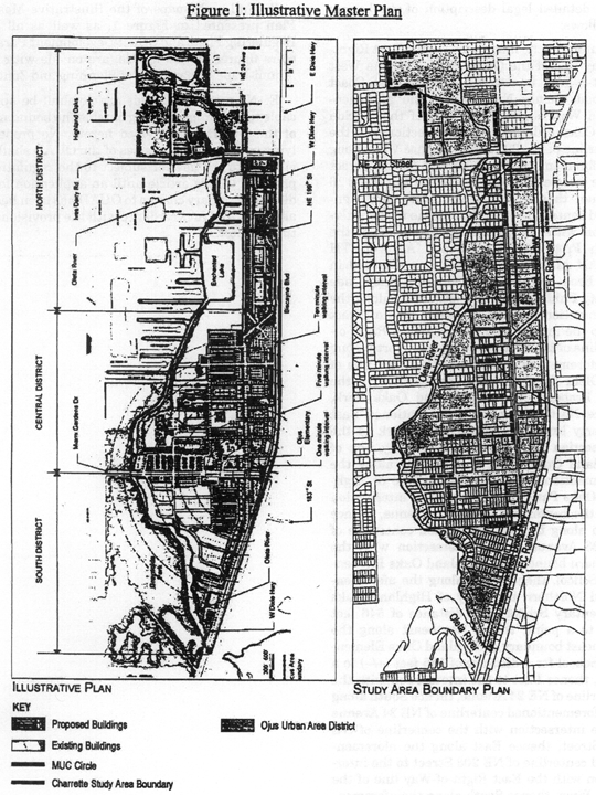
The Illustrative Master Plan (Figure 1), illustrates the citizens' vision and may be used to interpret this article. Where the Illustrative Master Plan conflicts with the text of this article, the text shall govern.
C.
The regulations contained in this chapter address portions of the Ojus/Aventura Metropolitan Urban Center and its surrounding area, hereafter the Ojus Urban Area District (OUAD), which shall be governed as a Community Urban Center District. Specifically, the regulations address an area with the boundaries shown in Figure 1, which illustrates the OUAD Boundary Plan, and generally described as follows: from the crossing of the Oleta River with the west side of the Florida East Cost (FEC) railroad easement, then north along the west side of the FEC railroad easement to the south side of NE 203 Street, then west along the south side of NE 203 Street to the west side of NE 26 Avenue, then north along the west side of NE 26 Avenue to the south side of theoretical NE 206 Street then west along the south side of theoretical NE 206 Street to the eastern boundary of the Highland Oaks Park, then north and west along the boundary of Highland Oaks Park to the east side of NE 23 Avenue, then south on the east side of NE 23 Avenue to the north side of NE 207 Street, then east along the north side of NE 207 Street to the east side of NE 24 Avenue, then south along the east side of NE 24 Avenue to the south side on NE 203 Street, then east along the south side of NE 203 Street to the Oleta River, then south along the Oleta River to the point of beginning.
D.
Full scale maps and a legal description of the boundaries of the Illustrative Master Plan presented in Figure 1, as well as all the Regulating Plans and Street Development Parameters figures, are on file with the Department.
E.
No provision in this article shall be applicable to any property lying outside the boundaries of the OUAD as described herein. No property lying within the boundaries of the OUAD shall be entitled to the uses or subject to the regulations provided in this article until an application for a district boundary change to OUAD has been heard and approved in accordance with the provisions of this chapter.
(Ord. No. 06-86, § 1, 6-6-06; Ord. No. 16-91, § 13, 9-7-16)
Sec. 33-284.99.15. - Ojus Urban Area District (OUAD) Requirements.
Except as provided herein, all developments within the OUAD shall comply with the requirements provided in Article XXXIII(K), Standard Urban Center District Regulations, of this Code.
(Ord. No. 06-86, § 2, 6-6-06)
Sec. 33-284.99.16. - Reserved.
Editor's note— Section 1 of Ord. No. 07-94, adopted July 10, 2007, deleted § 33-284.99.16, which pertained to definitions and derived from Ord. No. 06-86, adopted June 6, 2006.
Sec. 33-284.99.17. - Uses.
Except as provided herein, all permitted, conditionally permitted, and temporary uses within the OUAD shall comply with Section 33-284.83 of this Code.
1.
As provided in the Land Use Regulating Plan, no duplexes shall be permitted in areas designated:
a.
Residential (R) with a maximum permitted density of 6 dwelling units per net acre; and
b.
Residential Modified (RM) with maximum permitted densities greater or equal to 36 units per net acre.
2.
No recreation building, playground, or park owned and operated by a municipality, county, state, or the federal government shall be permitted in areas designated R on the Land Use Regulating Plan.
3.
No civic uses shall be permitted in areas designated R on the Land Use Regulating Plan, except for educational facilities on properties not to exceed 5 acres.
4.
Institutional uses. The following additional uses shall be permitted in the Institutional (I) area in accordance with the Land Use Regulating Plan and the Street Types Development Parameters.
a.
Civic uses in accordance with the Street Types Development Parameters.
b.
On lots located west of NE 25th Avenue, all uses permitted in the Residential (R), with the density shown on the Density Plan.
c.
On lots located east of NE 25th Avenue, all uses permitted in the Residential Modified (RM), with the density shown on the Density Plan.
5.
Residential Modified Live/Work (RML). The following uses shall be permitted in the Residential Modified Live/Work (RML), in accordance with the Land Use Regulating Plan and the Street Types Development Parameters:
a.
All uses permitted in the Residential Modified (RM); and
b.
Live/work units.
6.
In the Mixed-Use Corridor (MC) in the Core or Center Sub-districts, located along West Dixie Highway (Northeast SMART Corridor), between NE 195th Street and NE 202nd Street, transit or rail stations and ancillary uses shall be permitted.
(Ord. No. 06-86, § 4, 6-6-06; Ord. No. 07-94, § 2, 7-10-07; Ord. No. 14-14, § 1, 2-4-14; Ord. No. 15-17, § 1, 3-17-15; Ord. No. 19-120, § 2, 12-3-19)
Sec. 33-284.99.18. - Reserved.
Editor's note— Ord. No. 16-91, § 14, adopted Sept. 7, 2016, repealed § 33-284.99.18, which pertained to the regulating plans and derived from Ord. No. 06-86, § 5, adopted June 6, 2006; Ord. No. 07-94, § 3, adopted July 10, 2007; Ord. No. 14-14, § 2, adopted Feb. 4, 2014; Ord. No. 15-17, § 2, adopted March 17, 2015; Ord. No. 15-145, § 1, adopted Dec. 1, 2015; and Ord. No. 16-27, § 1, adopted March 8, 2016.
Sec. 33-284.99.19. - Building Placement and Street Type Development Parameters
A.
All new development and redevelopment within the OUAD shall comply with the Building Placement Standards as provided in Article XXXIII(K) of this Code.
B.
All new development and redevelopment within the OUAD shall comply with the Streets, Service Roads and Utilities standards in Article XXXIII(K) of this Code or as provided herein:
C.
The following setbacks shall be required where a Building Placement Standard in Article XXXIII(K) of this Code refers to a Frontage Table:
D.
Street Types Development Parameters.
Main Street
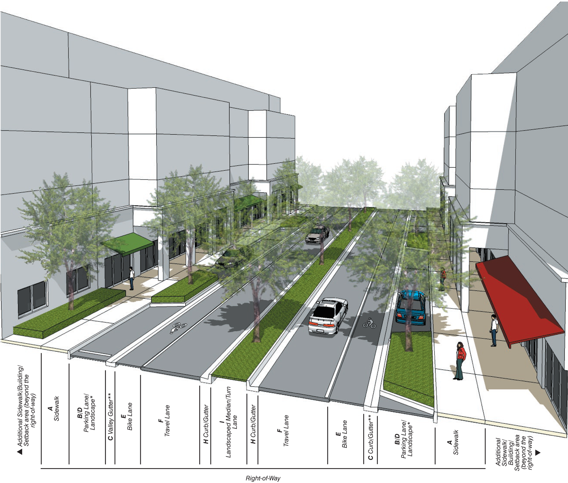
* Refer to column B in Street Types Table for required landscape elements.
** Curb and gutter between the sidewalk and parking/travel lanes may be utilized in place of the valley gutter illustrated.
Boulevard
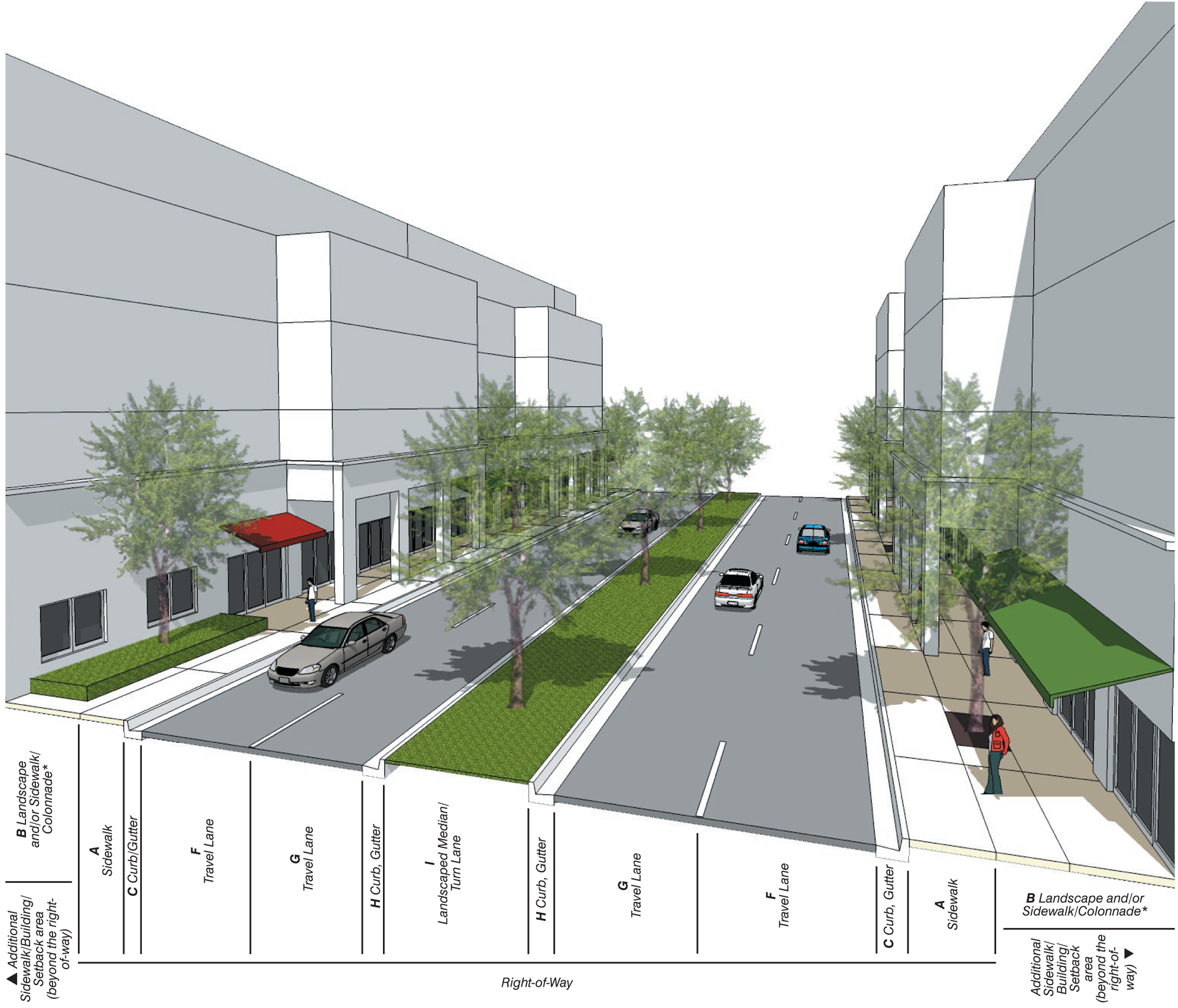
* Refer to column B in Street Types Table for required landscape elements.
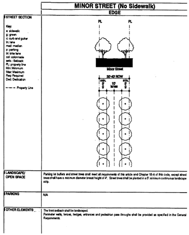
Minor Street, Sidewalks not required
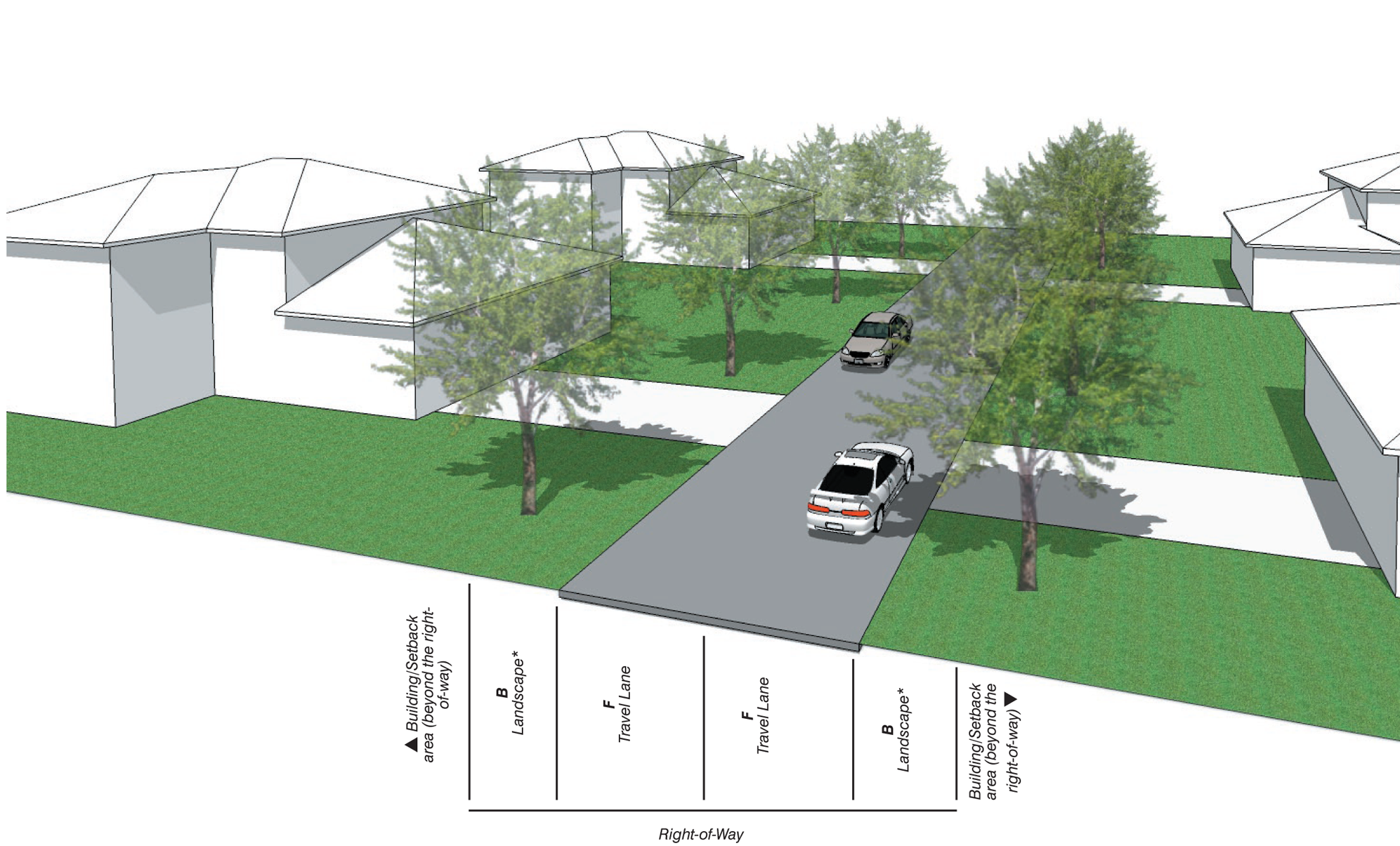
* Refer to column B in Street Types Table for required landscape elements.
Footnotes:
a.
Landscape area is exclusive of the minimum sidewalk width.
b.
Street trees shall have a minimum caliper of six (6) inches at time of planting.
c.
Permanent irrigation is required.
d.
Tree grates shall have a minimum area of twenty-four (24) square feet; tree planters shall have a minimum area of thirty-two (32) square feet; continuous landscape strips shall have a minimum width of six (6) feet in the Core and Center Sub-districts, eight (8) feet in the Edge Sub-district.
e.
In all Sub-districts, curbs and gutters shall be provided at all intersections and roadway edges of arterials, boulevards and Main Street; in Core and Center Sub-districts, curbs and gutters shall be provided at all intersections and roadway edges of minor streets.
g.
Bike lanes shall be four (4) feet in width when adjacent to curb or swale; five (5) feet in width when adjacent to a parking lane.
h.
The minimum required width of one-lane/one-way travel lanes shall be determined by the Department of Public Works and Waste Management and Fire Rescue Department on a case-by-case basis during the Administrative Site Plan Review process (ASPR).
(Ord. No. 06-86, § 6, 6-6-06; Ord. No. 07-94, § 4, 7-10-07; Ord. No. 14-14, § 3, 2-4-14)
Sec. 33-284.99.20. - General Requirements.
In addition to the requirements in Section 33-284.86 of this Code, and to retain the character of the development within the OUAD, all new development and redevelopment shall comply with the following:
A.
Heights of Buildings.
1.
Except where exempted as depicted on the Building Heights Plan, where a proposed development abuts an area designated Residential (R) on the Land Use Regulating Plan, the height of the proposed development along the abutting property line, for a minimum depth of 50 feet, shall be no greater than the maximum height allowed in the abutting area designated R. Examples of the required height transition are shown herein.
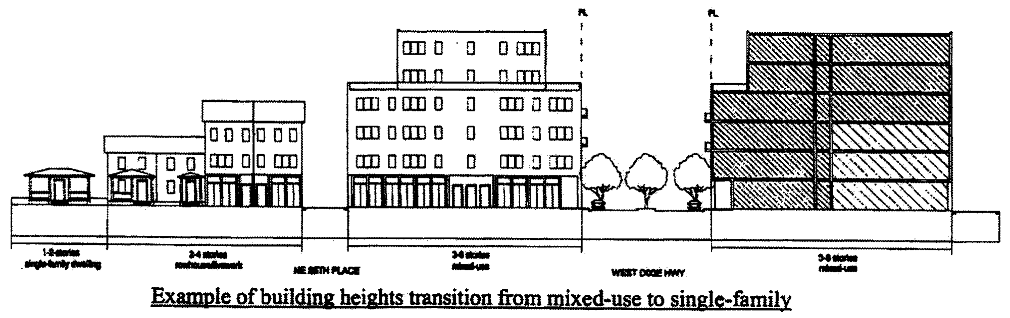
Example of Building Heights Transition from Mixed-Use to Single-Family
Each story shall have a maximum height of 16 feet, as measured from floor to floor. Any height above 16 feet shall count as an additional story, except that a single story may have a maximum height of 30 feet, provided that no mezzanine area intended for commercial use exceeds 10 percent and no mezzanine area intended for residential use exceeds 80 percent of the floor area of that story.
B.
Architectural Guidelines.
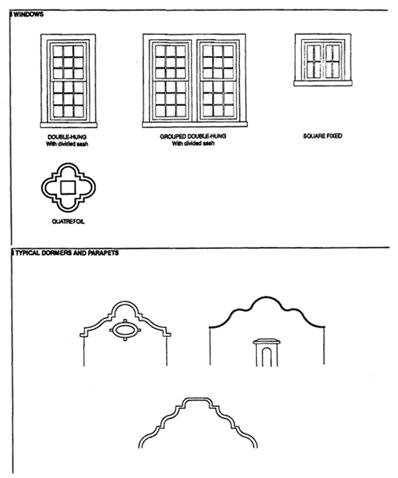
To retain the character of the development in the OUAD area and to recognize its architectural history, all new single-family development within the OUAD area shall conform with either the Florida Vernacular or the Mission style as shown in the figures below. Specifically and at a minimum, all new single-family homes within the area shall include each of the required elements, respective to the chosen architectural style, described herein:
C.
Walls, fences, and hedges.
All walls, fences, andhedges shall be provided in compliance with Section 33-284.86 of this Code, except that walls, fences, and hedges associated with residential, single-family homes that were legally established prior to March 8, 2007, shall be permitted to a maximum height of seventy-two (72) inches, regardless of location.
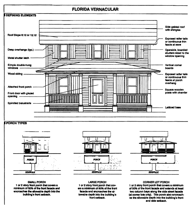
Florida Vernacular
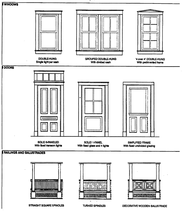
Florida Vernacular (Windows, Doors, Railings/Balustrades)
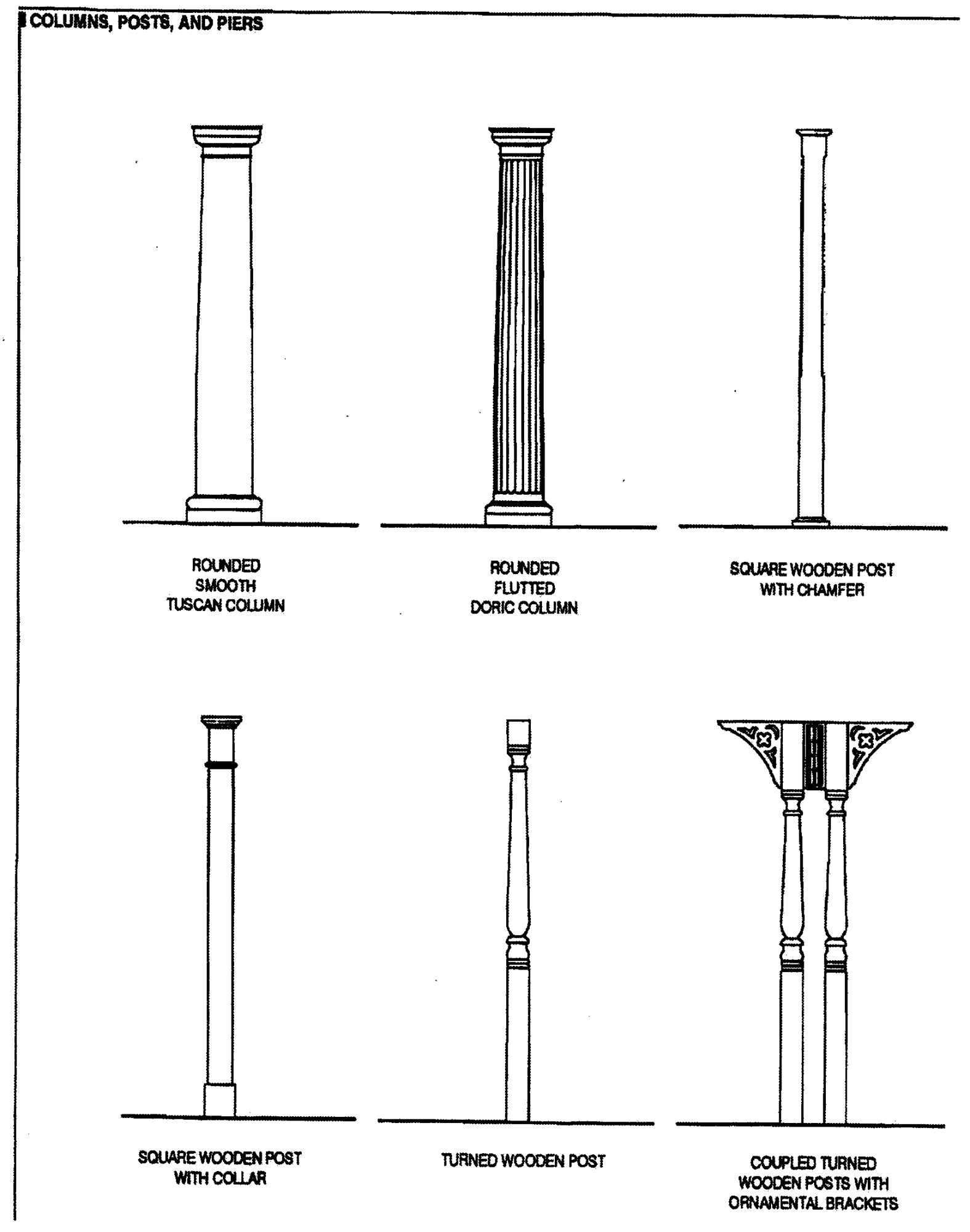
Florida Vernacular (Columns, Posts, Piers)
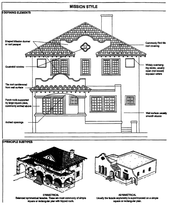
Mission Style
(Ord. No. 06-86, § 7, 6-6-06; Ord. No. 16-49, § 1, 5-17-16)
Sec. 33-284.99.21. - Conflicts with other Chapters and Regulations.
This article shall govern in the event of conflicts with other zoning, subdivision, or landscape regulations of this Code, or with the Miami-Dade Department of Public Works Manual of Public Works.
(Ord. No. 06-86, § 8, 6-6-06)
Sec. 33-284.99.22. - Non-conforming Structures, Uses, and Occupancies.
Non-conforming Structures, Uses, and Occupancies shall be governed by the provisions of Section 33-284.89.2 of this chapter.
(Ord. No. 06-86, § 9, 6-6-06; Ord. No. 14-14, § 4, 2-4-14)