
Salem City Zoning Code
CHAPTER 112
MEASUREMENTS
Sec. 112.001.- Purpose.
The purpose of this chapter is to establish methods for measurements in the UDC.
(Prior Code, § 112.001; Ord. No. 31-13)
Sec. 112.005. - Cul-de-sac length.
Cul-de-sac length shall be measured from the nearest right-of-way line of the nearest intersecting street to the throat or point of beginning of the turnaround area.
(Prior Code, § 112.005; Ord. No. 31-13)
Sec. 112.010. - Distance.
Unless otherwise provided under the UDC, all distances shall be calculated by measuring the horizontal distance between two points (see Figure 112-1).
FIGURE 112-1. DISTANCE
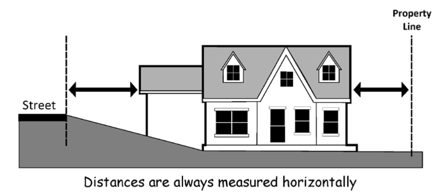
(Prior Code, § 112.010; Ord. No. 31-13)
Sec. 112.015. - Dwelling unit density.
(a)
Generally. The number of dwelling units permitted on property shall be calculated by dividing the lot area in square feet by 43,560 and multiplying that figure by the minimum or maximum density allowed. Any computation that yields a fraction of less than 0.5 shall be rounded down to the nearest whole number and any computation that yields a fraction of 0.5 or greater shall be rounded up to the next nearest whole number.
(b)
Single-room occupancy. Dwelling unit density for single room occupancy shall be calculated as required for other residential uses pursuant to subsection (a) of this section, except that each attached, lockable, room being rented independently shall be counted as one dwelling unit. Where single-room occupancy is located on the same property as other residential uses, the total number of rooms and total number of dwelling units shall be counted cumulatively toward the minimum and maximum density allowed.
(Prior Code, § 112.015; Ord. No. 31-13; Ord. No. 1-20, § 2(Exh. B), 2-24-2020; Ord. No. 7-23, § 1(Exh. A), 11-27-2023)
Sec. 112.020. - Floor area ratio.
Floor area ratio shall be calculated by dividing the total floor area of all buildings on a lot by the lot area (see Figure 112-2).
FIGURE 112-2. FLOOR AREA RATIO
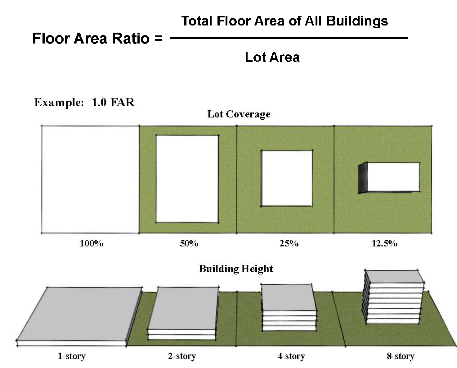
(Prior Code, § 112.020; Ord. No. 31-13)
Sec. 112.025. - Fractions.
Unless otherwise provided under the UDC, where a regulation is expressed in terms of a minimum numerical requirement, any computation that yields a fraction of less than 0.5 shall be rounded down to the nearest whole number and any computation that yields a fraction of 0.5 or greater shall be rounded up to the next nearest whole number.
(Prior Code, § 112.025; Ord. No. 31-13)
Sec. 112.030. - Ground floor windows.
Unless otherwise provided under the UDC, where a minimum percentage of windows are required on the ground floor of a building, the percentage of windows shall be calculated by:
(a)
Dividing the total area of windows on the ground floor of the building by the area of the ground floor of the building; or
(b)
Dividing the total width of windows along the ground floor of the building by the length of the ground floor of the building. This method of calculation may be used only if the windows have a vertical dimension that equals six feet or more in height.
(Prior Code, § 112.030; Ord. No. 31-13)
Sec. 112.035. - Height.
(a)
Calculation. Height is calculated by measuring the vertical distance between two points, a base point and a top point. Unless otherwise provided under the UDC, the base point is the lowest point on the grade abutting that which is being measured, and the top point is the highest point on that which is being measured.
(b)
Structures exceeding maximum height. When the UDC provides that a building or structure may exceed a maximum height by a specified amount, the amount allowed greater than the maximum height shall be measured from the top point of the building or structure.
(c)
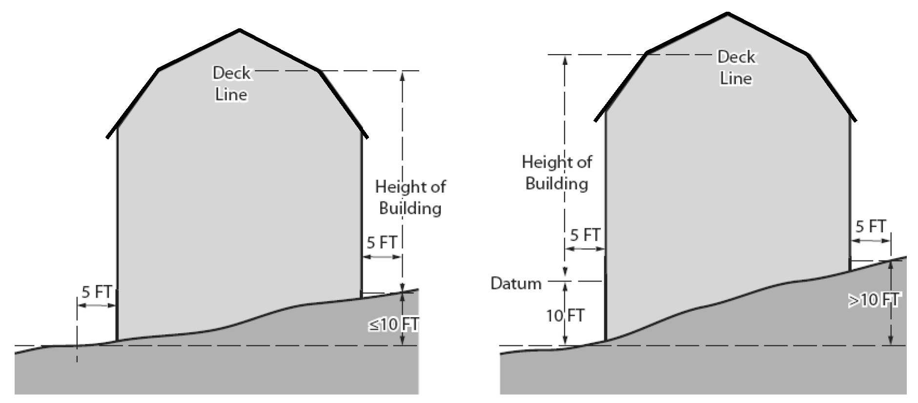
Height of buildings and structures. Unless otherwise provided under the UDC, building and structure height shall be measured as set forth under this subsection.
(1)
Base point. The base point for purposes of determining building and structure height shall be:
(A)
The elevation of the highest adjoining sidewalk or ground surface within a five-foot horizontal distance of the exterior wall of the building or structure, when such sidewalk or ground surface is not more than ten feet above the lowest grade within the five-foot horizontal distance; or
(B)
An elevation that is ten feet higher than the lowest grade within a five-foot horizontal distance of the exterior wall of the building or structure, when the elevation of the highest adjoining sidewalk or ground surface within a five-foot horizontal distance of the exterior wall of the building or structure is ten feet or more above lowest grade within such five-foot horizontal distance.
(2)
Top point. The top point for purposes of measuring building and structure height shall be:
(A)
The highest point of the coping of a flat roof (see Figure 112-3A).
(B)
The average height of a shed roof.
(C)
The average height of the highest gable of a pitched or hipped roof (see Figure 112-3B).
(D)
The deck line of a curb, gambrel, or mansard roof (see Figure 112-3C).
(E)
For a stepped or terraced building, the highest point of any step or terrace of the building.
FIGURE 112-3A. BUILDING HEIGHT - FLAT ROOF
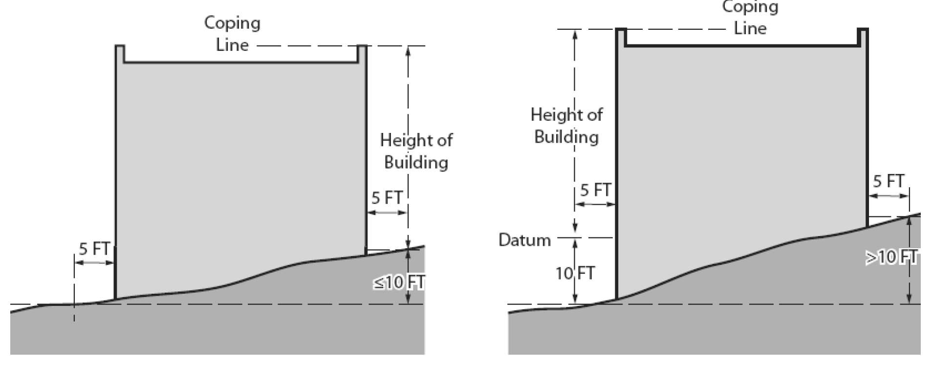
FIGURE 112-3B. BUILDING HEIGHT - PITCHED OR HIPPED ROOF
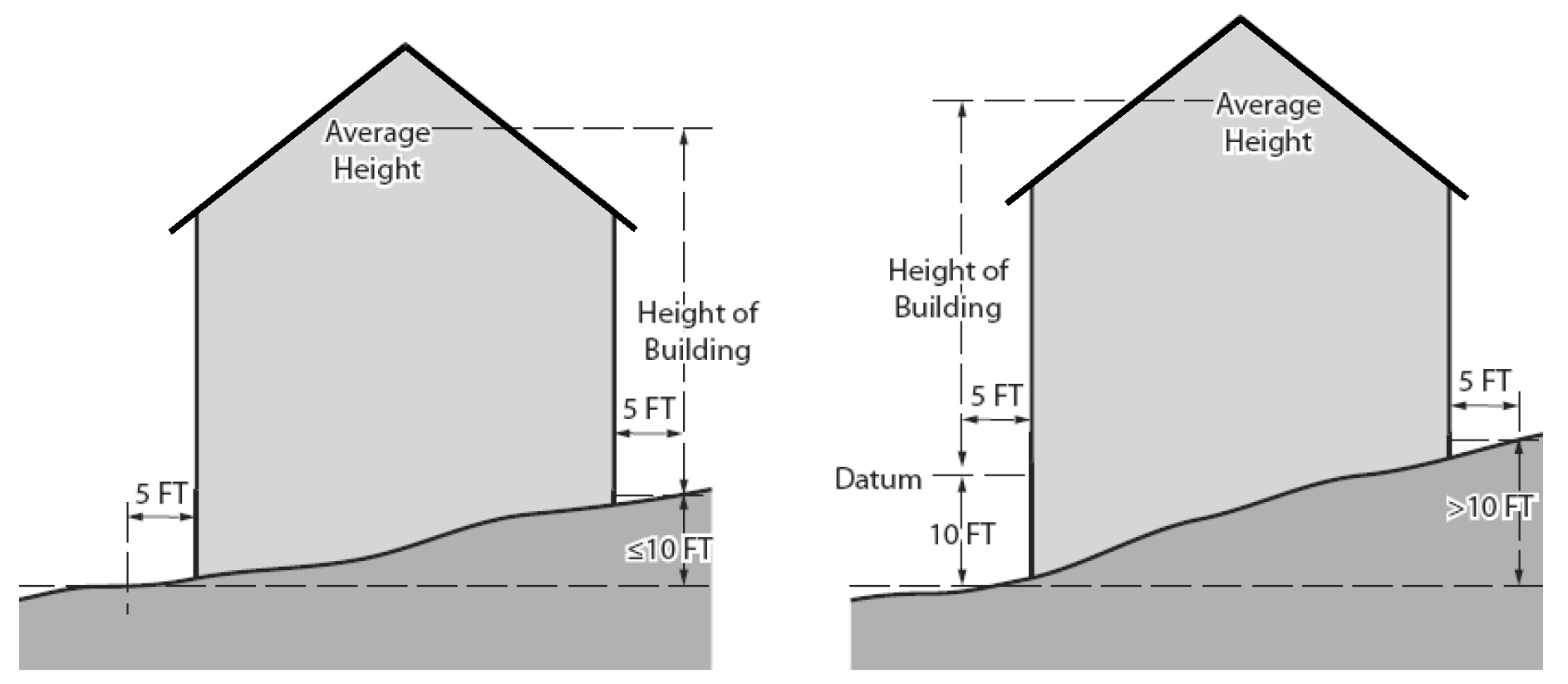
FIGURE 112-3C. BUILDING HEIGHT - CURB, GAMBREL, AND MANSARD ROOF
(d)
Height of fences.
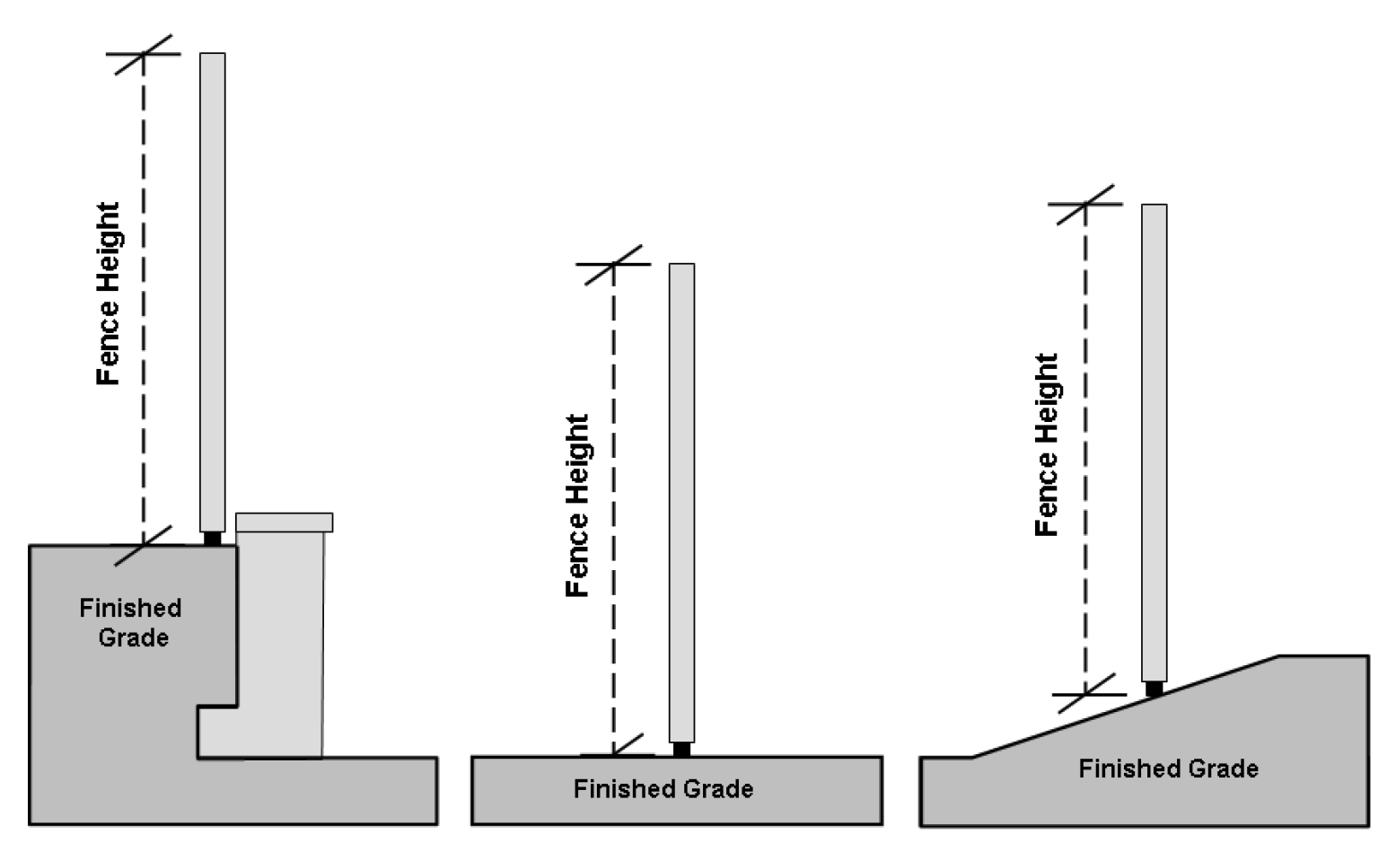
(1)
Except as provided in subsection (d)(2) of this section, fence height shall be measured from the finished grade upon which the fence is constructed to the top of the fence (see Figure 112-4).
(2)
Fence height adjacent to street. When located within three feet of a property line abutting a street, fence height shall be measured from the sidewalk to the top of the fence. If no sidewalk exists, the height of the fence shall be measured from the curb to the top of the fence. If no curb exists, the height of the fence shall be measured from the finished shoulder grade of the right-of-way to the top of the fence.
FIGURE 112-4. MEASUREMENT OF FENCE HEIGHT
(e)
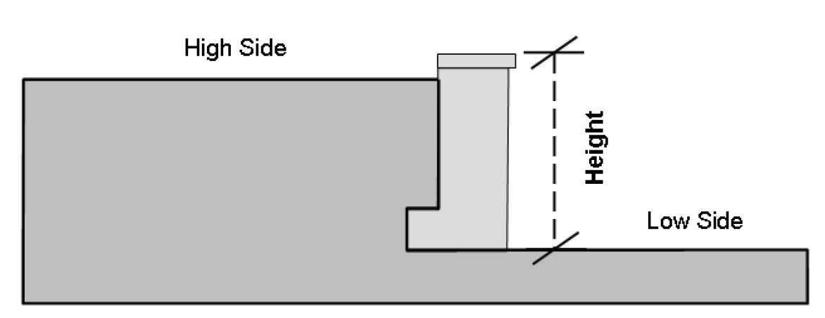
Height of retaining walls. Retaining walls shall be measured from the finished grade on the lower side of the retaining wall to the top of the retaining wall (see Figure 112-5).
FIGURE 112-5. MEASUREMENT OF RETAINING WALL HEIGHT
(f)
Height of porches, decks, and patios. Porch, deck, and patio height shall be measured from the finished grade directly beneath the outside edge of the porch, deck, or patio to the top of the floor of the porch, deck, or patio.
(g)
Measurement of height within Airport Overlay Zone. Notwithstanding any other provision in this section, height within the Airport Overlay Zone shall be measured from mean sea level elevation to the highest point of the building, structure, object, or vegetative growth.
(Prior Code, § 112.035; Ord. No. 31-13; Ord. No. 13-21, § 1(Exh. A), 2-14-2022)
Sec. 112.040. - Lot coverage.
Lot coverage is the percentage of a lot covered by structures. Unless otherwise provided under the UDC, lot coverage shall be calculated by dividing the total area of the lot covered by structures by the total area of the lot; provided, however, the following structures, or portions thereof, shall not be included in calculating lot coverage:
(a)
Any unroofed portion of a structure.
(b)
Any structure that is less than five feet in height and that has less than 20 square feet of gross floor area, including, but not limited to, pet shelters and play houses.
(Prior Code, § 112.040; Ord. No. 31-13)
Sec. 112.045. - Lot dimensions.
(a)
Lot area. Lot area is the total horizontal area in square feet or acres contained within a lot. Lot area shall be measured exclusive of any flag lot accessway.
(b)
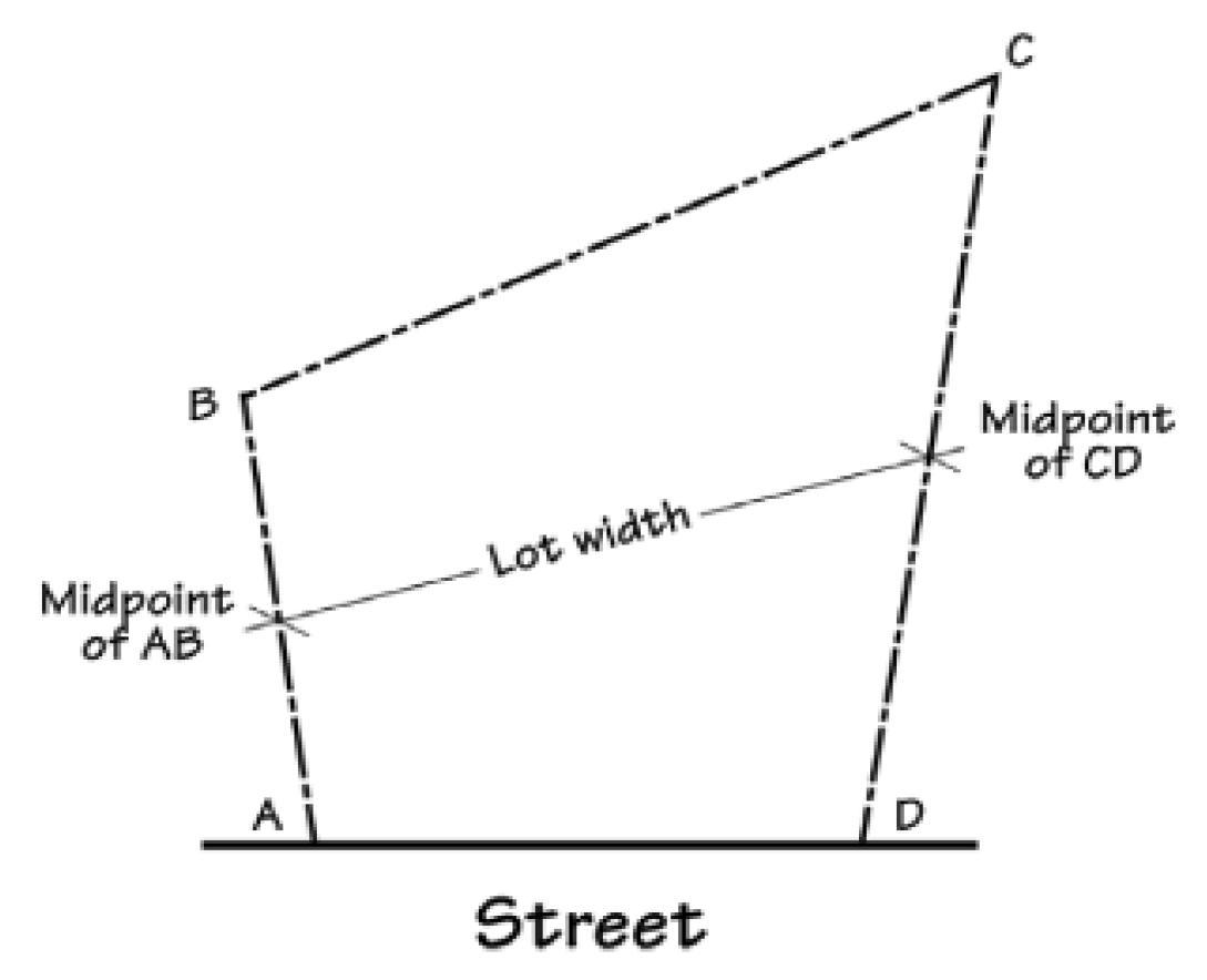
Lot width. Lot width is the horizontal distance between the side lot lines. Lot width shall be measured at a point halfway between the front and rear lot lines (see Figure 112-6). Lot width shall be measured exclusive of any flag lot accessway.
FIGURE 112-6. MEASUREMENT OF LOT WIDTH
(c)
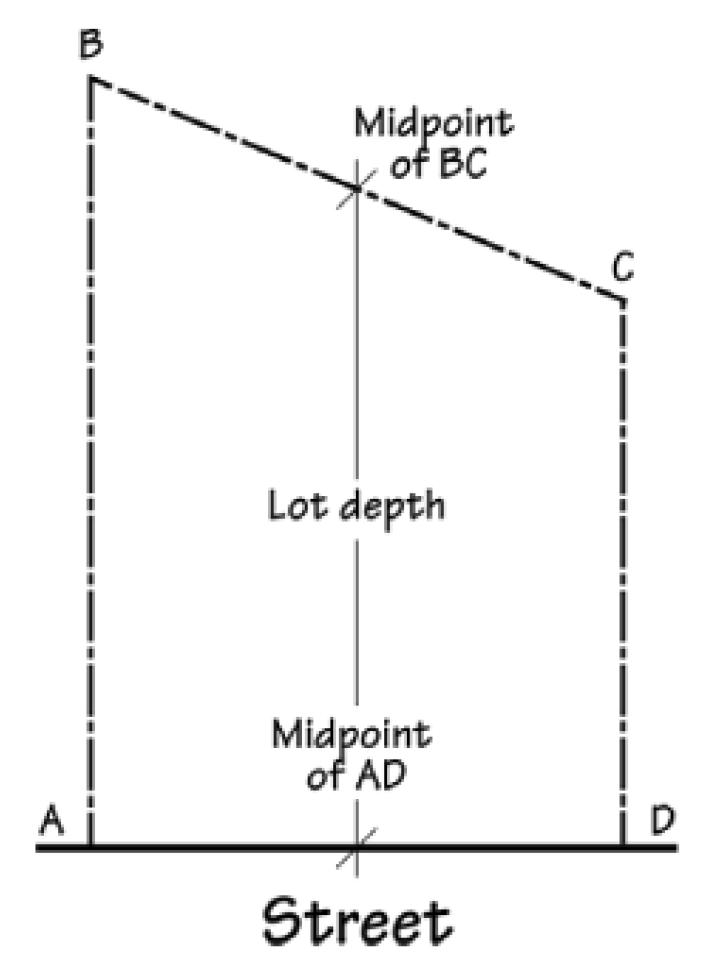
Lot depth. Lot depth is the horizontal distance between the front and rear lot lines. Lot depth shall be measured at a point halfway between the side lot lines (see Figure 112-7). Lot depth shall be measured exclusive of any flag lot accessway.
FIGURE 112-7. MEASUREMENT OF LOT DEPTH
(d)
Street frontage. Street frontage shall be measured exclusive of any flag lot accessway.
(Prior Code, § 112.045; Ord. No. 31-13)
Sec. 112.050. - Setbacks.
(a)
Generally. Setbacks are measured along a line that is perpendicular to the property line and extended from the property line inward toward the center of the lot. If the property line is curved, the setback shall be measured along a line that is a radius to the curve and extended from the lot line inward to the center of the lot.
(b)
Garage or carport vehicle entrance setback abutting street or flag lot accessway. The setback for the vehicle entrance of a garage or carport facing a street or flag lot accessway shall be measured from one of the following lines, whichever is closest to the proposed vehicle entrance of the garage or carport:
(1)
The street right-of-way line, most interior access easement line, or property line abutting a flag lot accessway;
(2)
The outside curbline; or
(3)
The edge of the sidewalk furthest from the street.
(c)
Setbacks abutting flag lot accessway. Setbacks abutting a flag lot accessway shall be measured from one of the following lines, whichever is most interior to the lot or parcel:
(1)
The property line; or
(2)
The most interior access easement line, if an access easement exists.
(d)
Setback abutting waterway. Unless otherwise provided under the UDC, where a setback is required abutting a waterway, the setback shall be measured horizontally from the top of bank on the side of the waterway that is adjacent to the subject property.
(Prior Code, § 112.050; Ord. No. 31-13; Ord. No. 13-21, § 1(Exh. A), 2-14-2022)
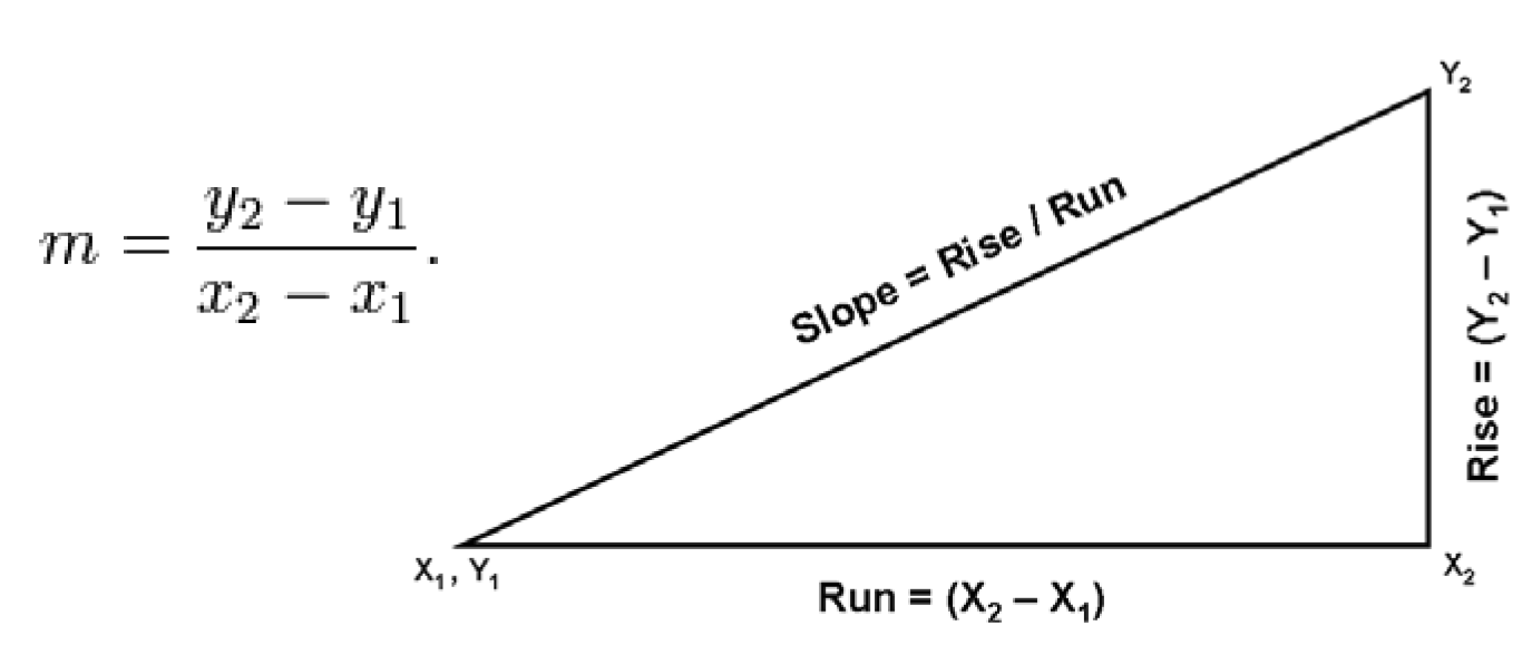
Sec. 112.055. - Slope.
Slope is the ratio of the "rise" divided by the "run" between two points.
(a)
Calculating slope. Slope is calculated as the ratio of the altitude change ("rise") to the horizontal distance ("run") between two points on a line. Given two points (x1,y1) and (x2,y2) on a line, the slope (m) of the line is calculated as shown in Figure 112-8.
FIGURE 112-8. SLOPE
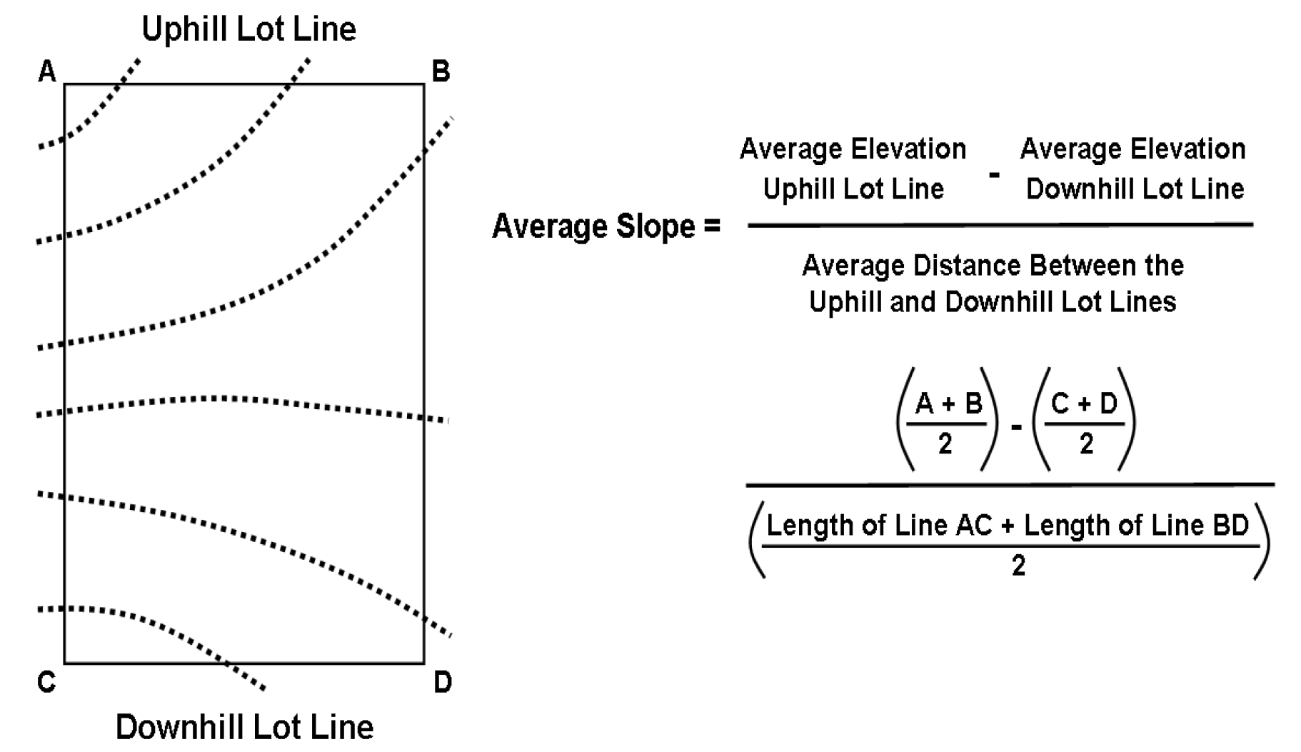
(b)
Calculating average cross slope. Average cross slope is calculated by dividing the average change in elevation between the uphill lot line and the downhill lot line by the average distance between the uphill lot line and the downhill lot line (see Figure 112-9).
FIGURE 112-9. AVERAGE CROSS SLOPE
(Prior Code, § 112.055; Ord. No. 31-13)
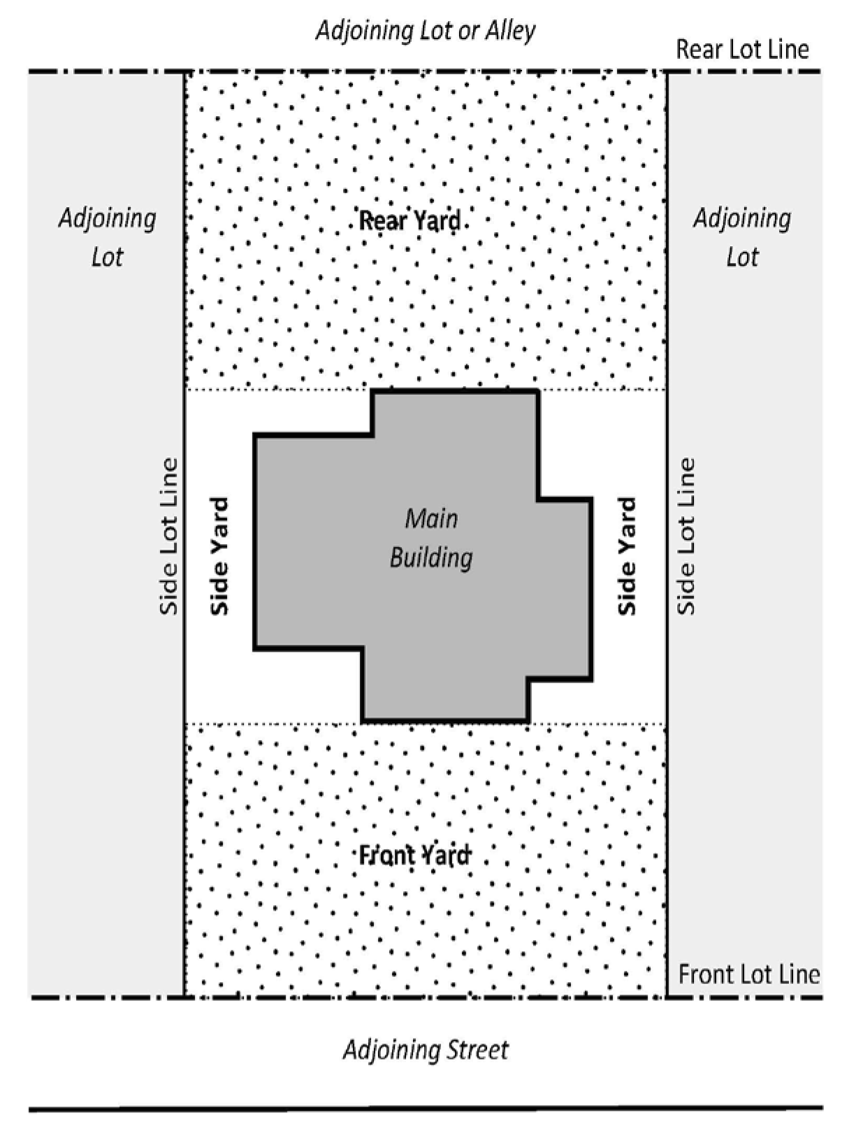
Sec. 112.060. - Yards.
(a)
Front yard. The front yard is the area located between the main building and the front lot line, and extending across the full width of the lot (see Figure 112-10). Unless otherwise provided under the UDC, front yard depth is the horizontal distance between the front lot line and the point on the foundation of the main building that is nearest to the front lot line.
(b)
Side yard. A side yard is the area located between the main building and a side lot line, and extending between the front yard and rear yard (see Figure 112-10).
(c)
Rear yard. The rear yard is the area located between the main building and the rear lot line, and extending across the full width of the lot (see Figure 112-10). Unless otherwise provided under the UDC, rear yard depth is the horizontal distance between the rear lot line and the point on the foundation of the main building that is nearest to the rear lot line.
FIGURE 112-10. YARDS
(Prior Code, § 112.060; Ord. No. 31-13)