
Salem City Zoning Code
CHAPTER 531
SWMU—SOUTH WATERFRONT MIXED-USE
Sec. 531.001.- Purpose.
The purpose of the South Waterfront Mixed-Use (SWMU) Zone is to implement the river-oriented mixed-use designation of the Salem Area Comprehensive Plan through the identification of allowed uses and the establishment of development standards to further economic development and support the creation of a vibrant downtown. The SWMU provides for a mixture of uses developed in a manner that promotes an active and inviting pedestrian environment, and that takes advantage of close proximity to Pringle Creek, Riverfront Park, the Willamette River, and the downtown.
(Prior Code, § 531.001; Ord. No. 31-13)
Sec. 531.005. - Definitions.
The following words, terms and phrases, when used in this chapter, shall have the meanings ascribed to them in this section, except where the context clearly indicates a different meaning:
Development site means a single building, all or a portion of a single lot, or all or a portion of multiple lots within a single ownership or control (i.e., lands included within the land use application), as determined by the applicant.
Ground floor means the first full building floor which is not more than two feet above grade. For buildings facing Pringle Creek, ground floor means the floor most closely aligned with street level.
Ground floor area means the floor area of a building or structure devoted to a particular use, measured within the exterior walls that are at the grade plane of the building or structure.
Total floor area means the floor area of a building or structure devoted to a particular use, measured within the exterior walls of all stories of a building or structure.
(Prior Code, § 531.005; Ord. No. 31-13)
Sec. 531.010. - Uses.
(a)
General. The permitted (P), special (S), conditional (C), and prohibited (N) uses in the SWMU zone are set forth in Table 531-1.
(b)
Additional prohibited uses. Notwithstanding Table 531-1, any permitted, special, or conditional use within the SWMU zone less than 10,000 square feet in total floor shall be a prohibited use within the SWMU zone if developed with a drive-through.
(c)
Limitations on uses. Where a use is allowed subject to the provisions of this subsection, the use shall conform to the following additional limitations:
(1)
Establishments under the following uses shall be limited to no more than 10,000 square feet of total floor area per establishment:
(A)
Laboratory research and testing.
(B)
Building and grounds services and construction contracting.
(C)
Cleaning plants.
(D)
General manufacturing.
(E)
Printing.
(2)
The total floor area of all establishments falling under motor vehicle and manufactured dwelling and trailer sales shall be limited to a maximum of 20,000 square feet.
(3)
Buildings for establishments under the following uses shall be limited to no more than 40,000 square feet of ground floor area:
(A)
Retail sales, with the exception of grocery stores. Grocery stores shall be limited to buildings with no more than 60,000 square feet of ground floor area.
(B)
Personal services.
(C)
Postal services and retail financial services.
(D)
General repair services.
(E)
Animal services.
(4)
Buildings for establishments under the following uses shall be limited to no more than 60,000 square feet of ground floor area:
(A)
Eating and drinking establishments.
(B)
Commercial entertainment—indoor.
(C)
Commercial entertainment—outdoor.
(5)
Commercial Parking shall be limited to the following locations:
(A)
Structures existing as of January 7, 2009, that have been rehabilitated or remodeled to allow for the use of the structure for parking.
(B)
Underground parking structures.
(C)
Any other structures, provided:
(i)
No more than 25 percent of the parking spaces within an individual structure shall be used for commercial parking.
(ii)
The total number of parking spaces within the structures shall not exceed the maximum number of parking spaces allowed for each use pursuant to SRC chapter 806.
(d)
Mix of uses required.
(1)
Within the SWMU zone a minimum of 15 percent of each development site shall be household living and a minimum of 15 percent of each development site shall be other than household living. The percentage shall be calculated by determining the percentage of total habitable building floor area devoted to household living activities and the total habitable building floor area devoted to activities other than household living, relative to the total habitable building floor area, exclusive of parking structures and other non-habitable space. Total habitable building floor area used for short-term commercial lodging may be substituted for up to 25 percent of the required household living area.
(2)
The required mix of uses may be reduced to a minimum of five percent provided the following are met:
(A)
There is a vertical mix of uses in one or more mixed-use buildings. The mix shall include space for activities other than household living on at least a portion of the ground floor and household living activities on one or more upper floors; and
(B)
All ground floor household living activities facing a public street shall maintain a minimum structural ceiling height of 12 feet to provide the opportunity for future conversion to activities other than household living.
(Prior Code, § 531.010; Ord. No. 31-13; Ord. No. 11-14; Ord. No. 1-20, § 2(Exh. B), 2-24-2020; Ord. No. 13-21, § 1(Exh. A), 2-14-2022; Ord. No. 22-22, § 1(Exh. A), 11-28-2022; Ord. No. 7-23, § 1(Exh. A), 11-27-2023)
Sec. 531.015. - Development phasing plan.
(a)
Applicability. When the required mix of uses for a development site will be met in phases, no development shall occur without receiving development phasing plan approval as provided in this section.
(b)
Procedure type. A development phasing plan is processed as a Type II procedure under SRC chapter 300.
(c)
Submittal requirements. In addition to the submittal requirements for a Type II application under SRC chapter 300, an application for a development phasing plan shall include a site plan(s), of a size and form and in the number of copies meeting the standards established by the Planning Administrator, containing the following information:
(1)
The approximate location, amount in square feet (a size range may be provided), and sequence for development of each use;
(2)
The approximate location of proposed parking areas, landscaping, on-site circulation, and other on-site improvements; showing how each will function after the completion of each phase and following complete build-out of the development site; and
(3)
The approximate location and sequence of development of proposed city infrastructure and public utilities necessary to serve the project; showing how each will be constructed, dedicated, and/or reserved.
(d)
Criteria. A development phasing plan shall be approved if the following criteria are met:
(1)
The plan provides for a mix of uses, as required under SRC 531.010(d). If a size range for uses was provided, the plan demonstrates that the square footages of uses prescribed by the range meet the minimum mix of uses required under SRC 531.010(d).
(2)
The plan demonstrates that parking, landscaping, on-site circulation, and other on-site improvements can be provided in manner allowing them to function both independently for each phase and cohesively as a whole following complete build out of the development site.
(3)
The plan appears to be consistent with the applicable provisions of this chapter.
(4)
The plan demonstrates that adequate city infrastructure and public utilities can be provided to serve the project for each phase and following complete build out of the development site.
(e)
Effect of development phasing plan approval.
(1)
Where a development phasing plan has been approved for a development site, development of each phase must be consistent with the approved development phasing plan. If a development application for a subsequent phase is submitted that is not consistent with the previously approved development phasing plan, a modified development phasing plan must be submitted as provided under SRC 531.020.
(2)
Notwithstanding subsection(e)(1) of this section, a development phasing plan does not convey subsequent phases of a project with any vested rights to the proposed development.
(Prior Code, § 531.015; Ord. No. 31-13)
Sec. 531.020. - Modification of development phasing plan.
(a)
Applicability. A development phasing plan may be modified after its effective date if the proposed modification meets the criteria in this section.
(b)
Procedure type. Modification of a development phasing plan is processed as a Type II procedure under SRC chapter 300.
(c)
Submittal requirements.
(1)
In addition to the submittal requirements for a Type II application under SRC chapter 300, an application for modification of a development phasing plan shall include a site plan(s), of a size and form and in the number of copies meeting the standards established by the Planning Administrator, for the entire site area shown in the original development phasing plan containing the following information:
(A)
The approximate location, amount in square feet, and sequence for development of each use. Development that has occurred in prior phases of the original development phasing plan may be used by the applicant in the percentage calculations of the modified development phasing plan, regardless of property ownership or control at the time of the submittal;
(B)
The approximate location of proposed parking areas, landscaping, on-site circulation, and other on-site improvements; showing how each will function after the completion of each phase, and following complete build-out of the development site; and
(C)
The approximate location and sequence of development of proposed city infrastructure and public utilities necessary to serve the project; showing how each will be constructed, dedicated, and/or reserved.
(2)
It is not necessary that owners of previously developed lots shown on the original development phasing plan sign the application for the revised development phasing plan unless the revised development phasing plan would impact the mix of uses or the parking, landscaping, on-site circulation, or other on-site improvements on the previously developed lot.
(d)
Criteria. An application for modification of a development phasing plan shall be approved if the following criteria are met:
(1)
The proposed modification maintains a mix of uses, as required under SRC 531.010(d).
(2)
The proposed modification will not result in parking, landscaping, on-site circulation, and other on-site improvements being provided in a manner that prevents them from functioning both independently for each phase and cohesively as a whole following complete build out of the development site.
(3)
The plan appears to be consistent with the applicable provisions of this chapter.
(4)
The proposed modification does not affect the provision of adequate city infrastructure and public utilities to serve the project.
(Prior Code, § 531.020; Ord. No. 31-13)
Sec. 531.025. - Development standards.
Development within the SWMU zone must comply with the development standards set forth in this section.
(a)
Lot standards. Lots within the SWMU zone shall conform to the standards set forth in Table 531-2.
(b)
Setbacks. Setbacks within the SWMU zone shall be provided as set forth in Table 531-3.
(c)
Lot coverage; height. Buildings and accessory structures within the SWMU zone shall conform to the lot coverage, and height standards set forth in Table 531-4.
(d)
Design. Development within the SWMU zone shall conform to the design standards set forth in this subsection; provided, however, any development requiring historic design review shall only be subject to design review according to the historic design review standards or the historic design review guidelines set forth in SRC chapter 230. The design standards included in this subsection are not design review standards and are therefore not subject to design review under SRC Chapter 225.
(1)
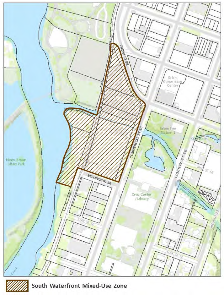
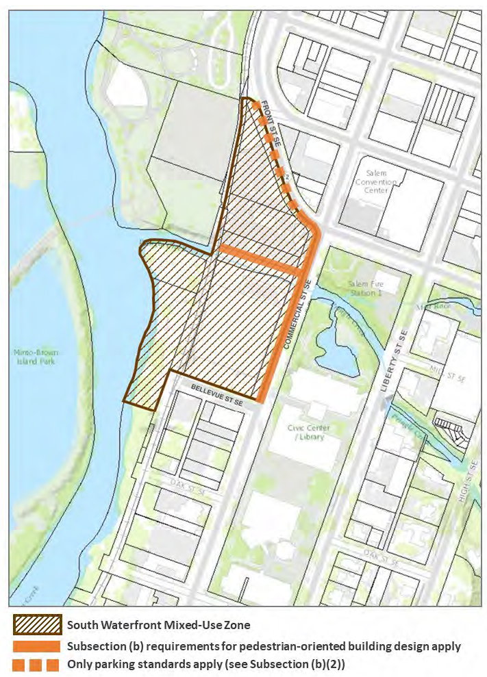
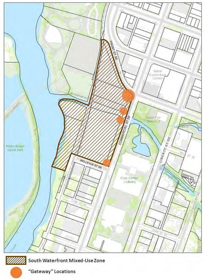
Pedestrian-oriented building design: general. The design standards set forth in this subsection apply to buildings throughout the entire south waterfront mixed-use zone (see Figure 531-1); provided, however, the design standards do not apply to building facades that are both facing and located within 80 feet of the railroad right-of-way.
FIGURE 531-1. SOUTH WATERFRONT MIXED-USE ZONE
(A)
Building facades.
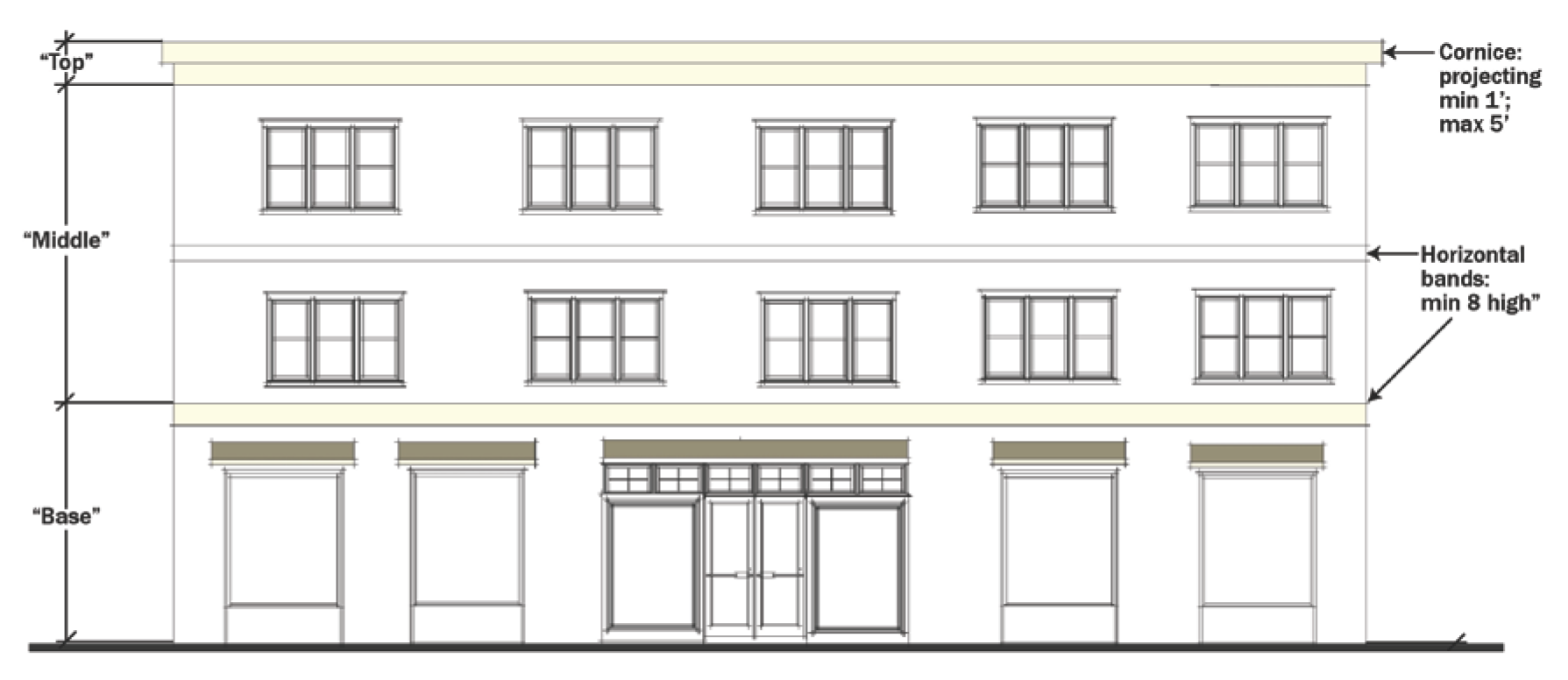
All buildings, regardless of height or number of stories, shall divide vertical mass into three clear and distinct zones: a base, middle, and top (see Figure 531-2). The base must at least encompass the first full building floor above grade. Vertical building mass shall be divided by using one or more of the following architectural detailing techniques to differentiate the base, middle, and top of the building:
(i)
Horizontal bands, such as string courses or projecting cornices. Horizontal bands shall be a minimum of eight inches in height and must project a minimum of three-fourth inch from the building facade. Cornices must project a minimum of one foot, but not more than five feet, from the facade of the building.
(ii)
Changes in building form/massing through the use of building offsets or projections measuring a minimum of three feet in depth.
(iii)
Changes in color, pattern, and/or material. If changes in color, pattern, and/or material are utilized as an architectural detailing technique, it must be used in combination with one or more of the other identified architectural detailing techniques.
FIGURE 531-2. DIVISION OF VERTICAL BUILDING MASS (BASE, MIDDLE, AND TOP)
(B)
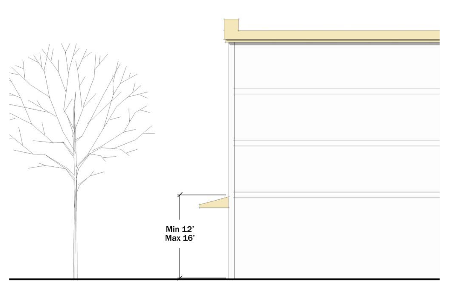
Ground floor height.
The ground floors of buildings along streets, or facing open space, shall be a minimum of 12 feet, but not more than 16 feet, in height (see Figure 531-3). For the purposes of this standard, ground floor height is measured from the top of the building foundation to the ceiling of the first floor.
FIGURE 531-3. GROUND FLOOR HEIGHT
(C)
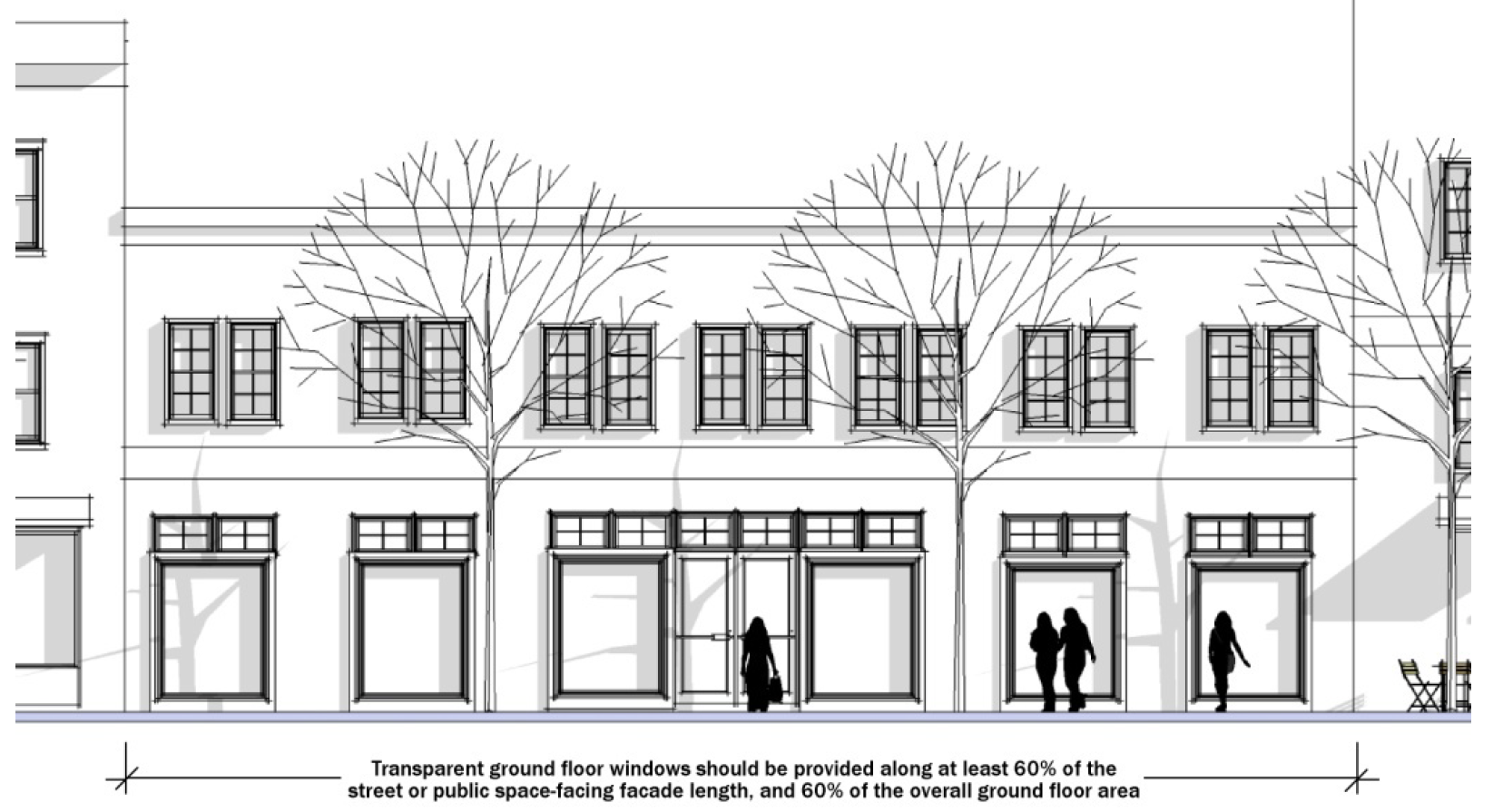
Building transparency.
(i)
Ground floor building facades facing streets and open space shall include transparent windows along a minimum of 60 percent of the length, and on a minimum of 60 percent of the overall area, of the ground floor facade (see Figure 531-4). This includes ground floor facades facing streets, Pringle Creek, public open spaces, and private open spaces such as forecourts or plazas. For purposes of this standard, ground floor facade area includes exterior wall areas up to 12 feet above finished grade. Loading and service areas, ground floor parking, one-half story below grade visible parking, above grade raised foundations, and ground floor residential dwelling units are exempt from this requirement.
(ii)
Ground floor windows shall have a minimum visible transmittance (VT) of 60 percent; provided, however, medical and dental offices may have tinted windows.
(iii)
Upper floor building facades facing streets and open space shall include vertically-oriented windows along a minimum of 30 percent of each building floor length, and on a minimum of 30 percent of the overall exterior wall area, of the upper floor facade.
FIGURE 531-4. BUILDING TRANSPARENCY
(D)
Primary building entries.
(i)
Primary building entries shall be comprised of a minimum of 40 percent transparent glass (see Figure 531-5). The glass shall have a minimum visible transmittance (VT) of 60 percent. Opaque doors are not permitted. Entries opening directly into individual residential dwellings are exempt from this requirement.
(ii)
Primary building entries shall:
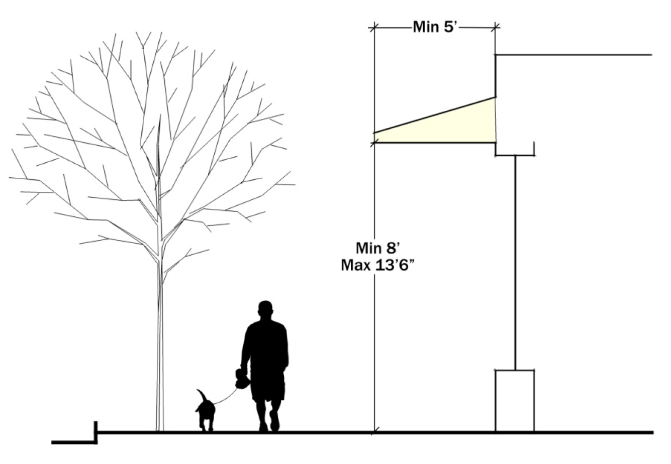
(aa)
Include weather protection, in the form of awnings or canopies. Awnings and canopies shall have a minimum depth of five feet, and shall have a minimum clearance height above the sidewalk of eight feet and a maximum clearance height above the sidewalk of 13 feet six inches (see Figure 531-6); or
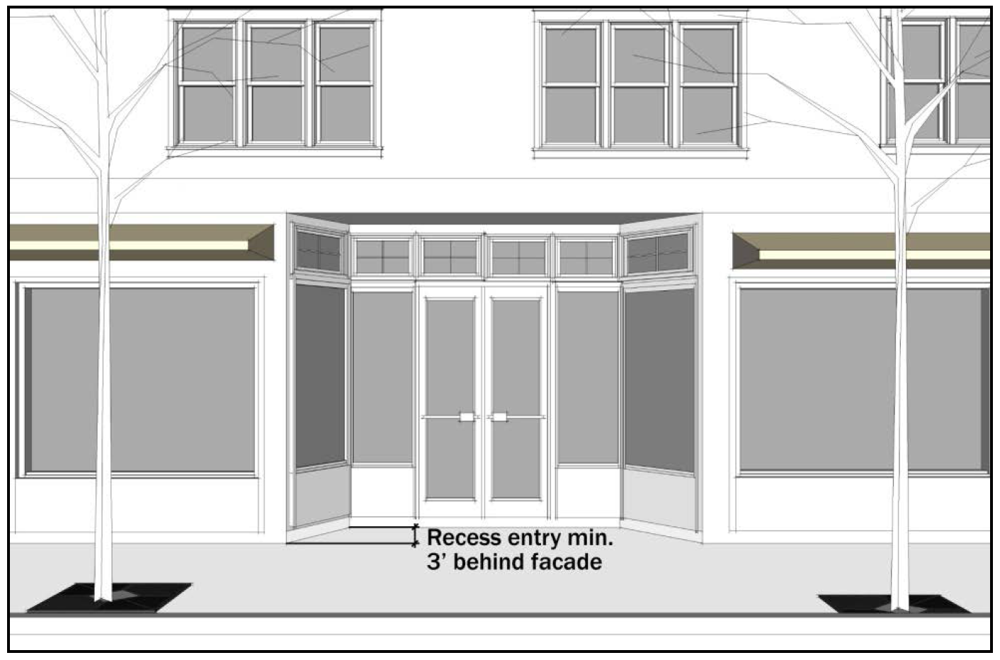
(bb)
Be recessed into the building facade a minimum depth of three feet (see Figure 531-7).
FIGURE 531-5. TRANSPARENT BUILDING ENTRIES
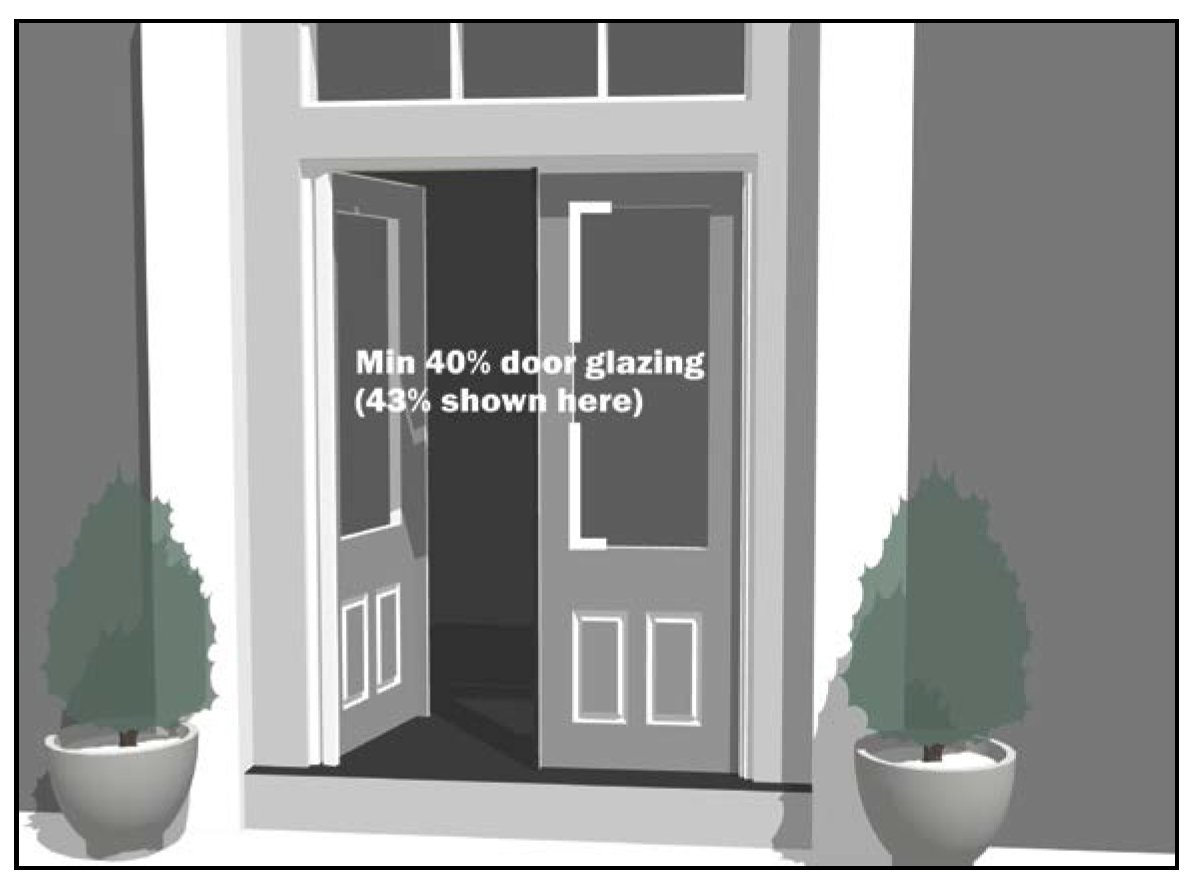
FIGURE 531-6. PRIMARY ENTRY AWNING/CANOPY DIMENSIONS
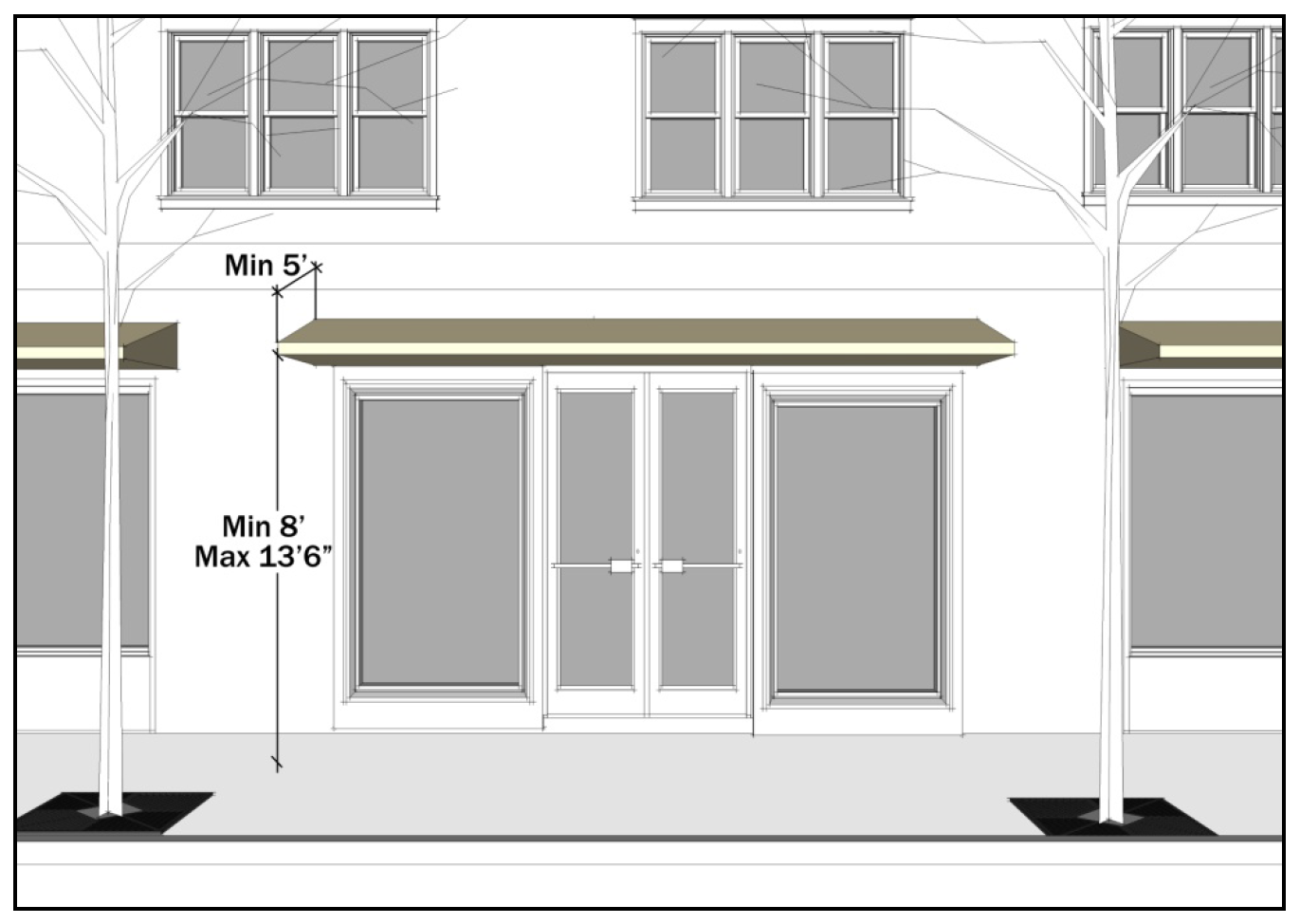
FIGURE 531-7. RECESSED ENTRY DIMENSIONS
(E)
Mechanical and service equipment.
(i)
Ground level mechanical and service equipment, such as garbage collection areas, recycling collection areas, and mechanical equipment, shall be screened with landscaping or a site obscuring fence or wall (see Figure 531-8). Ground level mechanical and service equipment and its associated screening shall be located so as to not be visible from public sidewalks and open spaces.
(ii)
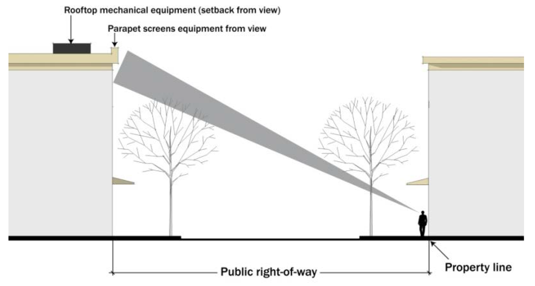
Rooftop mechanical equipment, with the exception of solar panels and wind generators, shall be setback and screened so as to not be visible to a person standing on the property line on the far side of any adjacent, at-grade public street (see Figure 531-9). All rooftop mechanical equipment shall be setback and screened so as to not be visible to a person standing 60 feet from the building within any adjacent public open space.
FIGURE 531-8. SCREENING OF GROUND LEVEL MECHANICAL AND SERVICE EQUIPMENT
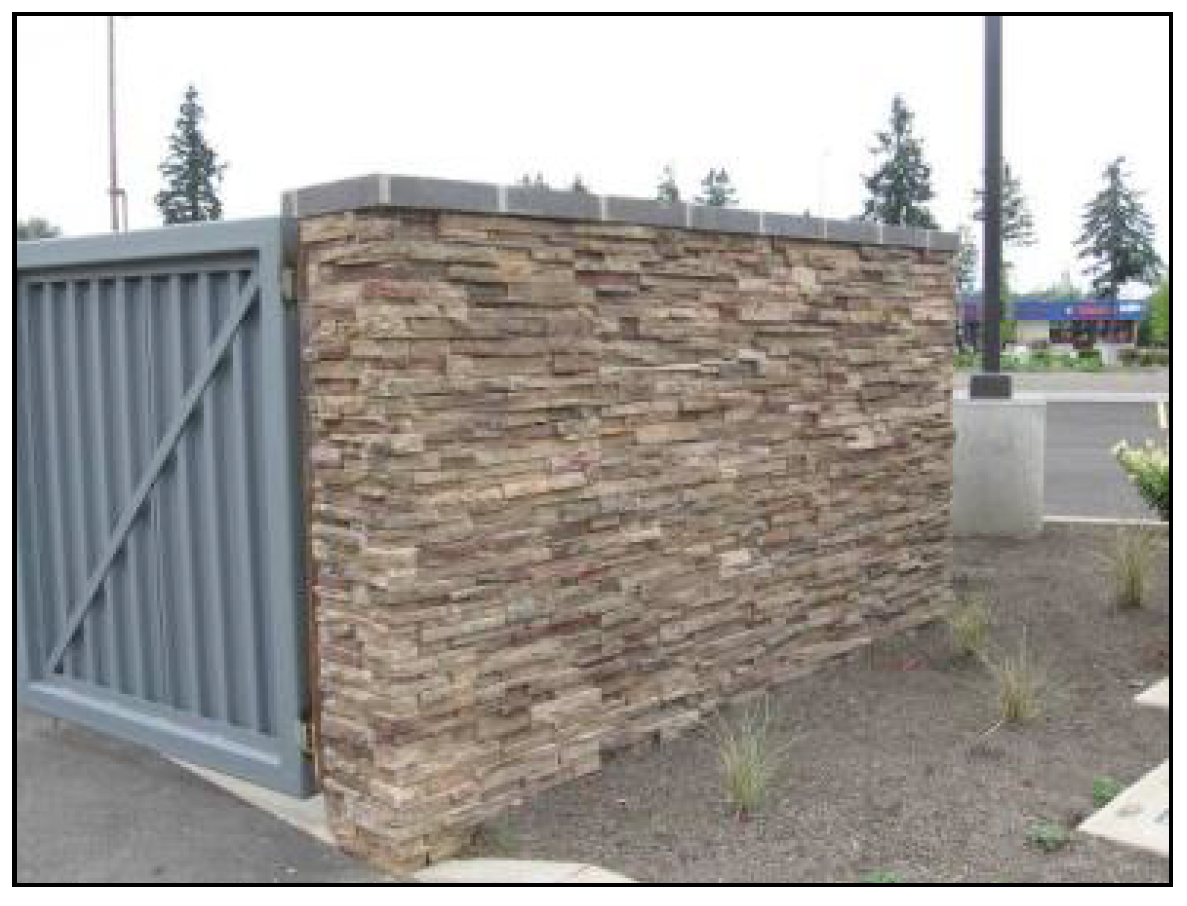
FIGURE 531-9. SCREENING OF ROOFTOP MECHANICAL EQUIPMENT
(2)
Pedestrian-oriented building design: specific. The design standards set forth in this subsection apply to buildings located along the north side of Pringle Creek, along Commercial Street, and at the corner of Commercial Street and Front Street (see Figure 531-10). The design standards applicable to parking included under subsection (d)(2)(B) of this section apply to all of the above frontages, and to the frontage along Front Street, as shown in Figure 531-10.
FIGURE 531-10. APPLICABILITY OF REQUIREMENTS FOR PEDESTRIAN-ORIENTED BUILDING DESIGN:
SPECIFIC
(A)
Building setbacks and frontages.
(i)
Except along Pringle Creek, buildings shall be oriented to the right-of-way, and shall be built to the front lot line contiguous with the right-of-way (see Figure 531-11). This standard applies to the first 25 feet or two stories of building height only. Above 25 feet or two stories in height, a building may be setback from the right-of-way.
(ii)
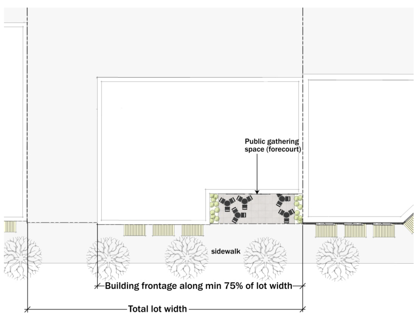
Along Front Street, or at identified "Gateway" corners, buildings may be set back up to 50 feet, provided the area within the setback is developed as a public plaza. In other locations, buildings may be setback up to 20 feet for not more than 50 percent of the length of the building facade, provided the area within the setback is developed as public or private gathering space, such as forecourts or plazas (see Figure 531-12).
(iii)
Buildings that are chamfered at the corner may be set back to the extent necessary to accommodate the chamfered corner.
(iv)
Upon redevelopment, and to the extent appropriate permitting agencies authorize, existing buildings over Pringle Creek shall be removed. Construction of new buildings over Pringle Creek is prohibited.
(v)
Along the north bank of Pringle Creek, buildings shall be set back a minimum of 20 feet from the creek.
(vi)
Lots fronting on Commercial Street or abutting Pringle Creek shall provide continuous building frontage along the public right-of-way and/or the creek face for a minimum of 75 percent of the width of the lot (see Figure 531-13).
(vii)
Primary building entrances shall be located either along Commercial Street, Front Street, or the north bank of Pringle Creek, or oriented to public street intersections or street corners. Primary building entrances shall be directly connected to the sidewalk.
FIGURE 531-11. BUILDINGS CONSTRUCTED CONTIGUOUS TO FRONT PROPERTY LINE
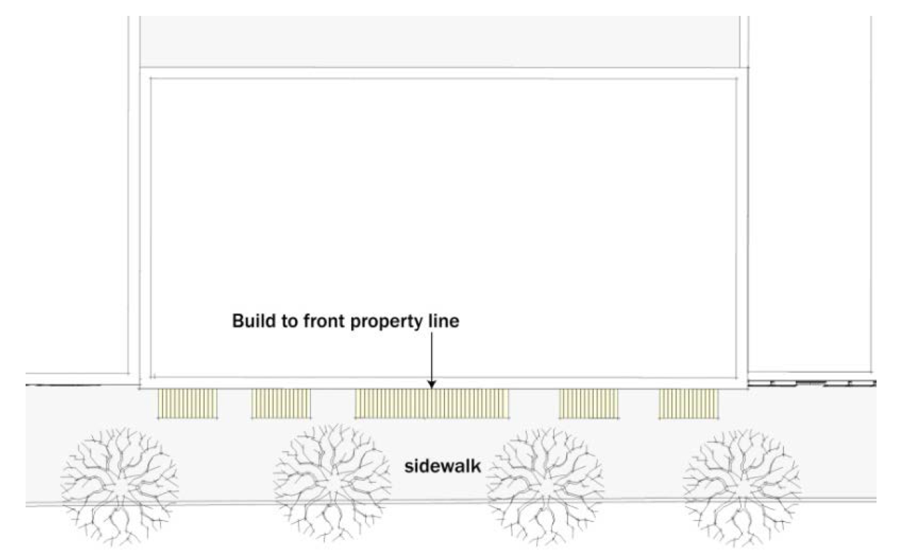
FIGURE 531-12. ADDITIONAL FRONT SETBACK FOR GATHERING SPACE
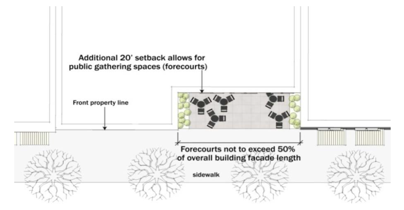
FIGURE 531-13. REQUIRED BUILDING FRONTAGE ALONG COMMERCIAL STREET AND PRINGLE CREEK
(B)
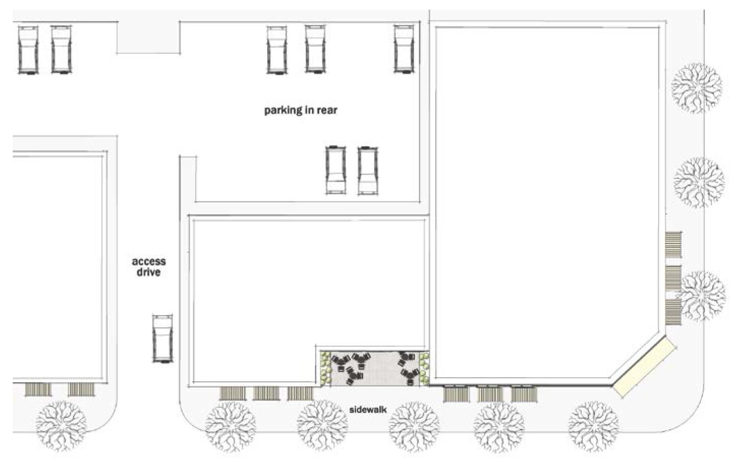
Parking.
(i)
Off-street parking is prohibited between buildings and the street, except along Front Street (see Figure 531-14). Along Front Street, disabled parking and passenger loading and unloading zones are permitted between buildings and the street.
(ii)
Parking structures fronting on Commercial Street or Front Street shall include space for ground floor commercial and/or household living uses along a minimum of 70 percent of their Commercial Street or Front Street facing facades.
FIGURE 531-14. SURFACE PARKING LOCATED BEHIND BUILDING
(C)
Weather protection.
(i)
Weather protection, in the form of awnings, canopies, arcades, or galleries, shall be provided along a minimum of 50 percent of the length of the ground floor building facade facing streets and public space.
(ii)
Awnings and canopies shall have a minimum depth of five feet, and shall have a minimum clearance height above the sidewalk of eight feet and a maximum clearance height above the sidewalk of 13 feet six inches (see Figure 531-15).
FIGURE 531-15. AWNING/CANOPY DIMENSIONS
(3)
Gateways. The design standards set forth in this subsection apply only to corner or "Gateway" locations identified in Figure 531-16.
FIGURE 531-16. APPLICABILITY OF REQUIREMENTS FOR GATEWAYS
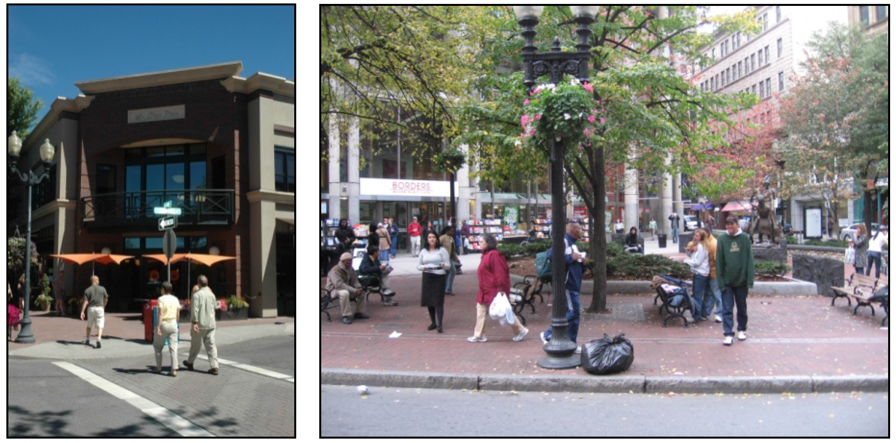
(A)
Corner treatments. Buildings located at corners and gateways shall incorporate architectural or site planning design elements that visually emphasize the corner of the building. One or more of the following techniques shall be used to meet this standard:
(i)
Prominent architectural elements that emphasize the corner of the building, including increased building height or massing, cupolas or turrets, or pitched roofs at the corner of the building (see Figure 531-17).
(ii)
"Signature" signage located at the corner of the building (see Figure 531-19).
(iii)
Public gathering spaces, such as plazas, located at the corner that incorporate visually distinct paving materials, site furnishings, and/or landscaping treatments (see Figure 531-20).
(iv)
Primary building entries located at chamfered corners (see Figure 531-18).
FIGURE 531-17. ARCHITECTURAL ELEMENTS THAT EMPHASIZE BUILDING CORNERS
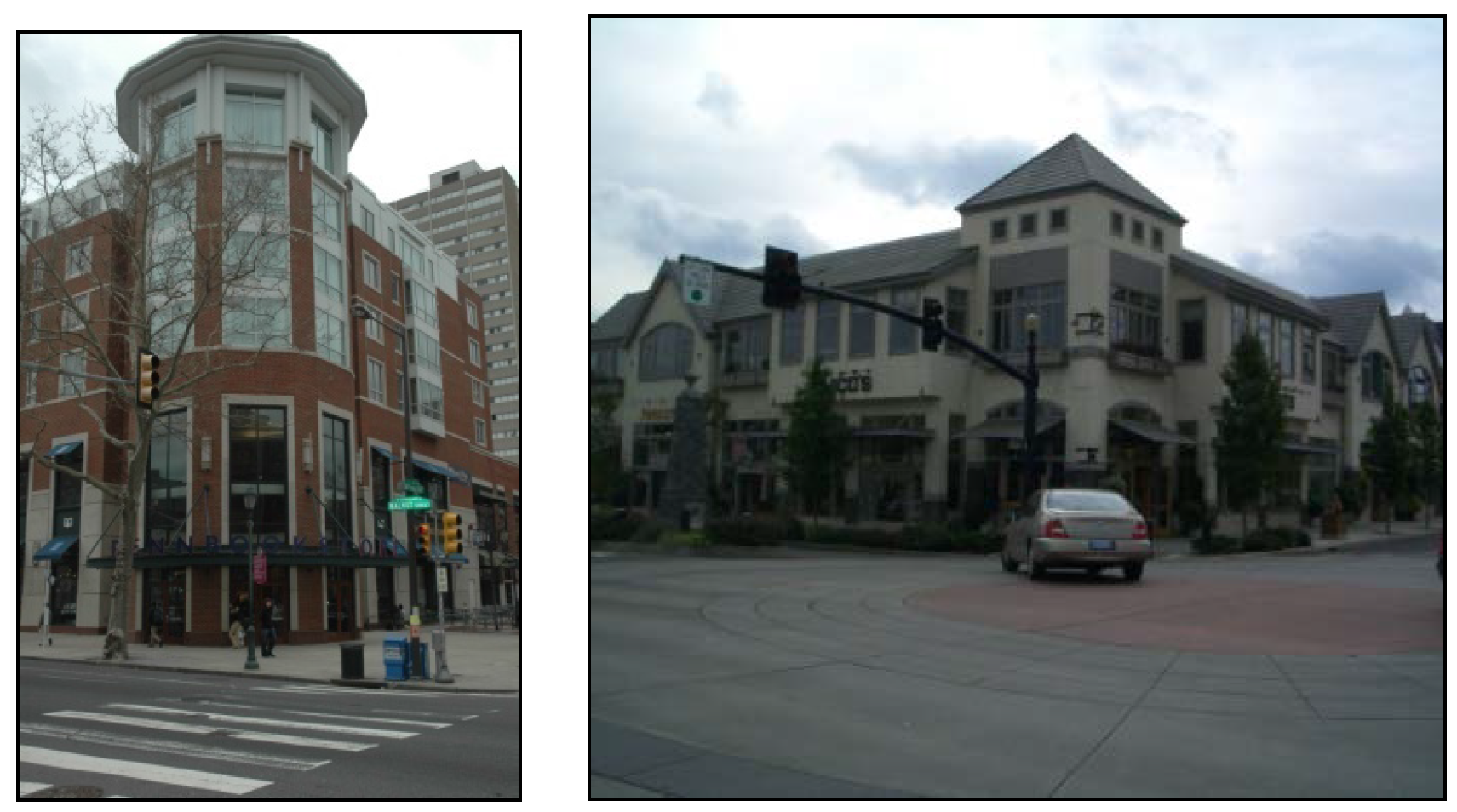
FIGURE 531-18. PRIMARY BUILDING ENTRY LOCATED AT CHAMFERED BUILDING CORNER
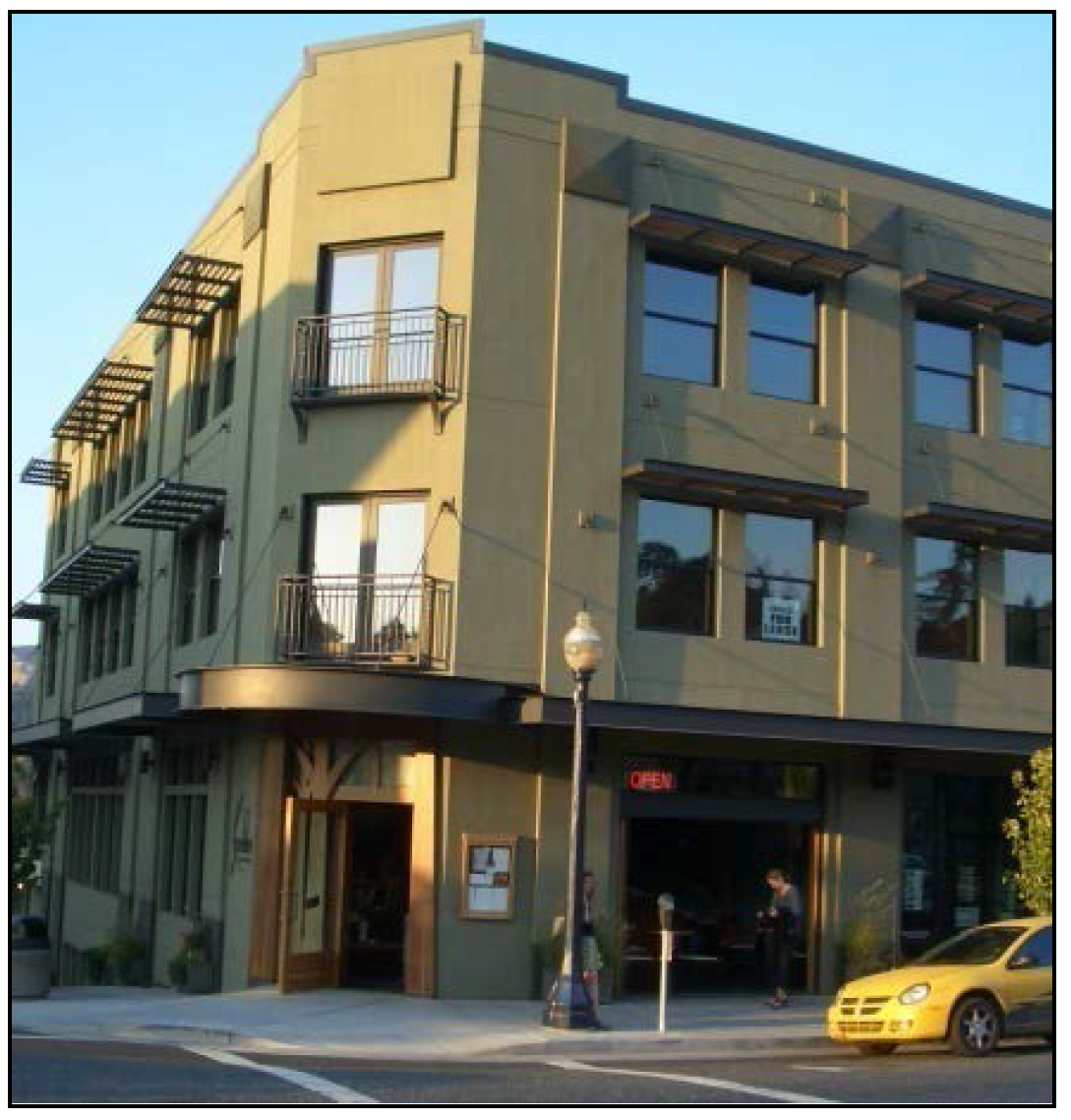
FIGURE 531-19. "SIGNATURE" SIGNAGE AT BUILDING CORNER
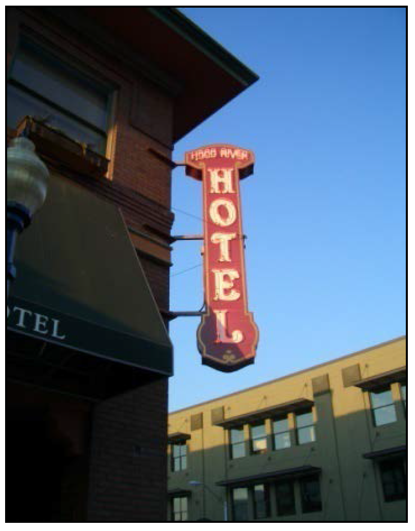
FIGURE 531-20. PUBLIC GATHERING SPACES AT BUILDING CORNERS
(4)
Pedestrian connections. The design standards set forth in this subsection apply to developments along the north bank of Pringle Creek, as identified in Figure 531-21.
FIGURE 531-21. REQUIRED PEDESTRIAN CONNECTIONS
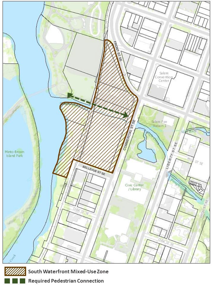
(A)
Required pedestrian connections.
(i)
Along the north bank of Pringle Creek:
(aa)
An easement or public dedication a minimum of 10 feet in width shall be provided promoting connectivity for non-vehicular traffic that is accessible from the sidewalk along Commercial Street and connects to Riverfront Park; or
(bb)
At least one public pedestrian connection a minimum of 10 feet in width shall be provided that connects to the sidewalk along Commercial Street at street level.
(ii)
A pedestrian connection shall be provided to connect the west sidewalk along Commercial Street to established pedestrian paths in Riverfront Park.
(Prior Code, § 531.025; Ord. No. 31-13; Ord. No. 8-24, § 1(Exh. A), 9-23-2024)
Sec. 531.030. - Reserved.
Editor's note— Ord. No. 8-24, § 1(Exh. A), adopted Sept. 23, 2024, repealed § 531.030, which pertained to design review and derived from prior Code, § 531.030; Ord. No. 31-13 and Ord. No. 6-19, § 1(Exh. A), adopted June 24, 2019, eff. 7-24-2019.
Sec. 531.035. - Reserved.
Editor's note— Ord. No. 8-24, § 1(Exh. A), adopted Sept. 23, 2024, repealed § 531.030, which pertained to design review guidelines and design review standards and derived from prior Code, § 531.035; Ord. No. 31-13; Ord. No. 13-21, § 1(Exh. A), adopted Feb. 14, 2022
Sec. 531.040. - Other provisions.
In addition to the standards set forth in this chapter, development within the SWMU zone must comply with all other applicable development standards of the UDC, including, but not limited to, the following chapters:
(a)
Trees and Shrubs: SRC chapter 86.
(b)
Wireless Communications Facilities: SRC chapter 703.
(c)
General Development Standards: SRC chapter 800.
(d)
Public Improvements: SRC chapter 802.
(e)
Streets and Right-of-Way Improvements: SRC chapter 803.
(f)
Driveway Approaches: SRC chapter 804.
(g)
Vision Clearance: SRC chapter 805.
(h)
Off-Street Parking, Loading and Driveways: SRC chapter 806.
(i)
Landscaping and Screening: SRC chapter 807.
(j)
Preservation of Trees and Vegetation: SRC chapter 808.
(k)
Wetlands: SRC chapter 809.
(l)
Landslide Hazards: SRC chapter 810.
(m)
Sign Code: SRC chapter 900.
(Prior Code, § 531.040; Ord. No. 31-13)