
Salem City Zoning Code
CHAPTER 618
CHEMAWA-I-5 NORTHEAST QUADRANT GATEWAY OVERLAY ZONE
Sec. 618.001.- Purpose.
The purpose of the Chemawa/I-5 Northeast Quadrant Gateway Overlay Zone is to identify allowed uses and to establish development standards to provide a gateway to Salem.
(Prior Code, § 618.001; Ord. No. 31-13)
Sec. 618.005. - Chemawa/I-5 Northeast Quadrant Gateway Overlay Zone boundary.
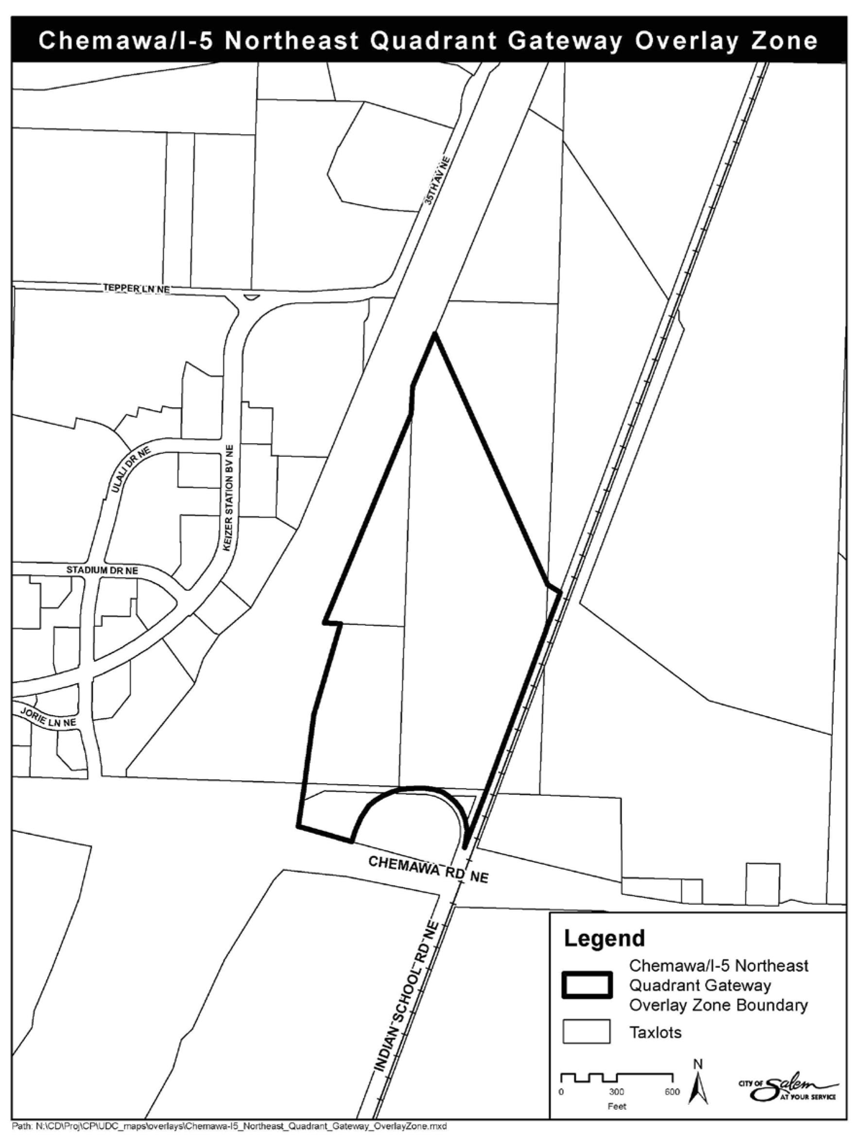
The boundaries of the Chemawa/I-5 Northeast Quadrant Gateway Overlay Zone are shown in Figure 618-2.
(Prior Code, § 618.005; Ord. No. 31-13)
Sec. 618.010. - Uses.
Except as otherwise provided in this section, any use that is a permitted, special, conditional, or prohibited use in the underlying zone is a permitted, special, conditional, or prohibited use in the Chemawa/I-5 Northeast Quadrant Gateway Overlay Zone.
(a)
Additional prohibited uses. In addition to the prohibited uses in the underlying zone, the uses set forth in Table 618-1 are additional prohibited (N) uses in the Chemawa/I-5 Northeast Quadrant Gateway Overlay Zone.
(Prior Code, § 618.010; Ord. No. 31-13)
Sec. 618.015. - Development standards.
Development within the Chemawa/I-5 Northeast Quadrant Gateway Overlay Zone must comply with the development standards applicable in the underlying zone and the development standards set forth in this section. The development standards in this section are in addition to, and not in lieu of, all other applicable development standards in the underlying zone. Where the development standards in this section conflict with the development standards applicable in the underlying zone, the development standards in this section shall be the applicable development standard.
(a)
Declaration of transportation and public infrastructure demands. If a use is proposed for property, or any portion of a property, within the Chemawa/I-5 Northeast Quadrant Gateway Overlay Zone that is different from that presented in the pre-annexation analysis, the applicant shall provide the following information:
(1)
A transportation impact analysis demonstrating that development for the entire Chemawa/I-5 Northeast Quadrant Gateway Overlay Zone can be completed without exceeding the design capacity of the Chemawa/I-5 Interchange and the local and regional transportation network; and
(2)
An analysis demonstrating that development for the entire Chemawa/I-5 Northeast Quadrant Gateway Overlay Zone can be completed without exceeding the water and sewer allocations in the water system master plan and the Salem Area Wastewater Management Master Plan.
(b)
Overlay zone boundary setbacks. Setbacks from the boundary of the Chemawa/I-5 Northeast Quadrant Gateway Overlay Zone shall be provided as set forth in this subsection.
(1)
A minimum 20-foot setback shall be provided from the boundary of the Chemawa/I-5 Northeast Quadrant Gateway Overlay Zone. For purposes of establishing standards for designated areas within the minimum required overlay zone boundary setback, the following overlay zone boundary setback areas are established:
(A)
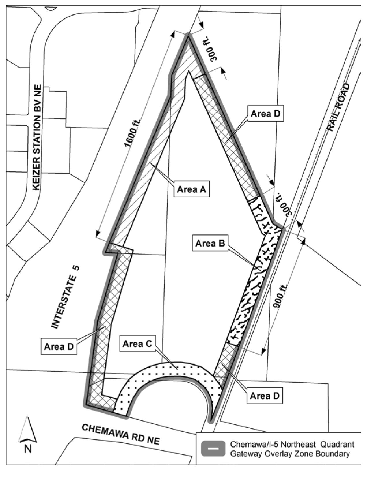
Area A. Area A, as set forth in Figure 618-1, includes 1,600 feet of frontage along Interstate-5 and 300 feet frontage along the north overlay zone boundary.
(B)
Area B. Area B, as set forth in Figure 618-1, includes 300 feet of frontage along the north overlay zone boundary and 900 feet of frontage along the railroad.
(C)
Area C. Area C, as set forth in Figure 618-1, includes the road frontage connecting Indian School Road NE and Chemawa Road NE.
(D)
Area D. Area D, as set forth in Figure 618-1, includes those overlay zone boundary setback areas not included within Areas A, B, or C.
FIGURE 618-1. OVERLAY ZONE BOUNDARY SETBACK AREAS
(2)
In addition to the minimum overlay zone boundary setback set forth in subsection (b)(1) of this section, structures greater than 20 feet in height shall be set back from the minimum overlay zone boundary setback a minimum of one foot for each one foot of height greater than 20 feet.
(3)
No structures, signs, vehicle use areas, or outdoor storage areas are allowed within the minimum overlay zone boundary setback; provided, however, parking areas may encroach not more than ten feet into overlay zone boundary setback Area C (see Figure 618-1).
(4)
Recreational equipment, furniture, sidewalks, and pedestrian connections are allowed within the overlay zone boundary setback.
(5)
Sight-obscuring fences, walls, hedges, or berms are not allowed within the overlay zone boundary setback; provided, however, landscaped berms not more than four feet in height are allowed within the overlay zone boundary setback.
(6)
Non-sight-obscuring fences not more than eight feet in height are allowed within the overlay zone boundary setback. Such fences shall be integrated into the landscaping so as to minimize the visual impact of the fence.
(c)
Open space. A minimum of 20 percent of the gross area of each lot, or the Chemawa/I-5 Northeast Quadrant Gateway Overlay Zone as a whole if developed as a single project, shall be designated as open space. Required setbacks and other required landscaped areas may be counted towards meeting the minimum open space requirement.
(d)
Landscaping. Landscaping shall conform to the standards set forth in SRC chapter 807, together with the standards set forth in this subsection.
(1)
Overlay zone boundary setback landscaping. The overlay zone boundary setback, excluding any portion of which is located within designated wetlands, shall be landscaped with a mixture of trees, shrubs, hedges, turf, and vegetative ground cover in conformance with the standards set forth in this subsection.
(A)
Landscaping within the overlay zone boundary setback shall conform to the plant unit (PU) densities set forth in Table 618-2.
(B)
Plant units may be distributed or clustered within the overlay zone boundary setback. If clustering of plant units is used to create visual corridors within the overlay zone boundary setback, the visual corridors shall be no wider than 150 feet. For purposes of this subsection, the term "visual corridor" means an area with no landscaping, or landscaping with a plant unit density of less than one plant unit per 49 square feet, that is located between landscaped areas each consisting of at least 20 plant units and a least one shade tree or two conifer trees.
(C)
Within 15 years of planting, all new trees shall provide canopy coverage to at least 35 percent of the overly zone boundary setback area.
(2)
Landscaping abutting non-articulated building facades. Where a building facade exceeds 70 feet in length without openings or articulation, vertical landscaping shall be provided in conformance with the standards set forth in this subsection to lessen the visual bulk of the building facade. For purposes of this subsection, the term "openings" does not include windows or doorways; and the term "articulation" means a minimum two-foot deep vertical or horizontal offset within the building facade.
(A)
Vertical landscaping shall be provided in the minimum amount of ten plant units for every 70 linear feet of non-articulated building facade.
(B)
A minimum of 75 percent of the vertical landscaping shall consist of shade, conifer, evergreen, or ornamental trees.
(C)
Vertical landscaping shall be located abutting, and centered within, the non-articulated portion of the building facade.
(3)
Off-street parking area landscaping. A minimum of ten percent of the interior of each parking area shall be landscaped. The landscaping shall be distributed throughout the parking area within landscape islands in conformance with the standards set forth in this subsection.
(A)
Landscape islands shall have a minimum planting area of 25 square feet, and shall have no dimension less than five feet.
(B)
Shade trees shall be distributed throughout the parking area so that no parking space is more than 35 feet from the trunk of a shade tree.
(C)
Turf, vegetative ground cover, or decorative bricks must completely cover the remaining area of any landscape island not covered by shrubs.
(D)
Landscape islands shall be protected from vehicular damage by a minimum six-inch-high curb.
(4)
Open space landscaping.
(A)
Designated open space, excluding any portions of which are located within designated wetlands, where living vegetation has been removed or damaged, or where earth has been disturbed by the development process, shall be landscaped with a mixture of trees, shrubs, hedges, turf, and vegetative ground cover.
(B)
No single tree species shall comprise more than 34 percent of new trees planted.
(5)
Off-street loading area screening. All loading spaces, docks, doors, and bays shall be screened from the overlay zone boundary setback and adjacent property by a minimum six-foot-high sight-obscuring fence, wall, hedge, or berm.
(e)
Outdoor storage. Outdoor storage areas shall comply with the following:
(1)
Outdoor storage areas shall not be located within 20 feet of overlay zone boundary setback Areas A, B, or C.
(2)
Outdoor storage areas larger than one acre in size shall include a minimum of six permanent interior landscape islands, plus one additional permanent interior landscape island for each one-half acre of outdoor storage area sized over one acre. The permanent interior landscape islands shall:
(A)
Have a minimum planting area of 25 square feet, with no dimension less than five feet;
(B)
Be planted with a minimum of 15 plant units; and
(C)
Be protected from vehicular damage by a minimum six-inch-high curb or barrier.
(3)
Vehicle access and maneuvering areas within outdoor storage areas shall be dust free.
(f)
Transportation.
(1)
An internal pedestrian network shall be provided within the Chemawa/I-5 Northeast Quadrant Gateway Overlay zone that:
(A)
Provides connectivity between primary buildings, parking areas, and designated open space; and
(B)
Provides connectivity to transit on Chemawa Road NE and to Indian School Road NE.
(2)
Development of a transit stop on Chemawa Road NE stall be addressed in the transportation impact analysis for development.
(3)
The internal transportation network of the Chemawa/I-5 Northeast Quadrant Gateway Overlay Zone shall encourage and accommodate freight movement by truck and rail.
FIGURE 618-2. CHEMAWA I-5 NORTHEAST QUADRANT GATEWAY OVERLAY ZONE
(Prior Code, § 618.015; Ord. No. 31-13)

