
Salem City Zoning Code
CHAPTER 530
FMU—FAIRVIEW MIXED-USE
Sec. 530.001.- Purpose.
The purpose of the Fairview Mixed-Use (FMU) Zone is to implement the mixed-use designation of the Salem Area Comprehensive Plan by establishing a master planning process through which allowed uses are identified and standards for development within the zone are established that:
(a)
Encourage innovative planning resulting in mixed-use development, improved protection of open spaces and natural features, and greater housing and transportation options;
(b)
Encourage the innovative integration of park and school uses;
(c)
Encourage developments that recognize the relationship between buildings, their use, open space, and infrastructure; providing varied opportunities for innovative and diversified living environments in line with the principles of sustainable development and sustainable business practices;
(d)
Support affordable housing options and mixed-income neighborhoods;
(e)
Facilitate the resourceful use of land through the arrangement of land uses, buildings, circulation systems, open space, and infrastructure;
(f)
Encourage economic opportunity;
(g)
Preserve, to the greatest extent possible, existing natural areas and open space that may not otherwise be protected through conventional development;
(h)
Recognize and preserve the historical and archeological significance of buildings, structures, and sites, and encourage historic resource designation of those buildings, structures, and sites that merit official recognition; and
(i)
Encourage energy conservation and improved air and water quality.
(Prior Code, § 530.001; Ord. No. 31-13; Ord. No. 3-22, § 1(Exh. A), 2-28-2022)
Sec. 530.005. - Definitions.
The following words, terms and phrases, when used in this chapter, shall have the meanings ascribed to them in this section, except where the context clearly indicates a different meaning:
Building footprint means the total area enclosed by the exterior walls of a building at ground level, exclusive of courtyards.
Development means the construction or demolition of a building or structure; or alterations or improvements to the land, including, but not limited to, grading, for the purposes of enhancing its economic value or productivity.
Master plan means a comprehensive long-range plan intended to guide the growth and development of a region and that includes analysis, recommendations, and proposals for the region's population, economy, housing, transportation, community facilities, natural resources, and land use.
Mixed-use building means a single building containing a combination of residential and non-residential uses.
Natural open space means open space consisting of natural landscape set aside for the purpose of preservation or conservation of natural resources, natural features, habitat, or scenic/aesthetic values. Natural open space may include paths and trails.
(Prior Code, § 530.005; Ord. No. 31-13; Ord. No. 3-22, § 1(Exh. A), 2-28-2022)
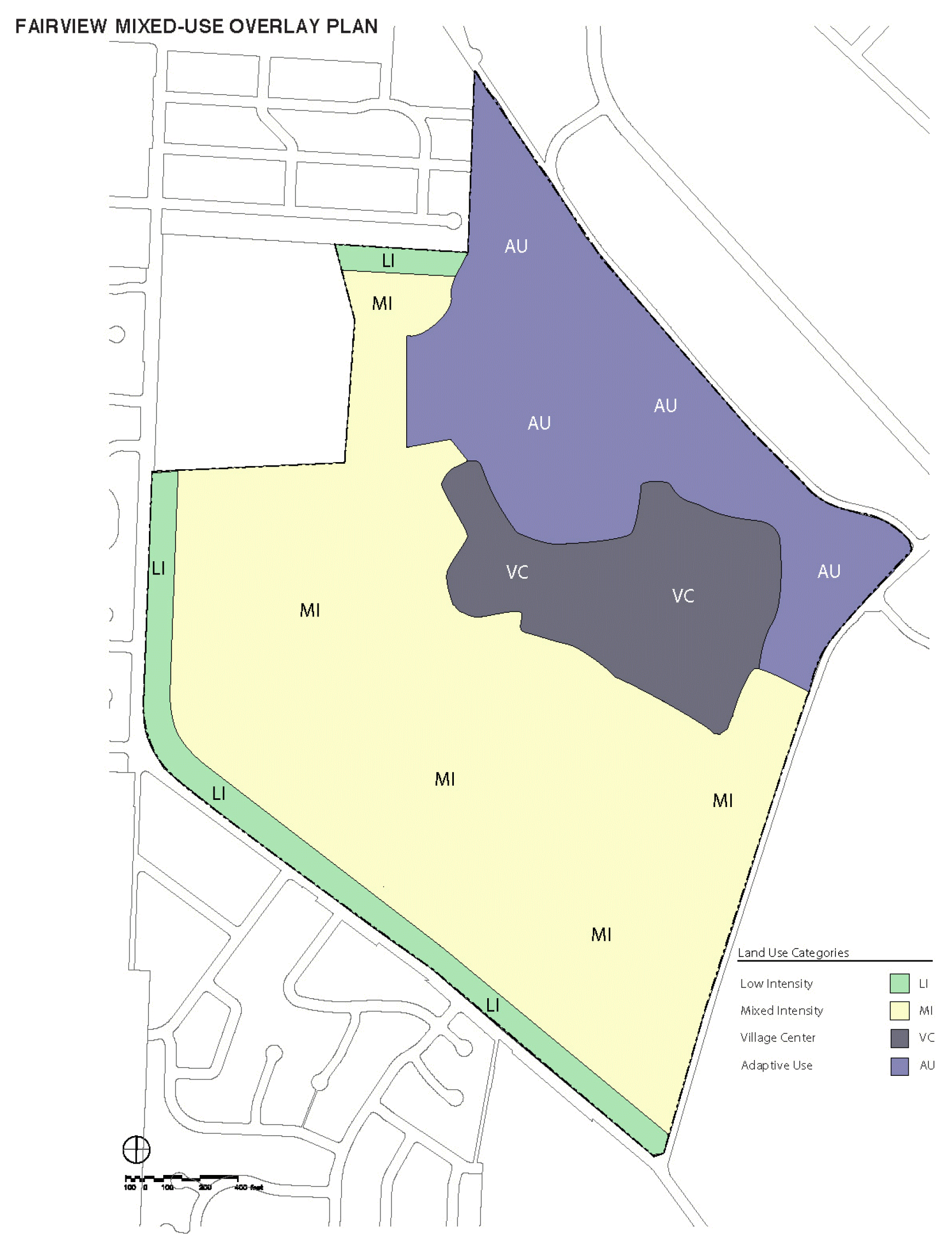
Sec. 530.010. - Overlay areas.
For the purpose of regulating development within the FMU zone, the following overlay areas, identified in Figure 530-1, are established:
(a)
Low-intensity residential (LI). The low-intensity residential area comprises single family activities in detached housing types sited on separate lots with private yards and street and/or alley access. Nonresidential uses, except for a few limited exceptions, are prohibited.
(b)
Mixed-intensity (MI). The mixed-intensity area comprises primarily residential uses, along with a mix of small-scale neighborhood commercial, employment, and public services uses. Buildings will be a mix of one-story to three-story detached, attached, or stacked housing types sited on smaller individually-owned lots with private yards and street and/or alley access, or larger lots under multiple or separate ownership with shared street and/or alley access. Townhouse development is appropriate at the higher density range.
(c)
Adaptive use (AU). The adaptive use area is intended to comprise the highest concentration of existing buildings and historic development patterns. Residential and nonresidential development within this area may occur within existing structures that have been rehabilitated or within new structures.
(d)
Village center (VC). The village center area comprises the most intense and pedestrian-oriented residential, commercial, employment, and public services uses. Residential uses will have densities of no less than 16 dwelling units per net acre. Nonresidential uses include a mix of large and small scale commercial establishments, which cumulatively will be limited to not more than approximately 80,000 square feet of pedestrian-oriented retail. Office uses are encouraged.
(Prior Code, § 530.010; Ord. No. 31-13)
Sec. 530.015. - Development within the FMU zone.
All development within the FMU zone shall be undertaken pursuant to the Fairview plan, a refinement plan, and the development standards set forth in this chapter.
(Prior Code, § 530.015; Ord. No. 31-13; Ord. No. 3-22, § 1(Exh. A), 2-28-2022)
Sec. 530.020. - Fairview plan.
The Fairview plan is a master plan that identifies the goals and policies for development within the FMU zone.
(a)
Applicability. An approved Fairview plan shall be required prior to the approval of any refinement plan.
(b)
Procedure type. An application for the Fairview plan is processed as a Type III procedure under SRC chapter 300.
(c)
Submittal requirements. In addition to the submittal requirements for a Type III application under SRC chapter 300, an application for the Fairview plan shall include the following in the form of map(s), text, or both, as applicable:
(1)
A description of the purpose, main concepts, goals, policies, and general development guidelines for development within the FMU zone in light of the purpose of this chapter.
(2)
A conceptual open space plan for the entire FMU zone identifying an integrated network of open spaces for the purpose of preserving and enhancing identified natural drainage patterns, significant trees and vegetation, and wetlands; responding to significant topographical features; and providing opportunities for active and passive recreation.
(3)
A conceptual transportation and mobility plan for the entire FMU zone addressing the integration of pedestrian, transit, and vehicular use on the site and providing safe and efficient pedestrian, bicycle, and other non-single occupancy vehicle (SOV) mobility; promoting transit; and reducing SOV trips.
(4)
A transportation impact analysis (TIA) of the major transportation and circulation elements intended to serve the FMU zone.
(5)
A site analysis, which shall include the following:
(A)
Identification of significant natural and built constraints of the site and surroundings;
(B)
Identification of existing and potential transit connections;
(C)
Identification of adjacent parcels and structures within 150 feet of the FMU zone boundary;
(D)
On-site open space, recreational facilities, parks, and trails;
(E)
Identification and delineation of existing natural resources, including, but not limited to, wetlands, as identified on the Local Wetlands Inventory, perennial and intermittent streams, and significant tree stands or groves. Proposed methods for the preservation or conservation of these resources shall be identified, with attention given to the Natural Resource Guidelines under 530.065;
(F)
Identification of existing structures, roads, and other development;
(G)
Identification of existing provisions for city infrastructure and utilities;
(H)
Identification of area hydrology and water resources;
(I)
Identification of existing topography and slope;
(J)
General geologic character of the site;
(K)
Identification of general soil types on the site;
(L)
Identification and visual analysis of area viewsheds; and
(M)
An inventory of buildings, structures, sites, objects, and known archeological sites which possess the criteria for historic resource designation under SRC chapter 230. The inventory shall identify any buildings, structures, sites, objects, or known archeological sites for which official historic resource designation will be sought. The inventory may identify any buildings, structures, or sites designated by the applicant as "historically significant" that may be adaptively reused or renovated, but for which historic resource designation will not be sought.
(d)
Criteria. The Fairview plan shall be approved if all of the following criteria are met:
(1)
The plan conforms to the applicable provisions of the Salem Area Comprehensive Plan.
(2)
The plan is compatible with adjoining land uses.
(3)
The plan is physically feasible, given consideration of existing or proposed infrastructure and public services.
(4)
The plan conforms to the following goals:
(A)
Encourage mixed-use development, improved protection of open spaces and natural features, and greater housing and transportation options;
(B)
Encourage the innovative integration of park and school uses;
(C)
Encourage the principles of sustainable development and sustainable business practices;
(D)
Support affordable housing options and mixed-income neighborhoods;
(E)
Facilitate the resourceful use of land through the efficient arrangement of land uses, buildings, circulation systems, open space and infrastructure;
(F)
Encourage economic opportunities that comply with and support business practices;
(G)
Recognize the historic significance of buildings, structures, and sites, including archaeological sites, through appropriate means, including, but not limited to, obtaining official historic resource designation; and
(H)
Encourage energy conservation and improved air and water quality.
(Prior Code, § 530.020; Ord. No. 31-13; Ord. No. 3-22, § 1(Exh. A), 2-28-2022)
Sec. 530.025. - Amendments to the Fairview plan.
(a)
Applicability. An amendment to the Fairview plan is an amendment to the text and/or supporting documents of the plan. Except as provided under SRC 530.030 for the approval of refinement plans, no amendment to the Fairview plan shall be made without receiving approval as set forth in this section.
(b)
Standing to initiate Fairview plan amendment. An amendment to the Fairview plan may only be initiated by an owner of property within the FMU zone, or that owner's agent, the Council, or the Planning Commission.
(c)
Procedure type. An amendment to the Fairview plan is processed as a Type III procedure under SRC chapter 300, unless the amendment is initiated by the City. An amendment to the Fairview plan initiated by the City is processed as a Type IV procedure under SRC chapter 300.
(d)
Submittal requirements. In addition to the submittal requirements for a Type III application under SRC chapter 300, an application for an amendment to the Fairview plan shall include:
(1)
The specific amendment proposed; and
(2)
A statement documenting the need for the amendment.
(e)
Criteria. An amendment to the Fairview plan shall be approved if all of the following criteria are met:
(1)
The proposed amendment conforms to the applicable provisions of the Salem Area Comprehensive Plan.
(2)
The proposed amendment is compatible with adjoining land uses and will not unreasonably impact surrounding existing or potential uses or development.
(3)
The proposed amendment is physically feasible, given consideration of existing or proposed infrastructure and public services.
(4)
The proposed amendment conforms to the following goals:
(A)
Encourage mixed-use development, improved protection of open spaces and natural features, and greater housing and transportation options;
(B)
Encourage the innovative integration of park and school uses;
(C)
Encourage the principles of sustainable development and sustainable business practices;
(D)
Support affordable housing options and mixed-income neighborhoods;
(E)
Facilitate the resourceful use of land through the efficient arrangement of land uses, buildings, circulation systems, open space and infrastructure;
(F)
Encourage economic opportunities that comply with and support business practices;
(G)
Recognize the historic significance of buildings, structures, and sites, including archaeological sites, through appropriate means, including, but not limited to, obtaining official historic resource designation; and
(H)
Encourage energy conservation and improved air and water quality.
(Prior Code, § 530.025; Ord. No. 31-13; Ord. No. 3-22, § 1(Exh. A), 2-28-2022)
Sec. 530.030. - Refinement plans.
Refinement plans are detailed regulatory plans that further refine and implement the Fairview plan in specific areas of the FMU zone based on more detailed site planning, design, and engineering than was conducted with the Fairview Plan. Refinement plans act as amendments to the Fairview plan for the specific affected area of the FMU zone and become the controlling document for development within the refinement plan area. Standards and processes stipulated in an approved refinement plan supersede the standards and processes of the UDC and shall be used as review criteria for any specific development proposal within the area covered by the refinement plan.
(a)
Applicability. An approved refinement plan shall be required prior to development within the FMU zone.
(b)
Minimum refinement plan area. The area subject to a refinement plan shall contain no less than 40 acres.
(c)
Procedure type. An application for a refinement plan is processed as a Type III procedure under SRC chapter 300.
(d)
Submittal requirements. In addition to the submittal requirements for a Type III application under SRC chapter 300, an application for a refinement plan shall include the following in the form of map(s), text, or both, as applicable:
(1)
An Illustrative site plan;
(2)
An identification of those land uses allowed under SRC 530.040 that are proposed to be allowed in the refinement plan area;
(3)
A general allocation and identification of major proposed land uses, including residential by density range, nonresidential, open space, and recreational land uses;
(4)
The name, location, and width of existing streets located within the refinement plan area;
(5)
The name, location, and width of proposed streets located within the refinement plan area;
(6)
Typical street cross-sections;
(7)
Detailed standards governing development within the refinement plan area, such as:
(A)
Performance standards and standards for development densitites;
(B)
Building and accessory structure height;
(C)
Floor area and FAR;
(D)
Open space;
(E)
Lot area and lot coverage; and
(F)
Landscaping and other site improvements.
(8)
Standards for the conservation, development, or utilization of natural resources, including surface water, soils, vegetation, and wildlife;
(9)
An identification and inventory of all wetland and riparian resources and all intermittent and perennial waterways;
(10)
An identification and inventory of all trees regulated under SRC chapter 808;
(11)
Where applicable, the proposed methods of protection or conservation of natural features, historic structures, and view sheds;
(12)
Proposed method for the perpetual maintenance of any common open space and common facilities;
(13)
Standards and responsibilities for maintenance of infrastructure and whether the infrastructure is to be public or private;
(14)
Standards for phasing and construction of streets proposed within the refinement plan area, or needed for servicing the area, as identified in the required studies submitted with the refinement plan;
(15)
Location and extent of proposed provision for sewage disposal, effluent use, stormwater drainage, and utilities;
(16)
Standards for the phasing and construction of sewage disposal, effluent use, stormwater drainage, solid waste disposal, and public utilities, as identified in the required studies submitted with the refinement plan;
(17)
A phasing plan for the following, as applicable:
(A)
The preservation of site features established by the Fairview plan;
(B)
The development of the refinement plan area; and
(C)
The construction, dedication, and provision of infrastructure and public services;
(18)
A draft form of financial assurances to be recorded prior to refinement plan approval;
(19)
A detailed explanation of how and to what extent the refinement plan is to supplement or supersede city standards;
(20)
Standards for the interpretation of the refinement plan regulations and requirements;
(21)
Development design guidelines and applicable approval process;
(22)
General landscape plan;
(23)
General drainage plan;
(24)
An update to the traffic impact analysis (TIA) approved for the Fairview plan that includes trip generation factors for various modes, estimated trips per day by land use, proposed vehicular access and circulation plan, and traffic impacts by mode on adjacent development;
(25)
Impacts on existing structures and other development;
(26)
Impacts on existing infrastructure and public services; and
(27)
Location of any buildings, structures, sites, objects, or known archeological sites identified in the Fairview plan inventory of buildings, structures, sites, objects, or known archeological sites which possess the criteria for historic resource designation under SRC chapter 230, or which have been designated as "historically significant" in the Fairview plan inventory pursuant to SRC 530.020(c)(5)(M).
(e)
Criteria. A refinement plan shall be approved if all of the following criteria are met:
(1)
The refinement plan substantially conforms with the Fairview Training Center Redevelopment Master Plan, provided that any plans or drawings depicting the layout of the development, including, but not limited to, the location of streets, City utilities, paths/trails, open space, buildings, or specific uses are conceptual in nature and may be revised by the refinement plan in substantial conformance with the applicable sustainable land use principles of the plan.
(2)
The refinement plan conforms with the applicable provisions of the Salem Area Comprehensive Plan.
(3)
The refinement plan is compatible with adjoining land uses and will not unreasonably impact surrounding existing or potential uses or development.
(4)
The refinement plan is physically feasible, given consideration of existing or proposed infrastructure and public services.
(5)
The refinement plan conforms to all applicable standards of the UDC, except where alternative standards are proposed.
(6)
The refinement plan conforms to the following goals:
(A)
Encourage mixed-use development, improved protection of open spaces and natural features, and greater housing and transportation options;
(B)
Encourage the innovative integration of park and school uses;
(C)
Encourage the principles of sustainable development and sustainable business practices;
(D)
Support affordable housing options and mixed-income neighborhoods;
(E)
Facilitate the resourceful use of land through the efficient arrangement of land uses, buildings, circulation systems, open space and infrastructure;
(F)
Encourage economic opportunities that comply with and support business practices;
(G)
Recognize the historic significance of buildings, structures, and sites, including archaeological sites, through appropriate means, including, but not limited to, obtaining official historic resource designation; and
(H)
Encourage energy conservation and improved air and water quality.
(Prior Code, § 530.030; Ord. No. 31-13; Ord. No. 3-22, § 1(Exh. A), 2-28-2022; Ord. No. 4-23, § 1(Exh. A), 4-24-2023)
Sec. 530.040. - Uses.
(a)
Except as otherwise provided in this section, the permitted (P), special (S), conditional (C), and prohibited (N) uses in the FMU zone are set forth in Table 530-1.
(b)
Additional prohibited uses. Notwithstanding Table 530-1, eating and drinking establishments otherwise permitted within the FMU zone shall be a prohibited use within the FMU zone if developed with a drive-through.
(Prior Code, § 530.040; Ord. No. 31-13; Ord. No. 22-15, § 14, 11-23-2015; Ord. No. 5-17, § 33(530.040), 6-12-2017; Ord. No. 1-20, § 2(Exh. B), 2-24-2020; Ord. No. 3-22, § 1(Exh. A), 2-28-2022; Ord. No. 22-22, § 1(Exh. A), 11-28-2022; Ord. No. 7-23, § 1(Exh. A), 11-27-2023)
Sec. 530.045. - General development standards.
Development within the FMU zone must comply with the development standards established as part of a refinement plan and the development standards set forth this section.
(a)
Nonresidential development in MI area. Except for activities falling under basic education, no building used exclusively for a nonresidential use within the MI area shall have a building footprint greater than 6,000 square feet. Activities falling under basic education located within the MI area may have a building footprint greater than 6000 square feet.
(b)
Open space. A minimum of 20 acres of land within the FMU zone shall be reserved as natural open space.
(c)
Maximum number of dwelling units. The maximum number of dwelling units permitted in the FMU zone shall be 2000.
(d)
FMU zone boundary setback. All buildings and accessory structures within the FMU zone shall be set back a minimum of 20 feet from the FMU zone boundary.
(e)
Off-street parking. Notwithstanding the standards included within any refnement plan, minimum and maximum off-street parking shall conform to the requirements of SRC chapter 806.
(Prior Code, § 530.045; Ord. No. 31-13; Ord. No. 4-23, § 1(Exh. A), 4-24-2023)
Sec. 530.050. - Development standards for uses and activities falling under household living and single-room occupancy.
When uses and activities falling under household living are proposed within a refinement plan, such uses and activities shall be subject to either the development standards set forth in this section or the development standards established in the refinement plan. If development standards for uses and activities falling under household living are established in a refinement plan, approval of such standards shall be reviewed and approved as "alternative approval criteria" under ORS 197.307. Such standards shall apply in lieu of the standards set forth in this section and shall govern all development of uses and activities falling under household living within the refinement plan area. Subsequent to the approval of the refinement plan, if the applicant wishes to pursue development under the standards and criteria set forth in this section, the applicant shall apply for a minor amendment to the refinement plan.
(a)
Lot standards. Lots within the FMU zone used for uses and activities falling under household living shall conform to the standards set forth in Table 530-2.
(b)
Dwelling unit density. Dwelling unit density within the FMU zone for uses and activities falling under household living and for single-room occupancy shall conform to the standards set forth in Table 530-3.
(c)
Setbacks. Setbacks within the FMU zone for uses and activities falling under Household Living shall be provided as set forth in Table 530-4.
(d)
Lot coverage; height. Buildings and accessory structures within the FMU zone used for uses and activities falling under household living shall conform to the lot coverage and height standards set forth in Table 530-5.
(e)
Building orientation.
(1)
All single family attached dwellings and multiple family residential complexes shall have their primary orientation to the street. Entrances to multiple family buildings may include entrances to individual units or breezeway/courtyard entrances (i.e., to a cluster of residential units); or
(2)
All single family attached dwellings and multiple family residential complexes may have their primary orientation to a side yard when a direct pedestrian connection is provided between the main entrance and the street, with at least one entrance located not more than 20 feet from the curbline of the street.
(f)
Design review guidelines and design review standards. If multiple family residential design guidelines, design standards, and/or a design review process are not identified in the fairview plan or refinement plan, all multiple family residential development shall comply with all of the applicable multiple family design review standards set forth in SRC chapter 702.
(g)
Parking. The requirements of SRC chapter 806 shall apply to all residential development within the FMU zone.
(h)
Landscaping.
(1)
Setbacks. Required setbacks shall be landscaped. Landscaping shall conform to the standards set forth in SRC chapter 807.
(2)
Vehicle use areas. Vehicle use areas shall be landscaped as provided under SRC chapters 806 and 807.
(i)
Natural resource protection and hazard mitigation. In order to preserve existing natural resources and prevent natural hazards, the requirements of the following chapters shall apply to residential development within the FMU zone:
(1)
SRC chapter 808 (Preservation of Trees and Vegetation).
(2)
SRC chapter 809 (Wetlands).
(3)
SRC chapter 810 (Landslide Hazards).
(Prior Code, § 530.050; Ord. No. 31-13; Ord. No. 1-20, § 2(Exh. B), 2-24-2020; Ord. No. 4-23, § 1(Exh. A), 4-24-2023; Ord. No. 7-23, § 1(Exh. A), 11-27-2023)
Sec. 530.055. - Public school siting.
The siting and development of public schools within the FMU zone shall be determined pursuant to the following criteria:
(a)
It is the goal of this section to ensure that the coordination, of planning, siting, and development of schools is consistent with the plans of the Salem Keizer School District, the needs of the residents in the community, and the Salem Area Comprehensive Plan.
(b)
Planning for school location and siting should be done in close coordination with the Salem Keizer School District's ongoing comprehensive planning, taking into consideration the following factors:
(1)
The neighborhoods the schools are to serve;
(2)
Site limitations;
(3)
The impact upon the transportation system;
(4)
Pedestrian access,
(5)
Projected residential growth patterns in and near the FMU zone;
(6)
Schools should be located to avoid serious distractions to study or classroom activity;
(7)
Acquisition of school sites should be coordinated with the City to further the joint acquisition and development of park and school sites and to permit the joint use of school and park facilities;
(8)
Each school should be located to provide the best possible access to the student population served;
(9)
Elementary schools should be located:
(A)
In the center of existing or future residential neighborhoods in the school's potential attendance area within safe and reasonable walking distance of as many students as possible;
(B)
So their attendance areas will be bounded, rather than intersected, by barriers presenting obstacles or dangers to children walking to and from school. Such barriers include major streets, waterways, and industrial areas; and
(C)
Whenever possible, on residential streets which provide sufficient access for buses and other necessary traffic but have a minimum of non-school related vehicle activity; and
(10)
Secondary schools should be located:
(A)
Geographically central to the population served;
(B)
To have adequate, safe, and direct access from the community's principal street network; and
(C)
To encourage the use of walkways, bikeways, and public transit.
(c)
Future public school siting is taken into account in all refinement plans so that an appropriate site for a public school will be available to serve the future school attendance area when needed. In no event shall any standards or processes stipulated in a refinement plan modify, change, or otherwise affect the standards and criteria for the siting of a public school contained in this section. In addition to the criteria set forth in subsections (a) and (b) of this section, potential public school site or sites shall consider the impact and effect on the existing public secondary school sites directly adjacent to the FMU zone, to ensure that future development within the FMU zone takes into account the existing adjacent public secondary school site which will serve the school attendance area of which the FMU zone is a part.
(d)
The school district shall be notified in advance of any refinement plan, or amendment thereto, that may be filed, and be given an opportunity to comment thereon, and if such comment is made, shall have standing to appeal the refinement plan.
(Prior Code, § 530.055; Ord. No. 31-13)
Sec. 530.060. - Historic preservation.
Any structure existing on December 24, 2003, identified for demolition shall, prior to issuance of a demolition permit, be documented according to the survey and inventory practices set forth by the Oregon State Historical Preservation Office.
(Prior Code, § 530.060; Ord. No. 31-13)
Sec. 530.065. - Natural resource guidelines.
(a)
The presence of natural resources within the FMU zone helps to define the special character of the land within it. In order to maintain this character, the fairview plan, any subsequent refinement plan, and any development within the FMU zone shall identify how existing natural resources will be protected and how natural hazards will be mitigated through compliance with the following:
(1)
SRC chapter 808 (Preservation of Trees and Vegetation);
(2)
SRC chapter 809 (Landslide Hazards); and
(3)
SRC chapter 810 (Wetlands).
(b)
The fairview plan and any subsequent refinement plan shall consider all of the following:
(1)
The preservation of the natural drainage patterns of the site;
(2)
The existence and use of native plant species, where appropriate;
(3)
The integrity of mature stands of trees that are in good health;
(4)
The minimization of the amount of impervious surfaces near all waterways; and
(5)
Significant wildlife habitat.
(Prior Code, § 530.065; Ord. No. 31-13)
Sec. 530.070. - Transportation planning.
(a)
For the purposes of this section, the term "transportation facility" means any physical facility that moves or assists in the movement of people or goods, including, but not limited to, arterial and collector and local streets and other important non-collector street connections; public transit routes, terminals, major transfer stations, major transit stops, and park-and-ride stations; bicycle and pedestrian routes, but excluding electrical, sewer, water and other utilities systems.
(b)
The fairview plan, and any subsequent refinement plan, or any site plan or other development proposal within the FMU zone shall identify whether the plan or development significantly affects a transportation facility by:
(1)
Changing the level of service of an existing or planned transportation facility;
(2)
Changing standards implementing the street classification system;
(3)
Allowing types or levels of land uses which would result in levels of travel or access which are inconsistent with the level of service of a transportation facility; or
(4)
Reducing the level of service of the facility below the minimum acceptable level identified in the Salem Transportation System Plan.
(c)
Any component of the fairview plan, any subsequent refinement plan, or any development, which significantly affects a transportation facility shall assure that the proposed uses or development are consistent with the identified function, capacity, and performance standards of the transportation facility by either:
(1)
Limiting allowed uses to be consistent with the planned function, capacity, and performance standards of the transportation facility;
(2)
Altering densities or design requirements to reduce demand for automobile travel and meet travel needs through other modes; or
(3)
Providing transportation facilities adequate to support the proposed uses.
(Prior Code, § 530.070; Ord. No. 31-13)
Sec. 530.075. - FMU zone implementation and assurances.
(a)
FMU zone implementation. The implementation of the FMU zone shall be in accordance with the procedures of the Salem Revised Code. The fairview plan or a refinement plan may establish additional implementation procedures, provided such methods are not in conflict with required procedures and are fully described in the plans.
(b)
Assurances. The Public Works Department may require financial or other assurances for any development within the FMU zone to ensure proper installation of required street, sewer, water, stormwater, drainage, flood control, and other improvements.
(Prior Code, § 530.075; Ord. No. 31-13)
Sec. 530.080. - Issuance of building permits.
If alternative standards approved in a refinement plan and are being utilized in a specific development proposal, a statement of compliance shall be submitted at the time of application to demonstrate how the proposed development complies with SRC chapter 56 and the alternative standards adopted as part of the refinement plan.
FIGURE 530-1. FAIRVIEW OVERLAY AREAS
(Prior Code, § 530.080; Ord. No. 31-13)