
Salem City Zoning Code
CHAPTER 805
VISION CLEARANCE
Sec. 805.001.- Purpose.
The purpose of this chapter is to ensure visibility for vehicular, bicycle, and pedestrian traffic at the intersections of streets, alleys, flag lot accessways, and driveways.
(Prior Code, § 805.001; Ord. No. 31-13)
Sec. 805.005. - Vision clearance areas.
Vision clearance areas that comply with this section shall be provided at the corners of all intersections; provided, however, vision clearance areas are not required in the Central Business (CB) Zone.
(a)
Street intersections. Vision clearance areas at street intersections shall comply with the following:
(1)
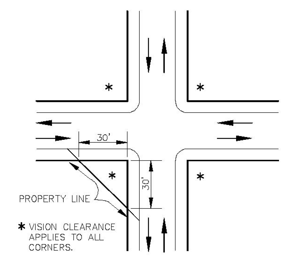
Uncontrolled intersections. At uncontrolled intersections, the vision clearance area shall have 30-foot legs along each street (see Figure 805-1).
FIGURE 805-1. UNCONTROLLED INTERSECTIONS
(2)
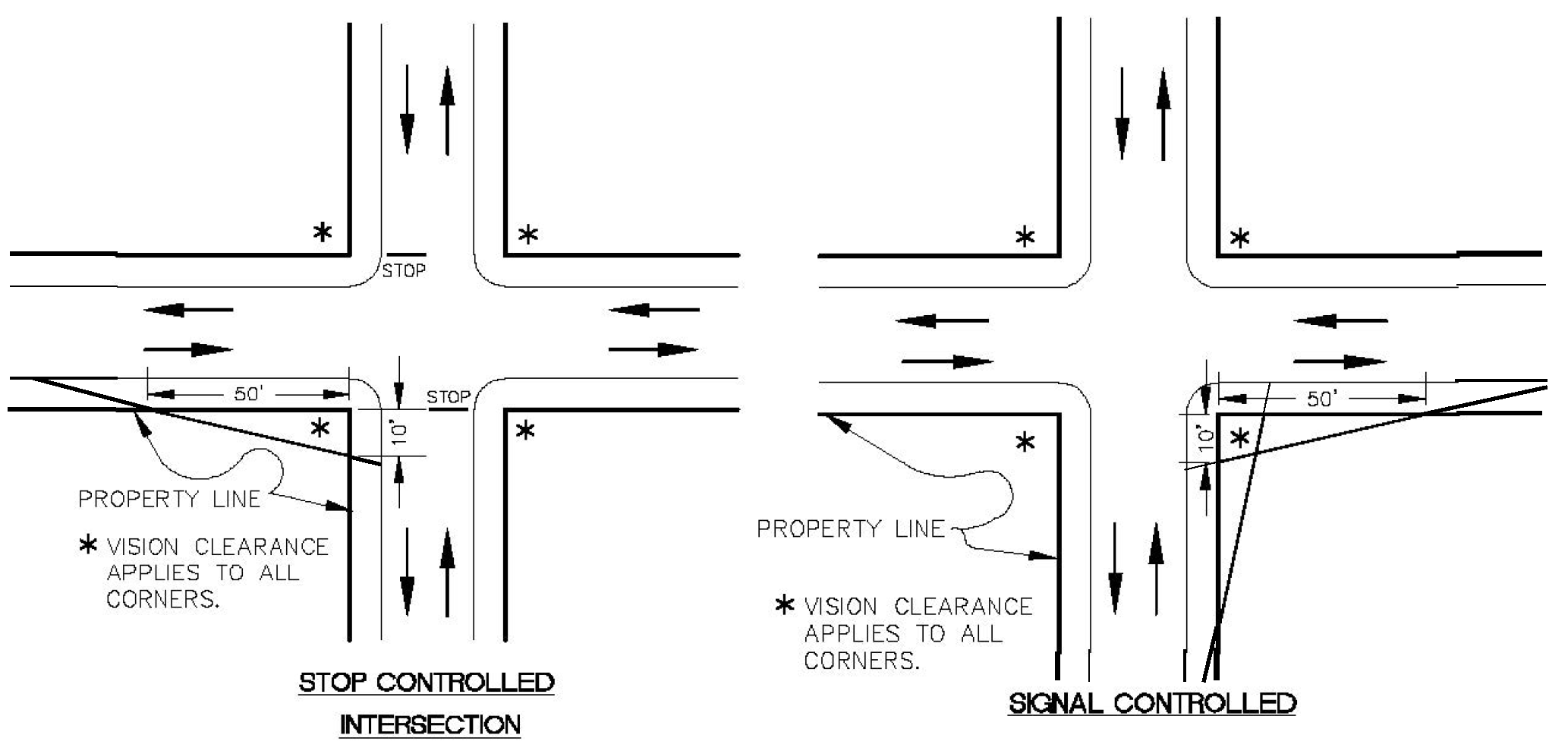
Controlled intersections. At controlled intersections, the vision clearance area shall have a ten-foot leg along the controlled street and a 50-foot leg along the uncontrolled street (see Figure 805-2).
FIGURE 805-2. CONTROLLED INTERSECTIONS
(3)
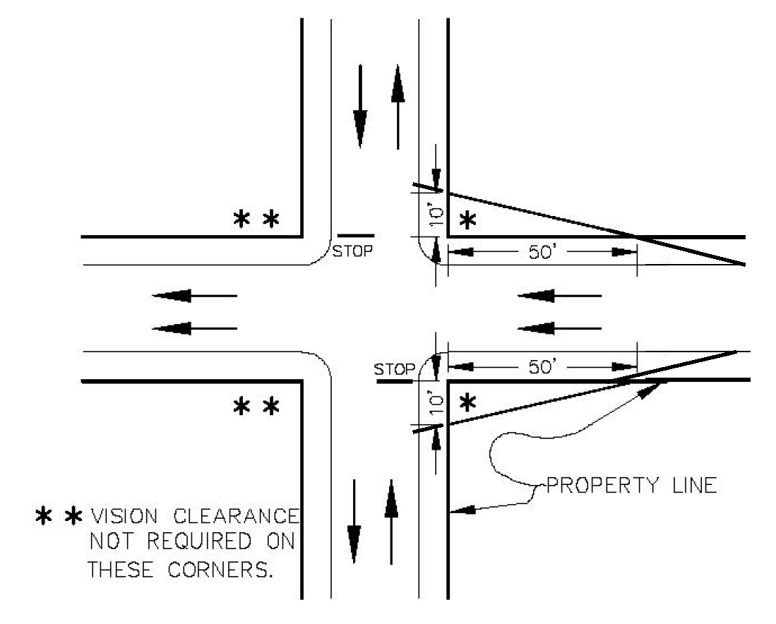
One-way streets. Notwithstanding subsections (a)(1) and (2) of this section, at an uncontrolled or controlled intersection of a one-way street, no vision clearance area is required on the corners of the intersection located downstream from the flow of traffic (see Figure 805-3).
FIGURE 805-3. ONE-WAY STREETS
(b)
Intersections with driveways, flag lot accessways, and alleys. Vision clearance areas at intersections of streets and driveways, streets and flag lot accessways, streets and alleys, and alleys and driveways shall comply with the following:
(1)
Driveways.
(A)
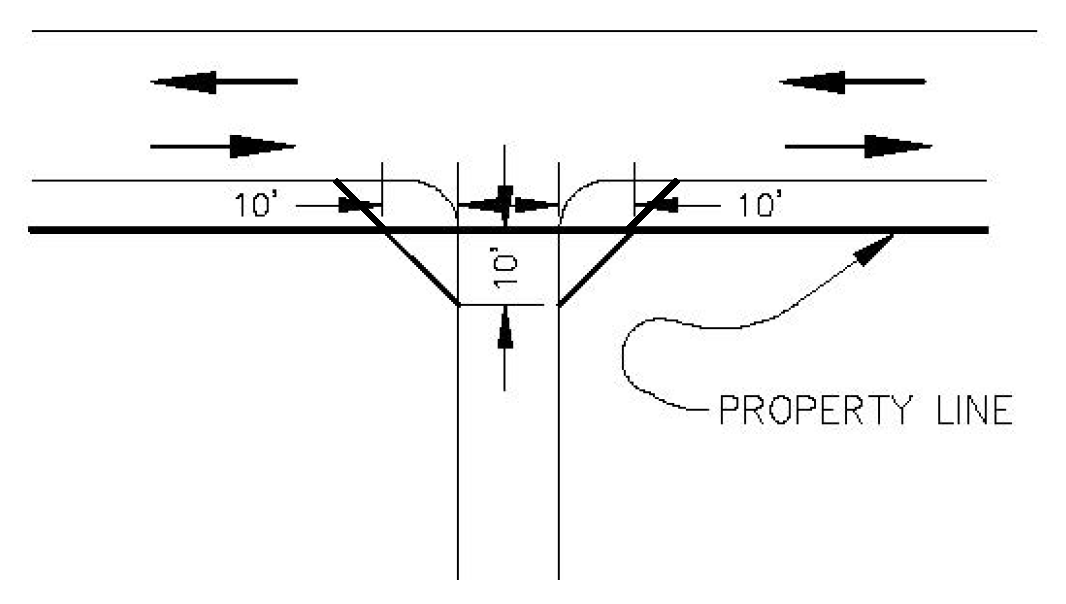
Driveways serving single family and two family uses. Driveways serving single family and two family uses shall have a vision clearance area on each side of the driveway. The vision clearance area shall have ten-foot legs along each side of the driveway, and ten-foot legs along the intersecting street or alley (see Figure 805-4).
FIGURE 805-4. DRIVEWAYS SERVING SINGLE FAMILY AND TWO FAMILY USES
(B)
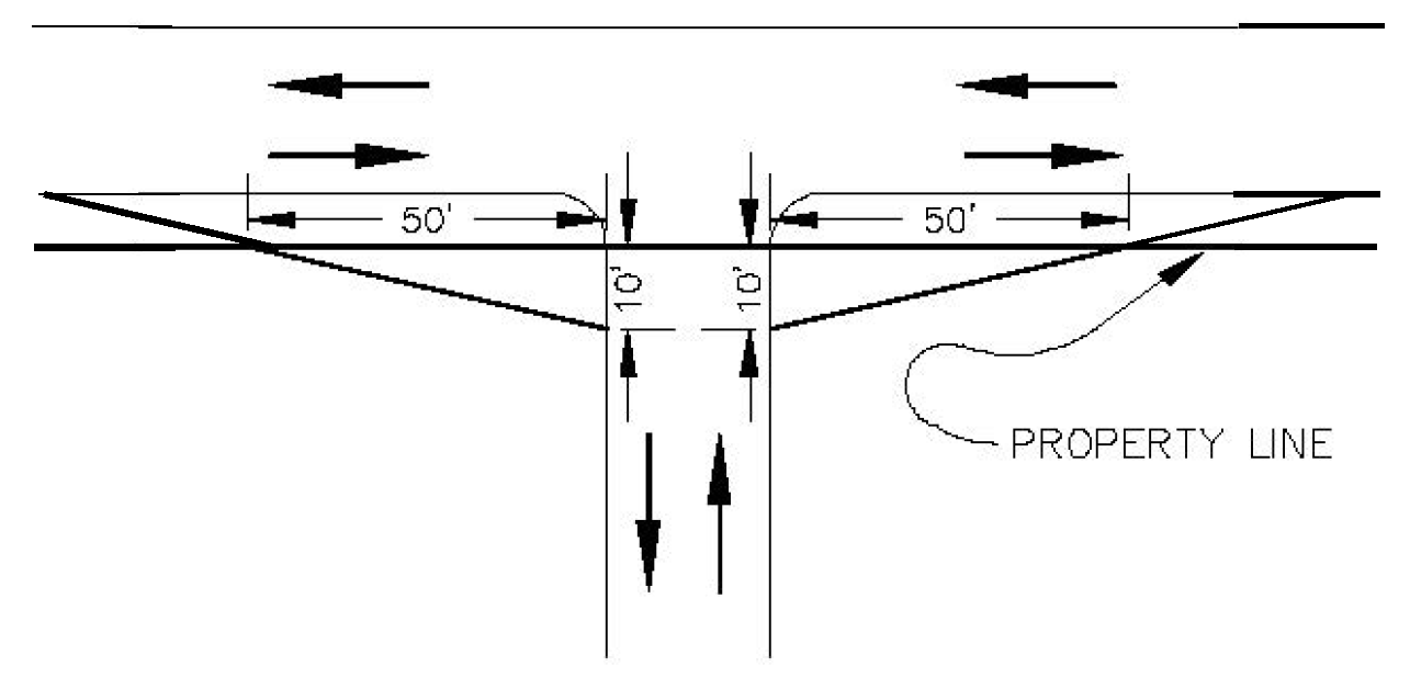
Driveways serving uses other than single family and two family. Driveways serving uses other than single family and two family shall have a vision clearance area on each side of the driveway. The vision clearance area shall have ten-foot legs along the driveway and 50-foot legs along the intersecting street or alley (see Figure 805-5).
FIGURE 805-5. DRIVEWAYS SERVING USES OTHER THAN SINGLE FAMILY AND TWO FAMILY
(2)
Flag lot accessways.
(A)
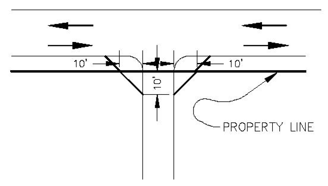
Flag lot accessways serving single family and two family uses. Flag lot accessways serving single family and two family uses shall have a vision clearance area on each side of the flag lot accessway. The vision clearance area shall have ten-foot legs along each side of the flag lot accessway, and ten-foot legs along the intersecting street (see Figure 805-6).
FIGURE 805-6. FLAG LOT ACCESSWAYS SERVING SINGLE FAMILY AND TWO FAMILY USES
(B)
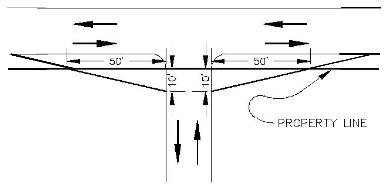
Flag lot accessways serving uses other than single family and two family. Flag lot accessways serving uses other than single family and two family shall have a vision clearance area on each side of the flag lot accessway. The vision clearance area shall have ten-foot legs along the flag lot accessway and 50-foot legs along the intersecting street (see Figure 805-7).
FIGURE 805-7. FLAG LOT ACCESSWAYS SERVING USES OTHER THAN SINGLE FAMILY AND TWO FAMILY
(3)
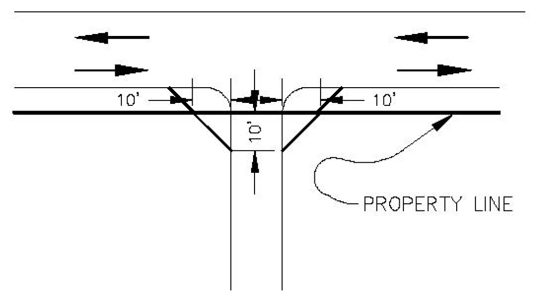
Alleys. Alleys shall have a vision clearance area on each side of the alley. The vision clearance area shall have ten-foot legs along the alley and ten-foot legs along the intersecting street (see Figure 805-8).
FIGURE 805-8. ALLEYS
(4)
Measurement. The legs of a vision clearance area shall be measured along the right-of-way line and along the intersecting driveway, flag lot accessway, or alley.
(Prior Code, § 805.005; Ord. No. 31-13)
Sec. 805.010. - Obstructions to vision prohibited.
Except as otherwise provided in this section, vision clearance areas shall be kept free of temporary or permanent obstructions to vision from 30 inches above curb level to 8.5 feet above curb level; provided, however, where there is no curb, the height shall be measured from the street shoulder. As used in this section, temporary or permanent obstruction includes any obstruction located in the right-of-way adjacent to the vision clearance area.
(a)
The following obstructions may be placed in a vision clearance area, unless the cumulative impact of the placement results in an obstruction to vision:
(1)
A column or post, so long as the column or post does not create a visual obstruction greater than 12 inches side-to-side.
(2)
Utility poles and posts, poles, or supporting members of street signs, street lights, and traffic control signs or devices installed by, or at the direction of, the Public Works Department or any other public agency having jurisdiction over the installation.
(3)
On-street parking.
(b)
Trees. Trees may be planted within a vision clearance area provided they are a species listed on the parks approved street tree list, and they comply with the following:
(1)
The planting area is sufficient to support the tree when mature.
(2)
The tree will not interfere with overhead utilities.
(3)
The tree is a species that can be trimmed/pruned to provide necessary visibility.
(c)
Nothing in this chapter shall be deemed to waive or alter any requirements relating to setbacks or landscaping in the UDC. In the event of a conflict between the standards of this chapter and another chapter of the UDC, the standards in this chapter shall control.
(Prior Code, § 805.010; Ord. No. 31-13)
Sec. 805.015. - Alternative standards.
Alternative vision clearance standards that satisfy the purpose of this chapter, and that are consistent with recognized traffic engineering standards, may be approved where a vision clearance area conforming to the standards of this chapter cannot be provided because of the physical characteristics of the property or street, including, but not limited to, grade embankments, walls, buildings, structures, or irregular lot shape, or where the property has historic neighborhood characteristics, including, but not limited to, established plantings or mature trees, or buildings or structures constructed before 1950. Alternative vision clearance standards shall be approved through a Class 2 Adjustment under SRC chapter 250.
(Prior Code, § 805.015; Ord. No. 31-13)