
Taylor City Zoning Code
ARTICLE 19
- SITE PLAN REVIEW6
State Law reference— Submission and approval of site plan, MCL 125.3501.
Sec. 19.01.- Intent.
(a)
Site plan review is required to provide the planning commission with the opportunity to review the proposed use of a site in relation to surrounding uses, planned future development, accessibility, pedestrian and vehicular circulation, street traffic, spatial relationships, off-street parking, public utilities, general drainage, environmental characteristics and other site elements which may affect the public health, safety, and general welfare, and its relationship and harmony with city ordinances and plans.
(b)
It is further the intent of this article to require the eventual upgrade of existing sites that do not conform with current standards of this article and ensure that the arrangement, location, design and materials within a site are consistent with the character of the city and the goals and design guidelines in the master plan.
(Ord. No. 09-434, § 19.01, 1-20-2009)
Sec. 19.02. - Uses requiring review.
Prior to the establishment of a use, addition to an existing use, or the erection of any building in a zoning district, a site plan shall be submitted and approved by the city in accordance with the procedures of this article, and the development requirements of this and other applicable ordinances.
(a)
Site plan and sketch plan reviews and approvals shall be required for the activities or uses listed in table 19.02.
(b)
Approvals are obtained for the activities listed in table 19.02 below from the planning commission (PC), city council (CC), administrative review committee (ARC), or development services department (DSD) depending upon the nature of the proposed construction or use. Where city council approval is required, it shall be based upon the recommendation of the planning commission.
(c)
All applications for site plan or sketch plan approval shall be reviewed by the ARC, for compliance with the standards of the respective departments. The ARC shall forward site plans to the planning commission, or approve those items specified as ARC approval in table 19.02. The ARC shall consist of representatives of the development services department, fire department, police department, and city engineer.
(d)
Activities and uses that are exempt from site plan/sketch plan approval still require a building permit. All construction or building modification is subject to city building permit requirements of the development services department in accordance with article 25, administration and enforcement. Site preparation work shall not commence until site plan approval has been received and the required permit has been issued by the development services department.
(e)
Procedures for approval of PUDs and condominiums are outlined in article 22, planned unit development (PUD), and article 23, condominiums.
TABLE 19.02. PLAN REVIEW REQUIREMENTS
PC = Planning commission
CC = City council
DSD = Development services department
ARC = Administrative review committee
(Ord. No. 09-434, § 19.02, 1-20-2009)
Sec. 19.03. - Site plan and sketch plan review procedures.
Site plans and sketch plans must be submitted in accordance with the following procedures and requirements:
(a)
Submittal. The application shall be submitted by the owner of an interest in the land for which site plan approval is sought, or the designated agent of the owner, or with a statement signed by the owner granting permission from the property owner for the application. The application shall include the following:
(1)
A complete application form, with original signatures.
(2)
Proof of ownership.
(3)
A written use statement.
(4)
The required fee, as established by the city council.
(5)
Copies of transmittal letters/documentation that the applicant has submitted a copy of the site plan to the Wayne County Department of Public Services (WCDPS), for purposes of conceptual review of proposed utilities and street improvements, approved permits are not required until engineering review.
(6)
A complete site plan that includes the information required by section 19.04, submittal requirements.
(b)
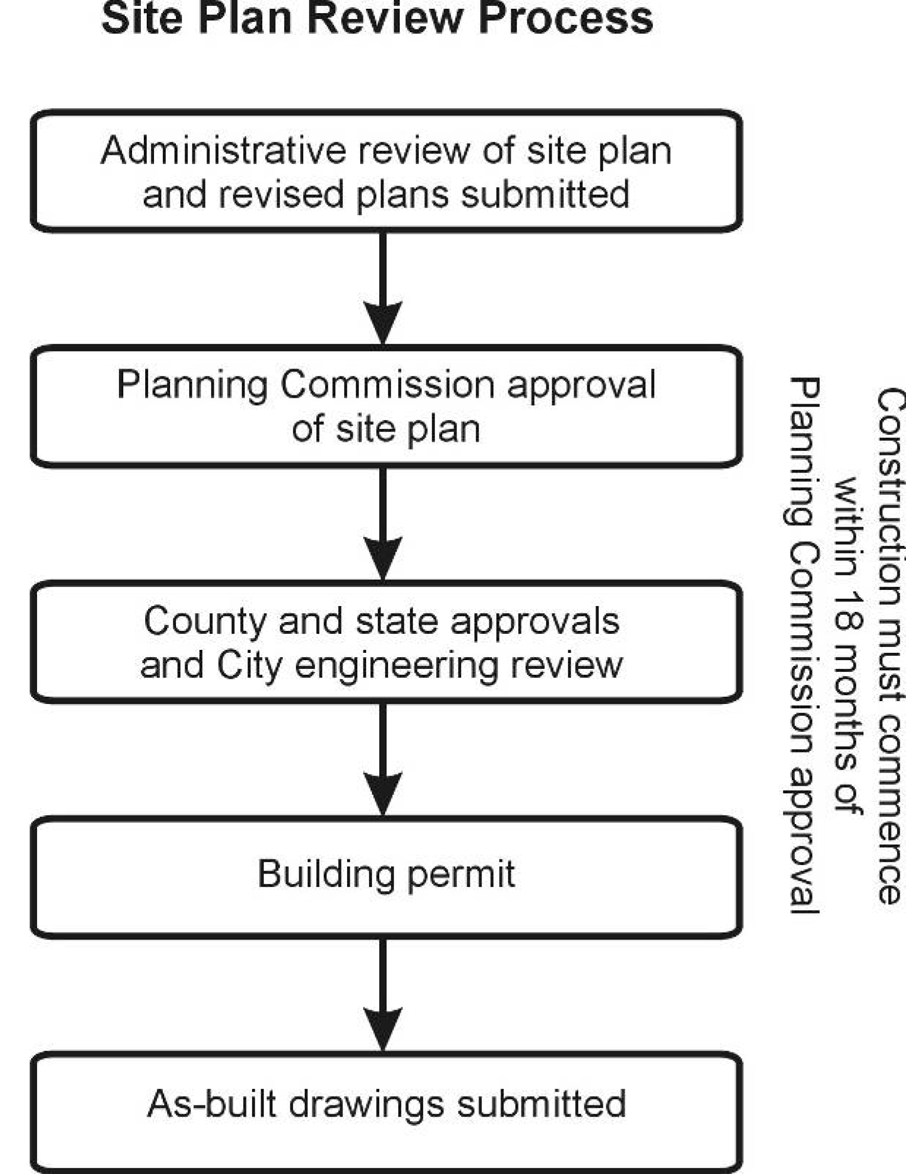
Administrative review.
(1)
Technical reviews. The development services department shall forward the application and site plan/sketch plan to the ARC, consisting of city consultants and departments for technical review.
(2)
Revised plan. Following the ARC review, the applicant shall revise the site plan as necessary and provide revised plans with all of the changes highlighted on the plans and a letter describing all changes for follow-up review. Revised plans must be submitted within 18 months of the initial submittal or the application shall expire and any resubmittal after this date shall require a new site plan application, and review fee.
a.
ARC approval of sketch plans. For sketch plans and other types of approvals that are approved by ARC under table 19.02, the plans shall be approved by ARC once they are found to be in compliance with the requirements of the zoning ordinance and other applicable ordinances. Plans shall then be recorded in accordance with subsection (d) below and be subject to the requirements of subsections (e) through (j) below.
b.
Site plans for planning commission review. For site plans that require planning commission approval, once the plans are in compliance with the requirements of the zoning ordinance and other applicable ordinances, the plans will be forwarded to the planning commission for consideration under subsection (c) below.
(c)
Planning commission review.
(1)
Application and review. Following ARC review, site plans requiring planning commission approval shall be placed on the agenda of the planning commission. The planning commission shall review the application, together with the reports and recommendations from the development services department and other reviewing departments and agencies, as appropriate.
(2)
Planning commission action. The planning commission shall make a determination based on the requirements, and standards of this ordinance and development services department review letter to approve, approve with conditions, postpone a decision, or deny approval of the plan. If approved, any conditions shall be made part of the motion to approve and documented in the planning commission's minutes and development services department written recommendations, a copy of which shall be provided to the applicant.
(d)
Recording of site plan review action. The site plan shall be revised to reflect any conditions of approval and submitted to the development services department. Copies of the approved site plan will be filed with the development services department, including digital files of the approved plan.
(e)
Electronic drawings. Digital files of the approved plans shall be submitted to the development services department. The files shall be compatible with the city's geographic information system software (ArcGIS). Acceptable data formats are ESRI geobase (desired), DXF, or DWG. Digital files shall contain information which references either government corners or existing public right-of-way intersections in distance and direction from the project area. All digital files will be created at a 1:1 scale. Feature or element information within the digital files shall be isolated by both feature groups (files) and layers/levels to meet the city's level specification. Any other information provided within the digital files shall be layer isolated from data included in the city's specification and shall include a written description of both the layer name and the information contained on the layer. Digital information provided to the city shall be delivered in a format compatible with the Microsoft Windows operating system. Acceptable delivery media shall be RW-CD, or zip disk.
(f)
Other agency approvals. The applicant shall obtain all other necessary agency permits from the with other appropriate agency review standards, including, but not limited to, the Michigan Department Natural Resources and Environment (MDNRE), Michigan Department of Transportation (MDOT) and other federal, state and county agencies, as applicable. Copies of applications for all applicable outside agencies shall accompany submission of the application and site plan to the city and approvals shall be obtained prior to the issuance of building permits, and before any substantial development activity takes place.
(g)
Engineering review. Following planning commission approval of a site plan, the city engineer shall make a full review of the engineering plans. A building permit shall not be issued without the approval of the city engineer.
(h)
Building permit. An application for a building permit may be submitted following final approval of the site plan, or sketch plan and engineering plans. The applicant is responsible for obtaining all other applicable city, county, or state permits before a building permit is received.
(i)
As-built drawings. Digital files as-built drawings shall be submitted to the city meeting the format requirements noted in subsection (e) above.
(j)
Property maintenance. The owner of a property shall be responsible for maintaining the property on a continuing basis as required by the approved site plan until the property is razed, until new zoning regulations supersede the regulations upon which site approval was based, or until a new site plan approval is sought. Any physical changes to the site shall require approval of the city under the requirements of this ordinance. This maintenance requirement includes healthy landscaping, walls, fences, pavement, pavement markings, signs, building exterior, drainage facilities and all other elements of a site. Any property owner who fails to maintain a property in compliance with an approved site plan shall be deemed in violation of this ordinance and a nuisance per se.
(Ord. No. 09-434, § 19.03, 1-20-2009)
Sec. 19.04. - Submittal requirements.
The following data is required to be on the site plan. Applicants should obtain a copy of the site plan checklist utilized by the site plan review committee, as well as review this and any other applicable ordinances. Nineteen folded copies are required for each submittal, resubmittal, and/or revision.
TABLE 19.04. SITE PLAN REQUIREMENTS
(Ord. No. 09-434, § 19.04, 1-20-2009)
Sec. 19.05. - Standards for site plan approval.
Based upon the following standards, the planning commission (or ARC where applicable) may deny, approve, or approve with conditions the site plan:
(a)
Use. The proposed use must be permitted in the zoning district and meet all of the applicable use standards.
(b)
Site design characteristics. All elements of the site plan shall be designed to take into account the site's topography; the size and type of lot; the character of adjoining property; the type and size of buildings; and the traffic operations of adjacent streets. The site shall be developed so as not to impede the normal and orderly development or improvement of surrounding property for uses permitted in this article. The site shall be designed to conform to all provisions of this article.
(c)
Building design. The building design shall relate to the surrounding environment in regard to texture, scale, mass, proportion and color. High standards of construction and quality materials will be incorporated into the new development in accordance with the requirements of section 16.01, building appearance.
(d)
Preservation of significant natural features. The landscape shall be preserved in its natural state, insofar as practicable, by minimizing tree and soil removal, alteration to the natural drainage courses, and the amount of cutting, filling and grading. Insofar as practical, natural features and the site topography, shall be incorporated into the proposed site design.
(e)
Access, driveways and circulation. Safe, convenient, uncongested and well defined vehicular circulation within and to the site shall be provided. All driveways shall meet the design and construction standards of the city and Wayne County. Access to the site shall be designed to minimize conflicts with traffic on adjacent streets, particularly left turns into and from the site. For uses having frontage and/or access on a major street, the number, design, and location of access driveways and other provisions for vehicular circulation shall comply with the provisions of article 17, off-street parking, loading, access and circulation requirements. Cross circulation in the form of share driveways, service drives or parking lot connections shall be provided with adjacent uses where required.
(f)
Emergency vehicle access. All buildings and site circulation shall be arranged to permit emergency vehicle access by practicable means to all buildings and areas of the site. Vehicle circulation shall meet turning radius requirements set by the fire department. Fire lanes shall be designated on the site and posted with signage by the developer/property owner at the developer's/property owner's expense prior to occupancy. Fire hydrants, fire suppression systems, fire detection and fire extinguishers shall be provided as required by the fire department.
(g)
Traffic impact. The expected volume of traffic to be generated by the proposed use shall not adversely affect existing streets and traffic patterns. Street access shall minimize excessive vehicle traffic on local residential streets to reduce the possibility of any adverse effects upon adjacent property.
(h)
Sidewalks, pedestrian and bicycle circulation. Pedestrian circulation shall be as provided in section 16.04, sidewalks.
(i)
Parking. The number and dimensions of off-street parking shall be sufficient to meet the minimum required by article 17, off-street parking, loading, access and circulation requirements.
(j)
Loading and outdoor storage. All loading and unloading areas and outdoor storage areas shall be accessed and screened in accordance with article 17, off-street parking, loading, access and circulation requirements.
(k)
Waste receptacles. Waste receptacles shall be provided, accessed and screened as required in section 16.06, waste receptacles.
(l)
Lighting. Exterior lighting shall be provided and arranged in accordance with section 16.05, lighting.
(m)
Mechanical equipment and utilities. Mechanical equipment and utilities, including roof-, building- and ground-mounted, shall be screened in accordance with the requirements of section 16.07, mechanical equipment.
(n)
Landscaping. Landscaping, landscape buffers and greenbelts shall be provided and designed in accordance with the provisions of section 16.02, landscaping.
(o)
Utilities and stormwater management. Public water and sewer facilities shall be available or shall be provided for by the developer as part of the site development. All utilities and stormwater management facilities shall be reviewed and approved by the water and sewer department and Wayne County. Stormwater management facilities shall be provided on site or at a regional or shared facility as approved by Wayne County.
(p)
Other agency reviews. The applicant has provided documentation of compliance with other appropriate agency review standards, including, but not limited to, the Michigan Department Natural Resources and Environment (MDNRE), Michigan Department of Transportation (MDOT) and other federal, state and county agencies, as applicable.
(q)
Hazardous materials. Sites that include storage of hazardous materials or waste, fuels, salt, or chemicals shall be designed to prevent spills and discharges of polluting materials to the surface of the ground, groundwater or nearby surface water bodies. These areas shall be designed to meet all applicable state and federal regulations and incorporate basic management practices for the handling of hazardous materials. Uses that involve the storage of large quantities of hazardous or combustible materials shall be located and designed to ensure no threat to nearby uses and residents is present.
(r)
Site redevelopment. Redevelopment of existing sites shall conform to the site improvement provisions of this ordinance to the extent deemed practical by the planning commission, or ARC, as applicable. The extent of upgrade to site improvements shall be relative to and proportionate with the extent of redevelopment or expansion in accordance with the nonconforming site requirements of section 24.05, nonconforming sites.
(s)
Other studies. The planning commission shall have the authority to require other studies and materials be submitted to confirm compliance with the standards of this section including, but not limited to, traffic impact studies, market studies, environmental assessments or utility capacity analysis.
(Ord. No. 09-434, § 19.05, 1-20-2009)
Sec. 19.06. - Conditions of site plan approval.
(a)
As part of an approval to any site plan, the planning commission or ARC, as applicable, may impose any additional conditions or limitations as may be necessary to ensure that public services and facilities affected by a proposed land use or activity will be capable of accommodating increased service and facility loads caused by the land use or activity.
(b)
Conditions may also be imposed to protect the natural environment and conserve natural resources and energy; to ensure compatibility with adjacent uses of land; and to promote the use of land in a socially and economically desirable manner. Such conditions shall be considered necessary by the planning commission or ARC, as applicable, to ensure compliance with the review standards, and necessary to meet the intent and purpose of this article.
(c)
The conditions imposed on approval of a site plan run with the property and not with the owner of such property.
(d)
A record of conditions imposed shall be recorded in the minutes attached to the approved site plan and maintained by the city. The conditions shall remain unchanged unless an amendment to the site plan is approved by the planning commission, or ARC, as applicable.
(Ord. No. 09-434, § 19.06, 1-20-2009)
Sec. 19.07. - Validity of approved plans.
(a)
Start of construction. Site plan approval is valid for a period of 18 months from the date of approval. Building permits must be issued and physical construction as set forth below must commence within the 18-month period.
(b)
Extensions. Upon written application prior to expiration, the planning commission, or ARC, as applicable, may authorize an extension of the time limit of the site plan approval for an additional one year. The extension shall be based on evidence from the applicant that the development has a likelihood of commencing construction within the extension period. The planning commission, or ARC, as applicable, may require compliance with any amendments to the zoning ordinance since the site plan was originally approved.
(c)
Expiration of site plan approval. In cases where at least 25 percent of the construction authorized by a site plan approval has not completed within 18 months of site plan approval or granting of an extension, the site plan approval shall automatically become null and void and all rights thereunder shall terminate.
(Ord. No. 09-434, § 19.07, 1-20-2009)
Sec. 19.08. - Amendment to approved plans.
Amendments to the approved site plan may occur only under the following circumstances:
(a)
Minor changes.
(1)
Prior to making any change to an approved site plan/sketch plan the applicant or property owner shall notify the development services department of any desired change. The development services department shall review the request and determine whether the requested change is minor or major. The following shall be considered minor changes:
a.
Movement of a building or buildings by no more than five feet, provided all setback, parking, landscaping and other site requirements are still met.
b.
Plantings approved in the landscape plan may be replaced by similar types and sizes of landscaping which provides a similar screening effect on an equal or greater basis.
c.
Trees to be preserved that were damaged or lost during construction may be replaced by trees of a similar species, with two new trees required for each tree replaced.
d.
Improvements to site access or circulation, such as deceleration lanes, boulevards, curbing, pedestrian/bicycle paths, but not the addition of new driveways.
e.
Changes of building materials or design, fencing, screening, or site amenities which will result in a higher quality development, as determined by the development services department.
f.
Changes in interior floor plans which do not alter the character of the use.
g.
Slight modification of sign placement or reduction of size.
h.
Changes required or requested by the city, county, state or federal agency for safety reasons or for compliance with applicable laws that do not alter the basic design, compliance with the standards of approval, nor any specified conditions of the approved site plan.
i.
Situations the development services department deems similar to the above that do not alter the basic design, compliance with the standards of approval, nor any specified conditions of the approved site plan.
(2)
Minor changes to an approved site plan may be approved by the development services department.
(b)
Major changes. All other changes not considered minor shall be considered a major change requiring a new application for site plan review.
(Ord. No. 09-434, § 19.08, 1-20-2009)
Sec. 19.09. - Master development plans for business parks.
In the I-1, I-2 and TRO districts, a master development plan can be submitted to the planning commission for a recommendation to the city council to approve an overall business park plan for an industrial or office development containing more than four building sites or lots. Once the planning commission and city council has approved the master development plan for the overall business park, development of lots or sites within the business park may be approved administratively by ARC, subject to the following:
(a)
The master development plan for the overall business park shall first be approved by the planning commission and city council as follows.
(1)
The master development plan for the overall business park shall comply with the requirements of the city subdivision regulations or the condominium regulations. Subdivision plats and condominium site plans must be approved by the city council based upon the recommendation of the planning commission.
(2)
An existing business park may obtain approval of a master development plan for redevelopment of the business park.
(3)
A business park master development plan may be approved as a plat or condominium based upon the current zoning or may be approved as an industrial PUD under article 22, planned unit developments (PUDs).
(4)
The master development plan must include a development agreement that specifies the general types of uses that will be in the business park and a listing of the persons responsible for the continuous management of the park.
(5)
The master development plan needs to include specifications for developing the individual lots or sites within the business park, including architecture, building materials, landscaping, paved parking, screening of outdoor storage, location of loading docks, setback specifications and signage restrictions.
(6)
All of the streets, sewer, water and stormwater infrastructure must be installed with the development of the overall business park and be in place and inspected by the city prior to development of individual lots or sites in the business park. Sidewalks and common area landscaping shall be installed or a performance guarantee posted with the city to ensure installation with development of each lot. A phased development plan may be approved to install infrastructure and develop lots in phases. All streets within the business park need to be constructed as class A streets and meet city engineering standards.
(7)
There must be a master stormwater management system for the overall business park, such as shared or regional stormwater detention and an organization mechanism to ensure the long term maintenance of the system.
(b)
A site plan submitted for development of a lot or site in an approved business park may be approved administratively by the ARC, if all of the following are met:
(1)
The site plan must comply with all requirements of the business park master development plan and development agreement. A site plan that proposes any deviations must be approved by the planning commission and city council, including any necessary amendments to the development agreement.
(2)
The use must be permitted by-right in the zoning district. Any special land use must be approved by the planning commission in accordance with article 21, special land use review.
(3)
The site plan must comply with all requirements of the zoning ordinance. A site plan that requires a variance from the zoning board of appeals (ZBA) must be approved by the planning commission after the variance is obtained from the ZBA.
(4)
Any discretionary modification provided for in this ordinance, such as reduction in parking requirements, allowance for alternative building materials or modifications to landscaping requirements must be reviewed by the planning commission, except where the modification was specifically approved as part of the development agreement with the business park master development plan.
(Ord. No. 09-434, § 19.09, 1-20-2009)
Sec. 19.10. - Traffic impact studies.
(a)
Applicability and types of studies. The following traffic impact analysis shall be required at the preliminary review stage for any site plan, special land use, condominium project, subdivision plat or rezoning that will generate the traffic noted below. The level of detail required is based on the expected amount of traffic to be generated by the proposed use, based on generally accepted traffic engineering sources as described herein and the Michigan Handbook Evaluating Traffic Impact Studies.
(1)
Traffic impact comparison for rezoning. A comparison of the number of trips expected to be generated during the a.m. peak hour, p.m. peak hour and on a typical weekday for any existing use of the subject site, representative uses permitted under current zoning and representative uses permitted under the requested zoning. For projects where the comparison yields a difference greater than 50 directional trips during a peak hour or 500 trips on a typical weekday, a traffic impact assessment shall be performed.
(2)
Traffic impact assessment. An analysis that evaluates current and future inbound and outbound traffic operations at site access points shall be required for projects expected to generate either 50 through 99 directional trips during a peak hour or 500 through 750 trips during a typical day.
(3)
Traffic impact study. An analysis that evaluates current, background, and future traffic operations at site access points and major signalized or nonsignalized intersections in proximity to the site shall be required for any proposed development which would be expected to generate over 100 directional trips during the peak hour of the traffic generator or the peak hour on the adjacent streets, or over 750 trips in an average day. Intersections to be evaluated in the traffic impact statement shall be established by the city.
(4)
Updates. A traffic impact study or assessment shall also be required for new phases, expansions or changes to a development that requires site plan review, based on the thresholds established above, except where such report was approved (date of site plan approval) within two years of the new site plan submittal date, and a demonstration by the applicant's traffic engineer that traffic volumes have not increased by over two percent annually.
(b)
Required contents. The following information is required for both traffic impact assessments and traffic impact studies unless otherwise specified:
(1)
Existing site conditions. Illustrations and a narrative which describes the characteristics of the site and adjacent street system (planned and existing right-of-way, functional classification, lane configuration, speed limits, any sight distances limitations, locations and potential conflicts with operations at existing access points or intersections within 275 feet of the site's frontage, or greater based upon MDOT access management guidelines, current traffic conflicts, etc.). This description should include surrounding land uses, expected development in the vicinity which could influence future traffic conditions, special site features and a description of any committed street improvements. The study should define and justify the study area selected for analysis.
(2)
Existing traffic conditions. Illustrations, narratives, tables and capacity analysis that reflects existing traffic conditions including:
a.
Street alignment, including any problems with sight distance, number of lanes, lane width and lane configurations;
b.
Posted speed limits for various segments;
c.
Existing traffic control;
d.
Existing signal timing, as applicable;
e.
Existing peak-hour weekday traffic volumes (and daily volumes or peak period counts (7—9 a.m. to 4—6 p.m.) to support the selection of the evaluated peak hour (if applicable) on streets adjacent to the site. For uses with weekend peak characteristics, the city may require new counts be taken on typical weekend days during the anticipated peak hours of the proposed use. All counts shall be collected using accepted practices and shall not be over two years old;
f.
For projects that require a traffic impact study, existing counts and levels of service for intersections in the study area shall be performed; and
g.
For a traffic impact study, crash data shall be provided and analyzed for the most recent three-year period upon which information is available for sites in close proximity to intersections identified as either a "critical crash location" or a "fatality" location, for projects that generate 500 or more peak hour trips. SEMCOG data or UD-10 reports should be used in the analysis. Critical crash locations should be identified using SEMCOG's critical crash thresholds. The city engineer may waive this requirement upon a finding that the crash potential would not be significantly impacted by the proposed project. Crash data shall also be obtained and analyzed if a signal warrant analysis must be performed where existing or projected level of service is D or worse for unsignalized intersections. The signal warrant analysis should contain, at a minimum, warrants 1, 2, 6, 9 and 11.
(3)
Background traffic conditions. Projects that are not expected to be completed and occupied within one year of site plan approval shall provide a separate evaluation of background traffic for the expected completion date of the proposed development. This background traffic shall be based on historic counts to acknowledge general growth trends in the area, plus traffic associated with approved developments either currently under construction or approved (and would be operational before the build-out year of the proposed project), in the project area. The background traffic shall be evaluated based on the existing street system plus programmed improvements where funding has been committed. A level of service analysis shall be preformed for each intersection in the study area. Unfunded mitigation that is not programmed by Wayne County, the city or included in the SEMCOG five-year TIP shall not be provided under the background conditions. Background traffic turning movements shall be illustrated in the report.
(4)
Proposed use or future conditions. For a site plan review, mobile home park, condominium project, a subdivision plat, planned development, or special land use: a description of factors that relate to project trip generation such as the number and types of dwelling units, the gross and usable floor area, the number of employees and shift change factors shall be provided. Intended phasing or future expansion shall be noted. For a rezoning, a description of the potential representative uses which would be allowed, compared to representative uses allowed under current zoning. Representative uses shall include the most intense traffic generation use allowed under current zoning in compliance with all city site development regulations.
(5)
Trip generation forecast. Forecasted trip generation of the proposed use for the a.m. peak hour, the p.m. peak hour and average day shall be provided for the overall project and each phase. The forecasts shall be based on the data and procedures outlined in the most recent edition of trip generation published by the Institute of Transportation Engineers (ITE). The applicant may use other commonly accepted and published sources of data or supplement the standard data with data from at least three similar projects in Michigan.
(6)
Trip reduction. Any trip reduction for pass-by trips, transit, ride-sharing, other modes and internal capture rates shall be based both on ITE findings and documented survey results acceptable to the city.
(7)
Trip distribution. The projected traffic generated shall be distributed (inbound v. outbound, left turn v. right turn) onto the existing street network to project turning movements at site access points, and nearby intersections where required. Projected turning movements shall be illustrated in the report. A description of the application of standard engineering procedures for determining the distribution should be provided such as trip distribution model, market studies or counts at existing driveways.
(8)
Access point level of service. A level of service or capacity analysis is required at the proposed access points using the procedures outlined in the most recent edition of the Highway Capacity Manual published by the transportation research board. The capacity analysis should be provided in the appendix of the report.
(9)
Intersection level of service. Traffic impact studies shall provide capacity analyses for all nearby street intersections identified by the city under the following conditions:
a.
Existing traffic under existing street conditions.
b.
Future project traffic under existing street conditions with programmed street improvements that will be completed before the build-out year of the proposed project.
c.
Future traffic, including project and background, under background street conditions. Background street conditions shall include the existing street system plus programmed improvements where funding has been committed.
(10)
Warrant analysis. A traffic signal warrant analysis based on the procedures outlined in the Michigan Manual of Uniform Traffic Control Devices shall be performed for unsignalized intersections identified with an existing level of service D or worse for existing conditions. The signal warrant analysis should contain, at a minimum, warrants 1, 2, 6, 9 and 11. For un-signalized intersections projected to operate at level of service D or worse under background or future conditions, an assessment using the peak hour (warrant 11) shall be provided. At least two traffic signal warrants should be met to warrant a signal.
(11)
Access design. The report shall include a map and description of the location and design of proposed access (driveways or new street intersections) including:
a.
Sight distance limitations and sketches from field notes.
b.
Dimensions from adjacent driveways and intersections within 275 feet on either side of the main street, or greater based upon MDOT access management guidelines.
c.
Potential for shared access facilities.
d.
Data to demonstrate that the number of driveways proposed is the fewest necessary.
e.
Support that the access points will provide safe and efficient traffic operation and be in accordance with the standards of section 17.05, driveway access management, and the applicable road agency.
f.
Comments shall also be provided on internal circulation design such as the adequacy of queuing (stacking) at site access points and other features that may affect traffic operations and safety.
(11)
Nonmotorized transportation. The report shall include an analysis of nonmotorized facilities, including pedestrian and bicycle. Pedestrian level of service shall consider the presence of sidewalks, width of sidewalks, buffers between sidewalks and motor vehicle travel lanes, presence of barriers within the buffer area, crosswalks and driveway frequency. Bicycle level of service shall consider the presence of bike lanes or paved shoulders, proximity of bicyclists to motorized vehicles, motorized vehicle volume, speed, and percentage of trucks and pavement condition.
(12)
Mitigation. The study shall outline mitigation measures and demonstrate any changes to the level of service achieved by these measures for the proposed future conditions.
a.
Mitigation shall be provided to ensure that all intersections operate at a level of service D or better during the peak hours of the day. The mitigated capacity analysis should be provided in the appendix of the report. Any alternatives or suggested phasing of improvements should be described and illustrated. The mitigation measures may include items such as, but not limited to, street widening, change to street intersection alignment or grades, need for bypass lanes or deceleration tapers/lanes, changes to signalization, relocation change in design, or reduction in number of access points, or a reduction in the proposed density of intensity of use. Sketches should be provided of suggested mitigation. Any mitigation that involves changes to optimize signal timing must demonstrate that such changes will benefit the overall operations and will be acceptable to the applicable road agency. Proposed mitigation measures should be discussed with Wayne County and MDOT, as applicable. The responsibility and timing of street improvements shall be described.
b.
Mitigation shall also include measures to improve nonmotorized safety and level of service. All developments shall include walkable design elements such as sidewalks, design that favors pedestrians over autos within the site, safe and dedicated pedestrian access from the public sidewalk to the building entrance and links to adjacent land uses. This may also include improvements to the pedestrian system that will enhance the level of service for pedestrians using the site, such as improved streetscape along sidewalk, convenient access to transit stops, enhanced crosswalks and filling in gaps in the pathway system. Bike amenities would include upgrades to bike paths along a site's frontage or the provision of bike facilities onsite, such as bike racks.
(c)
Qualifications of preparer. The person responsible for the preparation of the study shall have a degree or specific professional training in the preparation of traffic impact studies. The preparer shall have at least three years of recent experience in the preparation of traffic impact studies, provide evidence of ongoing experience and familiarity with the Highway Capacity Manual and other traffic operation evaluation techniques, be an associate (or higher) member of one or more professional transportation-related organizations, and be either a registered engineer (PE) or a planner with AICP or PTP certification. Any study involving street or traffic signal design work shall be prepared by or under the supervision of a registered engineer (PE) with specific training in traffic engineering.
(d)
Procedures.
(1)
The applicant shall submit a traffic impact questionnaire, on a form provided by the city. In addition to completing the questionnaire, the applicant must include a description of the proposed development, the ITE trip generation land uses, and the anticipated number of directional trips generated during the a.m. and p.m. peak hours of the traffic generator or the a.m. and p.m. peak hours on the adjacent streets, as well as for an average day. The city engineer shall review the traffic impact questionnaire and determine the level of traffic impact analysis required (i.e., traffic impact comparison, traffic impact assessment or traffic impact study) and establish the study intersections based on the proposed development and size.
(2)
Once the applicant has complete and submitted the traffic impact analysis to the city, it is distributed to Wayne County, the city engineer, and MDOT, if appropriate. The study is to be submitted at a minimum of 45 days prior to the planning commission meeting at which the proposed development is to be considered.
(3)
If the city or Wayne County determines there are deficiencies in the traffic impact analysis, a report of such deficiencies shall be provided to the applicant and the applicant shall be required to revise and resubmit the traffic impact analysis. Any traffic impact analyses with noted deficiencies will not be re-reviewed until all elements have been addressed. All partial resubmittals will be rejected.
(4)
The city engineer, Wayne County and other review agencies shall provide the planning commission with comments on the traffic impact analysis prior to any consideration of the proposed development.
(5)
The planning commission, the planning commission shall approve or deny the traffic impact study based upon the recommendation of the city engineer, and Wayne County and compliance with the requirements of this ordinance.
(e)
Waiver of requirements. The requirement for a traffic impact study, or the specific study elements required may be waived or modified by the city. Reasons for the waiver or modification shall be documented. Factors to be considered include:
(1)
Street improvements are programmed to be constructed prior to completion of the proposed development which are expected to mitigate any impacts associated with the proposed project.
(2)
The existing level of service along the street is not expected to drop below D due to the proposed project.
(3)
The existing level of service is not expected to be significantly impacted by the proposed project due to specific conditions at this location.
(4)
A similar traffic study was previously prepared for the site and is still considered applicable.
(Ord. No. 09-434, § 19.10, 1-20-2009)
Sec. 19.11. - Required site development.
(a)
Purpose and intent. The purpose and intent of the section is to provide for minimum site development improvements required for new uses, addition to an existing use, the erection of any building, the re-occupancy of an existing building or a change of use or a change in ownership. The required site improvements are for the purpose of protecting the health, safety, and welfare of the general public.
(b)
New uses, addition to an existing use, erection of any building. In all zoning districts except for single-family detached dwellings in the R-1A through R-1C and mobile home parks in the R-3 district, the following site development standards shall be complied with:
(1)
Site plan review procedures (article 19, site plan review).
(2)
Site development standards (article 16, general site development regulations).
(3)
Required parking and off-street loading requirements (article 17, off-street parking, loading, access and circulation requirements).
(4)
Area, height, density, bulk, and placement regulations of applicable district.
(5)
Accessory building regulations (article 15, accessory buildings and uses).
(6)
Other development regulations and requirements in this ordinance and other applicable ordinances.
(7)
Manufactured home parks in the R-3 district shall be subject to article 5, manufactured home park districts.
(c)
Re-occupancy of an existing building, a change of use, or a change in tenants. In all zoning districts except for single-family detached dwellings in the R-1A through R-1C Single One-Family Districts and mobile home parks in the R-3 District, the following site development standards shall be complied with whenever occupancy permits or re-occupancy permits in section 25.05 permits are required:
(1)
A sketch plan as required in article 19 site plan review shall be provided to the development services department. The development services department will review the sketch plan and shall ensure compliance with the zoning ordinance.
(2)
Site development standards (article 16 general site development regulations).
(3)
Off-street parking space layout standards, construction and maintenance shall be required in accordance with article 17 off-street parking, loading, access and circulation requirements.
(4)
Public sidewalks shall be provided along all public street rights-of-way.
(5)
Compliance with sign requirements (article 18 signs).
(6)
Landscaping shall be required as specified in section 16.02, landscaping. If there is insufficient area on the site to fully comply with section 16.02, landscaping, then compliance shall be to the extent which the existing site characteristics allow.
(7)
The ZBA may permit a reasonable time schedule to be developed between the petitioner and the city in complying with the necessary improvements to the property.
(8)
In Midtown Taylor Districts, compliance with the site design requirements, in accordance with article 7 midtown districts, shall be required.
(9)
In the Taylor-Dearborn Heights Gateway Overlay District, compliance with the site design requirements, in accordance with article 12 TDH Gateway District, shall be required.
(Ord. No. 09-434, § 19.11, 1-20-2009; Ord. No. 23-510, § 1, 5-16-2023)