
Keizer City Zoning Code
1.200
DEFINITIONS
Sec. 1.200.01. - General provisions.
A.
General and specific terms. The definitions contained in this section include those that are applicable to the entire Keizer Development Code (general), and those terms that are applicable to specific sections (specific). Terms used in specific sections are identified as follows:
B.
Interpretation. When there are two definitions for the same word or phrase, then the definition most applicable for the given situation shall apply. If appropriate, specific terms may be applied to general situations. (5/98)
Sec. 1.200.02. - Grammatical interpretation.
Words used in the masculine or feminine include all genders. Words used in the present tense include the future, and the singular includes the plural. The word "shall" is mandatory. Where terms or words are not defined, they shall have their ordinary accepted meanings within the context of their use. The contemporary edition of Webster's Third New International Dictionary of the English Language (principal copyright 1961) shall be considered as providing accepted meanings. (12/19)
Sec. 1.200.03. - Diagrams.
Diagrams are provided for terms or phrases in order to provide an illustrative example. (5/98)
Sec. 1.200.04. - Definitions.
The following words and phrases, when used in this ordinance, shall have the meanings ascribed to them in this section:
Access. The way or means by which pedestrians and vehicles shall have ingress and egress to property. (5/98)
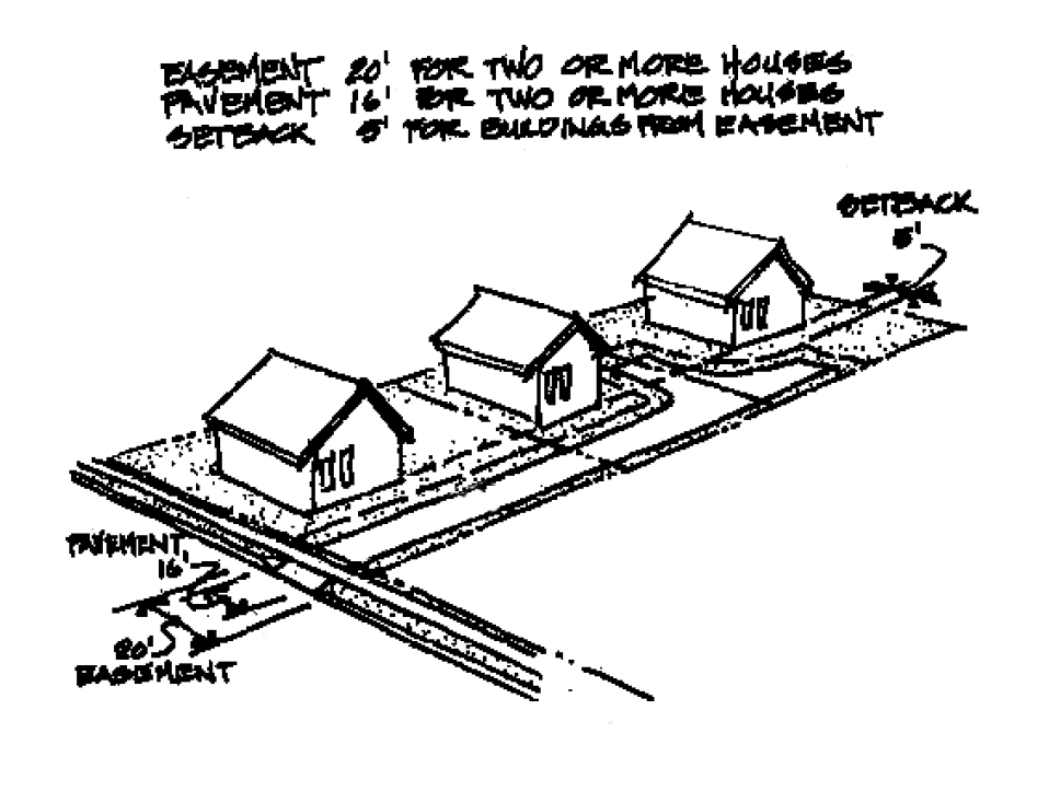
Access easement. A narrow, private, limited use roadway, which provides access to a public street for properties that do not have usable public street frontage. (11/16)
Accessory dwelling. An interior, attached, or detached residential structure that is used in connection with, or that is accessory to, a single-family dwelling. (1/19)
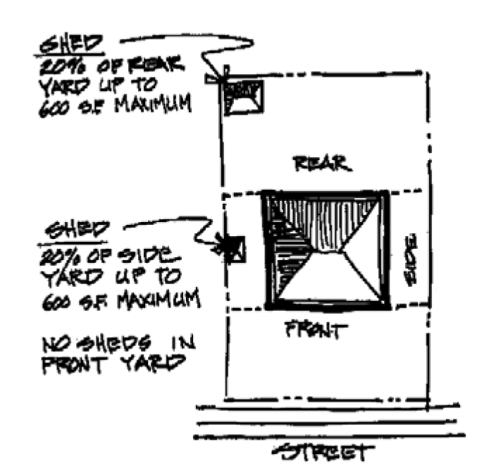
Accessory structure. A detached, subordinate building or portion of a main building, the use of which is incidental to the main building or use of the land, but does not include dwellings or living quarters. (5/98)
Accessory use. A use incidental and subordinate to the main use of the parcel, lot or building. (5/98)
Adjacent. Near or close, but not necessarily abutting or contiguous. For example, a parcel next to or across the street from another parcel shall be considered adjacent. (5/98)
Administrative decision. A decision made by applying the existing standards contained in this ordinance and without a public hearing. (5/98)
Adult entertainment business (Adult). A term intended to cover a broad range of activities characterized by live, closed circuit, digital, or reproduced material which has an emphasis on nudity and/or sexual activity. Adult businesses limit their patrons to persons at least 18 years of age. The term "adult entertainment business" also includes the full range of adult motion picture or video theaters and related businesses, such as adult bookstores, adult theaters, adult massage parlors, adult lotion studios, adult arcades, adult cabarets, adult paraphernalia shops, and other establishments which make up a substantial or significant portion of the establishment's activities or merchandise and constitute a continuing course of conduct of exhibiting specified sexual activities and/or nudity in a manner which appeals to a prurient interest. The term "adult entertainment business" also includes other uses similar to the uses mentioned above, presenting material for patrons to view (live, closed circuit, or reproductions), providing massage or lotion studios for the purpose of fondling or other erotic touching of specified anatomical areas and/or purchase or rent of merchandise which emphasizes nudity and/or specified sexual activity in a manner which appeals to a prurient interest, and limiting entrance to patrons who are over 18 years of age. (5/98)
Alteration (Historic). A change, addition, or modification to the exterior of a building. (5/98)
Alteration or altered (Signs). Any change in the size, shape, method of illumination, position, location, construction, or supporting structure of a sign. A change in sign copy or sign face shall not be considered an alteration. (5/98)
Alteration, structural. Any change in the exterior dimensions of a building or a change which would affect a supporting member of a building, such as a bearing wall, column, beam, or girder. (5/98)
Appeal. A request for a review of a decision authority's action on an application. (5/98)
Appeal (Flood). A request for a review of the interpretation of any provision of this ordinance or a request for a variance. (12/20)
Applicant. The property owner of record or contract purchaser. (5/98)
Approved. Means approved by the community development director, hearings officer, planning commission or city council having the authority to grant such approval. (5/98)
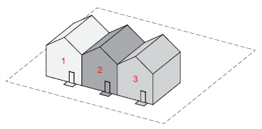
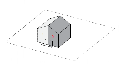
Architectural front. For the purposes of determining building setbacks for residential single and multifamily buildings as permitted in the RL, RM, RH, RC and MU zones the architectural front of a building is opposite the architectural rear. The architectural front is typically the façade with the main point of entry into the building and may include doorways, stairs, windows, and other architectural features typically found on a front of the residential building. It may be oriented towards a street or towards an internal parking lot. (6/07)
Architectural rear. For the purposes of determining building setbacks for residential single and multifamily buildings as permitted in the RL, RM, RH, RC and MU zones the architectural rear of a building is opposite the architectural front, or the façade with the main point of entry into the building. The architectural rear is typically the side of the building that may include such features as porches, patios or other features for use of either individual or multiple units. (6/07)
Architectural side. For the purposes of determining building setbacks for residential single and multifamily buildings as permitted in the RL, RM, RH, RC and MU zones, the architectural side of a building is perpendicular to both the architectural front and rear. The architectural side is typically the façade without any significant architectural features found on either the front or rear of the building. (6/07)
Area. The total area circumscribed by the boundaries of a lot or parcel, except that:
1.
When the legal instrument creating the property shows the boundary extending into a public street right-of-way, then, for purposes of computing, the lot or parcel area shall be the street right-of-way line or, if the right-of-way line cannot be determined, a line running parallel to and 30 feet from the center of the traveled portion of the street. (5/98)
2.
Private access easements, and the access strips to flag lots, shall not be included when calculating the area of a lot or parcel. (5/98)
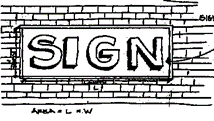
Area (Signs). The area of a sign shall be the entire area within any type of border which encloses the outer limits of any writing, representation, emblem, figure, or character. If the sign is enclosed in a frame or cabinet, the area is based on the inner dimensions of the frame or cabinet surrounding the sign face. When a sign is on a base material and attached without a frame, such as a wood board or plexiglass panel, the dimensions of the base material are to be used. The area of a sign having no such perimeter, border, or base material shall be computed by enclosing the entire area within a parallelogram or a triangle of the smallest size sufficient to cover the entire message of the sign and computing the area of the parallelogram or a triangle. For the purpose of computing the number of signs, all writing included within such a border shall be considered one sign, except for multi-faced signs on a single sign structure, which shall be counted as one sign per structure. The area of multi-faced signs shall be calculated by including only one-half the total area of all sign faces. (5/98)
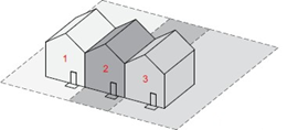
Attached dwellings. Two or more dwelling units on separate properties that share a common wall for a full story that adjoins enclosed habitable space on each side. Attached dwellings shall be joined along a common wall for no less than one story for a distance of at least ten feet. (1/02)
Auto-oriented development. Development that is designed to accommodate customers who use automobiles to travel to the site. Buildings entrances tend to emphasize providing convenient access to parking areas. Other typical characteristics are drive-through facilities, multiple driveways, and a low lot coverage percentages. (7/25)
Automobile, recreational vehicle or trailer sales. A lot used for display, sale, or rental of new or used automobiles, recreational vehicles or trailers and where repair work is limited to minor, incidental repairs. (5/98)
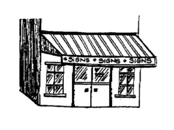
Awning (Signs). A shelter supported entirely from the exterior wall of a building and composed of non-rigid materials, except for the supporting framework. (5/98)
Base flood (Flood). The flood having a one percent chance of being equaled or exceeded in any given year. (12/20)
Base flood elevation (BFE) (Flood). The elevation to which floodwater is anticipated to rise during the base flood. (12/20)
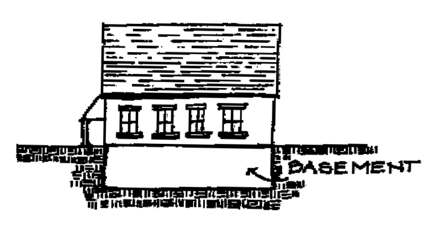
Basement. That habitable portion of a building between floor and ceiling which is all below, or partly below and partly above, grade but so located that for all exterior walls, the average vertical distance from grade to the floor below is equal to or greater than the vertical distance from grade to ceiling. If such portion of a building is not a basement, then it shall be considered a story. (5/98)
Basement (Flood). Any area of the building having its floor subgrade (below ground level) on all sides. (12/20)
Bed and breakfast establishment. A structure designed and occupied as a residence and in which sleeping rooms are provided on a daily or weekly basis with a morning meal provided. (5/98)
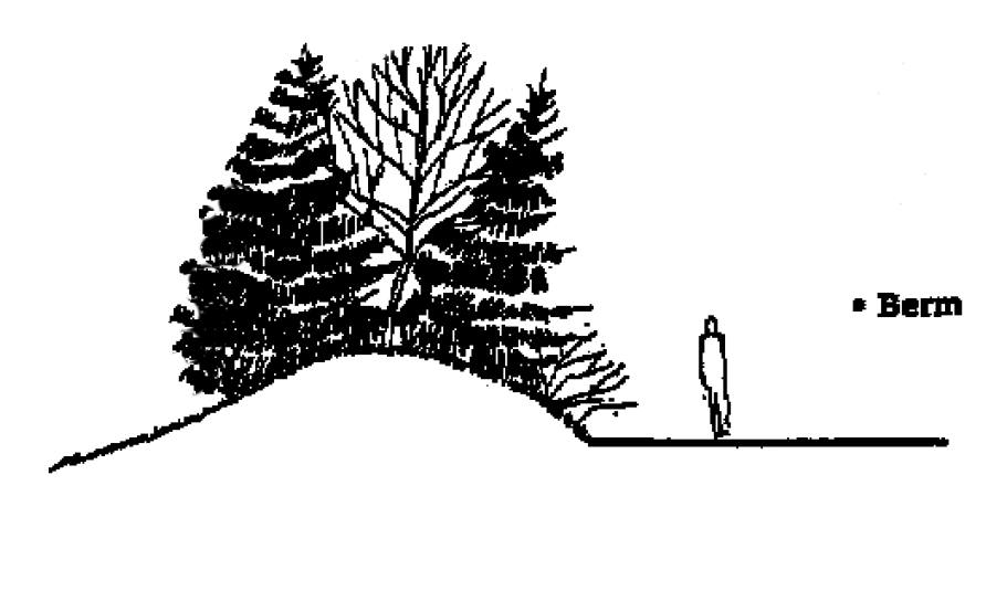
Berm. A linear mound of soil. (5/98)
Bicycle facilities. Improvements which provide for the needs of cyclists, including bicycle paths, bicycle routes and bicycle parking. (5/98)
Biomass facility. An electric generating facility that burns wood, agricultural products, other plant or animal waste or material solid waste as fuel to produce steam which is converted to electricity. This definition also includes a gasification, methane fermentation, or alcohol fuel production facility. (5/98)
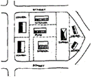
Block. A parcel of land bounded by three or more through streets. (5/98)
Building. A structure having a roof and built for the support, shelter, or enclosure of persons, animals, or property of any kind. Recreational vehicles shall not be considered buildings. (5/98)
Building coverage. The portion of a lot or parcel covered or occupied by buildings or other structures. (5/98)
Building face (Signs). The single wall surface of a building facing a given direction. (5/98)
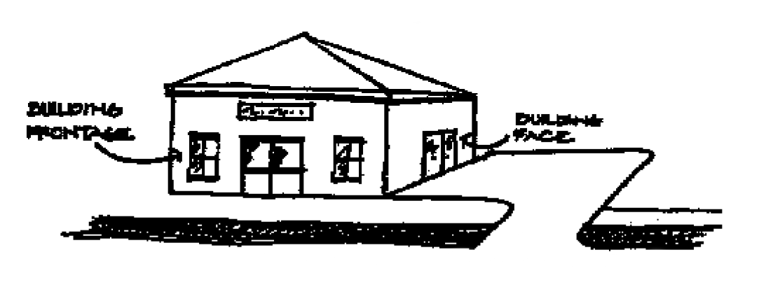
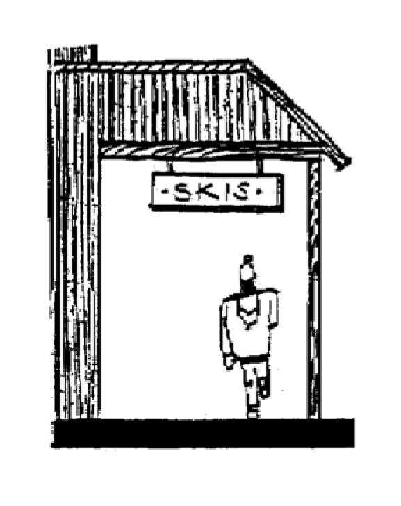
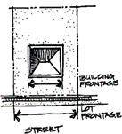
Building frontage (Signs). The portion of a building face most closely in alignment with an adjacent right-of-way or fronting a parking lot. A service station may use the longest side of an overhanging canopy for building frontage. (5/98)
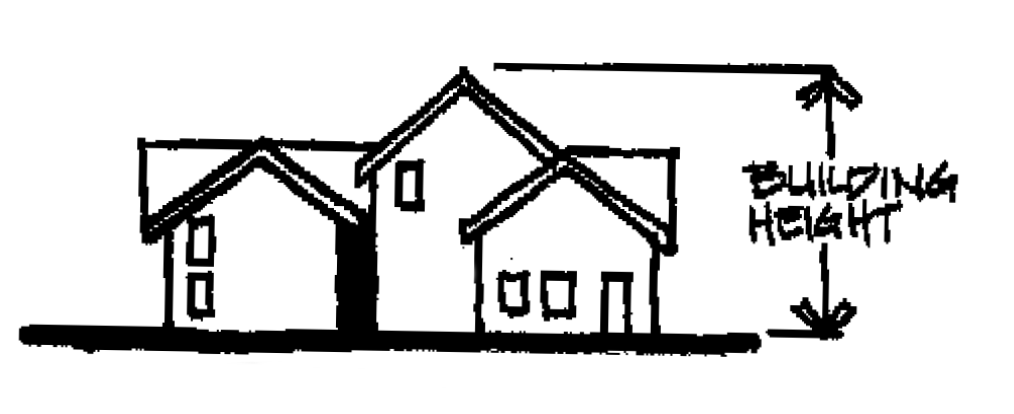
Building height. The vertical distance from the average elevation of the finished grade to the highest point of the structure. By definition, "building height" does not include architectural and building features exempt from height restrictions. (5/98)
Building official. An individual empowered by the city to administer and enforce the Uniform Building Code (UBC). (5/98)
Building plane. The plane of a building wall that extended from the ground to the top of each wall of a structure. Area is determined by multiplying the length of each wall by the height. The plane does not include roof area. (12/18)
Building, main. A building within which is conducted the principal use of the property. (5/98)
Cabana. A stationary structure with two or more walls, used in conjunction with a manufactured home to provide additional living space and meant to be moved with the manufactured home. (5/98)
Canopy sign (Signs). A sign hanging from a canopy or eve, at an angle to the adjacent wall. (5/98)
Carpool. A group of two or more commuters, including the driver, who share the ride to and from work or other destinations. (5/98)
Carport. A structure consisting of a roof and supports for covering a parking space and of which not more than one side shall be enclosed by a wall or storage cabinet. (5/98)
Cemetery. Land used or intended to be used for the burial of the dead and dedicated for cemetery purposes, including a columbarium, crematory, mausoleum, or mortuary, when operated in conjunction with and within the boundary of such cemetery. (5/98)
Change of use. A change from one type of use of a building or land to another type of use. (5/98)
Change of use (Greenway). Making a different use of the land than that which existed on December 6, 1975. It includes a change which requires construction, alterations of the land, water or other areas outside of existing buildings or structures and which substantially alters or affects the land or water. It does not include a change of use of a building or other structure which does not substantially alter or affect the land or water upon which it is situated. The sale of property is not in itself considered to be a change of use. An existing open storage area shall be considered to be the same as a building. Landscaping, construction of driveways, modifications of existing structures, or the construction or placement of such subsidiary structures or facilities as are usual and necessary to the use and enjoyment of existing improvements shall not be considered a change of use. (5/98)
Child foster home. Any home maintained by a person who has under the care of the person in such home any child under the age of 18 years not related to the person by blood or marriage and unattended by the parent or guardian for the purpose of providing such child's care, food and lodging. This use must have a current certificate of approval issued by the State of Oregon. (6/99)
Church. See House of worship. (5/98)
City. The City of Keizer, Oregon. (5/98)
Clinic. A facility operated by a group of physicians, dentists, or other licensed health practitioners on an outpatient basis and not involving overnight housing of patients. (5/98)
Club. An organization, group, or association supported by the members, the purpose of which is to render a service primarily for members and their guests, but shall not include any organization, group, or association the chief activity of which is to render a service customarily carried on as a business for profit. (5/98)
Commission. The Planning Commission of Keizer, Oregon. (5/98)
Common open space. An area, feature, building or other facility within a development intended for the use by the residents of the development. (5/98)
Community (Flood). The city limits of the City of Keizer. (12/20)
Community building. A publicly owned and operated facility used for meetings, recreation, or education. (5/98)
Comprehensive plan. The officially adopted City of Keizer Comprehensive Plan, as amended. (5/98)
Conditional use. A use, which is permitted in a particular zone or elsewhere in this ordinance only after review and approval as a conditional use, including nonconforming conditional uses. (5/98)
Condominium. A building or group of buildings, broken into separate units with each unit being separately owned, while the parcel on which the building(s) is located is held in a separate ownership. Condominiums are subject to the provisions of ORS 94.004 to 94.480 and 94.991. (5/98)
Conforming. In compliance with the regulations of the Code. (5/98)
Construct (Signs). Build, erect, attach, hang, place, suspend, paint in new or different word, affix, or otherwise bring into being. (5/98)
Corner lot. See Lot, corner. (5/98)
Council. The City Council of Keizer, Oregon. (5/98)
Critical facility (Floods). A facility for which even a slight chance of flooding might be too great. Critical facilities include, but are not limited to, schools, nursing homes, hospitals police, fire and emergency response installations, installations which produce, use or store hazardous materials or hazardous waste. (12/20)
Day care facility. An establishment or place, not a part of a public school system, in which are commonly received three or more children, not of common parentage, under the age of 14 years, for a period not exceeding 12 hours per day for the purpose of being given board, care, or training apart from their parents or guardians. (5/98)
Decision. The formal act by which the community development director, hearings officer, planning commission or city council makes its final disposition of a land use action. (5/98)
Demolish (Historic). To raze, destroy, dismantle, deface or in any other manner cause partial or total destruction of a resource. (9/18)
Density. The number of dwellings units per gross acre. (5/98)
Develop. To construct or alter a structure; or, to make alterations or improvements to land for the purpose of enhancing its value. (5/98)
Development or redevelopment. Man-made changes to property, including, but not limited to, buildings or other structures, mining, dredging, filling, grading, paving, excavation, or drilling operations. (1/23)
Development (Floods). Any man-made change to improved or unimproved real estate, including, but not limited to, buildings or other structures, mining, dredging, filling, grading, paving, excavation or drilling operations or storage of equipment or materials. (12/20)
Dormitory. A building, under single management, where group sleeping accommodations are provided for in one room or in a series of closely associated rooms and where meals may be provided. (5/98)
Driveway. A private way used by vehicles and pedestrians to gain access from a public access or right-of-way onto a lot or parcel of land. (5/98)
Drop station. Vehicles or structures of less than a total of 400 square feet maintained on a lot solely to provide shelter for no more than four types of recyclable material (such as paper, tin cans, plastic and bottles) deposited by members of the public and collected at regular intervals for further transfer or processing elsewhere. (5/98)
Duplex. See Dwelling, two-household (duplex). (6/22)
Dwelling, cottage cluster. A grouping of no less than four detached buildings per acre designed exclusively for the occupancy of separate households living independently of each other in each detached building or cottage. Each building shall have a footprint of less than 900 square feet, and the buildings must be oriented around a common courtyard. (6/22)
Dwelling, four-household (quadplex). A building containing four dwelling units designed exclusively for occupancy by four households living independently of each other. (6/22)
Dwelling unit. One or more rooms designed for occupancy by one household providing complete, independent living facilities, including permanent provisions for living, sleeping, eating cooking, and sanitation. (6/22)
Dwelling, middle housing. Refers to housing types required under House Bill 2001 (2019) and associated Administrative Rules. These housing types include duplexes, triplexes, quadplexes, townhouses, and cottage clusters. (6/22)
Dwelling, multi-household (multifamily). A building containing five or more dwelling units designed for occupancy by five or more households living independently of each other. (6/22)
Dwelling, single-household (single-family detached). A detached building containing one dwelling unit designed exclusively for occupancy by one household. (6/22)
Dwelling, three-household (triplex). A building containing three dwelling units designed exclusively for occupancy by three households living independently of each other. (6/22)
Dwelling, townhouse. A building containing one dwelling unit designed exclusively for occupancy by one household that is part of a row of two or more attached dwellings and shares at least one common wall with an adjacent dwelling. (6/22)
Dwelling, two-household (duplex). A detached building containing two dwelling units designed exclusively for occupancy by two households living independently of each other. (6/22)
Easement. A grant of right to use an area of land for a specific purpose. (5/98)
Employees. All persons, including proprietors, performing work on a premises. (5/98)
Encroachment (Flood). Any obstruction in the floodplain which affects flood flows. (5/98)
Family. An individual or two or more persons related by blood, marriage, adoption, or legal guardianship, or a group of not more than five unrelated individuals, living together as a single housekeeping unit. (5/98)
Family day care provider. A day care provider who regularly provides child care in the family living quarters of the home of the provider. (5/98)
Farming. The use of land for purposes defined in ORS chapter 215. (5/98)
Federal Emergency Management Agency (FEMA) (Flood). The federal organization responsible for administering the National Flood Insurance Program. (5/98)
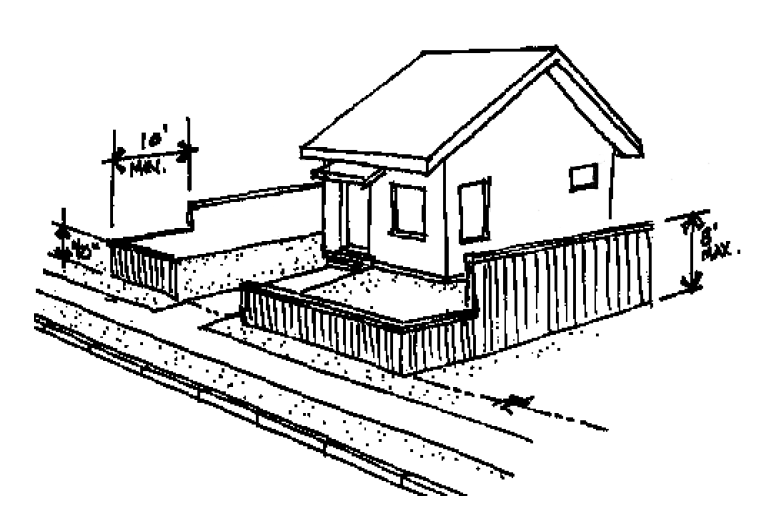
Fence. An unroofed barrier or an unroofed enclosing structure or obstruction constructed of any materials, including, but not limited to, wire, wood, cement, brick, and plastic. (5/98)
Fence, sight-obscuring. A fence arranged or constructed to obstruct vision. (5/98)
Fill (Flood). The placement of any material on the land for the purposes of increasing its elevation in relation to that which exists. Fill material includes, but is not limited to, the following: soil, rock, concrete, bricks, wood stumps, wood, glass, garbage, plastics, metal, etc. (5/98)
Final decision. A decision made in accordance with, and pursuant to, the provisions of this ordinance, or decisions made by the land use board of appeals or the courts, after the applicable appeal periods have expired. (5/98)
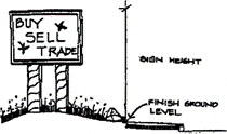
Finish ground level (Signs). The average elevation of the ground (excluding mounds or berms, etc., located only in the immediate area of the sign) adjoining the structure or building upon which the sign is erected, or the curb height of the closest street, whichever is the lowest. (5/98)
Flag lot. See Lot, flag. (5/98)
Flashing sign (Signs). A sign any part of which pulsates or blinks on and off, except time and temperature signs and message signs allowed by conditional use. (5/98)
Flood or flooding (Flood):
(a)
A general and temporary condition of partial or complete inundation of normally dry land areas from: (12/20)
(1)
The overflow of inland or tidal waters. (12/20)
(2)
The unusual and rapid accumulation or runoff of surface waters from any source. (12/20)
(3)
Mudslides (i.e., mudflows) which are proximately caused by flooding as defined in paragraph (a)(2) of this definition and are akin to a river of liquid and flowing mud on the surfaces of normally dry land areas, as when earth is carried by a current of water and deposited along the path of the current. (12/20)
(b)
The collapse or subsidence of land along the shore of a lake or other body of water as a result of erosion or undermining caused by waves or currents of water exceeding anticipated cyclical levels or suddenly caused by an unusually high-water level in a natural body of water, accompanied by a severe storm, or by an unanticipated force of nature, such as flash flood or an abnormal tidal surge, or by some similarly unusual and unforeseeable event which results in flooding as defined in paragraph (a)(1) of this definition. (12/20)
Flood insurance rate map (FIRM) (Flood). The official map of a community on which the Federal Insurance Administrator has delineated both the special hazard areas and the risk premium zones applicable to the community. A FIRM that has been made available digitally is called a digital flood insurance rate map (DFIRM). (12/20)
Flood insurance study (FIS) (Flood). An examination, evaluation and determination of flood hazards and, if appropriate, corresponding water surface elevations, or an examination, evaluation and determination of mudslide (i.e., mudflow) and/or flood-related erosion hazards. (12/20)
Floodplain management (Flood). The operation of an overall program of corrective and preventive measures for reducing flood damage, including, but not limited to, emergency preparedness plans, flood control works, and floodplain management regulations. (12/20)
Floodproofing (Flood). A combination of structural and non-structural additions, changes, or adjustments to structures which reduce or eliminate risk of flood damage to real estate or improved real property, water and sanitary facilities, structures and their contents. (12/20)
Floodway (Flood). The channel of a river or other watercourse and the adjacent land areas that must be reserved in order to discharge the base flood without cumulatively increasing the water surface elevation more than a designated height. Also referred to as "Regulatory Floodway." (12/20)
Floor area. The sum of the gross horizontal areas of the several floors of a building, measured from the exterior faces of the exterior walls or from the centerline of walls separating two buildings, but not including:
1.
Attic space providing headroom of less than seven feet;
2.
Basement, if the floor above is less than six feet above grade;
3.
Uncovered steps or fire escapes;
4.
Private garages, carports, or porches;
5.
Accessory water towers or cooling towers;
6.
Off-street parking or loading spaces. (5/98)
Forest use. The use of land for the production of trees, the processing of forest products, open space, water sheds, wildlife and fisheries habitat, vegetative soil stabilization, air and water quality maintenance, outdoor recreational activities or related support services, wilderness, or livestock grazing. (5/98)
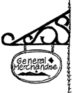
Freestanding sign (Signs). A sign supported by one or more uprights, poles or braces placed in or upon the ground, or a sign supported by any structure primarily for the display and support of the sign. (5/98)

Front lot line. See Lot line, front. (5/98)
Frontage. That portion of a lot or parcel which abuts a public street. (5/98)
Functionally dependent use (Flood). A use which cannot perform its intended purpose unless it is located or carried out in close proximity to water. The term includes only docking facilities, port facilities that are necessary for the loading and unloading of cargo or passengers, and ship building and ship repair facilities, and does not include long-term storage or related manufacturing facilities. (12/20)
Garage. A building, or portion of a building, used for the storage or parking of a vehicle. (5/98)
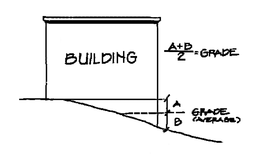
Grade. The average elevation of the finished ground at the centers of all walls of a building, except that if a wall is parallel to and within five feet of a sidewalk, the sidewalk elevation opposite the center of the wall shall constitute the ground elevation. (5/98)
Group living. Characterized by the long-term (i.e., more than 28 days) residential occupancy of a structure by a group of people who do not meet the definition of "household living." The size of the group typically is larger than the average size of a household. Group living structures do not include self-contained units but rather have common facilities for residents, including those for dining, social and recreational and laundry. Group living is differentiated into two subcategories based on whether residents receive personal care, training and/or treatment:
a.
Room and board facilities where no personal care, training and/or treatment is provided include examples such as dormitories, fraternities, sororities, boarding houses, monasteries and convents, residential hotels, lodging houses operated by organizations for members only, and similar uses.
b.
Long-term facilities where some level of care is provided includes examples such as hospice, nursing and personal care facilities, homes for the deaf or blind, and similar uses.
Exceptions include:
(1)
Lodging where tenancy may be arranged for periods less than one month is considered a hotel or motel use and is classified in the retail sales and service category; however, in certain situations, lodging where tenancy may be arranged for periods less than one month may be classified as a community service use such as short-term housing or mass shelters.
(2)
Facilities for people who are under judicial detainment and are under the supervision of sworn officers are included in the detention facilities category. (12/19)
Habitable space. A room or space in a structure for living, sleeping, eating, or cooking. Bathrooms, toilet compartments, closets, halls, storage or utility space, and similar areas are not considered habitable space. (5/98)
Hearings action. Those actions where opportunity for a public hearing of a land use action is provided by this ordinance. (5/98)
Hearings officer. The person(s) so designated by the council to conduct a quasi-judicial public hearing for certain land use actions. (5/98)
Highest adjacent grade (Flood). The highest natural elevation of the ground surface prior to construction next to the proposed walls of a structure. (12/20)
Historic structure. Any structure that is: (9/18)
1.
Listed individually in the National Register of Historic Places (a listing maintained by the Department of Interior) or preliminarily determined by the Secretary of the Interior as meeting the requirements for individual listing on the National Register; (9/18)
2.
Certified or preliminarily determined by the Secretary of the Interior as contributing to the historical significance of a registered historic district or a district preliminarily determined by the Secretary to qualify as a registered historic district; (9/18)
3.
Individually listed on a state inventory of historic places in states with historic preservation programs which have been approved by the Secretary of Interior; or (9/18)
4.
Individually listed on a local inventory of historic places in communities with historic preservation programs that have been certified either: (9/18)
a.
By an approved state program as determined by the Secretary of the Interior; or (9/18)
b.
Directly by the Secretary of the Interior in states without approved programs. (9/18)
Home occupation. A business or professional activity engaged in by a resident of a dwelling unit as a secondary use of the residence and in conformance with the provisions of the ordinance. Such term does not include the lease or rental of a dwelling unit, the rental of guest rooms on the same premises, or the operation of a day care facility. (5/98)
Hotel. Any building in which lodging is provided to guests for compensation and in which no provision is made for cooking in individual rooms. (5/98)
Household living. Characterized by the occupancy of a residential dwelling unit by a household. Tenancy is arranged on a month-to-month basis or for a longer period. Uses where tenancy may be arranged for a shorter period (i.e., less than one month) are not considered residential; they are considered to be a form of transient lodging (retail sales and service and community service use categories). Apartment complexes that have accessory services such as food service, dining rooms, and housekeeping are included as household living, as are single room occupancy housing (SROs) when at least two-thirds of the units are rented on a monthly basis and meals are prepared by the residents.
Examples include living in houses, duplexes, apartments, condominiums, retirement center apartments, manufactured housing, houseboats, other structures with self-contained dwelling units, and SROs depending on the number of units rented on a monthly basis and meal preparation.
Exceptions include:
(1)
Lodging in a dwelling unit or SRO where less than two-thirds of the units are rented on a monthly basis is considered a hotel or motel use and is classified in the retail sales and service category.
(2)
SROs that contain programs which include common dining are classified as group living.
(3)
Guest houses that contain kitchen facilities are prohibited as accessory to household living uses.
(4)
In certain situations, lodging where tenancy may be arranged for periods less than one month may be classified as a community service use, such as short-term housing or mass shelter. (12/19)
House of worship. A church, synagogue, temple, mosque, or other permanently located building primarily used for religious worship. A house of worship may also include accessory buildings for related religious activities and a residence. (5/98)
Incidental sign (Signs). A sign which is normally incidental to the allowed use of the property but can contain any message or content. Such signs can be used for, but are not limited to, nameplate signs, warning or prohibition signs, and directional signs not otherwise allowed. (5/98)
Indirect illumination (Signs). A source of illumination directed toward such sign so that the beam of light falls upon the exterior surface of the sign. (5/98)
Integrated business center (Signs). A group of two or more businesses which are planned or designed as a center, and share a common off-street parking area or access, whether or not the businesses, buildings or land are under common ownership. (5/98)
Intensification (Greenway). Any additions which increase or expand the area or amount of an existing use or the level of activity. Remodeling of the exterior of a structure not excluded below is an intensification when it will substantially alter the appearance of the structure. Maintenance and repair usual and necessary for the continuance of an existing use is not an intensification of use. Reasonable emergency procedures necessary for the safety or the protection of property are not an intensification of use. Residential use of lands within the greenway includes the practices and activities customarily related to the use and enjoyment of one's home. Landscaping, construction of driveways, modification of existing structures, or construction or placement of such subsidiary structures or facilities adjacent to the residence as are usual and necessary to such use and enjoyment shall not be considered an intensification for the purpose of this goal. Seasonal increases in gravel operations shall not be considered an intensification of use. (5/98)
Internal illumination (Signs). A source of illumination from within a sign. (5/98)

Joint use sign (Signs). When two of more businesses combine part or all of their total allowed sign area into freestanding sign for each common frontage of such business. (5/98)

Junk. The term "junk," regardless of value, includes, but is not be limited to, any derelict, neglected, or wrecked motor vehicle or parts thereof, glass, paper, waste tire, waste or discarded material, or any of the following old items: machinery or parts thereof, used fixtures, metal, lumber, or wood. For the purposes of this definition, the following meanings apply:
1.
Derelict vehicle means any used motor vehicle without a valid vehicle license or with an expired license. (5/98)
2.
Neglected vehicle means a motor vehicle that is missing its engine or transmission but has all of its body parts intact, including fenders, hood, trunk, glass, and tires. (5/98)
3.
Fixture means any item that is designed to be used indoors or otherwise protected from the elements. This includes, but is not limited to, upholstered furniture, and heating, plumbing, and electrical fixtures. (5/98)
4.
Waste tire means a tire that is no longer suitable for its original intended purpose because of wear, damage, or defect. (5/98)
5.
Wrecked vehicle means a motor vehicle that is dismantled, or partially dismantled, or having a broken or missing window or windshield, or lacking a wheel or tire. (5/98)
Junkyard. The use of more than 200 square feet of the area of any lot for the storage of salvage materials, including scrap metals or other scrap materials, or for the dismantling or wrecking of automobiles or other vehicles or machinery, whether or not such uses are conducted as a business for profit or otherwise. (5/98)
Kennel. Any lot or premises on which four or more dogs and/or cats over the age of four months are kept for sale, lease, boarding, or training. (5/98)
Land division. Any partition or subdivision of a lot or parcel. (5/98)
Land use action. An amendment to the City of Keizer Comprehensive Plan or this ordinance, or a decision on a zone change, variance, conditional use, partitioning or subdivision, or administrative permits, including appeals from any of the foregoing decisions. Issuance of a building permit is not a land use action. (5/98)
Landscaped. Areas primarily devoted to the planting and preservation of trees, shrubs, lawn and other organic ground cover, together with other natural or artificial supplements such as watercourses, ponds, fountains, decorative lighting, benches, arbors, gazebos, bridges, rock or stone arrangements, pathways sculpture, trellises, and screens. (5/98)
Legislative action. A land use action involving amendments to the comprehensive plan, the text of this ordinance, or an amendment to the comprehensive plan map or zoning map involving more than five separate property ownerships. (5/98)
Letter of map change (LOMC) (Flood). Means an official FEMA determination, by letter, to amend or revise effective flood insurance rate maps and flood insurance studies. The following are categories of LOMC: (12/20)
1.
Conditional letter of map amendment (CLOMA). A CLOMA is FEMA's comment on a proposed structure or group of structures that would, upon construction, be located on existing natural ground above the base (one percent annual chance) flood elevation on a portion of a legally defined parcel of land that is partially inundated by the base flood. (12/20)
2.
Conditional letter of map revision (CLOMR). A CLOMR is FEMA's comment on a proposed project that would, upon construction, affect the hydrologic or hydraulic characteristics of a flooding source and thus result in the modification of the existing regulatory floodway, the effective base flood elevations, or the special flood hazard area. (12/20)
3.
Conditional letter of map revision based on fill (CLOMR-F). A CLOMR-F is FEMA's comment on a proposed project that would, upon construction, result in a modification of the special flood hazard area through the placement of fill outside the existing regulatory floodway. (12/20)
4.
Letter of map amendment (LOMA). An official amendment, by letter, to the flood insurance rate maps (FIRMs) based on technical data showing that an existing structure, parcel of land or portion of a parcel of land that is naturally high ground, (i.e., has not been elevated by fill) above the base flood, that was inadvertently included in the special flood hazard area. (12/20)
5.
Letter of map revision (LOMR). A LOMR is FEMA's modification to an effective flood insurance rate map (FIRM) or flood boundary and floodway map (FBFM), or both. LOMRs are generally based on the implementation of physical measures that affect the hydrologic or hydraulic characteristics of a flooding source and thus result in the modification of the existing regulatory floodway, the effective base flood elevations, or the SFHA. The LMOR officially revises the FIRM or FBFM, and sometimes the flood insurance study (FIS) report, and, when appropriate, includes a description of the modifications. The LOMR is generally accompanied by an annotated copy of the affected portions of the FIRM, FBFM, or FIS report. (12/20)
6.
Letter of map revision based on Fill (LOMR-F). A LOMR-F is FEMA's modification of the special flood hazard area shown on the flood insurance rate map (FIRM) based on the placement of fill outside the existing regulatory floodway. (12/20)
7.
PMR. A PMR is FEMA's physical revision and republication of an effective flood insurance rate map (FIRM) or flood insurance study (FIS) report. PMRs are generally based on physical measures that affect the hydrologic or hydraulic characteristics of a flooding source and thus result in the modification of the existing regulatory floodway, the effective base flood elevations, or the special flood hazard area. (12/20)
Livestock. Domestic animals of types customarily raised or kept on farms for profit or food. (5/98)
Loading space. An off-street space or berth on the same lot with a building, or group of buildings, used for the parking of a vehicle while loading or unloading merchandise, materials or passengers. "Loading space" excludes fire lanes, as they are not considered useable space for loading and unloading. (5/98)
Lot. A unit of land created by a subdivision as defined in ORS 92.010 in compliance with all applicable zoning, subdivision ordinances; or created by deed or land sales contract if there were no applicable zoning, subdivision or partitioning ordinances, exclusive of units of land created solely to establish a separate tax account. Such lots may consist of a:
1.
Single lot of record;
2.
Portion of a lot of record; or
3.
Combination of complete lots of record and portions of lots of record. (5/98)
Lot area. The total area of a lot, measured in a horizontal plane within the lot boundary lines, and exclusive of public and private roads and easements of access to other property. For flag-shaped lots, the access strip shall not be included in lot area for the purposes of minimum lot area requirements of this ordinance. (5/98)
Lot coverage. Area covered by buildings and by roofed but unenclosed structures, whether or not attached to buildings. Covered structures less than five feet in height and having less than 20 square feet of gross floor area shall not be included in calculating lot coverage. (12/19)
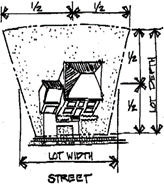
Lot depth. The horizontal distance measured from the midpoint of the front lot line to the midpoint of the rear lot line. (5/98)
Lot of record. A lawfully created lot or parcel established by plat, deed, or contract as duly recorded in Marion County property records. (5/98)
Lot width. The average horizontal distance between the side lot lines, ordinarily measured parallel to the front lot line. (5/98)
Lot, corner. A lot abutting on two intersecting streets, other than an alley or private access easement, where the angle of intersecting streets is no greater than 135 degrees. (5/98)
Lot, flag. A lot or parcel of land with access by a relatively narrow strip of land between the major portion of the parcel and the point of public access to the parcel, all of which is in the same ownership. (5/98)
Lot, frontage. The distance between the two side lot lines measured at the minimum front setback line, parallel to the street line. (5/98)
Lot, interior. A lot other than a corner lot. (5/98)
Lot, through. An interior lot having frontage on two streets. Lots having their access off a private access easement or adjacent to a private access easement shall not be construed as qualifying as through lots. (6/07)
Lot line, front. A lot line abutting a public street, private street, or access easement. In the case of a corner lot, through lot or a lot where vehicular access is provided off an alley and there is no frontage on a public or private street, the front line is based on the structure's orientation and at least two of the following factors:
a.
Location of the front door;
b.
Location of the driveway (when accessed off a public or access easement); and/or
c.
Legal street address.
For flag lots and lots with access from an easement, the zoning administrator shall have the authority to designate another line as the front lot line in which case it shall be clearly noted on the final plat. (01/02)
Lot line, rear. A property line which is opposite and most distant from the front lot line. In the case of an irregular, triangular or other shaped lot, a line ten feet in length within the lot, parallel to and at a maximum distance from the front line. (5/98)
Lot line, side. Any property line which is not a front or rear lot line. (5/98)
Lowest floor (Flood). The lowest floor of the lowest enclosed area (including basement). An unfinished or flood resistant enclosure, usable solely for parking of vehicles, building access or storage, in an area other than a basement area, is not considered a building's lowest floor, provided such enclosure is not built so as to render the structure in violation of the applicable non-elevation design requirements of this ordinance. (5/98)
Main entrance. The principle building entrance intended for the use by the general public, employees or residences. A main entrance door may not be a door that is locked during normal business hours. This entrance is designated the address bearing entrance for the purpose of emergency responders. (5/98)
Major public improvement (Historic). The expenditure of public funds or the grant of permission by a public body to undertake change in the physical character of property on a resource site, except for the repair or maintenance of existing public improvements. (9/18)
Manufactured dwelling (Flood). A structure, transportable in one or more sections, which is built on a permanent chassis and is designed for use with or without a permanent foundation when connected to the required utilities. The term "manufactured dwelling" does not include a recreational vehicle and is synonymous with manufactured home. (12/20)
Manufactured dwelling park or subdivision (Flood). A parcel (or contiguous parcels) of land divided into two or more manufactured dwelling lots for rent or sale. (12/20)
Manufactured home. A home, a structure with a Department of Housing and Urban Development label certifying that the structure is constructed in accordance with the National Housing Construction and Safety Standards Act of 1974 (42 U.S.C. 5401 et seq.), as amended August 22, 1981, and constructed after June 15, 1976. (5/98)
Manufactured home park. Any place where four or more manufactured homes are located within 500 feet of one another on property under the same ownership, the primary purpose of which is to rent or lease space to any person, or to offer space free in connection with securing the trade or patronage of such person. A person shall not construct a new manufactured home park or add lots to an existing manufactured home park without approval by the Department of Commerce. "Manufactured home park" does not include a lot or lots located within a subdivision being rented or leased for occupancy by no more than one manufactured home per lot if the subdivision was approved pursuant to this ordinance. (5/98)
Marijuana grow site. A marijuana grow site that is registered by the Oregon Health Authority Under ORS 475.304 or applicable state law at a specific location used by a grower to produce marijuana for medical use by specific qualifying patients. (10/14)
Marijuana processor. A marijuana processor means a person who processes marijuana items in this state and is licensed by the Oregon Liquor Control Commission under applicable state law. (1/16)
Marijuana producer. A marijuana producer means a person who produces marijuana in this state and is licensed by the Oregon Liquor Control Commission under applicable state law. (1/16)
Marijuana retailer. A marijuana retailer is a person who sells marijuana items to a consumer in this state and is licensed by the Oregon Liquor Control Commission under applicable state law. (1/16)
Marijuana wholesaler. A marijuana wholesaler means a person who purchases marijuana items in this state for resale to a person other than a consumer and is licensed by the Oregon Liquor Control Commission under applicable state law. (1/16)
Master plan. A presentation showing the ultimate development lay-out of a parcel or property that is to be developed in successive stages or subdivisions. (5/98)
Mean sea level (Flood). For purposes of the National Flood Insurance Program, the National Geodetic Vertical Datum (NGVD) of 1929 or other datum, to which base flood elevations shown on a community's flood insurance rate map are referenced. (5/98)
Medical marijuana facility or facilities. A medical marijuana facility that is registered by the Oregon Health Authority under ORS 475.300—475.346 or other applicable state law and that sells, distributes, transmits, gives, dispenses or otherwise provides medical marijuana to qualifying patients. In addition, as allowed by state law and applicable regulation only, "early sales" of recreational marijuana is permitted.*
*This amendment sunsets on December 31, 2016, and is of no force or effect after such date. (10/15)
Message sign (Signs). A sign which can change its message electronically and is designed to display various messages, including, but not limited to, signs displaying time and temperature. (5/98)
Middle housing child lot. A unit of land created from the division of a middle housing parent lot through a middle housing land division for the purpose of having a single dwelling unit per newly created lot or parcel. (6/22)
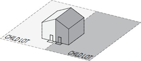
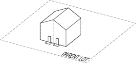
Middle housing land division. A partition or subdivision of a lot or parcel on which the development of middle housing is allowed under state law and the partition or subdivision is processed in accordance with the provisions of ORS ch. 92 and KDC 3.202. The lot or parcel that is the subject of the land division is referred to as the middle housing parent lot; a lot created by the division is referred to as a middle housing child lot. (6/22)
Middle housing parent lot. A lot or parcel that is developed, or proposed to be developed, with middle housing, and which may therefore be further divided through a middle housing land division to create middle housing child lots. (6/22)
Mini-storage warehouse. An area or areas located within an enclosed building or structure used only in connection with the storage of personal property. (5/98)
Mobile food vendor. A non-permanent use that typically is a truck, van, or trailer which has their wheels intact and has been outfitted to prepare and serve food. (9/16)
Modular or prefabricated home. A dwelling unit whose components are assembled and brought to the site and erected. The dwelling unit is intended and designed to be placed upon a permanent foundation and substantial construction is needed before it is complete and ready for permanent occupancy. Modular or prefabricated homes are regulated by the Uniform Building Code (UBC). (5/98)
Motel. A building or group of buildings on the same lot containing rooms designed for lodging, with our without cooking facilities, which are available for rent and in which each lodging unit has a separate entrance from the building exterior. The term includes auto courts, tourist courts, tourist homes, and motor lodges. (5/98)
Multi-faced sign (Signs). A sign which has two or more identical sign faces, contained in a single sign structure. (5/98)

Multifamily dwelling (Signs). A residential structure or complex of structures which include five or more separate dwelling units, whether rented or owned by the occupants. (6/22)
Mural (Signs). An illustration (with or without words or numbers) which is painted or otherwise applied (without projections) to an outside wall of a structure or inside the window of a structure. (5/98)
Natural Register Resource. Buildings, structures, object, sites, or districts listed in the National Register of Historic Places pursuant to the National Historic Preservation Act of 1966 (PL 89-665; 16 U.S.C. 470). (9/18)
Neighborhood activity center. A use, or combination of uses, which is a common destination or focal point for community activities, including primary and secondary schools, neighborhood parks and playgrounds and shopping centers. (5/98)
Neighborhood association. An association recognized by the city council as being a neighborhood association in accordance with the neighborhood association ordinance. (5/98)
New construction. Structures for which construction was initiated on or after the effective date of this ordinance. (5/98)
New construction (Flood). Structure(s) for which the start of construction commenced on or after the effective date of a floodplain management regulation adopted by the City of Keizer and includes any subsequent improvements to such structures. (12/20)
Nonconforming sign (Signs). Any sign which lawfully exists prior to the effective date of this chapter but which, due to the requirements adopted herein, no longer complies with the height, area and placement regulations or other provisions of these regulations. (5/98)
Nonconforming structure or use. A lawfully existing structure or use at the time this ordinance, or any amendment, becomes effective, which does not conform to the requirements of the zone in which it is located. (5/98)
Notification area. An area bounded by a line, parallel to the boundary of a subject lot. As used in this section, "subject lot" includes not only the lot that is the subject of the proceeding for which notice is required but also includes any contiguous lot in which any applicant or owner of the subject lot has either sole, joint, or common ownership, or an option to purchase, in whatever form. In the event that the application does not apply to the entire lot, the boundary of the notification area shall be measured from the lot line, not the boundary of the portion of the lot. (5/98)
Notification list. A certified list prepared by a title company, the Marion County Assessor's Office or the city which includes the names and addresses of all property owners within the notification area as shown in the county assessor's records. (5/98)
Nudity or nude (Adult). Being devoid of an opaque material covering the human genitals, pubic region, buttocks, and female breasts below a point immediately above the top of the areola and where such opaque material does not simulate the organ covered. (5/98)
Nursing home. A home, place or institution which operates and maintains facilities providing convalescent and/or nursing care for period exceeding 24 hours. Convalescent care may include, but is not limited to, the procedures commonly employed in the nursing and caring for the aged and includes rest homes and convalescent homes but does not include a boarding home for the aged, a retirement home, hotel, hospital, or a chiropractic facility licensed under ORS. (5/98)
Official zoning map. The map which indicates the zones in the City of Keizer. (5/98)
Original jurisdiction. The authority and responsibility for rendering the first decision in a land use proceeding. (5/98)
Owner. The owner of record of real property as shown on the latest tax rolls or deed records of the county, or a person who is purchasing a parcel or property under written contract. (5/98)
Owner (Signs). As used in these regulations, "owner" means owner or lessee of the sign. If the owner or lessee of the sign cannot be determined, then "owner" means owner or purchaser of the land on which the sign is placed. (5/98)
Parcel. A unit of land that is created by a partitioning of land. (5/98)
Parking lot or area. An open area, building or structure, other than a street or alley, used for the parking of automobiles and other motor vehicles and available for use by persons patronizing a particular building, establishment or area. (5/98)
Parking space. A designated space in a parking lot or area for the parking of one motor vehicle. (5/98)
Partial harvesting of timber (Greenway). A timber harvest that leaves at least 25 percent of the trees at least six inches DBH standing beyond the vegetative fringe. (5/98)
Partition. To divide an area or tract of land into two or three parcels within a calendar year when such area or tract of land exists as a unit or contiguous units of land under single ownership at the beginning of such year. "Partition" does not include:
1.
Divisions of land resulting from lien foreclosures, divisions of land resulting from contracts for the sale of real property, and divisions of land resulting from the creation of cemetery lots; or
2.
Any adjustment of a lot line by the relocation of a common boundary where an additional parcel is not created and where the existing parcel reduced in size by the adjustment is not reduced below the minimum lot size established by any applicable zoning ordinance; or
3.
A sale or grant by a person to a public agency or public body for state highway, county road, or other right-of-way purposes, provided that such road or right-of-way complies with the applicable comprehensive plan and ORS 215.213 (2)(q) to (s) and 215.283 (2)(p) to (r). (5/98)
Pedestrian circulation system. Pedestrian connection(s) between building entrance(s) of the proposed development and adjacent street(s), the parking area, and the existing or future development on adjacent properties. (5/98)
Pedestrian facilities. Improvements which provide for public pedestrian foot traffic, including sidewalks, walkways, crosswalks and other improvements, such as lighting or benches, which provide safe, convenient and attractive walking conditions. (5/98)
Pedestrian scale lighting. Light standards or placement no greater than 14 feet in height located along walkways. (5/98)
Permit (noun). Any action granting permission to do an act or to engage in activity where such permission is required by this ordinance. (5/98)
Permitted use. Those uses permitted in a zone that are allowed without obtaining a conditional use permit. (5/98)
Person. Every natural person, firm, partnership, association, social or fraternal organization, corporation, estate, trust, receiver, syndicate, branch of government, or any other group or combination acting as a unit. (5/98)
Pet. A domestic animal customarily kept, and cared for, by the occupants of a dwelling for personal pleasure and which are not raised for food, fur, or monetary gain; typically, dogs, cats, birds and other small mammals and reptiles, but not including fowl, herd animals, pigs, goats or horses of any type or breed. (5/98)
Place of public assembly. Structure or place where 50 or more people gather which the public may enter for such purposes as deliberation, education, worship, shopping, entertainment, amusement, awaiting transportation or similar activity. (5/98)
Plan map. An officially adopted map of the city, including urban growth boundary, showing land use designations identified in the comprehensive plan. (5/98)
Planned unit development. A type of development of a site which, as a single project, is based on a design which incorporates all elements of land, structures and uses in conformance with the applicable standards of this ordinance. (5/98)
Planning commission. The Planning Commission of Keizer, Oregon. (5/98)
Plat. The final map which is a diagram, drawing, re-plat or other writing containing all the descriptions, locations, specifications, dedications, provisions, and information concerning a subdivision or partition. (5/98)
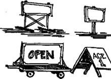
Portable sign (Signs). Any sign that is not originally designed to be permanently affixed to a building, structure, or the ground; a sign originally designed, regardless of its current modification, to be moved from place to place. These signs primarily include, but are not limited to, A-frame or sandwich board signs, signs attached to wood or metal frames and designed to be self-supporting and movable, and also including trailer reader boards. Portable signs are not to be considered temporary signs as defined and used in this chapter. (5/98)
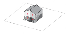
Primary building façade. Primary building façade means the side of a building that faces the street and has a main pedestrian entrance from the street. (01/02)
Professional office. An office occupied by an accountant, architect, attorney-at-law, engineer, surveyor, city or regional planner, insurance agent, real estate broker, landscape architect, or practitioner of the human healing arts, or other professional business similar in type, scale and character. (5/98)
Projecting signs (Signs). A sign the face of which is not parallel to the wall on which it is mounted, projecting more than 12 inches from a structure. (5/98)
Property line adjustment. The realignment of a common boundary between two or more abutting lots or parcels which does not involve the creation of a new lot or parcel. (6/16)
Public facilities and services. Projects, activities, and facilities which are necessary for the public health, safety, and welfare. These may include, but are not limited to, water, gas, sanitary sewer, storm sewer, electricity, telephone and wire communication service, and cable television service lines, mains, pumping stations, reservoirs, poles, underground transmission facilities, substations, and related physical facilities which do not include buildings regularly occupied by employees, parking areas, or vehicle, equipment or material storage areas. (5/98)
Quasi-judicial review. A decision affecting land use within the city which requires the interpretation and/or amendment of existing standards or maps contained in this ordinance. (5/98)
Ramada. A stationary structure having a roof extending over a manufactured home which may also extend over a patio or parking space and is used principally for protection from the elements. (5/98)
Real estate sign (Signs). A sign for the purpose of rent, lease, sale, etc., of real property, building opportunities, or building space. (5/98)
Rear lot line. See Lot line, rear. (5/98)
Recreational vehicle (RV park). A unit, with or without motive power, which is designed for human occupancy and intended to be used for recreational or temporary living purposes. (5/98) "Recreational vehicle" includes:
1.
Camping trailer. A non-motorized vehicle unit mounted on wheels and constructed with sides that can be collapsed when the unit is towed by another vehicle. (5/98)
2.
Motor home. A vehicular unit built on or permanently attached to a motorized vehicle chassis cab or van which is an integral part of the complete vehicle. (5/98)
3.
Travel trailer. A vehicular unit without motive power which has a roof, floor, and sides and is mounted on wheels and designed to be towed by a motorized vehicle, but which is not of such size or weight as to require special highway movement permits. (5/98)
4.
Truck camper. A portable unit which has a roof, floor, and sides and is designed to be loaded onto and unloaded out of the bed of a truck or pickup truck. (5/98)
5.
Boat, licensed or unlicensed, including trailer. (5/98)
6.
All-terrain vehicle (ATV). (5/98)
Recreational vehicle (Flood). A vehicle which is:
1.
Built on a single chassis; (12/20)
2.
400 square feet or less when measured at the largest horizontal projection; (12/20)
3.
Designed to be self-propelled or permanently towable by a light duty truck; and (12/20)
4.
Designed primarily not for use as a permanent dwelling but as temporary living quarters for recreational, camping, travel, or seasonal use. (12/20)
Recreational vehicle park (RV park). Any area operated and maintained for the purposes of providing space for overnight use by recreational vehicles. (5/98)
Recreational vehicle space (RV park). The area under a parked and occupied recreational vehicle. (5/98)
Recycling depot. An area used for the collection, sorting, and temporary storage of non-putrescible waste and discarded materials which are taken elsewhere to be reused or recycled. This definition does not include drop stations. (5/98)
Repair. The reconstruction or renewal of any part of an existing building for the purpose of its maintenance. The word "repair" or "repairs" shall not include structural changes. (5/98)
Residential facility. A facility licensed by or under the authority of the department of human resources under ORS 443.400—443.460 which provides residential care alone or in conjunction with treatment or training or a combination thereof for six to 15 individuals who need not be related. Staff persons required to meet department of human resources licensing requirements shall not be counted in the number of facility residents and need not be related to each other or to and resident of the residential facility. (5/98)
Residential home. A home licensed by or under the authority of the department of human resources under ORS 443.400—443.825 which provides residential care alone or in conjunction with treatment or training or a combination thereof for five or fewer individuals who need not be related. Staff persons required to meet department of human resources licensing requirements shall not be counted in the number of facility residents and need not be related to each other or to any resident of the residential facility. (5/98)
Resource (Historic). A site, object, building, or structure designated by the council under section 2.127.04. (9/18)
Retail trade. The process of selling to the consumer for direct consumption and not for resale. (5/98)
Right-of-way. The full length and width of a public street or way, planned or constructed. (5/98)
Roof sign (Signs). A sign or any portion of which is displayed above the highest point of the roof, whether or not such sign also is a wall sign. (5/98)
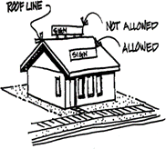
Roofline (Signs). Either the eaves of the roof or the top of the parapet, at the exterior wall. A mansard roof is below the top of a parapet and is considered a wall for sign purposes. (5/98)
Rooming and boarding house. A residential building or portion thereof with guest rooms, providing lodging, or lodging and meals, for three or more persons for compensation. (5/98)
Rotating/revolving sign (Signs). A sign, all or a portion of which, moves in some manner. (5/98)
School, elementary, middle school, or high school. An institution, public or parochial, offering instruction in the several branches of learning and study, in accordance with the rules and regulations of the state department of education. (5/98)
School, trade or commercial. A building where the instruction is given to pupils for a fee, which fee is the principal reason for the existence of the school. (5/98)
Scrap and waste materials establishment. A business that is maintained, operated or used for storing, keeping, buying or selling old or scrap copper; brass, rope, rags, batteries, paper, rubber, or debris; waste or junked, dismantled, wrecked, scrapped, or ruined motor vehicles or motor vehicle parts (except wrecking yards), iron, steel, or other old scrap metal or non-metal materials. "Scrap and waste materials establishment" does not include drop stations, solid waste transfer stations, or recycling depot. (5/98)
Semi-public use. A structure or use intended for a public purpose by a nonprofit organization. (5/98)
Serial additions, alterations or expansions. Two or more additions, alterations or expansions to the existing building gross floor area and/or impervious surface area within a three-year time period. (12/03)
Service station. A site and associated buildings designed for the supplying of motor fuel, oil, lubrication and accessories to motor vehicles, but excluding major repair and overhaul. "Major repair and overhaul," as used in this definition, shall be considered to include such activities at painting, bodywork, steam cleaning, tire recapping, and major engine or transmission overhaul or repair involving the removal of a cylinder head or crankcase. (5/98)
Setback. The distance between a specified lot line and the foundation or exterior wall of a building or structure. (5/98)
Shallow flooding area (Flood). A designated Zone AO, AH, AR/AO or AR/AH on a community's flood insurance rate map (FIRM) with a one percent or greater annual chance of flooding to an average depth of one to three feet where a clearly defined channel does not exist, where the path of flooding is unpredictable, and where velocity flow may be evident. Such flooding is characterized by ponding or sheet flow. (12/20)
Side lot line. See Lot line, side. (5/98)
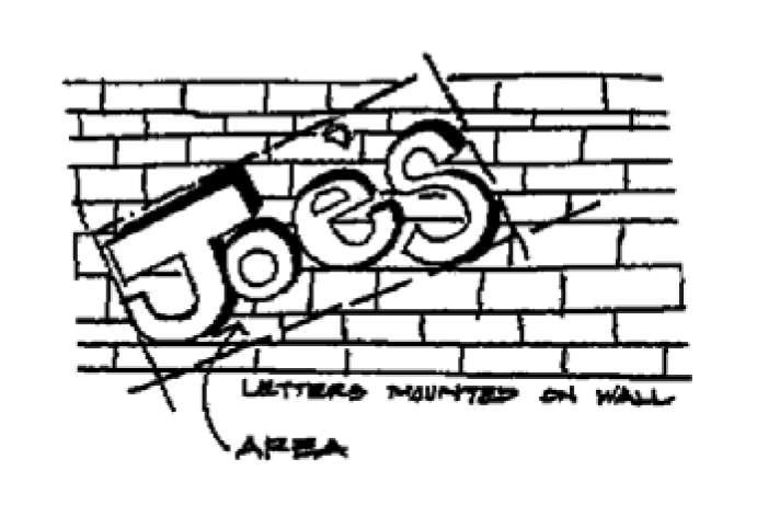
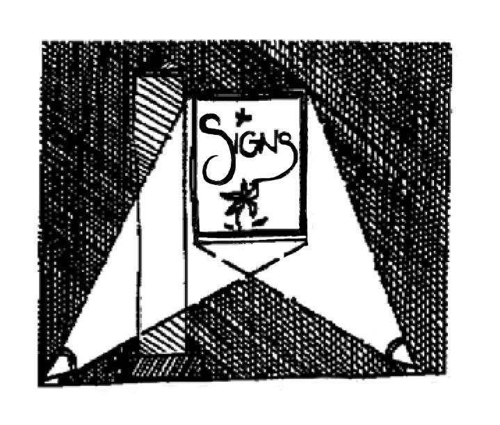
Sign (Signs). Any writing, including letter, word, or numeral; pictorial presentation, including mural, illustration or decoration; emblem, including device, symbol or trademark; flag, including banner or pennant; or any other device, figure or similar thing which is a structure or any part thereof, or is attached to, painted on, or in any other manner represented on a building or structure or device; and is used to announce, direct attention to, or advertise; and is visible from any public right-of-way. (5/98)
Sign face (Signs). Surface of a sign containing the message. The sign face shall be measured as set forth in section 15.10(2). (5/98)
Sign height (Signs). The distance from the finish ground level to the top of the sign or the highest portion of the sign structure or frame, whichever is greater. (5/98)
Sign structure (Signs). The supports, uprights, braces, framework and other structural components of the sign. (5/98)
Site, development, or complex. A group of structures or other development that is functionally or conceptually integrated, regardless of the ownership pattern of the development or underlying land. (5/98)
Solid waste transfer station. A fixed or mobile facility, used as an adjunct to collection vehicle(s), resource recovery facility, disposal site between the collection of the waste/solid waste and disposal site, including, but not limited to, another vehicle, a concrete slab, pit, building, hopper, railroad gondola or barge. The term does not include a self-propelled compactor type solid waste collection vehicle into which scooters, pickups, small packers or other satellite collection vehicles dump collected solid waste for transport to a transfer, disposal, landfill or resource recovery site or facility. (5/98)
Space, manufactured home. An area or lot reserved exclusively for the use of a manufactured home occupant. This definition excludes individual lots within a subdivision. (5/98)
Special flood hazard area (Flood). The land in the floodplain within a community subject to a one percent or greater chance of flooding in any given year. It is shown on the flood insurance rate map (FIRM) as Zone A, AO, AH, A1-30, AE, A99, AR. "Special flood hazard area" is synonymous in meaning and definition with the phrase "area of special flood hazard." (12/20)
Special permitted use. A use which is a permitted use in a particular zone, subject to compliance with the applicable standards of section 2.400. (5/98)
Specified sexual activities (Adult). Real or simulated acts of sexual intercourse, human/animal sexual intercourse, masturbation, sadomasochistic abuse, sodomy or the exhibition of human organs in a simulated state, or the characterization thereof in a printed or visual form, or fondling or other erotic touching of human genitals, pubic region, buttocks, or female breasts. (5/98)
Standard Industrial Classification (SIC). The document so entitled, published in 1987 by the Office Management and Budget, and used in this ordinance to identify land uses. (5/98)
Start of construction. The actual start of construction, repair, reconstruction, placement or other improvement. (5/98)
Start of construction (Flood). Includes substantial improvement and means the date the building permit was issued, provided the actual start of construction, repair, reconstruction, rehabilitation, addition, placement, or other improvement was within 180 days from the date of the permit. "The actual start" means either the first placement of permanent construction of a structure on a site, such as the pouring of slab or footings, the installation of piles, the construction of columns, or any work beyond the stage of excavation; or the placement of a manufactured dwelling on a foundation. "Permanent construction" does not include land preparation, such as clearing, grading, and filling; nor does it include the installation of streets and/or walkways; nor does it include excavation for a basement, footings, piers, or foundations or the erection of temporary forms; nor does it include the installation on the property of accessory buildings, such as garages or sheds not occupied as dwelling units or not part of the main structure. For a substantial improvement, "the actual start of construction" means the first alteration of any wall, ceiling, floor, or other structural part of a building, whether or not that alteration affects the external dimensions of the building. (12/20)
Story. That portion of a building included between the upper surface of any floor and the upper surface of the floor next above, except that the topmost story shall be that portion of a building included between the upper surface of the topmost floor and the ceiling or roof above. Any basement, as defined herein, that is habitable shall be deemed a story for the purpose of administering all fire, life, safety codes, including the Uniform Fire Code. (5/98)
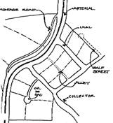
Street. The entire width between the boundary lines of every way of travel which provides for ingress and egress for vehicular and pedestrian traffic and the placement of utilities to one or more lots, parcels, areas, or tracts of land. Streets shall follow the locally adopted street designations. A private way created to provide ingress and egress to land in conjunction with the use of such land for forestry, mining, or agricultural purposes is excluded from this definition. (5/98)
1.
Alley. A narrow street through a block used primarily for access by service vehicles to the back or side of properties fronting on another street. (5/98)
2.
Arterial. A street of considerable continuity which is used primarily for through traffic and interconnection between major areas of the city. (5/98)
3.
Collector. A street supplementary to the arterial street system, used partly by through traffic and partly for access to abutting properties. (5/98)
4.
Cul-de-sac (dead end). A short street with one end open to traffic and the other terminated by a vehicle turnaround. (5/98)
5.
Half-street. A portion of the width of a street, usually along the edge of a subdivision, where the remaining portion of the street could be provided in another subdivision of development. (5/98)
6.
Frontage road, marginal access road. A service road parallel and adjacent to a major arterial street providing access to abutting properties but protected from through traffic. (5/98)
7.
Local street. A street intended primarily for access to abutting properties but protected from through traffic. (5/98)
8.
Private access easement. A right-of-way across private property granted by the property owner to owners of one or more lots and allowing vehicles access from a street or roadway to those lots. (5/98)
Street frontage (Signs). That portion of a property which abuts a paved street right-of-way and measured by the linear distance of the property adjacent to such right-of-way. (5/98)
Structural alteration. Any change to the supporting members of a structure, including foundation bearing walls or partitions, columns, beams or girders, or any structural change in the roof or in the exterior walls. (5/98)
Structure. That which is built or constructed, an edifice or building of any kind, or a piece of work artificially built up or composed of parts joined together in some definite manner. (5/98)
Structure (Flood). A walled and roofed building, including a gas or liquid storage tank, that is principally above ground, as well as a manufactured dwelling. (12/20)
Subdivide. To divide an area or tract of land into four or more parcels within a calendar year for the purpose of transfer of ownership or building development, whether immediate or future, when such parcel exists as a unit or contiguous units under a single ownership as shown on the tax roll for the year preceding the division of property. (5/98)
Subdivision. All divisions of property which create four or more lots in a single calendar year. (5/98)
Subject property. The lot or parcel that is the location of the proposed use or structure. (5/98)
Substantial damage (Flood). Damage of any origin sustained by a structure whereby the cost of restoring the structure to its before damaged condition would equal or exceed 50 percent of the market value of the structure before the damage occurred. (12/20)
Substantial improvement (Flood). Any reconstruction, addition, rehabilitation or other improvements of a structure, the cost of which equals or exceeds 50 percent of the market value of the structure before the start of construction of the improvement. This term includes structures which has incurred substantial damage, regardless of the actual repair work performed. The term does not, however, include either:
1.
Any project for improvement of a structure to correct existing violations of state or local health, sanitary, or safety code specifications which have been identified by the local building code enforcement official and which are the minimum necessary to assure safe living conditions; or (12/20)
2.
Any alteration of a historic structure, provided the alteration will not preclude the structure's continued designation as a historic structure. (12/20)
Substantial or significant portion (Adult). More than ten percent of the total cost of the inventory of merchandise for sale in the establishment, whether at wholesale or retail, or more than ten percent of the establishment's gross sales per month, whether wholesale or retail, or more than ten percent of a film or video or live performance. (5/98)
Temporary business. A business of a temporary nature authorized through a temporary business permit issued by the City of Keizer. (12/03)
Temporary sign (Signs). A sign not permanently affixed to a structure on a property. These signs primarily include, but are not limited to, canvas, cloth, or paper banners or posters hung on a building wall or on a permanent pole such as on a freestanding sign support. (5/98)
Temporary use. A primary, secondary, or accessory use that occurs on a lot for less than six months in any calendar year, or a lesser period as prescribed by this ordinance. (5/98)
Trailer (travel or vacation). See Recreational vehicle. (5/98)
Transit facilities. Transit-related improvements, including, but not limited to, bus pullouts, shelters, waiting areas, information and directional signs, benches and lighting. (5/98)
Transit route. An existing or planned route for public intra-city or intra-urban transit service in the local or regional transit plan. Transit routes do not include temporary routes or routes which are planned to be replaced or relocated in the relevant plan. Transit routes are also referred to as transit streets and transit corridors. (5/98)
Transit stop. Improvements and facilities at selected points along transit routes for passenger pickup, dropoff, and waiting. Facilities and improvements may include shelters, benches, pavement, sign structures and other improvements to provide security, protection from the weather and access to nearby services. (5/98)
Transit street. All streets designated by the adopted transportation plan as a major or minor arterial street plus any street used as an existing bus route. (5/98)
Transmission facility. High voltage power lines and related support structures used to convey electricity from a power generator facility to electric substations along a line or corridor. (5/98)
Transmission towers. A single structure and related unoccupied buildings transmitting or relaying electronic signals to the surrounding area or along a communication corridor, including radio and television transmitters and microwave relay station. (5/98)
Travel trailer parks. Recreational vehicle park. (5/98)
Urban growth boundary. An adopted boundary around the city which defines the area in which the city expects to grow, where public facilities will be extended, and where joint planning responsibilities are exercised with Marion County. (5/98)
Uniform Building Code (UBC). The code of building design and construction standards adopted by the City of Keizer. (5/98)
Use. The purpose for which land or a structure is designed, arranged or intended or for which it is occupied or maintained. (5/98)
Utility. See Public facilities and services. (5/98)
Vanpool. A group from five to 15 commuters, including the driver, who share the ride to and from work or other destinations on a regularly scheduled basis. (5/98)
Variance (Flood). A grant of relief by the City of Keizer from the terms of a floodplain management regulation. (12/20)
Vegetative fringe (Greenway). A line generally parallel with the water line at least 30 feet upland from the ordinary high-water mark, including riparian and other vegetation, screening upland development or activity areas from visibility from the water surface in the summer months. (5/98)
Vehicle. For purpose of this ordinance, "vehicle" shall have the same meaning as the definition in the rules and regulations of the Oregon Department of Transportation Driver and Motor Vehicle Division. (5/98)
Veterinary clinic. A facility designed to contain treatment and temporary care facilities for domestic animals, including both pets and farm animals, under the direction of a licensed veterinarian. (5/98)
Violation (Flood). The failure of a structure or other development to be fully compliant with the community's floodplain management regulations. A structure or other development without the elevation certificate, other certifications, or other evidence of compliance required in this ordinance is presumed to be in violation until such time as that documentation is provided. (12/20)
Vision clearance area. A triangular area at the intersection of two streets, or a street and a driveway, two sides of which are lines measured from the corner intersection for a specific distance. The third side of the triangle is a line across the corner of the lot joining the ends of the other two sides. Where the lines at the intersections have rounded corners, the lines will be extended in a straight line to a point of intersection. The vision clearance area shall be measured from the face of the curb and extend at right angles the designated distance in both directions along the intersection. Where there is no curb, the vision clearance area shall be measured from the edge of the pavement and extend at right angles for the appropriate distance in both directions along the intersection. (5/98)
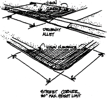
Wall sign (Signs). A sign attached to, erected against or painted on a wall of a building or structure, with the exposed face of the sign in a plane approximately parallel to the face of said wall and not projecting more than 12 inches. A sign painted on an awning in which the face of the sign is approximately parallel to and within 3.5 feet of the wall shall also be considered a wall sign. (5/98)
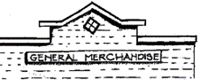
Warehouse. A place for the safekeeping of goods and materials for an industrial or commercial enterprise (also see Mini-storage warehouse). (5/98)
Water-dependent (Greenway). A use or activity which can be carried out only on, in or adjacent to water areas because the use requires access to the water body for waterborne transportation, recreation, energy production, or source of water. (5/98)
Water-related (Greenway). Uses which are not directly dependent upon access to a water body but which provide goods or services that are directly associated with water-dependent land or waterway use and which, if not located adjacent to water, would result in a public loss of quality in the goods or services offered. Except as necessary for water-dependent or water-related uses or facilities, residences, parking lots, spoil and dump sites, roads and highways, restaurants, businesses, factories and trailer parks are not generally considered dependent on or related to water location needs. (5/98)
Watercourse (Flood). A natural or artificial channel in which a flow of water occurs either continually or intermittently in identified floodplain. (5/98)
Wholesale trade. The bulk sale of goods for resale to a person other than the direct consumer. (5/98)
Wrecking yard. Property used for the business of buying, selling or dealing in vehicles and parts for the purpose of wrecking, dismantling, disassembling and offering for sale a used vehicle or components and is licensed under the laws of the state for that purpose. "Vehicle" includes all means of transportation that are registered with the department of motor vehicles. (5/98)
Yard, front. A yard extending across the full width of the lot, the depth of which is the minimum horizontal distance between the front lot line and a line parallel to the nearest point of the foundation of the main building; but no structures may encroach on any easement. (12/19)
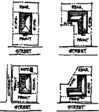
Yard, rear. A yard extending across the full width of the lot between the most rear portion of a main building and the rear lot line; but for determining the depth of the required rear yard, it shall be measured horizontally from the nearest point of the rear lot line or, if the rear lot line adjoins an alley, then from the centerline of the alley, toward the nearest part of the foundation of the main building; but no structures may encroach on any easement. (12/19)
Yard, side. A yard, between the main building and side lot line, extending from the front yard, or front lot line where no front yard is required, to the rear yard. The width of the required side yard shall be measured horizontally from the nearest point of the side lot line toward the nearest part of the foundation of the main building; but no structures may encroach on any easement. (12/19)
(Ord. No. 2025-895, § 1(exh. A), 7-7-2025)