
Millcreek City Zoning Code
18.34 AGRICULTURAL
ZONE AG
18.34.010 Purpose
The purpose of the Agricultural Zone (AG) is to provide areas in the City for low-density residential development along with limited agricultural uses.
18.34.020 Applicability
The Agricultural Zone (AG) is a legacy zone district and shall only be applied to existing properties and areas already included in the Agricultural Zones. No additional parcels, lots or land may be added to the AG Zone District. Development in the Agricultural Zone may be subject to the requirements set forth in MKZ 18.61, Sensitive Lands.
18.34.030 Permitted And Conditional Uses
Uses in the Agricultural Zone (AG) are as set forth in Table 18.34-1 Permitted and Conditional Uses in the Agricultural Zone. If a use is not explicitly designated in the table, then the use is prohibited. Certain use prohibitions or use limitations are listed in Table 18.34-1. Such use prohibitions or use limitations apply in addition to the general provision that uses not explicitly designated in the table are prohibited. An applicant seeking a Millcreek Business License may submit a Classification Request by following the procedure as set forth in MKZ 18.15.030 (J), to determine whether a proposed land use aligns with an existing land use listed in Table 18.34-1.
| Table 18.34-1 Permitted and Conditional Uses in the Agricultural Zone | ||
| Land Use | Limitations/references | |
| P= Permitted C= Conditional Use Review Required | ||
| Residential Uses | ||
| Bed and Breakfast | C | |
| Accessory Dwelling Unit | P | Limitations set forth in MKZ 18.71, Accessory Dwelling Unit Standards. |
| Dwelling, Single-Household Detached | P | |
| Home Business | P | Subject to MKZ 18.76, Special Business Land Use Regulations |
| Home Daycare or Preschool – up to 6 children | P | Subject to MKZ 18.76, Special Business Land Use Regulations |
| Home Daycare or Preschool – 7 to 12 children | C | Subject to MKZ 18.76, Special Business Land Use Regulations |
| Residential Facility for Elderly Persons or Person with a Disability | P | Limitations as set forth in MKZ 18.74, Residential Facilities for Persons With a Disability. |
| Short-Term Rental | P | Provided a valid Millcreek business license has been issued and is in good standing with respect to the property. Further limitations are as set forth in MKC 5.19, Short-Term Rentals. |
| Agricultural Uses | ||
| Commercial Agriculture | C | Requires a minimum of 1 acre |
| Noncommercial Agriculture | P | |
| Farm Stand | P | As set forth in MKZ 18.58, Temporary Uses and Structures |
| Greenhouse or Plant Nursery | P | May include limited retail sales of related products and requires a minimum lot or parcel size of 1 acre |
| Private Recreation Facilities | C | |
| Veterinary Clinic | P | Indoor kennels only |
| Civic and Institutional Uses | ||
| Public Use | P | |
| Quasi-Public Use | P | |
| Religious Assembly | P | |
| Schools, Public and Private | P | |
| Miscellaneous Uses | ||
| Accessory Uses, Accessory Buildings and Structures | P | As set forth in MKZ 18.59, Accessory Structures |
| Temporary Uses | P | As set forth in MKZ 18.58, Temporary Uses and Structures |
18.34.040 Spatial Requirements
Spatial Requirements. The minimum setbacks, maximum height, and lot or parcel size requirements are as set forth in Table 18.34-2 Spatial Requirements for the Agricultural Zone:
| Table 18.34-2 Spatial Requirements for the Agricultural Zone | |||||||
| Zone | Minimum lot area | Minimum lot width | Minimum Front Setback | Minimum Side Setback | Minimum Rear Setback | Maximum Height | Max. Lot or Parcel Coverage |
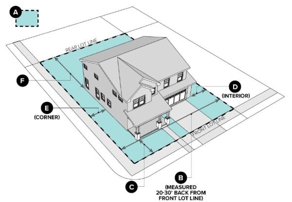
| AG | 10,000 square feet (A) | 75’ (B) | 30’ (C) | 10’ on interior lots or parcels (D) 20’ on a corner lot or parcel (E) | 15’ (F) | 30' | 31% |
- Setback Requirements. The minimum property size, width, setbacks, and maximum property coverage requirements are as determined by Table 18.34-2 Spatial Requirements for the Agricultural Zone.
- Side and Rear Setbacks for Civic and Institutional Uses. Civic and Institutional Uses require a minimum 20-foot rear and side yard setback when abutting and sharing a property line with a residential use.
- Rear Setback on Sloped Lots or Parcels. If the average slope of the original ground surface, as measured from the rear property line to the front property line, is more than 20 percent, then the rear setback shall be increased one additional foot for every one degree of slope in excess of twenty 20 percent, up to a maximum of 25 feet.
- Side Yard Setbacks on Lots Fifty Percent Larger Than Minimum Lot or Parcel Width. Lots or parcels with a width at least 50 percent larger than the required minimum lot or parcel width shall measure side yard setbacks as set forth in the following:
- The combined measurements of the side yard setbacks shall be at least 25 percent of the lot or parcel width.
- No side setback shall be less than the required minimum side yard setback.
- The width of the lot or parcel is measured as the diameter of the largest circle that can be inscribed entirely within the lot or parcel excluding any streams, floodplains, wetlands, areas of thirty percent slope or greater, or other natural hazard areas shall be excluded from the circle, as illustrated in Figure 18.34.1.
- A lot or parcel containing an existing legally-established two-household dwelling may be subdivided, subject to the standards as set forth in MKZ 18.26, Division of Legally-Established Two-Household Dwellings.
Figure 18.34.1 Combined Side yard Setback Spatial Requirements Diagram
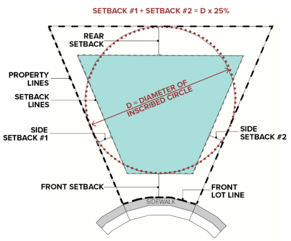
Figure 18.34.2 Spatial Requirements Diagram (letter labels related to Table 18.34-2)
18.34.050 Building Height And Building Envelopes
- Minimum height. All dwelling structures shall be a minimum of one story in height.
- Maximum Height. Maximum building height is as set forth in Table 18.34-3 Building Height and Building Envelope for the Agricultural Zone.
- Building Envelope. The height of structures may be further limited by the building envelope. The building envelope is formed by a box defined by the perimeter of the property line extended vertically perpendicular to the property line to a height and subsequent angle as set forth in Table 18.34-3. The entire building shall fit under this envelope except as described in the projections section below. See figures 18.34.3 and 18.34.4 for building envelope illustrations.
- Lots or parcels located in the AG zone determined by staff to be a Lot or Parcel of Record and are nonconforming due to minimum lot or parcel width and minimum lot or parcel area can qualify to use the sixty degree (60°) Building Envelope Angle and 12-foot Building Envelope Wall Height.
Figure 18.34.3 Agricultural Zone Building Envelope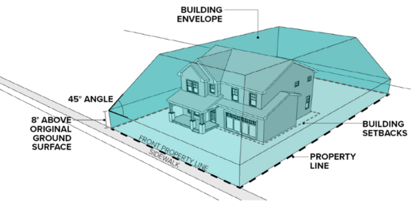 Figure 18.34.4 Sloped Building Envelope Example
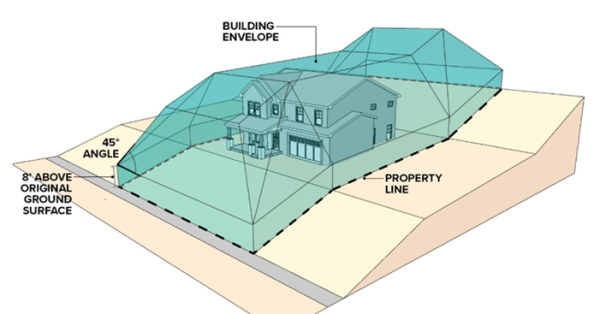
| Table 18.34-3 Building Height and Building Envelope for the Agricultural Zone | |
| AG | |
| Building Height Maximum | 30' |
| Building Envelope Wall Height and Angle | 30' |
| Building Envelope Angle | 0 degrees |
18.34.060 Projections
Dormers, Gables, and non-habitable architectural elements may project beyond the building height envelope if they meet the following criteria, as illustrated in Figure 18.34.5:
- Dormers
- The width of the dormer shall not exceed 14 feet;
- Multiple dormers shall be spaced such that the distance to the edges of the roof is at least one-half the distance between dormers; and
- The dormer shall be no higher than the ridge of the roof.
- Gables
- The height of the gable is less than 1.75 times higher than the point where the graduated building height envelope intersects the gable;
- The height of the gable is less than the maximum building height; and
- The length of the gable comprises no more than 25 percent of the length of the building façade.
Figure 18.34.5 Dormer and Gable illustration with height envelope exception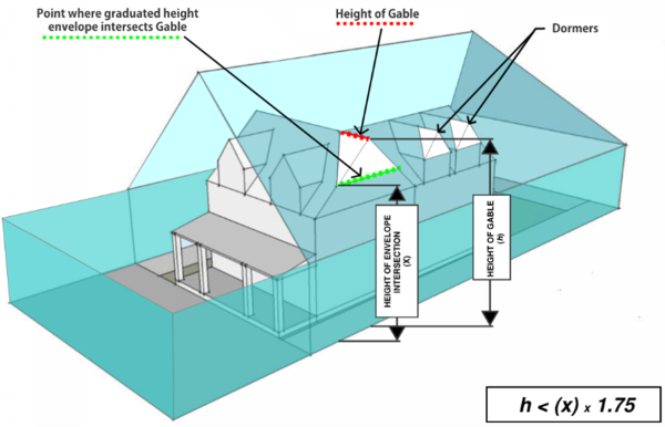
18.34.070 Setback Encroachments
The following may be erected on, or encroach into the required yard setbacks:
- Fences and walls in conformance with this code.
- Landscape elements, including trees, shrubs, and other plants.
- Utility or irrigation equipment or facilities.
- Decks, patios, porches, driveways, sidewalks, stairs, landings, not exceeding two feet (2’) above grade.
- Covered porches and balconies porches may project up to 10 feet into the front yard or street side yard setback if they meet the following criteria:
- Porches and balconies shall remain unenclosed or “open style” (no walls, doors, windows, screens, etc.) except for the minimum required handrail.
- Porches and balconies shall not encroach into any easements or clear vision site areas.
- Porches, balconies, stairs, landings, eaves which project into the setbacks, shall not be located nearer than 15 feet from a street property line, or project outside of the building height envelope.
- Other architectural elements which are not used as habitable space.
- Cornices, eaves, sills, planter boxes, stairways, landings, awnings, window wells, or similar architectural features attached to the building and not enclosed by walls, extending not more than two feet (2') into a side yard or four feet (4’) into the front or rear yard. In no case shall a side yard setback be less than six feet (6’).
- Chimneys, fireplace keys, box or bay windows or cantilevered walls attached to the building, no greater than eight feet (8') wide, extending not more than two feet (2') into a side yard, or four feet (4') into a front or rear yard. In no case shall a side yard setback be less than six feet (6’).
18.34.080 Articulation
To avoid a large, continuous building mass of uniform height; no portion of any building shall continue more than forty feet horizontally without a minimum of an eighteen-inch break in the roofline or introduction of a contrasting architectural element such as an overhang, projection, or inset of a minimum depth of two feet (2’) from the primary façade plane, to create shadow patterns along the elevation of the building.
18.34.090 Neighborhood Compatibility Modification
The Neighborhood Compatibility Modification (NCM) allows for modified standards from one or more of the spatial standards based upon the compatibility of the proposed residential development application with other properties/dwellings in the proximate neighborhood. The Planning Director may approve an NCM request at time of site plan submittal provided the following conditions are met:
- Evidence. Compliance with the corresponding neighborhood conditions must be established by a survey from the proximate neighborhood, defined as a 200-foot radial distance from the property boundary. Survey submitted must be completed by a surveyor licensed to practice in the State of Utah.
- Submittal. NCM requests shall be submitted on a separate form and shall include an additional review fee as set forth in the Millcreek Consolidated Fee Schedule.
- Permissible Modifications. NCM Standards. Building height, setbacks and lot or parcel coverage modifications may be accommodated if the request does not exceed the allowances as set forth in Table 18.34-4 NCM Standards.
- Non-Permissible Modifications. Building envelope, mass and scale, and accessory structure modifications do not qualify under the NCM.
Table 18.34-4 NCM Standards Zone (H) Lot or Parcel Coverage Front Setback Side Setback Rear Setback Max Height AG 33' 36% (1) The average of all lots or parcels within the proximate neighborhood that fronts to the same street, road, or right-of way. Combined side yard shall be at least twenty-five percent (25%) of the lot or parcel width, and no less than six feet (6’) on each side. The average rear yard setback that are on six lots or parcels of the applicant’s choice within the proximate neighborhood, and no less than 15’ The maximum building height that may be approved by the Planning Director or designee under the NCM standards is the lesser of: 1. Three feet plus the average maximum ridge height of residential structures that are on six lots or parcels of the applicant’s choice that are within the proximate neighborhood; and 2. The maximum height of the zone specified in column (H) of Table 18.37-4 NCM Standards. - Table Notes.
- Lot or parcel coverage for all lots or parcels may not exceed more than 1.15 times the average coverage of proximate neighborhood lots or parcels.