
Millcreek City Zoning Code
18.72 BUILDING
HEIGHT
18.72.010 Purpose
The purpose of this Chapter is to determine how building and structure height is measured and how it is applied.
18.72.020 Applicability
This Chapter is applicable to buildings and structures in all zones throughout Millcreek, except for fences and walls. Measurement of fences and walls is set forth in MKZ 18.66.090. The maximum allowed height of projections as described in MKZ 18.72.040 may be further limited by the standards in the underlying zone.
18.72.030 Measurement Of Building Height
- The height of a building is measured as the vertical distance above the lowest original grade at any point on the perimeter of the building to the highest point, generally as depicted in Figure 18.72.1.
- The highest point includes the coping of a flat roof, or to the deck line of a mansard roof, or to the highest point of pitched or hipped roofs, or gambrel roofs.
- Buildings may be stepped to accommodate the slope of the terrain provided that each step shall be at least 12 feet in horizontal dimension. The height of each stepped building segment shall be measured as required in Subsection A.
Figure 18.72.1, Measurement of Building Height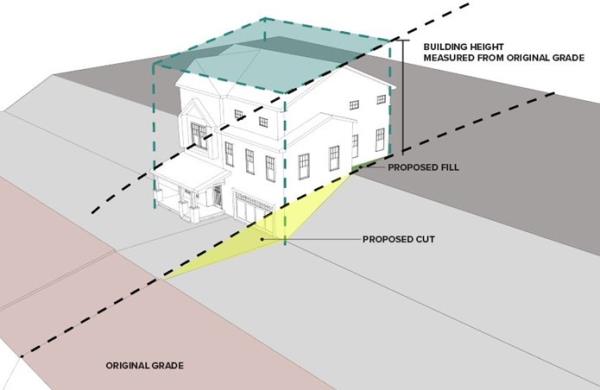
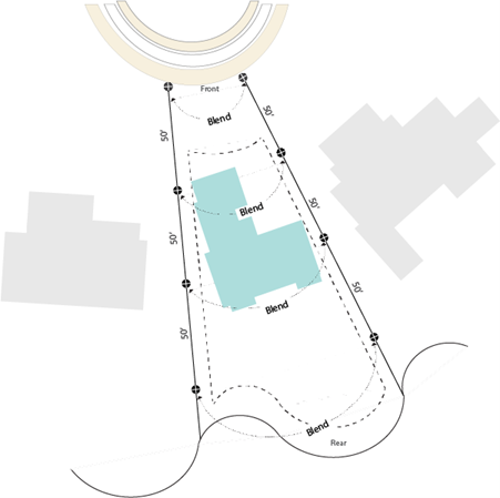
- The original grade is the elevation of the ground surface in its natural state before any human-caused alterations including but not limited to grading, excavation, or filling, excluding improvements required by zoning or subdivision ordinances. When the elevation of the original ground surface is not readily apparent, the Planning Director shall determine the elevation of original grade using one of the following methods:
- The original grade established related to the most recent building permit activity on the property.
- Referencing original grade where the developed area appears to meet the undeveloped portions of the land. The estimated grade shall tie into the elevation and slopes of adjoining properties, measured along the side property lines from the front property line to the rear property line, measured in 50-foot intervals, without creating a need for new retaining wall, abrupt differences in the visual slope and elevation of the land or redirecting the flow of runoff water. Original grade is the average of the elevations measured at the side property lines at each interval line, as illustrated in Figure 18.72.2.
Figure 18.72.2, Referencing original grade where the developed area appears to meet undeveloped portions of the land.
18.72.040 Height Projection Allowances
- For multiple-household dwellings, mixed use buildings, and any building housing a non-residential use located in an RM, MD, MD-3, C-1, C, M, CCOZ, or VCSD Zone, the following height projections are allowed:
- Roof structures for the housing of elevators, stairways, tanks, ventilating fans or similar equipment required to operate and maintain the building, and fire or parapet walls, skylights, towers, steeples, flagpoles, chimneys, smokestacks, water tanks, wireless or television masts, theater lofts, silos, or similar structures, may be erected above the height limits prescribed in this title, but no space above the height limit shall be allowed for the purpose of providing additional floor space. Maximum additional height for projections is as follows:
- RM, MD, MD-3, C, M, CCOZ, VCSD Zones: 14 feet
- C-1 Zone: 10 feet
- IF Zone: Maximum height is as set forth in MKZ 18.45.070 (C).
- Fire or parapet walls may be erected above the height limits prescribed in this title. Maximum additional height for fire or parapet walls is as follows:
- RM, MD, MD-3, C, C-1, M, CCOZ and VCSD Zones: 5 feet
- IF Zone: Maximum height is as set forth in MKZ 18.45.070 (C).
- No structures identified above except towers, stairways and elevators, fire or parapet walls, and solar panels, may be located nearer than 10 feet to the edge of the building.
- Roof structures for the housing of elevators, stairways, tanks, ventilating fans or similar equipment required to operate and maintain the building, and fire or parapet walls, skylights, towers, steeples, flagpoles, chimneys, smokestacks, water tanks, wireless or television masts, theater lofts, silos, or similar structures, may be erected above the height limits prescribed in this title, but no space above the height limit shall be allowed for the purpose of providing additional floor space. Maximum additional height for projections is as follows:
- Public or semipublic utility buildings, when authorized in a zone, may be erected to a height not exceeding 40 feet if the building is set back from each otherwise established building line at least one foot for each additional foot of building height above the normal height limit required for the zone in which the building is erected.
18.72.050 Certification And Verification Of Building Heights
- Prior to being issued a building permit, the applicant shall certify on a form provided by the City that the building or structure complies with all applicable height requirements.
- Prior to being issued a Certificate of Occupancy, the building official or designee shall verify that the building or structure complies with all applicable height requirements. As part of the verification, the building official or designee may require the applicant to supply an elevation certificate prepared by a professional surveyor on a form approved by the City prior to receiving approval for a footing or foundation. If, during inspection, the City determines that a building or structure does not comply with all applicable height requirements, it is the responsibility of the applicant to modify the building or structure to ensure compliance with all applicable height requirements prior to being issued a Certificate of Occupancy.