
Millcreek City Zoning Code
18.61 SENSITIVE
LANDS
18.61.010 Purpose And Intent
- To preserve the distinctive features and the natural setting of the City and to promote development that recognizes and respects the character of the land.
- To identify and document sensitive lands that shall be protected from development and to guide sensitive lands related to open space designations in development proposals.
- To identify certain hazardous conditions that require buffering, avoidance, or other engineering techniques to allow for safe beneficial development.
- To provide for the health, safety, and welfare of residents, as well as protect urban and nonurban development, the good order and aesthetics of Millcreek, and protection of property values as set forth in Utah Code Section 10-9a-102(1), General land use authority.
18.61.020 Applicability
- A Sensitive Lands Area is defined as any area that is either:
- Located within the affected areas identified on the Sensitive Lands Map, adopted and amended from time to time by the Millcreek City Council; or
- Contains sensitive lands features as described in this section; or
- Affected by geological hazards identified in a Geotechnical Report, a topographical survey, or soils study.
- Any land use application for development located in a Sensitive Lands Area including but not limited to building permits for a new structure or existing structures that add additional square footage to the primary or secondary structure, permitted and conditional uses, preliminary and final subdivision plats, shall include a sensitive lands identification analysis addressing the requirements of this chapter through a Geotechnical Report that identifies/analyzes not only geologic hazards but also the other sensitive lands features as described in this chapter.
- The applicant shall provide a Geotechnical Report or other required reports based on the Sensitive Lands Area map, or if a property is determined to be in a Sensitive Lands Area by a previous Geotechnical report, topographical survey, or soils study. The required reports are shown in Table 18.61-1, and such reports will vary based on the severity and type of sensitive lands found within the proposed development. Additional requirements may be found in the applicable application checklist.
- The City retains a City Geologist to review, analyze, suggest modifications, and approval the reports. Any costs incurred by the City Geologist, including contracted specialized engineering or geotechnical services, site inspection, testing, and review time due to the proposed development will be passed along to the applicant or developer and deposited with the City. Such costs shall be based on an estimate provided by the City Geologist.
- Existing properties located in low liquefaction potential areas with slope angles less than 15% may be exempt from a full Geotechnical Report requirement, provided that soil type and water table depth information is furnished to the City to assure foundation suitability. Geotechnical Reports are not required for fences but are required for any retaining wall or accessory building over 1,000 square feet when located in a Sensitive Lands Area.
- Any sensitive lands identified as a result of this chapter’s requirements shall be acknowledged in the development proposal. Some sensitive lands cannot be mitigated, so the development design shall avoid and preserve the identified sensitive lands areas as undevelopable land. Such land shall be designated on the site plan or subdivision plat in a manner that permanently restricts the area from development.
- A grading plan and the limits of disturbance shall accompany any development plan in a sensitive land area. Limits of disturbance shall be defined by the least area needed to construct the development, required setbacks on the site, a prescribed buffer area if located in the Wildland Urban Interface, and the avoidance of any unmitigable sensitive lands. Limits of Disturbance are further described in MKZ 18.61.070 (B).
- Despite the established spatial requirements in any underlying zone, additional lot coverage limits, setbacks, or other spatial requirements may be required in a Sensitive Lands Area, due to the requirements of this chapter.
18.61.030 Sensitive Lands Description
Sensitive Lands contain characteristics that can influence, modify, or limit development patterns through physical or regulatory restrictions. Sensitive lands features covered by this chapter are described as follows:
- Topographical Features. The types of lands represented in this typology include slopes that average 15 percent over a 50-foot interval in any direction, wetlands, rock outcroppings larger than 10 feet wide and 10 feet tall, avalanche zones, alluvial fans, rock fall areas, gullies/ravines deeper than 10 feet and wider than 20 feet), intermittent or constant flow stream corridors, ridgelines, springs, species protection, Wildland Urban Interfaces, and floodplains. Additional requirements for floodplains are found in MKZ 18.62, Floodplain Hazards Mitigation.
- Subsurface Features. Soils, saturated soils, and soil structures such as areas of liquefaction potential, surface fault rupture hazard areas, and debris flow areas. Soil types used to determine surface stability, foundation stability, movement potential, depth to bedrock, and shallow water table levels, may also reveal factors to consider for avoidance/preservation and/or design modifications when determining the extent of sensitive lands.
18.61.040 Identification Required
Designation and possible preservation or avoidance of the identified Sensitive Lands features and their associated area(s) in their natural state is required. A Sensitive Lands Geotechnical Report is required for lands located in the Sensitive Lands Map or where a Geotechnical Report identifies sensitive lands issues. A Sensitive Land Area shall be shown in concept plans, existing properties, site plans, and preliminary and final subdivision plats. It is the intent of these requirements to promote a development design that incorporates and integrates the sensitive lands into the development design process as valued aspects of that design. These characteristics need identification and are significant factors that determine how sensitive lands should be reflected in the design of a particular development site. Sensitive lands features shall be shown on the development site plan and detailed by the appropriate study, as required by this chapter.
18.61.050 Remediation For Mitigatable Sensitive Lands
Certain Sensitive Lands have the potential to be remediated and/or mitigated. Determinations and mitigation techniques proposed that, when reviewed by the City Engineer and City Geologist, do not clearly resolve any identified issues may be subject to a Peer Review at the City’s discretion. The process for a Peer Review is set forth in MKZ 18.61.060. The City Engineer and City Geologist shall have the right to review, provide comments, suggest changes, and ultimately approve, deny, or modify the mitigation techniques. The applicant’s geotechnical engineer shall stamp such mitigation techniques. All disturbed lands shall be rehabilitated and revegetated, except where buildings and impervious surfaces are proposed on the approved site plan or subdivision plat.
18.61.060 Dispute Resolution And Peer Review
The City may seek a third-party review of the information provided by the developer or applicant as part of an application compliance review set forth in MKZ 18.14.070, Application Compliance Review for All Other Applications.
18.61.070 Development Design Considerations
- Grading Plan Required. All development plans in a Sensitive Lands Area shall include a grading plan, subject to the requirements for Engineering Grading Plans as set forth in the Engineering Requirements Checklist , to assure that the development minimizes land disturbance, that erosion and stormwater are retained on-site to the greatest extent possible, and conforms to MKC Title 14, Engineering Standards. Topsoil that is removed from the site during construction shall be conserved for later use on areas requiring revegetation or landscaping, such as cut-and-fill slopes. Such plans shall establish a limit of disturbance indication on the site plan where development activity will be contained. Sites with slopes that average over 20% shall limit their grading to no more than 60% of the lot area.
- Limits of Disturbance. The limits of disturbance (LOD) is defined as the area(s) in which construction and development activity shall be contained, including development and construction of the principal building, accessory structures, recreation areas, utilities, services, driveways, storm drainage, and other similar improvements. LOD areas shall not encroach into setbacks required by the underlying zone or the specified buffers as defined in this chapter. An LOD Site Plan Example is illustrated in Figure 18.61.1.
- LODs shall be identified for development on property affected by or located within 100 feet of any of the topographical features identified in MKZ 18.61.030 (A).
- Maximum Area of an LOD for Single-Household and Two-Household Dwellings:
- For single-household or two-household dwellings and accessory buildings located on lots or parcels less than one acre in size, the LOD area is limited to 20,000 square feet.
- For single-household or two-household dwellings and accessory buildings on lots or parcels one acre in size or greater, the limits of disturbance are limited to twenty thousand 20,000 square feet plus an additional square footage of 20 percent of the acreage over one acre.
- Exclusions from LODs. The following do not need to be included in the LOD:
- Up to 10 feet of paved or unpaved shoulders for driveways.
- Areas consisting of natural ponds, streams, trees, and other vegetation where no grading work is done. Such areas shall be avoided, buffered, and/or preserved.
- Updates to LODs. Due to unforeseen circumstances, LODs may be required to be updated during the construction process. In the case of an amendment, a revised LOD shall be submitted to the City for a site plan review.
- Delineation of LODs On Site. All LOD areas shall be surveyed and staked prior to construction and maintained throughout the construction of the site. A LOD shall be delineated on-site with fencing or other separation methods approved by the Planning Director prior to the commencement of excavation, grading, or construction activities on the site.
Figure 18.61.1, LOD Site Plan Example.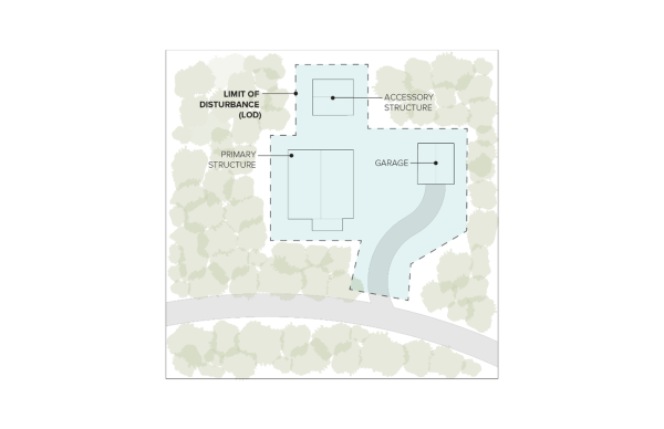
- Slope Cuts and Grading. Slope cuts and grading shall conform to the following:
- Final plans must be in accordance with a grading and excavation plan and the Geotech report for the site, as approved by the City Engineer, prior to issuing a building permit. Figure 18.61.2 illustrates a development plan that minimizes cuts.
- Cantilevers/eaves located on a second story and above may encroach into the LOD and/or zone setbacks by up to three feet (3’), provided the cantilevered setback can be constructed entirely from within the LOD.
Figure 18.61.2, A Development Plan that Minimizes Cuts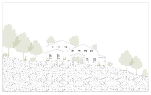
- The original ground surface of a lot may not be raised or lowered more than four feet (4’) at any point for the construction of any structure or improvement, except that the site’s original ground surface may be raised or lowered eight feet (8’) if a retaining wall or terracing is used to reduce the steepness of human-caused slopes. Terraces and retaining walls must comply with the requirements of MKZ 18.66, Fencing and Retaining Walls.
- Separate building pads for accessory buildings other than private garages, (including but not limited to accessory dwelling units, guest houses, barns, recreational structures such as tennis courts, swimming pools, and similar facilities) are prohibited except where the natural/original slope is 20 percent or less.
- The following limits apply to graded or filled human-caused slopes:
- Slopes of 25 percent or less are encouraged wherever possible.
- Graded or filled human-caused slopes may not exceed the maximum slope supported by a geotechnical study and constructed per the geotechnical engineer’s requirements not to exceed 50 percent.
- Cut human-caused surfaces or slopes may not exceed a slope of 50 percent unless it is substantiated, on the basis of a site investigation and submittal of a soils engineering or Geotechnical Report prepared and certified by a qualified professional, that a cut on a steeper slope will be stable and will not create a hazard to public or private property.
- All cut, filled, and graded slopes shall be re-contoured to the natural, varied contour of the surrounding terrain.
- Stormwater retention or detention is prohibited on slopes greater than 25 percent.
- Excavation for footings and foundations shall not occur outside limits of disturbance and shall be minimized to lessen site disturbance and ensure compatibility with hillside and sloped terrain. Intended excavation must be supported by detailed engineering plans submitted as part of the application for site plan approval.
- Stormwater. Storm drainage plans shall include a system design to return collected and clarified waters to the natural drainage channels or to the adjacent ground. All developments may be required to obtain a Storm Water Pollution Prevention Plan (SWPPP) and a Utah State Department of Environment Quality General Construction Storm Water (UPDES) Permit at building permit issuance as determined by the City Engineer.
- Soils Conditions. Geotechnical Reports, are required as set forth in this chapter and in the Engineering Requirements Checklist and are catered to the type of Sensitive Lands encountered, shall also include an analysis of the soil types and their potential for movement when additional moisture is applied, as may occur from heavy rainfall or melting snow, landscape irrigation and/or impervious surface runoff or saturation, on any lot with a slope over 15 percent. Geotechnical Reports shall also identify:
- The depth to water table, and
- Potential fluctuations in seasonal water tables, if buildings with basements are to be constructed within the proposed development. In the absence of a year-long analysis of water table fluctuations, the time period to be studied is from March 15 to June 15 and such fluctuations may be estimated if the timing of such studies is contrary to the development schedule. Additional requirements for drainage of subsurface water are set forth in MKC 17.12.
- Trails. After identifying/documenting (or delineating in the case of wetlands) any sensitive lands as defined above, and reviewing the Millcreek Sidewalk and Trails Master Plan, the Millcreek General Plan, the Salt Lake County Regional Trails Master Plan, as part of the design process of a development, and as part of the concept plan submission, each development shall include a conceptual design to assess how the development will be designed to preserve the identified sensitive lands and evaluate the potential to extend trail systems to and within the area. Trails are designated as a conditional use on slopes up to 50 percent, and prohibited from areas on slopes greater than 50 percent, and may disturb areas they traverse.
- Mitigating Cuts and Fills. The development shall mitigate the visibility of cuts and fills and buildings on hillsides that are visible from the adjacent streets. Mitigations shall include methods to conceal such cuts and fills and buildings, such as evergreen landscaping, hill terracing, use of earth-tone colors on structures, or the reduction of the width of a required street cross-section, subject to approval of the City Engineer or Fire Marshal.
18.61.080 Development Limitations And Prohibitions
All new development, including any subdivision of land, shall avoid and preserve the following areas as undisturbed and natural open space, as provided below:
- Slopes 30% or greater: Except for the installation of fencing and live plant materials and the construction of trails, development is prohibited on slopes of 30 percent (30%) or greater. Slopes of 30 percent or greater shall remain undisturbed, unless a property has a natural, contiguous building area based on the original grade that can encompass the proposed building, and has a buildable area with a minimum of 5,000 square feet at or below 30 percent natural grade. All such properties shall include specific engineering designs to contain runoff, erosion, and pollution on the subject property during and after construction. The applicant shall identify a Limits of Disturbance on the site plan or plat, and shall obtain a land disturbance permit, and possibly a SWPPP permit prior to obtaining building permit. This includes the prevention of any materials caused by erosion flowing out onto adjacent trails, sidewalks, and streets, as well as adjacent fences and properties, and erosion onto the sensitive lands buffer areas. Additional setbacks from portions of the property that are steeper may be required as set forth in the Geotechnical Report, or as identified in adopted building codes. Where slope maps are required as part of a Geotechnical Report, they shall include:
- A base topographical map of the subject site, prepared and signed by a Utah licensed civil engineer or land surveyor. This base topographical map shall include all adjoining properties within 150 feet of the site boundaries to portray the site's context.
- This slope analysis shall be prepared using CAD- or GIS-based software specifically designed for such purpose. Contours on the exhibits shall be prepared using no greater than two-foot (2') contour intervals with ten-foot contours clearly labeled and at a scale of not less than one inch equals 100 feet (1" = 100'). The slope analysis exhibit shall delineate slope bands, with contrasting colors, for the following slope ranges: zero percent (0%) to 15 percent,15.01 percent to 20 percent, 20.01 percent to 25 percent, 25.01 percent to 30 percent, 30.01 percent to 50 percent, and 50.01 percent or greater.
- A tabulation chart indicating the land area in acres within each slope category as identified herein.
- A sufficient number of slope cross sections to clearly illustrate the extent of the proposed grading. The slope cross sections shall:
- Be drawn at the same scale and indexed, or keyed, to the existing topography, grading plan, and project site map. Both vertical and horizontal scales shall be indicated and be of the same scale. The slope cross section shall extend at least 150 feet outside the project site boundary to clearly show impact on adjacent property. Slopes shall be calculated in intervals no greater than 40 feet along the cross sections.
- At a minimum, sections shall be drawn along those locations of the project site where:
- The greatest alteration of existing topography is proposed;
- The most intense or massive development is proposed;
- The site is most visible from surrounding land uses;
- Where grading will impact natural drainage conditions.
- At least two (2) of the slope profiles shall be roughly parallel to each other and roughly perpendicular to existing contour lines.
- The slope cross sections shall be stamped and signed by a Utah licensed professional proficient in creating such cross sections indicating the datum, source, and scale of topographic data used in the slope profiles. The signer shall attest that the slope profiles have been accurately calculated and identified.
- The slope cross sections shall show the existing and proposed topography, structures, driveways, and roadways. The proposed topography and features shall be drawn with a solid line, while the existing topography and features shall be drawn with a dashed line.
- The slope analysis calculations shall be prepared by a Utah licensed professional who is proficient in creating the exhibits using computer software designed for preparing said exhibits.
- Cuts and fills shall be avoided in project design to the greatest extent possible and shall not exceed a 50 percent slope. Retaining walls shall satisfy the standards for retaining walls as set forth in MKZ 18.66, Fences and Retaining Walls. Terraces may be created at lesser heights to meet slope-related issues, but the minimum terrace width shall be in six-foot (6’) intervals. Development affecting slopes of 20 percent or greater shall submit plans that conform to any City Standards, utilize Low Impact Development techniques, and may require specialized storm water permits such as a SWPPP. Revegetation with native plants and ground covers of disturbed areas is required as soon as possible or within 6 months for any grading performed for road work and after the occupancy of a home. Streets, roads, alleys, or driveways may not cross slopes that average (in any fifty-foot interval) 30 percent (30%) or greater. Public or private streets in a sensitive land area shall not exceed 12 percent slopes. Driveways or private streets shall not exceed 10 percent slopes within 20 feet of a public street.
Avalanche paths. Avalanche paths shall be identified, and development shall avoid such paths as recommended by a qualified Geotechnical Engineer.
- Fault lines, scarps, landslides, rock outcroppings, rock-fall, alluvial, fans and mud/debris flow areas: These topographical features shall be avoided and mitigated as recommended by a Geotechnical Engineer licensed to practice in the State of Utah.
Figure 18.61.3, Buffer Example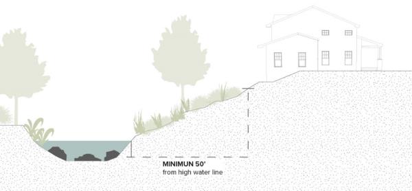
- Stream beds (including intermittent), gullies, flood channels, flood plains, areas of springs, seeps and surface water are subject to the following additional requirements, generally as depicted in Figure 18.61.3:
- Building Setbacks:
- Buildings setbacks shall be no less than 50 feet from the top edge of a stream bank or a high water line of a perennial stream.
- Building setbacks shall be no less than 50 feet from a gully, flood channel, spring, or any other surface water feature, unless otherwise specified by Title 14 or supported through a geotechnical report.
- Amenities, streets, and aisleways serving multiple-household dwellings or mixed use, commercial, or institutional development in a C-1, C, RM, MD, MD-3, IF, CCOZ, or VCSD zone may be located within 50 feet from the top edge of a stream bank or a high water line of a perennial stream, subject to additional landscaping standards as set forth in MKZ 18.64.130, Landscaping along Natural Waterways.
- Pollution sources including but not limited to fuel tanks and their containment systems, animal yards, septic tanks, and parking lots, shall be set back at least 50 feet from the hydrologic feature or as required by the Utah Department of Water.
- Additional vegetation may be required between the hydrologic features and development for erosion control (with limited fertilizer or pesticide use in natural corridors) or public amenities. Hydrologic features that are accompanied by an amenity such as a park or trail shall include sufficient open area along and surrounding the hydrologic feature to ensure ample room to protect the feature and to provide an area for the enjoyment of the amenity.
- Any development within a floodplain shall comply with the standards and permitting requirements of MKZ 18.62, Floodplain Hazard Mitigation and MKC Title 17 Flood Control and Water Quality.
- Landscaping within 100 feet of a stream bed is subject to the standards as set forth in MKZ 18.64.130, Landscaping along Natural Waterways.
- Building Setbacks:
- Canals. Development shall avoid destabilizing the downhill portion of canals. No cuts shall be permitted below a 50 percent slope measured from the downhill bank of a canal without mitigation/safety strategies proposed by a geotechnical engineer, as illustrated in Figure 18.61.4. Construction adjacent to a canal shall be coordinated with the facility/canal owner and is subject to review and approval by the facility/canal owner. Construction adjacent to a canal shall allow inspections by the facility owner during construction and when construction is complete the facility owner shall provide a letter of acceptance.
Figure 18.61.4, Canal Bank Stabilization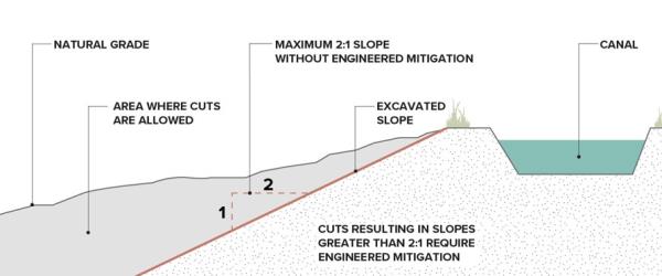
- Identified wetlands. Identified wetlands shall be delineated using the Section 404 definition and procedures set forth in the Clean Water Act. Protected wetlands shall be accompanied by additional open lands when they are adjacent or combined with usable open space and trails, with such adjacent areas averaging 50 feet wide from the defined edge of the wetland. Pollution sources such as fuel tanks and their containment systems, parking lots, etc. shall be set back 100 feet from the identified wetlands, unless diversionary devices, as recommended by a Geotechnical engineer, and approved by the City, are constructed to solve potential pollution problems. Additional vegetation may be required in these buffer areas for erosion control (with limited fertilizer or pesticide use) or for public amenities, to reduce the illicit discharges as set forth in MKC 17.22.130.
- Wildfire Potential, Potential wildfire areas shall be assessed, and mitigation strategies shall be applied according to the Utah Wildland Urban Interface Code (WUI) best practices. Best practices suggest low fire hazard buffers surrounding lots and/or buildings in areas to be developed that are prone to wildfires. A specific plan addressing mitigating measures to reduce the potential for wildfire damage is required.
- Ridgelines. Unless otherwise allowed by this title, no development may break a ridgeline. In addition to ridgeline as defined in this Title, for the purposes of this chapter, ridgelines also include ridges that are visible as viewed from a ground level vantage point within the Wasatch Boulevard right-of-way.
18.61.090 Development Constraints For Certain Sensitive Lands
The following sensitive lands with potential hazards require additional mitigation techniques in any new development, including the subdivision of land, and the developer shall provide mitigation for such hazards when they apply. The City requires geological hazards disclosure and acknowledgment and acknowledgement of any associated geologic hazard site-specific studies to be recorded on the property title or on the subdivision plat. A Geological hazards disclosure and acknowledgement shall be made on a form provided by the City. Such mitigatable hazards and mitigation techniques (practicable or available) shall include, but are not limited to the following:
- Alluvial fan, flood/debris flow, liquefaction potential, collapsible soils, and shrink-swell soils. Mitigation techniques shall follow the advisement of a qualified Geotechnical Engineer and may be subject to peer review, at the developer’s cost.
- Shallow groundwater. Areas with ground water within 3’ of the ground surface, shall require additional analysis to assess their feasibility for development. If areas of shallow ground water are found that prohibit or impact foundations, such areas shall be noted in the concept design (if required) and carried forward on the preliminary and final plats. Possible mitigation techniques include the installation of a foundation drain (s) and sump pump (s), possible prohibition of basements, or other mitigation techniques as provided on the advisement of a qualified Geotechnical Engineer.
- 100-year flood zones. Mitigation techniques shall follow the procedures of MKZ 18.62, Floodplain Hazards Mitigation.
18.61.100 Geotechnical/Geologic Hazard And Engineering Geology Reports
- In addition to the checklists required by the City through Engineering and Planning, this section describes requirements for site-specific geologic hazard studies and reports. If the report conclusions are questioned, they may be subject to a Peer Review as set forth in MKZ 18.61.060. This requirement is based on other previously mapped geological hazards shown on the Sensitive Lands Map. Identified Sensitive Lands Areas are based on previous area studies and mapping that designated certain areas of the City to have potential geo-hazards or sensitive lands.
- All Geotechnical Reports shall include a soil type, condition, percolation test, and water table analysis. Geotechnical Reports are classified as follows:
- Geotechnical Report, Level 1 means a Geotechnical Report that includes a soils analysis and recommendations on structural requirements for footings and foundations, and other items as required by the Engineering Review Checklist.
- Geotechnical Report, Level 2 means a Geotechnical report for a development in a Sensitive Lands area that includes an analysis of any topographical or subsurface feature on the property that is identified as a sensitive lands area, and must satisfy the requirements of MKZ18.61.100 (D)(8), and other items as required by the Engineering Review Checklist.
- Geotechnical Reports are required in the following cases:
- A geotechnical report is required for the development of any critical or essential facility.
- A geotechnical report is required for any development including additions to existing single-household dwellings located on property affected by or within 100 feet of the following topographical features:
- Debris flow, rockfall, or landslide areas;
- Avalanche paths;
- Slopes in excess of 15 percent
- A geotechnical report is required for any development on property subject to a surface fault rupture study area, including additions to existing single-household dwellings.
- A geotechnical report is required for the following development types in high-and moderate liquefaction potential areas:
- Single-Household Subdivisions of four dwellings or more.
- Multiple-Household Developments of 4 or more units.
- Industrial, Institutional, or Commercial Buildings that are either greater than 5,000 square feet in area or more than one story in height.
- Certain studies require an analysis method, as set forth in Table 18.61-1, Geotechnical/Geologic Hazard and Engineering Geology Reports. Some areas have more than one hazard or sensitive land feature that generates the need for certain studies, including:
Table 18.61-1 Geotechnical/Geologic Hazard and Engineering Geology Reports Sensitive Lands features - See sensitive lands map Geotechnical Report Level 1 Geotechnical Report Level 2 Liquefaction Analysis WUI prevention report Other Reports Surface Fault Rupture NA Yes No No Low Liquefaction Potential No No No No Moderate Liquefaction Potential Yes No Yes No High Liquefaction Potential No Yes Yes No Landslide, Debris Flow, rockfall, rock outcroppings No Yes No No Avalanche No Yes No No Slopes greater than 20% No Yes No No Shallow Water Table No Yes Yes No Flood Zone using FEMA A and AE Flood Zone maps No Yes Yes No Stream Corridor including intermittent streams, springs, and other water bodies No Yes Yes No Saturated or Movement-Prone Soils No Yes Yes No Alluvial Fans No Yes No Yes, if located next to wildlands Include landslide and debris flow analyses Wetlands No Delineate – see MKZ 18.61.080 (E) Yes No Gullies/ravines deeper than 10’ and wider than 20’ No Yes No No Wildland Urban Interface No No No Yes
The methods to be used in Geotechnical and Liquefaction studies for certain sensitive land features are detailed below:
- A Geotechnical Report that includes a geologic hazards investigation and assessment shall be prepared by a qualified engineering geologist, except as provided below. The report shall be site-specific and shall identify all known or suspected potential geologic hazards, originating on-site or off-site, whether previously mapped or unmapped, that may affect the particular property. All reports shall be signed and stamped by the preparer and include the qualifications of the preparer(s).
- Fault rupture hazard reports shall contain all requirements as described in the document “Minimum Standards for Surface Fault Rupture Studies” published by Salt Lake County and incorporated by reference. Fault study reports shall be prepared, signed, and stamped by a qualified engineering geologist.
- Liquefaction analyses shall contain all requirements as stated in the document “Liquefaction: A Guide to Land Use Planning” published by Salt Lake County and incorporated by reference to this ordinance. Liquefaction analyses shall be prepared by a qualified professional geotechnical engineer and shall include the professional engineer’s original stamp and signature.
- Debris flow hazard studies and reports shall include test pits or trench logs (scaled one inch to five feet), estimates of the number and frequency of past events and their thicknesses, volume, and maximum clast sizes; and i estimates of the recurrence, depth, and impact forces anticipated in future events. While debris flow hazard analyses may require contributions from hydrologists and engineers, a qualified engineering geologist shall control and prepare the debris flow report.
- Landslide reports shall be prepared in accordance with the Utah Geological Survey’s “Guidelines for Evaluating Landslide Hazards in Utah” (Hylland, 1996). Landslide reports shall be prepared, signed, and stamped by a qualified engineering geologist, including the preparer’s qualifications. Slope stability or other analyses included in these reports shall include static and dynamic conditions and shall be prepared by a qualified professional geotechnical engineer licensed to practice in the State of Utah and include the professional engineer’s original stamp and signature.
- Snow avalanche hazard reports shall be prepared in accordance with the document “Snow- Avalanche Hazard Analysis for Land Use Planning and Engineering” (Colorado Geological Survey Bulletin 49) or other appropriate references. An experienced avalanche expert must prepare avalanche hazard reports, and include the avalanche expert’s qualifications to perform the study, such as their experience in performing similar studies.
- Other geologic hazard or engineering geology reports shall be prepared in accordance with Utah Geological Survey Miscellaneous Publication M, “Guidelines for Preparing Engineering Geologic Reports in Utah.” The preparer shall sign all reports and include the qualifications of the preparer. Generally, these reports must be prepared, signed, and stamped by a qualified engineering geologist licensed to practice in the State of Utah. However, reports co-prepared by a professional engineer must include the professional engineer’s original stamp and signature.
- All reports for areas where a Level 2 Geotechnical Report is required shall include, at a minimum:
- A 1:24,000-scale geologic map (with reference) showing the surface geology (including but not limited to landslides, alluvial fans, and fault scarps), bedrock geology (where exposed), bedding attitudes, faults or other structural features, and the locations of any geologic hazards. The map shall illustrate the proposed site modifications/mitigations relative to geological and natural hazards and/or geotechnical limitations that may impact the site.
- A detailed site map of the subject area showing any site-specific mapping performed as part of the geologic investigation, including boundaries and features related to any geologic hazards, topography, and drainage. The site map must show the location and boundaries of the hazard(s), delineation of any recommended setback distances from the hazard(s), and recommended location(s) for structures. Buildable and non-buildable areas shall be clearly identified. The scale shall be one inch equals 200 feet or smaller.
- Trench logs that explore two feet (2’) below the lowest proposed excavation or is specified in the special study requirements, and test pit logs (scale: one inch equals five feet, or smaller), boring logs (scale: one inch equals five feet, or smaller), aerial photographs, references with citations, and other supporting information, as applicable
- Conclusions that summarize the characteristics of the geologic hazards and address the potential effects of the geologic conditions and geologic hazards on the proposed development and occupants in terms of risk and possible damage.
- Specific recommendations for additional or more detailed studies as may be required to understand or quantify the hazard, evaluate whether mitigation measures are required, and evaluate mitigation options.
- Specific recommendations for avoiding or mitigating the effects of the hazard(s) consistent with the purposes of this ordinance. Such recommendations may include areas for preservation where the hazards prevent development. Design or performance criteria for engineered mitigation measures and all supporting calculations, analyses, modeling or other methods, and assumptions, shall be included in the report. Final design plans and specifications for engineered mitigation must be signed and stamped by a qualified professional geotechnical or structural engineer, as appropriate.
- Evidence on which recommendations and conclusions are based shall be clearly stated in the report.
E. Additional or more detailed studies may be required, as recommended by the report, or as determined by the City Geologist on behalf of the City, to understand or quantify the hazard, or evaluate whether the mitigation measures recommended in the report are adequate.
18.61.110 Review And Approval Of Required Reports
- In order to fulfill the purposes of this chapter, City staff and the City Geologist shall review any proposed land use that requires preparation of a geotechnical and/or Sensitive Lands/geologic hazard report under this chapter and as shown on the Sensitive Lands Map to determine the possible risks to the safety of persons, property or City infrastructure from Sensitive Lands.
- Prior to consideration of any such development, the Geotechnical and/or geologic hazard report shall be delivered/submitted to the City Geologist on behalf of the City for review and recommendation. The City Geologist may request the Utah Geological Survey, the U.S. Forest Service, and/or other experts to review the report (third-party review) and provide additional recommendations. The applicant shall reimburse the City for any cost the City must pay for such third-party reviews before the review is complete. On behalf of the City, the City Geologist shall file a copy of any report involving significant geologic hazards with the Utah Geological Survey, and another copy in the Planning Department project file.
- On behalf of the City, the City Geologist, and other retained experts in their review of the report, in consultation with the City Engineer and Planning Director, shall determine whether the development complies with all the following standards:
- A qualified professional has prepared a suitable geotechnical and/or geologic hazard report.
- The proposed land use shall not include land to be developed that encompasses unmitigable hazards, including buildings, storm drains and systems, culinary water facilities, public streets, utilities, or critical facilities, whether off-site or on-site. Natural functions of the landscape (including but not limited to slopes, streams or other waterways, drainage, and wildlife habitat, whether off-site or on-site) shall be retained where the presence of geologic hazards or because of modifications to the site due to the proposed land use shall negatively impact such functions.
- If the applicant submits substantial evidence in the Geotechnical/geologic hazard report that, using best available practices according to bona fide industry standards, including but not limited to AWWA, IBC, IFC, IRC, APWA, AASHTO, NFID, FEMA, WDDW, and UDEQ, the identified hazards can be mitigated to a level where the risk of human life and property damage is reduced to an acceptable and reasonable level, in a manner which has a minimum effect on the natural environment and the built environment and will not violate applicable federal, state or local statutes, ordinances or regulations, then the proposed mitigations and land use may be approved by the City. As part of an approval, the City Geologist shall provide an advisory letter that assesses the value and appropriateness of any proposed mitigation techniques.
- Areas determined to be undevelopable shall be designated as permanent open space within the subdivision or site plan and through an acceptable permanent sensitive land preservation instrument as set forth in MKZ 18.61.130.
- On behalf of the City, the City Geologist may impose other requirements necessary to overcome any geologic hazards and ensure that the purposes of this chapter are met. These requirements may include, but are not limited to:
- Additional or more detailed studies to understand or quantify the hazard or determine whether mitigation measures recommended in the report are adequate.
- Specific mitigation requirements; establishment of buildable and/or non-buildable areas; limitations on slope grading; and/or revegetation.
- Installation of monitoring equipment and seasonal monitoring of surface and subsurface geologic conditions, including groundwater levels.
- Areas with geologic hazards hazardous to life or property shall not be approved for development.
- Other requirements include but are not limited to time schedules for completing the mitigation and phasing of development.
- Grading plans shall be prepared, signed and stamped by a licensed professional engineer and shall satisfy the requirements as set forth in the Engineering Requirements Checklist
18.61.120 On Site Professional And Final Inspection
- Professional Inspection. The City requires that a qualified professional be on site, at the developer’s expense, during certain phases of construction, particularly during grading phases, to verify that development is occurring in a manner compliant with the approved Geotechnical Report. Verification includes, but is not limited to, the construction of retaining walls, density testing as required by the design engineer, and the construction of any approved mitigation(s). For any real property concerning which development has proceeded based on a geologic or Geotechnical Report that the City has accepted, no final inspection shall be completed until the geotechnical engineer or engineering geologist who signed and approved the report certifies and delivers to the City, in writing, that the completed improvements and structures conform to the descriptions, designs, and requirements contained in said report.
- Design Engineer Verification. The design engineer shall inspect the construction of all slopes or cut and fill areas, provide all documentation of compaction/densities and submit inspection reports within 14 days of each major completed task. Including but not limited to the drain system/canyon drain, benching, soil nails, and material with optimal moisture content used with the proctor. The design engineer must certify in writing that all slopes are built according to the approved design and shall submit that certification to Millcreek.
18.61.130 Acceptable Permanent Sensitive Land Preservation Instruments
- If sensitive lands are not retained in private ownership, such areas shall be preserved through either a conservation easement, a dedication as accessible public open space to the City with a conservation easement, a deed restriction with an HOA or common area maintenance commitment, or other means that assure permanent preservation and are accepted by the City. Such areas shall include public access points, where trails are included in the preserved sensitive lands. If one of the above techniques is not utilized other preservation techniques may be negotiated as part of a Development Agreement with the City Council. Undevelopable sensitive lands held privately shall include a recorded deed restriction easily found in a Title report that states portions of the lot are undevelopable. Such portions shall be clearly identified via mapping or a legal description.
- Sensitive Lands Preservation Incentives through Density Transfers within the Development. To promote the preservation and avoidance of identified sensitive lands, density transfers/clustering may occur within a development proposal. The density shall reflect only the additional units that could have been built on the preserved areas. Any sensitive lands defined in this ordinance may qualify for density transfers except for unbuildable areas above a 30% slope, avalanche/landslide/mud/debris flow corridors, fault lines, and areas delineated by ACOE as wetlands. Where densities are transferred within a project, the resulting new development shall receive flexibility in setbacks, and lot sizes. Such transfers shall be implemented and established through negotiation with the City Council in a Development Agreement, after a recommendation by the Planning Commission.
- Developments that include Homeowner’s Associations. Such developments shall include restrictive covenants with mitigation techniques for the continued maintenance, preservation, and enhancement of Sensitive Lands and their associated open spaces.
18.61.140 Other Considerations
- Buried springs and streams. Existing development may have buried springs and/or piped streams, which could have potential cultural and historical value. If new development or significant redevelopment of the site’s structures, defined as over 50 percent of the building is being proposed, modified, or replaced, efforts to re-establish an open stream or utilize the spring as a water feature, shall be considered in the design process. Buried/capped wells and pipes may be impractical in reestablishing the natural feature.
- Low-Impact Development (LID) Storm Water Erosion and Pollution prevention techniques are required as set forth Millcreek Stormwater Management Plan, which the City Council has adopted and amended from time to time. Any retention basins shall be free-form, following the natural landforms. If such forms do not exist, the basin shall be shaped to emulate a naturally formed depression, including the sloped edges, which shall prevent erosion and be landscaped with native vegetation. Natural drainage channels shall be preserved.
- Trees, including Heritage Trees shall be preserved as set forth in MKZ 18.64, Landscape Standards. Oak and maple groves over 5,000 square feet in size shall be identified and avoided in the site design.
- Recorded Deed Restrictions. Where sensitive lands are identified and represent a hazard, a deed restriction shall be recorded, defining the sensitive land hazard, and locating it on the property for future owners to be aware.
- Existing Properties and Lots or Parcels of Record. The owner of an existing property or a lot or parcel of record legally created prior to the adoption of this chapter is not entitled to a building permit, unless that building permit fully complies with this chapter’s requirements, and all other applicable requirements. These requirements protect the public health, safety, and welfare of the community, and may prevent development on sensitive lands, especially steep slopes, areas with hazardous soils, and other sensitive lands features.
18.61.150 Warning And Disclaimer
The Sensitive Lands ordinance codified in this chapter and Sensitive Lands hazard maps represent only those hazardous areas known to the City and should not be construed to include all possible potential hazard areas. This ordinance and associated maps may be amended as new information becomes available pursuant to procedures set forth in this ordinance. This chapter’s provisions do not in any way assure or imply that areas outside its boundaries will be free from the possible adverse effects of geologic hazards. This chapter shall not create liability on the part of the City, any officer or employee thereof for any damages from geologic hazards that result from reliance on this chapter.