
Seattle City Zoning Code
CHAPTER 23
64 - AIRPORT HEIGHT OVERLAY DISTRICT
23.64.002 - Purpose.
The purpose of the Airport Height Overlay District is to ensure safe and unobstructed takeoff and landing approach paths to King County International Airport (Boeing Field).
(Ord. 114561 § 1(part), 1989.)
23.64.004 - Boundaries.
A.
The Airport Height Overlay District shall be divided into five (5) types of overlay areas. The areas shall be the Inner Approach Area (IA), Outer Approach Area (OA), Turning Area (TG), Conical Area (CA), and the Transition Areas (TN). The boundaries shall be based on the imaginary surfaces developed by the Federal Aviation Administration for height limits surrounding airports. For purposes of illustration, the spatial representation of the imaginary surfaces is shown in Exhibit 23.64.004 A. The boundaries of these imaginary surfaces as projected on a map of the City are shown for illustrative purposes only in Exhibit 23.64.004 B. The actual boundary locations of the overlay areas are shown on the Official Airport Height Map, which is part of Exhibit A established pursuant to Chapter 23.32 of the Land Use Code.
B.
The "Primary Surface" is defined as a surface longitudinally centered on the King County International Airport runways, which extends two hundred feet (200') beyond the end of the runway and is one thousand feet (1,000') wide. The primary surface is at the elevation of the runway.
C.
The "Inner Approach Area" is defined as that area which lies directly below imaginary inclined surfaces (the "Inner Approach Surfaces") longitudinally centered on the extended runway centerline and extending outward and upward from the north and south ends of the primary surface. The inner edges of the inner approach surfaces are one thousand (1,000) feet wide and expand uniformly to a width of four thousand (4,000) feet. The inner approach surfaces extend for a horizontal distance of ten thousand (10,000) feet at a slope of fifty (50) horizontal to one (1) vertical.
D.
The "Outer Approach Area" is defined as that area which lies directly below imaginary inclined surfaces (the "Outer Approach Surfaces") longitudinally centered on the extended runway centerline and extending outward and upward from the north and south outer edges of the inner approach surfaces. The inner edges of the outer approach surfaces are four thousand feet (4,000') wide and expand uniformly to a width of eight thousand feet (8,000'). The outer approach surfaces extend for a horizontal distance of forty thousand feet (40,000') at a slope of forty (40) horizontal to one (1) vertical.
E.
The "Turning Area" is defined as that area which lies directly below an imaginary horizontal oval surface (the "Turning Surface") one hundred fifty feet (150') above the established airport elevation (which is seventeen feet (17') above sea level), the perimeter of which is constructed by swinging ten-thousand-foot (10,000') radii arcs from the center of the end of the primary surface and by connecting the adjacent arcs with parallel lines tangent to those arcs.
F.
The "Conical Area" is defined as that area which lies directly below an imaginary surface (the "Conical Surface") which extends outward and upward from the periphery of the horizontal surface at a slope of twenty (20) horizontal to one (1) vertical for a horizontal distance of four thousand feet (4,000').
G.
The "Transitional Areas" are defined as the areas which lie directly below the imaginary inclined surfaces (the "Transitional Surfaces") which extend outward and upward from the edges of the primary surface and the inner and outer approach surfaces. The transitional surfaces extend at a slope of seven (7) horizontal to one (1) vertical at right angles to the runway centerline and extension of the runway centerline. Transitional surfaces for those portions of the approach surfaces which project through and beyond the limits of the conical surface, extend a distance of five thousand feet (5,000') measured horizontally from the edge of the approach surface and at right angles to the runway centerline. Transitional surfaces for those portions of the inner approach surface and the primary surface extend up to the turning surface.
(Ord. 114561 § 1(part), 1989.)
Exhibit 23.64.004A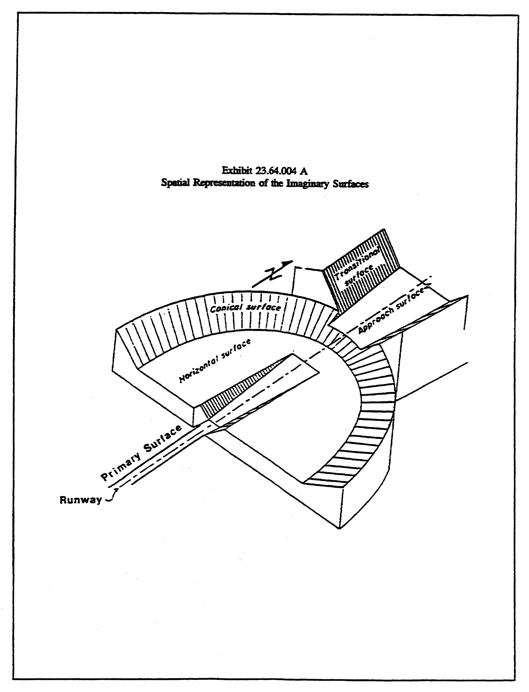
Exhibit 23.64.004B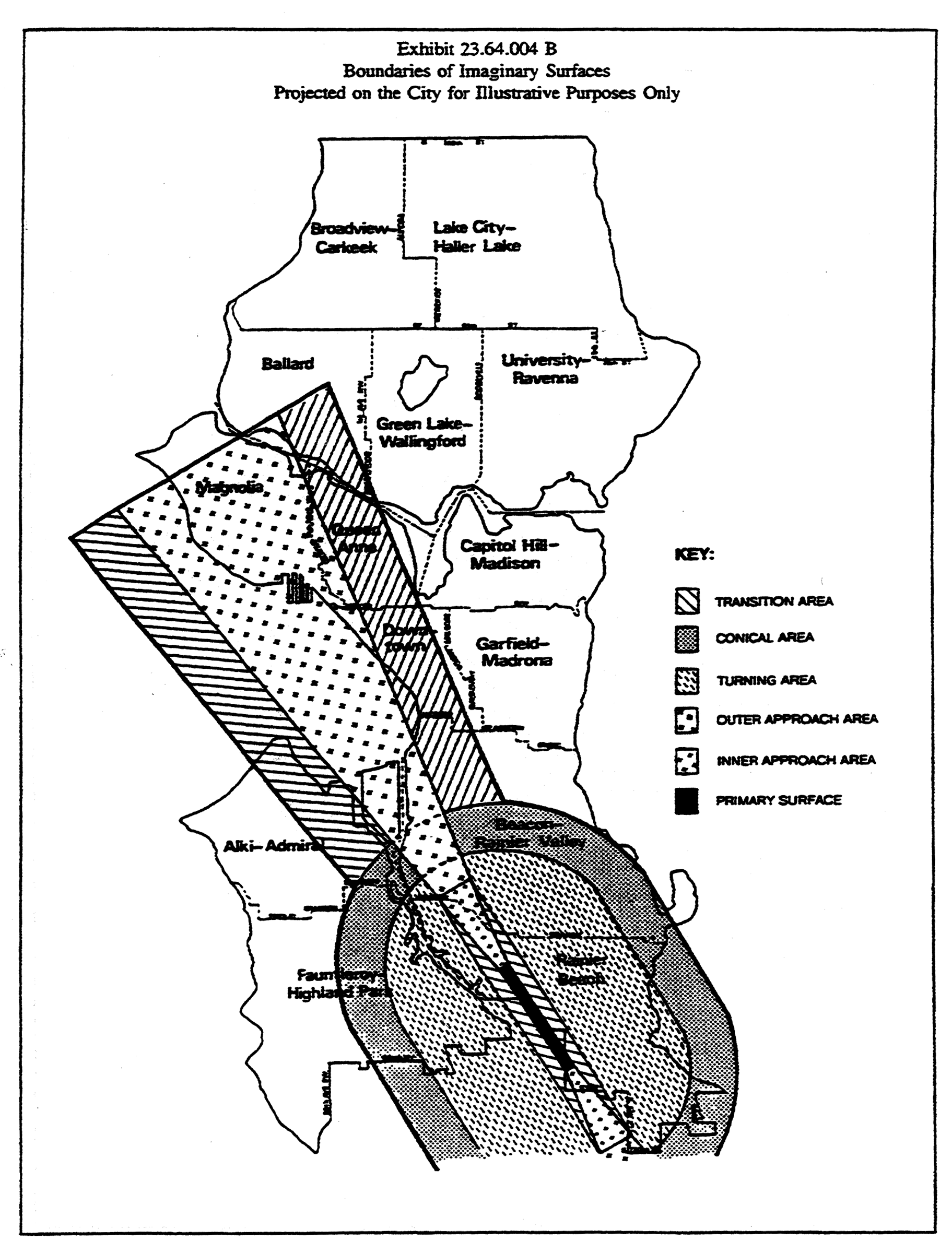
23.64.006 - Development standards.
A.
No structure shall be erected, or altered, in any area defined in this section to a height in excess of the limits established in this chapter unless otherwise provided.
B.
The maximum height permitted for structures and trees in each area shall be as follows, and shall be known as the height limits of the Airport Height Overlay District:
1.
In Inner Approach Areas (IA), the boundaries of which are shown on the Official Airport Height Map, structures and trees shall not exceed the height of the Inner Approach Surface. This shall not restrict heights in Inner Approach Areas to less than thirty-seven feet (37').
2.
In Outer Approach Areas (OA), the boundaries of which are shown on the Official Airport Height Map, structures and trees shall not exceed the height of the Outer Approach Surface.
3.
In Turning Areas (TN), the boundaries of which are shown on the Official Airport Height Map, structures and trees shall not exceed the height of the Turning Surface. This shall not restrict heights in Turning Areas to less than sixty-five feet (65').
4.
In Conical Areas (CA), the boundaries of which are shown on the Official Airport Height Map, structures and trees shall not exceed the height of the Conical Surface. This shall not restrict heights in Conical Areas to less than sixty-five feet (65').
5.
In Transition Areas (TN), the boundaries of which are shown on the Official Airport Height Map, structures and trees shall not exceed the height of the inclined Transition Surfaces. This shall not restrict heights in Transition Areas to less than thirty-seven feet (37').
C.
Trees exceeding the height limits of the Airport Height Overlay District shall not be required to be cut or trimmed to conform to the height limits of the Airport Height Overlay District unless the Director is notified by the Federal Aviation Administration (FAA) that the trees are a potential hazard to aviation.
(Ord. 114561 § 1(part), 1989.)
23.64.008 - Application of regulations.
All properties located within the Airport Height Overlay District shall be subject to both the requirements of the underlying zone classification and to the requirements imposed for the Airport Height Overlay District. At no time shall the provisions of this chapter be read to modify the provisions of the underlying zoning, other overlay districts or special districts, except for height restrictions stated in this chapter. In any case where the provisions of the Airport Height Overlay District conflict with the provisions of the underlying zone, the more restrictive height limit shall apply.
(Ord. 114561 § 1(part), 1989.)
23.64.010 - Special exception.
The Director may permit a structure to exceed the limits of the Airport Height Overlay District as a special exception pursuant to Chapter 23.76, Procedures for Master Use Permits and Council Land Use Decisions. Such an exception shall only be permitted if the Director finds that all of the following conditions exist:
A.
The Federal Aviation Administration advises the Director that the exception to the height limits does not create a hazard to aviation; and
B.
The additional height is necessary for the successful physical function of the structure; and
C.
The exception will not result in re-routing of aircraft; and
D.
The structure is designed to minimize adverse impacts of lighting on surrounding uses while complying with the lighting requirements of the Federal Aviation Administration.
(Ord. 114561 § 1(part), 1989.)