
Seattle City Zoning Code
CHAPTER 23
73 - PIKE/PINE CONSERVATION OVERLAY DISTRICT14
Editor's note— The title of Ch. 23.73 was amended by Ord. 123020, § 2, 2009.
23.73.002 - Purpose and intent
The purpose of this Chapter 23.73 is to implement Resolution 28657, calling for development of the Pike/Pine Overlay District in order to preserve and enhance the balance of residential and commercial uses, by encouraging residential development and development that combines residential and non-residential uses, while also providing additional opportunities for commercial development to balance the substantial amount of residential development that has occurred since Resolution 28657 was adopted. In addition, a purpose of this Chapter 23.73 is to promote the conservation of Pike/Pine's existing historic character by limiting new development to a scale that is compatible with the established development pattern, accommodating arts facilities and small businesses at street level, and encouraging the retention of the existing structures and their architectural features that establish the District's architectural character; generally, those structures that have been in existence prior to 1940 ("character structures"), and are related to the area's early history as Seattle's original "auto row".
(Ord. 124503, § 3, 2014; Ord. 123020, § 3, 2009; Ord. 117514 § 3 (part), 1995.)
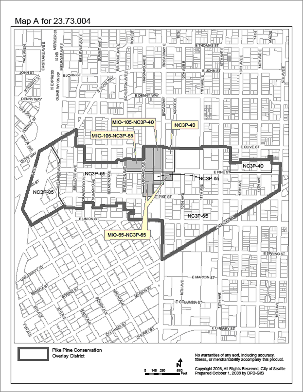
23.73.004 - Pike/Pine Conservation Overlay District established
There is hereby established pursuant to Chapter 23.59 of the Seattle Municipal Code, the Pike/Pine Conservation Overlay District as shown on the Official Land Use Map, Chapter 23.32, and Map A for 23.73.004 Pike/Pine Conservation Overlay District.
(Ord. 123020, § 4, 2009; Ord. 120004, § 5, 2000; Ord. 118414, § 55, 1996; Ord. 117514, § 3, 1995.)
23.73.005 - Adoption of rules to implement Pike/Pine Conservation Overlay District regulations
A.
The Director shall promulgate a rule, which shall be periodically updated to reflect changed conditions, listing the character structures that meet the following criteria:
1.
The structure retains a high degree of architectural integrity;
2.
The structure represents the Pike/Pine neighborhood's building typology, which is characterized by use of exterior materials and design elements such as masonry (especially brick) and timber structures; multi-use loft spaces; very high, fully-glazed storefront windows; and decorative details such as cornices, emblems and embossed building names; and
3.
The structure is compatible with the architectural scale, rhythm, and patterns of nearby structures in the Pike/Pine neighborhood.
B.
A character structure may be added to or removed from the list described in subsection 23.73.005.A by the Director in consultation with the Director of the Department of Neighborhoods.
(Ord. 124503, § 4, 2014; Ord. 123776, § 5, 2011)
23.73.006 - Application of regulations
Land that is located within the Pike/Pine Overlay District, as shown on Map A for 23.73.004, is subject to the regulations of the underlying zones unless specifically modified by the provisions of this Chapter 23.73. In the event of a conflict between the provisions of this Chapter 23.73 and the underlying zone, the provisions of this Chapter 23.73 shall apply. In the event of a conflict between the provisions of this Chapter 23.73 and Chapter 23.69, Major Institution Overlay District, the provisions of Chapter 23.69 shall apply.
(Ord. 124503, § 5, 2014; Ord. 123020, § 5, 2009; Ord. 117514 § 3 (part), 1995.)
23.73.008 - Street-level uses
A.
Street-level uses on principal pedestrian streets. Along designated principal pedestrian streets shown on Map A for 23.73.008, provisions for street-level uses are established in Chapter 23.47A, except as modified by this Section 23.73.008.
B.
Space for small commercial uses at street level
1.
Except as provided in subsection 23.73.008.B.3, all structures that include more than 5,000 square feet of commercial uses at street level, excluding the floor area of performing arts theaters, arts facilities, and parking and access, shall include commercial spaces at street level for small, individual business establishments that average 2,000 square feet or less in size, according to Table A for 23.73.008.
2.
The commercial space requirement of subsection 23.73.008.B.1 applies to the total size of a business establishment, except that if a business establishment includes more than one principal use, each principal use within the business establishment may qualify as a small business establishment.
3.
For projects that retain a character structure as provided in Section 23.73.015, in addition to any excluded floor area specified in subsection 23.73.008.B.1, floor area meeting the following conditions is not required to comply with subsection 23.73.008.B.1:
a.
The floor area is occupied by street-level commercial uses or other uses excluded from the requirement for small commercial spaces in subsection 23.73.008.B.1 and is within the original street-level footprint of the retained character structure; and
b.
The original street-level of the character structure was designed as a large space for use as automobile retail sales and service, warehouse, manufacturing, or large retail or commercial space.
c.
Original facade openings providing transparency at the street-level remain unobstructed by interior improvements to retain visual access to interior space for pedestrians on the abutting sidewalk, even if the resulting amount of transparency exceeds what is otherwise required in subsection 23.47A.008.B.2.
C.
Within new structures that face Pike, East Pike, Pine, and East Pine Streets, the length of street frontage permitted at street level for an individual business, excluding institutional uses, is limited to 50 feet. Portions of a business that are separated from the street by another business or a different use that provides separate pedestrian access to the street are not limited in width. The limit on the street frontage of an individual business does not apply to uses in an existing character structure or in a character structure retained in a project according to Section 23.73.015, provided that the original street-level of the character structure was designed as a large space for use as automobile retail sales and service, warehouse, manufacturing, or large retail or commercial space.
Map A for 23.73.008
Uses at Street Level
(Ord. 125272, § 57, 2017; Ord. 124503, § 6, 2014; Ord. 123020, § 6, 2009; Ord. 122311, § 92, 2006; Ord. 121476 § 16, 2004; Ord. 120004 § 6, 2000; Ord. 118414 § 56, 1996; Ord. 117514 § 3 (part), 1995.)
23.73.009 - Floor area
A.
For lots with residential uses only, or lots that include both residential and non-residential uses, the total FAR limit shall not exceed 3.75, except as provided in this Section 23.73.009 and in Section 23.73.024 for projects using transfer of development potential.
B.
The gross floor area of non-residential uses is limited to a maximum of 2.25 FAR, except as provided in this Section 23.73.009 and in Section 23.73.024 for projects using transfer of development potential.
C.
For development on a lot that meets one of the following conditions, the FAR limits in subsections 23.73.009.A and 23.73.009.B do not apply and the FAR limits for the underlying zone apply instead:
1.
A character structure has not existed on the lot since January 18, 2012; or
2.
For lots that include a character structure, all character structures on the lot are retained according to Section 23.73.015 or a departure is approved through the design review process to allow the removal of a character structure based on the provisions of subsection 23.41.012.B. If the lot includes a character structure that has been occupied by residential uses since January 18, 2012, the same amount of floor area in residential uses shall be retained in that structure, unless a departure is approved through the design review process to allow the removal of the character structure based on the provisions of subsection 23.41.012.B. The owner of the lot shall execute and record in the King County real property records an agreement to provide for the maintenance of the required residential uses for the life of the project.
D.
In addition to the floor area exempt under the provisions of the underlying zone, the following floor area is exempt from the calculation of gross floor area subject to an FAR limit if a character structure is retained on the lot:
1.
The following street-level uses complying with the standards of Section 23.47A.008 and subsection 23.73.008.B:
a.
General sales and services;
b.
Major durables retail sales;
c.
Eating and drinking establishments;
d.
Museums;
e.
Religious facilities;
f.
Libraries; and
g.
Automotive retail sales and service uses located within an existing structure or within a structure that retains a character structure as provided in Section 23.73.015.
2.
Floor area used for theaters or arts facilities.
3.
All floor area in residential use in a development that retains all character structures on the lot as provided in Section 23.73.015, or that uses the transfer of development potential (TDP) on a lot that is a TDP receiving site according to Section 23.73.024, unless a departure is approved through the design review process to allow the removal of a character structure based on the provisions of subsection 23.41.012.B.
4.
In areas where the underlying zoning is NC3P-75, all floor area in any use if the lot that is to be developed is 8,000 square feet or less in area and has been either vacant or in parking use since February 27, 1995.
5.
Floor area in non-residential use within a character structure that meets the minimum requirements for retaining a character structure in subsection 23.73.024.C.4, provided that the non-residential use does not displace a residential use existing in the structure since January 18, 2012.
(Ord. 126157, § 50, 2020; Ord. 125791, § 102, 2019; Ord. 125429, § 17, 2017; Ord. 125272, § 58, 2017; Ord. 124503, § 7, 2014; Ord. 123776, § 6, 2011; Ord. 123020, § 7, 2009)
23.73.010 - Floor area limits outside the Conservation Core
A.
Floor area limit. The following provisions apply to lots located outside the boundaries of the Conservation Core identified on Map A for 23.73.010.
1.
The maximum gross floor area of any single story above 35 feet in height is limited to 15,000 square feet, except as provided in subsections 23.73.010.A.2, 23.73.010.A.3, 23.73.010.B, and 23.73.010.C.
2.
For a project that is allowed extra height above the height limit by subsection 23.73.014.A, the 35-foot height above which the floor area limit applies is increased to 39 feet, provided that the provisions for allowing additional height under subsection 23.73.014.A are met.
3.
For a project that is allowed extra height above the height limit by subsection 23.73.014.B, the 35-foot height above which the floor area limit applies is increased to 39 feet, provided that:
a.
The provisions for allowing additional height under subsection 23.73.014.B are met, and
b.
The minimum floor-to-ceiling height of non-residential uses at street level is at least 13 feet, except that if a character structure is retained according to Section 23.73.015, the floor-to-ceiling height of the portion of the street-level story above the footprint of the character structure need not exceed the original floor-to-ceiling height of the character structure.
4.
On a lot with more than one structure or more than one portion of the same structure that exceeds 35 feet in height, the floor area limit applies to the combined portions of each story above 35 feet in height. If 39 feet is the height above which the floor area limit applies as allowed by subsection 23.73.010.A.1 and subsection 23.73.010.A.2, then the floor area limit applies to the combined portions of each story above 39 feet.
5.
If new structures on the same or abutting lots have internal connections above or below grade, each of the stories of the connected structures are considered to be a single story for the purpose of calculating the floor area subject to the floor area limit.
Map A for 23.73.010 Conservation Core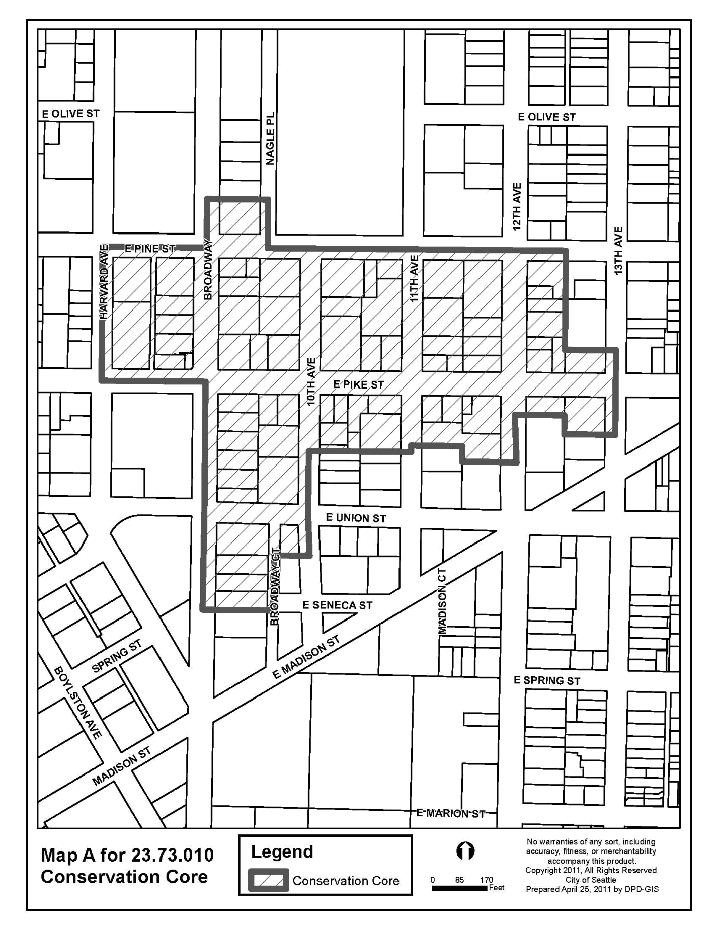
B.
Exceptions to floor area limit
1.
A 15 percent increase in the floor area limit is permitted for projects that meet the following conditions:
a.
The project retains all the character structures existing on the lot, unless a departure is approved through the design review process to allow the removal of a character structure based on the provisions of subsection 23.41.012.B; and
b.
The project includes uses that contribute to the area's recognized character as an arts district, including performing arts space or artist-studio dwellings that typically have design requirements such as nonstandard floor-to-ceiling heights that reduce the total amount of usable floor area in a structure; or
c.
A minimum of 50 percent of the total gross floor area of the project is moderate-income units; or
d.
Through the design review process a determination is made that including one or more of the following features offsets the increase in the bulk of the project and allows for a design treatment that achieves the intent of the neighborhood design guidelines better than adhering to the floor area limit that would apply without the exception:
1)
A landscaped courtyard that is visible from the sidewalk and located primarily at street level on a street that is not a principal pedestrian street;
2)
A through-block pedestrian corridor that connects parallel streets bounding the project, consistent with the neighborhood design guidelines; or
3)
Open space at locations that support the gateway and open space concepts promoted in the neighborhood design guidelines.
2.
Retaining character structures on a lot. A 25 percent increase in the floor area limit established in subsection 23.73.010.A is permitted for a project that retains all the character structures on the same lot according to the provisions in Section 23.73.015, unless a departure is approved through the design review process to allow the removal of a character structure based on the provisions of subsection 23.41.012.B. Any increase in floor area permitted according to this subsection 23.73.010.B.2 shall not be combined with any other increase in floor area permitted according to subsection 23.73.010.B.1 or 23.73.010.B.3.
3.
A 25 percent increase in the floor area limit is permitted on a lot that qualifies as a receiving site for a project that adds floor area through the use of TDP as permitted by Section 23.73.024, provided that the amount of floor area added through the use of TDP is equivalent to at least 0.25 FAR, as calculated for the receiving site. Any increase in floor area permitted according to this subsection 23.73.010.B.3 shall not be combined with any other increase in floor area permitted according to subsection 23.73.010.B.1 or 23.73.010.B.2.
C.
Exempt floor area. The following is not included in calculating floor area subject to the floor area limit:
1.
Floor area within an existing character structure either on the lot or an abutting lot within the same development site if the entire character structure is retained according to the provisions of subsection 23.73.024.C.4.
2.
For a project that retains an entire character structure on the lot according to the requirements of subsection 23.73.024.C.4, any floor area in a portion of the new structure that extends or cantilevers over the character structure; provided that the new structure does not alter the envelope or interior of the character structure. Connections between the new structure and the facades of the retained character structure that do not face a public street are allowed.
(Ord. 126855, § 63, 2023; Ord. 125791, § 103, 2019; Ord. 125429, § 18, 2017; Ord. 124503, § 8, 2014; Ord. 123776, § 7, 2011; Ord. 123392, § 5, 2010; Ord. 123020, § 8, 2009; Ord. 122311, § 93, 2006; Ord. 121196 § 28, 2003; Ord. 120004 § 7, 2000.)
23.73.012 - Structure width and depth limits
A.
Structure width limit outside the Conservation Core. Outside the Conservation Core identified on Map A for 23.73.010, for all portions of a structure that abut Pike, East Pike, Pine, or East Pine Streets, structure width shall be limited to 50 percent of the total width of all lots on the block front, measured along the street lot line, on block fronts that exceed 170 feet in width, except that the structure width limit calculation does not include the following:
1.
Portions of a character structure that are retained according to the provisions in Section 23.73.015, whether connected to a new structure or not;
2.
Portions of a new structure that are separated from the street lot line by another lot;
3.
Portions of a new structure that are separated from the street lot line by an adjacent structure located on the same lot that is not a character structure, provided that the adjacent structures are not internally connected above or below grade; and
4.
Portions of a new structure that are separated from the street lot line by a character structure that is retained according to the provisions of Section 23.73.015.
B.
Structure width and depth limits inside the Conservation Core. The structure width and depth limits in this subsection 23.73.012.B apply to lots that are located inside the Conservation Core identified on Map A for 23.73.010, except that there are no limits on width and depth for lots that did not contain a character structure on January 18, 2012.
1.
128 feet shall be the width and the depth limit for portions of new structures on lots that contained a character structure on January 18, 2012. The width limit is measured as the combined width of all portions of new structures located on the lot and the depth limit is measured as the combined depth of all portions of new structures located on the lot, except as provided in subsection 23.73.012.B.2 and subsection 23.73.012.B.3.
2.
Portions of a new structure that are separated from the street lot line by a character structure that is retained according to Section 23.73.015 are excluded from structure width and depth measurements, provided that:
a.
All character structures on the lot are retained according to the provisions of Section 23.73.015, unless a departure is approved through the design review process to allow the removal of a character structure based on the provisions of subsection 23.41.012.B; and
b.
This exclusion from width and depth measurement in subsection 23.73.012.B.2 is only allowed for one retained character structure on the lot.
3.
For the narrow block bounded by Broadway, East Union Street, Broadway Court, and East Madison Street, the depth limit does not apply to structures on through lots extending from Broadway to Broadway Court, and the width limit only applies to frontages on Broadway and Broadway Court.
(Ord. 126157, § 51, 2020; Ord. 125429, § 19, 2017; Ord. 124503, § 9, 2014; Ord. 123776, § 8, 2011)
23.73.014 - Height exceptions
A.
Height exception for street-level uses. In zones with a mapped height limit of 75 feet, an additional 4 feet of height above the height limit of the zone is allowed for structures that include uses listed as required street-level uses in subsection 23.47A.005.D.1 or live-work use if the following conditions are met:
1.
The floor-to-ceiling height of the street-level uses or live-work units located at street level is 13 feet or more, except when a character structure is retained according to Section 23.73.015, the floor-to-ceiling height of the portion of the street-level story above the footprint of the character structure need not exceed the original floor-to-ceiling height of the character structure;
2.
The additional height will not permit an additional story to be built beyond the number that could be built under a 75-foot height limit; and
3.
The transparency requirements for street-facing facades in subsection 23.47A.008.B.2 are met for the portion of the street-facing facades between 2 feet and 12 feet above the sidewalk. Only clear or lightly-tinted glass shall be considered transparent. For a character structure that is retained in a new project according to Section 23.73.015, measurement for required transparency of the street-facing facades of the character structure shall be according to the provisions of subsection 23.86.026.B.
B.
Height exception for lots that include a character structure. In zones with a 75-foot mapped height limit, 10 feet of additional height is allowed above the 75-foot height limit if the following requirements are met:
1.
The lot includes a character structure and all character structures on the lot are retained according to the provisions of Section 23.73.015, unless a departure is approved through the design review process to allow removal of a character structure based on the provisions of subsection 23.41.012.B;
2.
The additional floor area above the 75-foot height limit is occupied solely by residential use, except as otherwise permitted by subsection 23.73.014.B.3; and
3.
In a project that is permitted the FAR of the underlying zone for non-residential uses under subsection 23.73.009.C, additional floor area permitted above the 75-foot height limit under this subsection 23.73.014.B may be occupied by non-residential uses if a departure is approved through the design review process, provided that there is no additional increase in the FAR for non-residential uses beyond what is otherwise allowed by Section 23.73.009. The decision to allow a departure shall be based on a determination that the additional height will result in a better design treatment and accommodate features that promote the development objectives of the Pike/Pine Conservation Overlay District by:
a.
Maintaining greater portions of existing character structures on the lot through design treatments that exceed the minimum standards of subsection 23.73.015.A, retaining an entire character structure, or retaining a large number of character structures if the number and siting of the structures pose severe limitations on the amount of floor area that can be achieved in the new project within the applicable height limit; or
b.
Providing space for features that enhance pedestrian circulation and walkability in the area, such as through-block pedestrian corridors, or open spaces at locations that support the gateway and open space concepts promoted in the neighborhood design guidelines; or
c.
Accommodating uses, such as theater space or arts facilities that support the area's arts and culture function but that may have special spatial needs that require additional design flexibility to incorporate them into the project, provided the uses are maintained for the life of the project as provided for in a recorded covenant approved by the Director.
C.
Height exception for character structure TDP receiving sites. A height exception for character structure TDP receiving sites is allowed according to subsection 23.73.024.B.
D.
If a project uses more than one of the height exceptions permitted by this Section 23.73.014, the maximum height shall be the height permitted by the exception allowing the greatest height increase.
E.
Additional height for rooftop features. For structures using the height exceptions specified in this Section 23.73.014, additional height is permitted above the maximum height allowed by the exception to accommodate rooftop features as permitted under subsection 23.47A.012.C.
(Ord. 125791, § 104, 2019; Ord. 125429, § 20, 2017; Ord. 125272, § 59, 2017; Ord. 124503, § 10, 2014; Ord. 123776, § 9, 2011)
23.73.015 - Retention and demolition of character structures
A.
For provisions in this Chapter 23.73 that require a portion of a character structure to be retained in order to earn incentives, in addition to the provisions of the applicable section, the minimum requirements for retaining a character structure are as follows:
1.
All street-facing facades of the character structure shall be maintained for the life of the project, and original facade openings that provide transparency at the street-level shall remain unobstructed to retain visual access to interior spaces for pedestrians on the abutting sidewalk, even if the resulting amount of transparency exceeds what is otherwise required in subsection 23.47A.008.B.2;
2.
All portions of the new structure above the height of the street-facing facades of the character structure shall be set back a minimum of 15 feet from the street-facing facades of the character structure, except:
a.
Projections such as unenclosed balconies, bay windows, cornices, belt courses; and eaves, gutters, and other forms of weather protection may project a maximum of 18 inches into the required setback; and
b.
On through lots that are bounded on three or more sides by a street and that are less than 170 feet wide measured between streets, a setback is not required from the narrowest abutting street that is not shown as a Principal Pedestrian Street on Map A for 23.73.008.
3.
The original floor-to-ceiling height of the street-level story of the character structure is maintained, allowing for adjustments to provide access to persons with disabilities.
4.
If it is determined at any time that the character structure's street-facing facade cannot be maintained as required under subsection 23.73.015.A.1, the Design Review Board shall review any proposed changes to the facade before changes are made. If the proposed facade changes are not approved through the design review process the incentives may not be used.
B.
Character structures that are retained as provided by this Section 23.73.015 shall be maintained as approved by the Master Use Permit for the project for the life of the project in a manner that complies with applicable codes and approved plans, including the approved plan required by subsection 23.73.015.C.
C.
The applicant, as part of the Master Use Permit application submittal, shall submit the following:
1.
A plan specifying the portions of the character structure to be retained, demolished, or rebuilt. For portions of the structure to be retained, the plan shall clearly indicate: the materials to be retained in place, salvaged for reconstruction, or otherwise modified, and new materials to be used in any reconstruction; and
2.
A representation of the structure's final appearance.
D.
A demolition permit may only be approved for portions of the project that are specified for demolition in the plan submitted with the Master Use Permit application.
E.
For the purposes of applying any applicable street-level developments standards of Section 23.47A.008, the portion of a character structure that is retained to meet the standards of subsection 23.73.015.A shall be regarded as an existing structure.
F.
Departure from standards for retaining portions of a character structure. For a project that retains portions of a character structure, departures from the provisions in subsection 23.73.015.A may be granted through the design review process, provided that one or more of the following conditions apply:
1.
The departure will allow for design treatments that reduce the appearance of the bulk of the new structure and enhance the relationship between the new structure and the retained character structure on the lot or development on adjacent lots; or
2.
The portions of the new structure will not obscure key elements of the retained structure's architectural character; or
3.
The departure will facilitate the retention of other character structures on the lot; or
4.
Additional flexibility is necessary to maintain a character structure on a development lot that is constrained by size or configuration; or
5.
The departure will allow for a more functional street-level plan and improved pedestrian access while retaining key qualities of the street-level story of the character structure, especially as perceived from the street.
G.
Demolition of character structures. If a project is required to retain all the character structures on a lot under the provisions of this Chapter 23.73, a character structure may nevertheless be demolished through a departure approved by the design review process according to the provisions of subsection 23.41.012.B.
(Ord. 125429, § 21, 2017; Ord. 125272, § 60, 2017; Ord. 124503, § 11, 2014)
23.73.016 - Amenity area
A.
Amenity area is not required for structures existing as of April 1, 2000, that are repaired, renovated, or structurally altered to the extent permitted by the development standards of the Land Use Code, provided that street-facing facades are retained and 50 percent or more of the gross floor area is retained.
B.
Amenity area is not required for low-income housing.
C.
Amenity area in existing low-income housing may be removed.
(Ord. 126855, § 64, 2023; Ord. 123776, § 10, 2011)
23.73.018 - Location of Parking
Parking provided as accessory parking for any permitted use may be located on the lot, or built into or under the structure, or located on a lot other than the lot on which the use is located except that parking is not permitted on a lot other than the lot where the use is located if providing the parking would result in the partial or total demolition of a character structure.
(Ord. 123776, § 11, 2011)
23.73.024 - Transfer of development potential
A.
General standards for the transfer of development potential (TDP) within the Pike/Pine Conservation Overlay District
1.
For a lot located in an NC3P-75 zone within the Pike/Pine Conservation Overlay District shown on Map A for 23.73.004, an applicant may use TDP to obtain any of the following:
a.
A floor area exemption for residential and live-work unit floor area, as permitted under subsection 23.73.009.D.3;
b.
A height exception to allow an additional 10 feet above the 75-foot height limit; and
c.
A 25 percent increase in the floor area limit as provided in subsection 23.73.010.B.3.
2.
Within the Conservation Core shown on Map A for 23.73.010, a lot that is an eligible sending site meeting the provisions of subsection 23.73.024.C may transfer development potential to any lot that is an eligible receiving site meeting the provisions of subsection 23.73.024.B. Eligible receiving sites may only gain development potential from eligible sending sites that are also located within the Conservation Core.
3.
Development potential may not be transferred from one lot to another except as allowed by this Chapter 23.73.
4.
Development potential may be transferred from eligible sending sites meeting the provisions of subsection 23.73.024.C to locations outside the Pike/Pine Conservation Overlay District if TDP transfer to specifically identified areas or lots is authorized by City ordinance.
B.
Standards for character structure TDP receiving sites. A lot must meet the following conditions in order to be eligible to achieve extra residential floor area through TDP:
1.
TDP receiving sites shall be located in an NC3P-75 zone within the Pike/Pine Conservation Overlay District, provided that:
a.
Development of the receiving site shall not result in the demolition of a structure designated as a Landmark according to Chapter 25.12 or its alteration in a manner that is inconsistent with Chapter 25.12 or an ordinance imposing controls on the Landmark structure.
b.
Development on the lot that is the receiving site shall not result in the demolition or significant alteration of a character structure that is not a designated Landmark and that has existed on the site since January 18, 2012, unless a departure is approved through the design review process to allow the removal of a character structure based on the provisions of subsection 23.41.012.B. For the purposes of this subsection 23.73.024.B.1.b, significant alterations to a character structure would result in conditions that would preclude compliance with the minimum requirements of subsection 23.73.024.C.4.
2.
An additional 10 feet in height above the height limit of the zone is permitted on a lot that is an eligible TDP receiving site.
3.
Any residential and live-work floor area that is exempt from the FAR limit as allowed by subsection 23.73.009.D.3, or any floor area that exceeds the maximum floor area limit as allowed under subsection 23.73.010.B.3, or that is located above 75 feet in height shall be achieved through the use of TDP.
4.
Floor area gained through the use of TDP shall be for residential and live-work unit use only.
5.
For a structure that achieves an increase in height through the use of TDP, the minimum street-level floor-to-ceiling height is 13 feet.
6.
TDP required before construction. No permit after the first building permit, and in any event no permit for construction activity other than excavating or shoring, and no permit for occupying existing floor area by any use based on TDP; will be issued for development that includes TDP until the applicant has demonstrated possession of TDP to the Director's satisfaction.
C.
Standards for sending sites. A lot must meet the following conditions in order to be eligible as a sending site to transfer extra residential floor area through TDP to a lot that is an eligible receiving site according to subsection 23.73.024.B:
1.
TDP sending sites shall be located in an NC3P zone within the Pike/Pine Conservation Overlay District, excluding NC3P zones with an MIO-105 overlay, and shall contain one of the following structures:
a.
One or more structures designated wholly or in part as a landmark under Chapter 25.12 or its predecessor ordinance; or
b.
Any character structure, provided that character structures on the proposed TDP sending site have not been demolished or significantly altered since January 18, 2012, unless a departure is approved through the design review process to allow the removal of a character structure based on the provisions of subsection 23.41.012.B.33. For the purposes of this subsection 23.73.024.C.1.b, a significant alteration results in conditions that would preclude the character structure from complying with the minimum requirements for retaining the character structure in subsection 23.73.024.C.4.
2.
Maximum transferable floor area
a.
The maximum amount of floor area that may be transferred from an eligible sending site with a character structure that is not a designated landmark is the product of: the eligible lot area of the sending site, times the maximum FAR for structures containing both residential and non-residential uses as prescribed in Section 23.47A.013, minus the sum of any chargeable gross floor area on the sending site under the zoning in effect at the time a complete application transferring TDP is accepted, and minus any TDP previously transferred from the sending site.
b.
The maximum amount of floor area that may be transferred from an eligible sending site with a designated landmark is the amount calculated in subsection 23.73.024.C.2.a multiplied by two.
c.
For purposes of this subsection 23.73.024.C.2, the eligible sending site lot area is the total area of the lot where the character structure was originally built.
3.
Rehabilitation and maintenance of character structures. Character structures that are designated landmark structures on sending lots from which TDP is transferred shall be rehabilitated and maintained as required by the Landmarks Preservation Board. Character structures located on a lot that is a TDP sending site that are not designated landmark structures shall be rehabilitated and maintained to comply with applicable codes and shall remain in compliance with the provisions of subsection 23.73.024.C.4 for the life of the structure on the receiving site that includes the additional gross floor area. If the TDP is proposed to be transferred prior to completing rehabilitation work necessary to satisfy this subsection 23.73.024.C, the Director may require as a condition of the transfer that a security be deposited with the City in an amount determined by the Director to ensure that the work is completed.
4.
For character structures that are not designated landmark structures, the following provisions for retaining the character structure shall apply:
a.
All exterior facades are retained; except that portions of a new structure may abut facades that are not street-facing facades, and connections between the new structure and the facades of the retained character structure that do not face a public street are allowed; and
b.
The original floor area of the character structure is maintained, except that additions or alterations that extend the useful physical life or economic viability of the structure are permitted, provided that:
1)
The additions do not significantly damage or destroy the structural system of the character structure or fundamentally alter historic characteristics of its exterior appearance; and
2)
The total floor area of any additions, excluding floor area added to reclaim floor area that may have been removed from the original structure over time, does not exceed the equivalent of 0.5 FAR, as calculated on the lot where the structure was originally built.
D.
TDP deeds and agreements
1.
The fee owners of the TDP sending site shall execute a deed, and shall obtain the release of the TDP from all liens of record and the written consent of all holders of encumbrances on the sending lot other than easements and restrictions, unless the requirement for a release or consent is waived by the Director for good cause. The deed shall be recorded in the King County real property records. If TDP is conveyed to the owner of a TDP receiving site described in the deed, then unless otherwise expressly stated in the deed or any subsequent instrument conveying the lot or the TDP, the TDP shall pass with the receiving site whether or not a structure using the TDP shall have been permitted or built prior to any conveyance of the receiving site. Any subsequent conveyance of TDP previously conveyed to a receiving site shall require the written consent of all parties holding any interest in or lien on the receiving site from which the conveyance is made. If the TDP is transferred other than directly from the sending site to the receiving site using the TDP; then after the initial transfer all subsequent transfers shall also be by deed, duly executed, acknowledged, and recorded, each deed referring by King County recording number to the prior deed.
2.
Any person may purchase TDP that is eligible for transfer by complying with this Section 23.73.024, whether or not the purchaser is a permit applicant to develop real property or the owner of potential receiving site. Any TDP purchaser, including any successor or assignee, may use TDP on a receiving site to the extent that using TDP is permitted under the Land Use Code provisions applicable at the time the project intended to use the TDP vests, according to Section 23.76.026. The Director may require, as a condition of processing any permit application using TDP, that the owner of the receiving site demonstrate that the TDP has been validly transferred of record to the receiving site, and that the receiving site owner has recorded in the real estate records a notice stating that a permit application using TDP has been filed and the TDP to be used on the receiving site is not available for retransfer.
3.
As a condition to the effective transfer of TDP from a designated landmark, except from a City-owned sending site, the fee owner of the sending site shall execute and record an agreement running with the land, in form and content acceptable to, and accepted in writing by, the Director of Neighborhoods; providing for the rehabilitation and maintenance of the historically-significant or other relevant features of the structure or structures on the lot and acknowledging the restrictions on future development resulting from the transfer. The Director may require evidence that each lien holder has effectively subordinated the lien to the terms of the agreement, and that any holders of interests in the property have agreed to its terms. To the extent that a landmark structure on the sending site, the presence of which is a condition to eligibility to transfer TDP under the provisions of the zone, requires restoration or rehabilitation for the long-term preservation of the structure or its historically or architecturally-significant features, the Director of Neighborhoods may require as a condition to acceptance of the necessary agreement that the owner of the sending site apply for and obtain a certificate of approval from the Landmarks Preservation Board for the necessary work, or post security satisfactory to the Director of Neighborhoods for the completing the restoration or rehabilitation.
E.
Reservation in deed. Any TDP eligible for transfer may instead be reserved in the conveyance of title to an eligible sending site by the express terms of the deed or other instrument of conveyance reserving a specified amount of TDP, provided that an instrument acceptable to the Director is recorded binding the sending site to the terms and conditions for eligibility to send TDP under this Section 23.73.024. Any TDP so reserved shall be considered transferred from that site and later may be conveyed by deed without participation of the owner of the site.
F.
Any agreement governing the use or development of the sending site shall provide that its covenants or conditions run with the land and shall be specifically enforceable by the City.
G.
The eligibility of a sending site to transfer TDP and the amount transferable from a sending site, shall be determined as of the date of transfer from the sending site and shall not be affected by the date of any application, permit decision, or other action for any project seeking to use TDP.
(Ord. 125791, § 105, 2019; Ord. 125603, § 66, 2018; Ord. 125429, § 22, 2017; Ord. 124503, § 12, 2014; Ord. 123776, § 12, 2011)