
Seattle City Zoning Code
CHAPTER 23
66 - SPECIAL REVIEW DISTRICTS
Subchapter II - Pioneer Square Preservation District
Part 1 General Purpose and Organization
Subchapter III - International Special Review District
Part 1 General Purposes and Organization
23.66.010 - Establishment of special review districts.
The Council may establish special review districts by ordinance to control development in such districts.
(Ord. 112134 § 1(part), 1985.)
23.66.015 - Procedure to establish, alter or abolish special review districts.
A petition to establish, alter or abolish a special review district shall be filed and considered in the same manner as amendments to the Official Land Use Map, Chapter 23.32. A petition or proposal to establish a special review district shall include a statement of purpose. The boundaries of a special review district shall be drawn on the Official Land Use Map.
(Ord. 112134 § 1(part), 1985.)
23.66.018 - Director of the Department of Neighborhoods
As used in this chapter, "Director of Neighborhoods", "Department of Neighborhoods Director" and "Director of the Department of Neighborhoods" mean the Director of the department or the Director's designee.
(Ord. 123589, § 75, 2011; Ord. 118012 § 18A, 1996)
23.66.020 - Special review boards
A.
The ordinance establishing a special review district may create a special review board. Unless otherwise specified, a special review board shall consist of seven members. Five of the members shall be chosen at annual elections, called and conducted by the Department of Neighborhoods Director, at which all residents, persons who operate businesses, their employees, and property owners of the special review district shall be eligible to vote. Two of the members shall be appointed by the Mayor and confirmed by the Council. The Mayor shall, in making board appointments, attempt to assure that a diversity of interests in the district is represented on the board. The Department of Neighborhoods Director shall provide 20 days' notice of the board's first meeting in the City's official newspaper, by Land Use Information Bulletin, and by publishing notice in one or more community newspapers that are circulated within the district. Thereafter, notice of annual meetings shall be provided to the public by the board's publication of notice in one or more district community newspapers. The Council shall establish terms of service for members of a special review board in the ordinance creating the district. No person shall serve more than two consecutive terms on a special review board.
B.
Each special review board shall elect a chairperson and adopt procedures as required to conduct its business. Staff assistance to each special review board shall be provided by the Department of Neighborhoods Director. A majority of all members of the special review board shall constitute a quorum for the purpose of transacting business. All decisions shall be by majority vote of those members present. In the event of a tie vote, a motion shall be defeated. The special review board shall keep minutes of all of its official meetings which shall be maintained by the Department of Neighborhoods Director. The Department of Neighborhoods Director shall also maintain a copy of the procedures of the special review board.
C.
When use and development standards for a special review district are not provided in the ordinance creating the district, the special review board shall recommend such standards pursuant to Section 23.66.025 of this chapter.
D.
The special review board shall review applications for certificates of approval, including departures from land use code requirements, and all petitions or applications for amendments to the Official Land Use Map, conditional uses, special exceptions, variances, and planned unit developments or planned community developments and shall make a recommendation on any such application or petition to the Department of Neighborhoods Director.
E.
The special review board may, in its discretion, make recommendations to the Mayor, the Council, and any public or private agency concerning land use and development in the district.
(Ord. 125429, § 15, 2017; Ord. 124843, § 52, 2015; Ord. 121477, § 42, 2004; Ord. 116744, § 29, 1993; Ord. 112134, § 1(part), 1985.)
23.66.025 - Use and development standards.
A.
The Council may include use and development standards in the ordinance establishing a special review district. If use and development standards are not included, the special review board may, after at least one (1) public hearing, recommend use and development standards for the special review district to the Department of Neighborhoods Director who shall recommend use and development standards to the Council. If the special review board fails to recommend use and development standards within ninety (90) days after its first meeting, the Department of Neighborhoods Director shall prepare use and development standards and recommend such standards to the Council. The Council shall consider proposed use and development standards in the same manner as Land Use Code text amendments. Use and development standards shall be adopted by ordinance and may thereafter be amended in the same manner as Land Use Code text amendments as provided in Chapter 23.76.
B.
The use and development standards shall identify the unique characteristics of the district, shall include a statement of purpose and intent, and shall be consistent with the purposes for creating the special review district. The standards shall identify uses, structures and design features that have positive or negative effects upon the character of the district, and may modify use and development standards and other provisions of the Land Use Code to allow and encourage or to limit or exclude structures, designs, and uses. All provisions of the Land Use Code shall apply in special review districts. Use and development standards shall specify the criteria by which uses, structures and designs will be evaluated. In the event of irreconcilable differences between the use and development standards adopted pursuant to this chapter, and the provisions regulating the underlying zone, the provisions of this chapter shall apply.
C.
The Department of Neighborhoods Director, following recommendation by the board, may adopt rules consistent with the use and development standards of the special review district, in accordance with Chapter 3.02 of the Seattle Municipal Code.
(Ord. 118414 § 46, 1996; Ord. 116744 § 30, 1993; Ord. 112134 § 1(part), 1985.)
23.66.030 - Certificates of approval—Application, review and appeals
A.
Certificate of approval required. No person shall alter, demolish, construct, reconstruct, restore, remodel, make any visible change to the exterior appearance of any structure, or to the public rights-of-way or other public spaces in a special review district, and no one shall remove or substantially alter any existing sign or erect or place any new sign or change the principal use of any building, or any portion of a building, structure or lot in a special review district, and no permit for such activity shall be issued unless a certificate of approval has been issued by the Department of Neighborhoods Director.
B.
Fees. The fees for certificates of approval shall be established in accordance with the requirements of Section 22.900G.010.
C.
Application
1.
An application for a certificate of approval shall be filed with the Director of the Department of Neighborhoods. When a permit application is filed with the Director or with the Director of Transportation for work requiring a certificate of approval, the permit application shall not be determined to be complete until the applicant has submitted a complete application for a certificate of approval to the Department of Neighborhoods.
2.
The following information must be provided in order for the application to be complete, unless the Director of the Department of Neighborhoods indicates in writing that specific information is not necessary for a particular application:
a.
Building name and building address;
b.
Name of the business(es) located at the site of the proposed work;
c.
Applicant's name and address;
d.
Building owner's name and address;
e.
Applicant's telephone number;
f.
The building owner's signature on the application, or a signed letter from the owner designating the applicant as the owner's representative, if the applicant is not the owner;
g.
Confirmation that the fee required by Section 22.900G.010 has been paid;
h.
A detailed description of the proposed work, including:
1)
Any changes that will be made to the building or the site,
2)
Any effect that the work would have on the public right-of-way or other public spaces,
3)
Any new construction,
4)
Any proposed use, change of use, or expansion of use;
i.
Four sets of scale drawings, with all dimensions shown, of:
1)
A site plan of existing conditions, showing adjacent streets and buildings, and, if the proposal includes any work in the public right-of-way, the existing street uses, such as street trees and sidewalk displays, and another site plan showing proposed changes to the existing conditions,
2)
A floor plan showing the existing features and a floor plan showing the proposed new features,
3)
Elevations and sections of both the proposed new features and the existing features,
4)
Construction details,
5)
A landscape plan showing existing features and plantings, and another landscape plan showing proposed site features and plantings;
j.
Photographs of any existing features that would be altered and photographs showing the context of those features, such as the building facade where they are located;
k.
One sample of proposed colors, if the proposal includes new finishes or paint, and an elevation drawing or a photograph showing the location of proposed new finishes or paint;
l.
If the proposal includes new signage, awnings, or exterior lighting:
1)
Four sets of scale drawings of proposed signage or awnings, showing the overall dimensions, material, design graphics, typeface, letter size, and colors,
(2)
Four sets of a plan, photograph, or elevation drawing showing the location of the proposed awning, sign, or lighting,
3)
Four copies of details showing the proposed method of attaching the new awning, sign, or lighting,
4)
The wattage and specifications of the proposed lighting, and a drawing or picture of the lighting fixture,
5)
One sample of proposed sign colors or awning material and color,
6)
For new signage or awnings in the International Special Review District, the dimensions of the street frontage on the side where the sign or awning would be located;
m.
If the proposal includes demolition of a structure or object:
1)
A statement of the reason(s) for demolition,
2)
A description of the replacement structure or object and the replacement use;
n.
If the proposal includes replacement, removal, or demolition of existing features, a survey of the existing conditions of the features that would be replaced, removed, or demolished.
3.
The Director of the Department of Neighborhoods shall determine whether an application is complete and shall notify the applicant in writing within twenty-eight (28) days of the application being filed whether the application is complete or that the application is incomplete and what additional information is required before the application will be complete. Within fourteen (14) days of receiving the additional information, the Director of the Department of Neighborhoods shall notify the applicant in writing whether the application is now complete or what additional information is necessary. An application shall be deemed to be complete if the Director of the Department of Neighborhoods does not notify the applicant in writing by the deadlines in this section that the application is incomplete. A determination that the application is complete is not a determination that the application is vested.
4.
The determination of completeness does not preclude the Director of the Department of Neighborhoods or the board from requiring additional information during the review process if more information is needed to evaluate the application according to the criteria in this chapter and in any rules adopted by the board, or if the proposed work changes. For example, additional information that may be required could include a shadow study or a traffic study when new construction is proposed.
5.
An applicant may make a written request to submit an application for a certificate of approval for a preliminary design of a project if the applicant waives in writing the deadline for a board recommendation and decision by the Director of the Department of Neighborhoods on the subsequent design phase or phases of the project, and agrees in writing that the decision by the Director of the Department of Neighborhoods on the preliminary design is immediately appealable by the applicant or any interested person. The staff may reject the request if it appears that approval of a preliminary design would not be an efficient use of staff or board time and resources, or would not further the goals and objectives of this chapter. To be complete, an application for a certificate of approval for a preliminary design must include the information listed above in subsection C2, subparagraphs a through h, i(1) through i(3), j, m and n. A certificate of approval that is granted for a preliminary design shall be conditioned upon subsequent submittal of the final design and all of the information listed above in subsection C2, and upon board approval, prior to issuance of permits for work affecting the structure, right-of-way or space.
6.
After the special review board has given notice of the meeting at which an application for a certificate of approval will be considered, no other application for the same alteration or change of use may be submitted until the application is withdrawn or the Department of Neighborhoods Director has approved or denied the existing application and all appeals have been concluded, except that an application may be made for a certificate of approval for the preliminary design of a project and a later application made for a certificate of approval for a subsequent design phase or phases of the same project.
D.
Review
1.
Review when no special review board is established
a.
When there is no special review board, the Department of Neighborhoods Director shall, within 30 days of a determination that an application for a certificate of approval is complete, determine whether the proposed action is consistent with the use and development standards for the district and shall, within 15 additional days, issue, issue with conditions, or deny the requested certificate of approval.
b.
A copy of the Department of Neighborhoods Director's decision shall be sent to the Director and mailed to the owner and the applicant at the addresses provided in the application. Notice of the Director's decision also shall be provided to any person who, prior to the rendering of the decision, made a written request to receive notice of the decision or submitted written substantive comments on the application.
2.
Review when special review board is established
a.
When a special review board has been established, the board shall hold a public meeting to receive comments on certificate of approval applications.
b.
Notice of the board's public meeting shall be posted in two prominent locations in the district at least three days prior to the meeting.
c.
The board, after reviewing the application and considering the information received at the public meeting, shall make a written recommendation to the Department of Neighborhoods Director to grant, grant with conditions, or deny the certificate of approval application based upon the consistency of the proposed action with the requirements of this Chapter 23.66, the district use and development standards, and the purposes for creating the district. The board shall make its recommendation within 30 days of the receipt of a completed application by the board staff, except that the applicant may waive the deadlines in writing for the special review board to make a recommendation or the Director of the Department of Neighborhoods to make a decision, if the applicant also waives any deadlines on the review or issuance of related permits that are under review by the Seattle Department of Construction and Inspections.
d.
The Department of Neighborhoods Director shall, within 15 days of receiving the board's recommendation, issue or deny a certificate of approval or issue an approval with conditions.
e.
A copy of the decision shall be sent to the Director and mailed to the owner and the applicant at the addresses provided in the application. Notice of the decision shall be provided to any person who, prior to the rendering of the decision, made a written request for notice of the decision, or submitted substantive written comments on the application.
3.
Notwithstanding any contrary provision of Section 23.66.020 or Title 23, applications for certificates of approval for the following items shall be subject to the process in subsection 23.66.030.D.1 rather than the process in subsection 23.66.030.D.2:
a.
The installation, removal, or alteration of: fire escapes, ducts, conduits, HVAC vents, grilles, pipes, panels (including photovoltaic panels), weatherheads, wiring, meters, utility connections, downspouts and gutters, or other similar mechanical, electrical, or telecommunication elements necessary for the normal operation of the site, building, or structure.
b.
Installation, removal, or alteration of minor communication utility equipment on rooftops or streetlight poles, when the location does not have impacts on other historic resources and otherwise complies with the City Design Guidelines for minor communication utilities.
c.
Installation, removal, or alteration of exterior light fixtures, exterior security lighting, or security system equipment.
d.
Installation, removal, or alteration of exterior or interior signage.
e.
Installation, removal, or alteration of awnings or canopies.
f.
Installation, alteration, or removal of window treatments, including but not limited to blinds, curtains, shades, or window film.
g.
Alterations to storefront systems, if the proposed alterations are sympathetic to and do not destroy historic building materials.
h.
Alteration to exterior paint colors and other finishes when painting a previously painted or otherwise finished material.
i.
Installation, removal, or alteration of the following landscape elements: shrubs; perennials; annuals; and similar low-lying plantings.
j.
Installation, removal, or alteration of the following site furnishings: benches; movable tables and seating; movable planters; movable water features; trash/recycling receptacles; and bike racks.
k.
Installation, removal, or alteration of fences, gates, and barriers.
l.
Right-of-way alterations, including but not limited to alterations to sidewalks, curbs, and the roadway.
m.
Repaving and restriping of existing asphalt paved areas not within public rights-of-way.
n.
Installation of improvements for accessibility compliance.
o.
Installation, removal, or alteration of fire and life safety equipment.
p.
Temporary emergency alterations, if the proposed replacement material used is compatible with the historic building fabric.
q.
Change of use, establishment of a new use, or expansion of use, if use is a preferred use per Chapter 23.66 or applicable district rules.
r.
Replacement of non-original doors and windows within original openings, when the design intent is consistent with the Secretary of the Interior's Standards for Rehabilitation.
s.
Revisions to a previously approved certificate of approval, where the design revisions are sympathetic to and do not destroy historic building materials.
t.
Alterations or changes to accommodate seismic improvements.
4.
A decision denying a certificate of approval shall state the specific reasons for the denial and explain why the proposed changes are inconsistent with the requirements of this Subchapter I and adopted use and development standards for the district.
5.
Essential public facilities. No certificate of approval may be denied or conditioned in a manner that would preclude the siting of an essential public facility as provided in Chapter 23.80.
E.
Appeal to Hearing Examiner
1.
Any interested person may appeal the decision of the Department of Neighborhoods Director to the Hearing Examiner by filing a notice of appeal within 14 days of the Department of Neighborhoods Director's decision. When the proposed action that is the subject of the certificate of approval is also the subject of one or more related permit applications under review by the Seattle Department of Construction and Inspections, then the appellant must also file notice of the appeal with the Director of the Seattle Department of Construction and Inspections, and the appeal of the certificate of approval shall not be heard until all of the time periods for filing administrative appeals on the other permits or any environmental determinations have expired, except that an appeal of a certificate of approval for the preliminary design or for subsequent design phases may proceed immediately without being consolidated. The appeal of the certificate of approval shall be consolidated with the predecision hearing required for any Type IV Council land use decision, or if one or more appeals are filed regarding the other permits or environmental determinations, the appeal of the certificate of approval shall be consolidated with them and shall be heard according to the same timelines established for the other appeals or predecision hearing, except that appeals to the State Shoreline Hearings Board shall proceed independently according to the timelines set by the state for such appeals, and except that an appeal of a certificate of approval for a preliminary design or for a subsequent design phase may proceed without being consolidated.
2.
If the related permit decisions would not be appealable, and no predecision hearing is required, then the appeal of the certificate of approval decision shall proceed immediately after it is filed.
3.
The applicant for the certificate of approval, not involving approval of preliminary and subsequent design phases also may elect to have the appeal proceed immediately rather than be postponed for consolidation with appeals of related permit applications or with a predecision hearing, if the applicant agrees in writing that the time period for review of those permits or approvals is suspended until the Hearing Examiner issues a decision on the appeal of the certificate of approval.
4.
The Hearing Examiner shall hear the appeal de novo in accordance with the standards and procedures established for Hearing Examiner appeals by Chapter 3.02. Appeals shall be limited to the issues cited in the notice of appeal. The decision appealed may be reversed or modified only if the Hearing Examiner finds that the Department of Neighborhoods Director's decision was arbitrary and capricious.
5.
If evidence is presented to the Hearing Examiner that was not presented to the Board, or if the Hearing Examiner determines that additional information is required, then the Hearing Examiner shall remand the decision to the Department of Neighborhoods Director for consideration of the additional information or evidence.
6.
The Hearing Examiner shall issue a decision not later than 90 days after the last of any appeals of related permit decisions is filed provided that, when an appeal of a certificate of approval is consolidated with a predecision hearing, the Hearing Examiner shall issue the decision on the certificate of approval with the recommendation to the City Council on a Type IV Council land use decision, or, if the applicant chooses to proceed immediately with the appeal of the certificate of approval, as provided in subsection 23.66.030.E.3, then not later than 90 days from the filing of that appeal. The time period to consider and decide the appeal of a certificate of approval shall be exempt from the deadlines for review and decision on both the certificate of approval and any related permit applications or approvals.
7.
The decision of the Hearing Examiner shall be final. Copies of the Hearing Examiner's decision shall be provided to all parties of record before the Hearing Examiner. Any judicial review must be commenced as provided by state law.
F.
Revocation of Certificates of Approval. Building construction, remodeling, restoration, renovation, removal, demolition and use shall conform to the requirements of the certificate of approval granted by the Department of Neighborhoods Director. Approval may be revoked for failure to comply with this chapter, the ordinance creating the district, or the conditions of the certificate of approval.
G.
Expiration of Certificates of Approval. A certificate of approval for a use shall be valid as long as the use is authorized by the applicable codes. Any other type of certificate of approval shall be valid for 18 months from the date of issuance of the decision granting it unless the Director of the Department of Neighborhoods grants an extension in writing; provided however, that certificates of approval for actions subject to permits issued by the Seattle Department of Construction and Inspections shall be valid for the life of the permit issued by the Seattle Department of Construction and Inspections, including any extension granted by the Seattle Department of Construction and Inspections in writing.
(Ord. 127376, § 67, 2025; Ord. 126760, § 1, 2023; Ord. 126188, § 9, 2020; Ord. 126072, § 9, 2020; Ord. 125603, § 63, 2018; Ord. 124919, § 159, 2015; Ord. 124378, § 63, 2013; Ord. 123899, § 24, 2012; Ord. 121276, § 37, 2003; Ord. 120157, § 2, 2000; Ord. 119121, § 2, 1998; Ord. 118409, § 206, 1996; Ord. 118181, §§ 1, 2, 1996; Ord. 118012, § 19, 1996; Ord. 116744, § 31, 1993; Ord. 112134, § 1, 1985.)
23.66.032 - Contributing structures; determination of architectural or historic significance
A.
The owner of a lot in the Pioneer Square Preservation District or the International Special Review District may apply to the Director of Neighborhoods for a determination that a structure on the lot contributes, and is expected to continue to contribute, to the architectural and/or historic character of the District. A structure for which that determination is made is considered a contributing structure for purposes of this Section 23.66.032 and for purposes of the eligibility of the lot to send South Downtown Historic TDR or South Downtown Historic TDP pursuant to Sections 23.49.014 and 23.58A.042. The determination is made by the Director of Neighborhoods, after recommendation by the Pioneer Square Preservation Board or the International Special Review District Board. A structure for which an application for demolition approval has been granted or is pending is not eligible for a determination under this Section 23.66.032. The Director of Neighborhoods may defer consideration of an application under this Section 23.66.032 until final action is taken on any application for a certificate of approval, and any appeals have been resolved.
B.
In making a recommendation and decision under subsection 23.66.032.A, the relevant Board and the Director of Neighborhoods shall take into account the reasons for designating the District as set forth in Section 23.66.100 or 23.66.302 and how they apply to the structure; whether the structure was identified as historic or as contributing, or both, for purposes of listing in the National Register of Historic Places or the local special review district; and the state of historic integrity, repair, maintenance, and useful life of the structure. The Director of Neighborhoods and the relevant Board may rely on information submitted by the owner, information provided by members of the public, other information available in public records, and site visits. The Director of Neighborhoods may determine that the structure is contributing; that it cannot be contributing; or that it will be contributing conditioned upon specific rehabilitation or maintenance work.
C.
If the Director of Neighborhoods determines that the structure will be contributing conditioned upon rehabilitation or maintenance work, then the owner shall not be entitled to a final determination, and the structure shall not be considered contributing for purposes of this Title 23, until either (1) the work is completed to the satisfaction of the Director of Neighborhoods, or (2) a certificate of approval for the work is issued and the owner provides a bond or other security acceptable to the Director of Neighborhoods for the completion of the work.
D.
The owner shall submit to the Director of Neighborhoods, in support of a request for a determination under this Section 23.66.032, a historic resource report prepared by a historic preservation consultant approved by the Director of Neighborhoods. The historic resource report shall include the information described in this subsection 23.66.032.D, except that the Director of Neighborhoods may allow the omission of information not necessary for a particular application:
1.
History of the structure, including significant historical events, persons and uses associated with the structure;
2.
Ownership history;
3.
Construction history, including original plans and subsequent alterations to the exterior; a chronology of historical documentation; site work, references to craftsmen, builders, and architects associated with the structure; early views, photographs, and other materials showing appearance at different periods; and results of physical investigation;
4.
Architectural evaluation, including an assessment of all exterior features and finishes and identification of those architectural features, materials, finishes and construction techniques that are character-defining.
5.
An analysis of existing conditions, damage, structural problems, and materials deterioration.
6.
Bibliography and references.
E.
There is no administrative appeal of the decision of the Director of Neighborhoods. Any judicial review must be commenced as provided by state law.
(Ord. 124378, § 64, 2013; Ord. 124172, § 63, 2013; Ord. 123589, § 76, 2011.)
23.66.035 - Other land use decisions.
The Director and the Department of Neighborhoods Director shall deliver copies of petitions for amendments to the Official Land Use Map, copies of applications for planned unit developments and planned community developments, and copies of applications for conditional uses, special exceptions, and variances which affect property within a special review district, to the appropriate special review board for its recommendation. The special review board shall submit any recommendations in writing within thirty (30) days of receipt of copies of the application.
(Ord. 116744 § 32, 1993: Ord. 112134 § 1(part), 1985.)
23.66.040 - Enforcement and penalties.
Enforcement of the provisions of this chapter shall be pursuant to Chapter 23.90 of this Land Use Code.
(Ord. 112134 § 1(part), 1985.)
23.66.050 - Departure from Land Use Code requirements
A.
An applicant seeking a certificate of approval for new multifamily, commercial or major institution development, that is not otherwise subject to design review pursuant to Section 23.41.004, may also seek land use code departures from the Special Review Board. A Special Review Board may recommend granting a departure where an applicant demonstrates that departure would result in a development that better meets the requirements of this Chapter 23.66, the district use and development standards, and the purpose for creating the district.
B.
Departures may be requested from any Land Use Code standard or requirement, except for the standards or requirements set forth in subsection 23.41.012.B and provisions in this Chapter 23.66.
C.
A Special Review Board shall recommend, in writing, to the Director of the Seattle Department of Construction and Inspections whether to approve, or deny, any departure.
D.
Departures authorized by this Section 23.66.050 do not limit the approval of waivers or modifications of development standards permitted by other provisions of the Seattle Municipal Code.
E.
The Director of the Department of Neighborhoods, in coordination with the Director of the Seattle Department of Construction and Inspections, may establish, by rule, procedures for a Special Review Board to review and prepare a recommendation whether to approve or deny any requested departure.
(Ord. 125429, § 16, 2017.)
23.66.100 - Creation of district, legislative findings and purpose
A.
During the city of Seattle's relatively brief history, it has had little time in which to develop areas of consistent historical or architectural character. It is recognized that the Pioneer Square area of Seattle has many of these rare attributes and consequently is an area of great historical and cultural significance. Further, the regional sports stadiums, constructed in and near the Pioneer Square area, and the traffic and activities that they generate have resulted in adverse impacts upon the social, cultural, historic, and ethnic values of the Pioneer Square area. To preserve, protect, and enhance the historic character of the Pioneer Square area and the buildings therein; to return unproductive structures to useful purposes; to attract visitors to the City; to avoid a proliferation of vehicular parking and vehicular-oriented uses; to provide regulations for existing on-street and off-street parking; to stabilize existing housing, and encourage a variety of new and rehabilitated housing types for people of all incomes; to encourage the use of transportation modes other than the private automobile; to protect existing commercial vehicle access; to improve visual and urban relationships between existing and future buildings and structures, parking spaces and public improvements within the area; and to encourage pedestrian uses, there is established as a special review district, the Pioneer Square Preservation District. The boundaries of the District are shown on Map A for 23.66.100 [13] and on the Official Land Use Map.
B.
The District is depicted on Map A for 23.66.100. All property in the entire District shall be developed and used in accordance with the use and development standards established in this Chapter 23.66 and the use and development standards for the underlying zone in which the property is located. In the event of irreconcilable differences between the use and development standards of this Chapter 23.66 and other provisions of this Land Use Code, this Chapter 23.66 applies, except that nothing in this Chapter 23.66 shall permit any use or development on a lot from which TDR or TDP are transferred that is inconsistent with the restrictions applicable as a result of such transfer pursuant to Chapter 23.49 or Chapter 23.58A.
C.
Reasons for designating the Pioneer Square Preservation District
1.
Historic significance. The Pioneer Square Preservation District is unique because it is the site of the beginning of The City of Seattle. The area also retains much of the original architecture and artifacts of its early history. The District has played a significant role in the development of Seattle, the Puget Sound region and The State of Washington. It was the first location of industry, business, and homes in early Seattle and the focus of commerce and transportation for more than a half-century.
2.
Architectural significance. As a collection of late nineteenth and early twentieth-century buildings of similar materials, construction techniques and architectural style, the District is unique, not only to the City but to the country as well. Most of the buildings within the District embody the distinctive characteristics of the Late Victorian style. Many buildings are the work of one architect, Elmer H. Fisher. For these and other reasons, the buildings combine to create an outstanding example of an area that is distinguishable in style, form, character, and construction representative of its era.
3.
Social diversity. The District represents an area of unique social diversity where people with a wide range of incomes live, shop, and work. It is an area with market-rate housing as well as low-income housing, emergency shelters, and human services.
4.
Business environment. The District is an area of remarkable business diversity. The street level of the area north of S. King Street is pedestrian-oriented, with its storefronts occupied primarily by specialty retail shops, art galleries, restaurants, and taverns. The upper floors of buildings in the historic core are occupied by professional offices, various types of light manufacturing, and housing for persons with a wide range of incomes. The area south of S. King Street includes the stadium's north parking lot, a number of structures occupied by light manufacturing and warehousing use, and several structures converted to office, residential, and mixed use. The stadium's north parking lot may be redeveloped to accommodate a mix of uses, including a substantial amount of housing. The ongoing restoration and sensitive rehabilitation of many District structures, combined with proposed compatible new construction, will continue to enhance the District's economic climate.
5.
Educational value. The restoration and preservation of the District will yield information of educational significance regarding the way of life and the architecture of the late nineteenth century as well as adding interest and color to the City. Restoration of the District will preserve the environment that was characteristic of an important era of Seattle's history.
6.
Geographic location. The District is uniquely situated adjacent to Seattle's waterfront, the central business district, the International District, and sports stadium and exhibition center facilities.
(Ord. 126855, § 57, 2023; Ord. 123589, § 77, 2011; Ord. 119484 § 34, 1999: Ord. 112134 § 1(part), 1985.)
Editor's note— Map A is codified at the end of this chapter.
23.66.110 - Responsible agency
A.
A special review board for the Pioneer Square Preservation District is created and shall be known as the "Pioneer Square Preservation Board" (hereafter, the "Board" or the "Preservation Board"). The Preservation Board shall be composed of nine members, all of whom shall be appointed by the Mayor and confirmed by the Council, and shall consist of two architects, two owners of property in the District, one District retail business owner, one attorney, one human service representative, one at-large member, and one historian or architectural historian. At least one of the Board's members shall be a resident of the District. Appointments shall be for staggered terms of three years each Members shall serve without compensation.
One additional designated young adult position shall be added to the Preservation Board pursuant to the Get Engaged Program, Chapter 3.51. The terms of service related to this young adult position are set forth in Chapter 3.51.
B.
The Department of Neighborhoods Director shall provide staff and clerical support for the Preservation Board and shall assign a member of the Department's staff to act as Preservation Board Coordinator. The Coordinator shall be the custodian of the Board's records, handle official correspondence, and organize and supervise the Board's clerical and technical work. The Coordinator shall also recommend to the Preservation Board such actions, policies, rules and regulations as may be necessary to carry out the purposes of this Chapter 23.66.
C.
The Department of Neighborhoods Director, after receiving the Board's recommendations, shall formulate detailed rules, to be adopted after a public hearing pursuant to Chapter 3.02, which will clarify the use and development standards for the District.
(Ord. 127099, § 50, 2024; Ord. 121568 § 9, 2004; Ord. 120914 § 6, 2002; Ord. 116744 § 33, 1993; Ord. 112134 § 1(part), 1985.)
23.66.115 - Demolition approval
A.
Demolition or removal of buildings or other structures in the District is prohibited unless approved by the Department of Neighborhoods Director. Except as provided in subsection B below, no approval shall be given for building demolition or removal unless the following prerequisites are met:
1.
The Director of Neighborhoods, following a recommendation by the Preservation Board, determines that the building or structure has no architectural or historic significance; and
2.
Use and design of the replacement structure has been approved by the Department of Neighborhoods Director; and
3.
Proof acceptable to the Department of Neighborhoods Director of a valid commitment for interim and long-term financing for the replacement structure has been secured. In addition to other proof, the Department of Neighborhoods Director may accept a bond, letter of credit or cash deposit as a demonstration that the project has adequate financial backing to ensure completion; and
4.
Satisfactory arrangements have been made for retention of any part of the structure's facade which the Department of Neighborhoods Director, following a recommendation by the Preservation Board, determines to be significant; and
5.
Satisfactory assurance is provided that new construction will be completed within two (2) years of demolition.
B.
When demolition or removal of a building or other structure in the District is essential to protect the public health, safety and welfare or when the purposes of this ordinance will be furthered by the demolition or removal, then the Director of Neighborhoods, following review and recommendation by the Board, may authorize such demolition or removal whether the prerequisites of this Section 23.66.115 are satisfied or not.
C.
Pursuant to RCW 36.70B.140, the Department of Neighborhoods Director's decision is exempt from the time limits and other requirements of RCW 36.70B.060 through 36.70B.080 and the requirements of RCW 36.70B.110 through 36.70B.130.
D.
There is no administrative appeal of the decision of the Director of the Department of Neighborhoods. The Department of Neighborhoods Director's decision shall be final. Any judicial review must be commenced as provided by state law.
(Ord. 124378, § 65, 2013; Ord. 120157 § 3, 2000; Ord. 118012 § 20, 1996; Ord. 116744 § 34, 1993; Ord. 112134 § 1(part), 1985.)
Part 2 Use and Development Standards
23.66.120 - Permitted uses
A.
All uses are permitted outright except those that are specifically prohibited by Section 23.66.122 and those that are subject to special review as provided in Section 23.66.124.
B.
Essential Public Facilities. Essential public facilities shall also be reviewed pursuant to the provisions of Chapter 23.80, Essential Public Facilities.
C.
All uses not specifically prohibited or subject to special review under Section 23.66.124 are permitted as both principal and accessory uses, except gas stations, which are permitted as accessory uses only in parking garages.
(Ord. 123034, § 6, 2009; Ord. 117430, § 79, 1994; Ord. 112134 § 1(part), 1985.)
23.66.122 - Prohibited uses
A.
The following uses are prohibited in the Pioneer Square Preservation District as both principal and accessory uses:
1.
Retail ice dispensaries;
2.
Plant nurseries;
3.
Frozen food lockers;
4.
Animal shelters and kennels;
5.
Pet daycare, except as permitted as a street-level use in subsection 23.49.180.F if an applicant elects to use added height under the provisions of Section 23.49.180;
6.
Automotive sales and service, except gas stations located in parking garages;
7.
Marine sales and service;
8.
Heavy commercial services;
9.
Heavy commercial sales;
10.
Adult motion picture theaters;
11.
Adult panorams;
12.
Bowling alleys;
13.
Skating rinks;
14.
Major communication utilities;
15.
Advertising signs and off-premises directional signs;
16.
Transportation facilities, except passenger terminals, rail transit facilities, parking garages, and streetcar maintenance bases;
17.
Outdoor storage;
18.
Jails;
19.
Work-release centers;
20.
General and heavy manufacturing uses;
21.
Solid waste management;
22.
Recycling uses;
23.
Major cannabis activity; and
24.
High-impact uses.
B.
Except for the uses listed in subsection 23.66.122.B.2, automobile-oriented commercial uses are prohibited, including but not limited to the automobile-oriented uses listed in subsection 23.66.122.B.1.
1.
Examples of prohibited automobile-oriented commercial uses:
a.
Drive-in businesses;
b.
Flexible-use and accessory surface parking areas not in existence prior to August 10, 1981;
c.
Flexible-use parking garages for long-term parking; and
d.
Motels.
2.
Permitted automobile-oriented uses:
a.
Gas stations accessory to parking garages;
b.
Accessory-use surface parking in the Subarea B shown on Map C for 23.66.122 and 23.66.150 either:
1)
If the accessory-use surface parking is in a location permitted by and complies with the standards contained in Section 23.49.180; or
2)
If the lot satisfies the provisions of Section 23.49.019;
c.
Flexible-use parking garages for long-term parking in structures authorized pursuant to subsection 23.49.180; and
d.
Accessory-use parking garages.
(Ord. 127099, § 51, 2024 [changed "marijuana" to "cannabis"]; Ord. 125558, § 50, 2018; Ord. 124969, § 22, 2016; Ord. 123034, § 7, 2009; Ord. 122330, § 2, 2007; Ord. 122311, § 78, 2006; Ord. 122054 § 76, 2006; Ord. 120928 § 38, 2002; Ord. 119484 § 35, 1999: Ord. 118414 § 47, 1996; Ord. 116744 § 35, 1993; Ord. 114623 § 16, 1989; Ord. 112777 § 33, 1986; Ord. 112303 § 6, 1985: Ord. 112134 § 1(part), 1985.)
23.66.124 - Uses subject to special review
A.
Flexible-use parking garages for short-term parking at any location, except flexible-use parking garages for short-term parking in structures authorized pursuant to Section 23.49.180, require approval of the Department of Neighborhoods Director after review and recommendation by the Preservation Board and may be permitted if the following conditions are met:
1.
The use will not increase the ambient noise level in existing residences within line of sight of the proposed parking structure; and
2.
Exterior materials, height, wall openings, and fenestration will reflect, to the extent possible, the character of the adjoining structures or structures on the adjoining block facing the site; and
3.
Access will comply with the standards in Section 23.66.170; and
4.
Automobile circulation within the garage will not be visible from the adjoining public streets.
B.
Uses at street level of approved parking garages are limited to those uses permitted in the area, other than parking, to a minimum depth of 20 feet along all street frontages, and along alleys and malls that are limited solely to pedestrian use.
(Ord. 125558, § 51, 2018; Ord. 123034, § 8, 2009; Ord. 119484 § 36, 1999; Ord. 116744 § 36, 1993; Ord. 112134 § 1(part), 1985.)
23.66.130 - Street-level uses
A.
1.
Uses at street level in the area designated on Map B for 23.66.130 require the approval of the Department of Neighborhoods Director after review and recommendation by the Preservation Board.
2.
Street level uses in the PSM 85-120 zone within the area shown on Map A for 23.49.180 are subject to the provisions of subsection 23.49.180.F if an applicant elects to use added height under the provisions of Section 23.49.180. Such street level uses require the approval of the Department of Neighborhoods Director after review and recommendation by the Preservation Board.
B.
Preferred Street-level Uses.
1.
Preferred uses at street level must be highly visible and pedestrian oriented. Preferred street-level uses either display merchandise in a manner that contributes to the character and activity of the area, and/or promote residential uses, including but not limited to the following uses:
a.
Any of the following uses under 3,000 square feet in size: art galleries and other general sales and service uses, restaurants and other eating and drinking establishment uses, and lodging uses;
b.
Theaters.
2.
Accessory parking garages that serve preferred street-level uses on streets or malls, parks or alleys designed for pedestrian uses are also preferred.
C.
Discouraged Street-level Uses.
1.
The following are discouraged at street level in the area designated on Map B for 23.66.130:
a.
Any use occupying more than 50 percent of any block front;
b.
Any of the following with gross floor area over 3,000 square feet: general sales and services uses, eating and drinking establishment uses, and lodging uses;
c.
All other uses with gross floor area over 10,000 square feet;
d.
Professional services establishments or offices that occupy more than 20 percent of any block front; and
e.
Parking garages that are not accessory to preferred uses.
2.
Discouraged uses may be approved by the Department of Neighborhoods Director after review and recommendation by the Preservation Board if an applicant demonstrates that the proposed use is compatible with uses preferred at street level.
D.
Conditions on Street-level Uses. Approved street level uses in the area designated on Map B for 23.66.130 are subject to the following conditions:
1.
No use may occupy more than 50 percent of the street-level frontage of a block that is 20,000 square feet or more in area;
2.
Human service uses and personal service establishments, such as hair cutting and tanning salons, may not exceed 25 percent of the total street-level frontage of any block front.
E.
The following uses are prohibited at street level in the area designated on Map B for 23.66.130:
Wholesaling, storage and distribution uses;
Vocational or fine arts schools;
Research and development laboratories;
Radio and television studios;
Taxidermy shops;
Appliance repair shops;
Upholstery establishments; and
Other similar uses.
F.
The street-level location of entrances and exits of all vehicular-oriented uses, where permitted, shall be approved by the Department of Neighborhoods Director after review and recommendation by the Preservation Board. View-obscuring screening may be required as needed to reduce adverse visual impacts on the immediate area.
(Ord. 123034, § 9, 2009; Ord. 122311, § 79, 2006; Ord. 120611, § 16, 2001; Ord. 119484 § 37, 1999: Ord. 116744 § 37, 1993; Ord. 112134 § 1(part), 1985.)
23.66.132 - Council conditional uses.
City facilities and public projects which do not meet use and development standards may be permitted by the Council pursuant to Chapter 23.76 of this Land Use Code.
(Ord. 118012 § 20A, 1996: Ord. 112134 § 1(part), 1985.)
23.66.140 - Height
A.
Maximum height. Maximum structure height is regulated by Section 23.49.178.
B.
Minimum height. No structure shall be erected or permanent addition added to an existing structure that would result in the height of the new structure of less than 50 feet, except as allowed in the PSM 85-120 zone under the provisions of Section 23.49.180 for the area shown on Map A for 23.49.180. Height of the structure is to be measured from mean street level fronting on the property to the mean roofline of the structure.
C.
Rooftop features and additions to structures
1.
The height limits established for the rooftop features described in this Section 23.66.140 may be increased by the average height of the existing street parapet or a historically substantiated reconstructed parapet on the building on which the rooftop feature is proposed.
2.
For development in the PSM 85-120 zone in the area shown on Map A for 23.49.180 and subject to the provisions of Section 23.49.180, the height limits for rooftop features are provided in subsection 23.49.008.D. The standards contained in subsections 23.66.140.C.1 and 23.66.140.C.4 do not apply to rooftop features on development subject to the provisions of Section 23.49.180.
3.
The setbacks required for rooftop features may be modified by the Department of Neighborhoods Director, after a sight line review by the Preservation Board to ensure that the features are minimally visible from public streets and parks within 300 feet of the structure.
4.
Height limits for rooftop features
a.
Religious symbols for religious institutions, smokestacks, and flagpoles may extend up to 50 feet above the roof of the structure or the maximum height limit, whichever is less, except as regulated in Chapter 23.64, provided that they are a minimum of 10 feet from all lot lines.
b.
For existing structures, open railings, planters, clerestories, skylights, play equipment, parapets, and firewalls may extend up to 4 feet above the roof of the structure or the maximum height limit, whichever is less. For new structures, such features may extend up to 4 feet above the maximum height limit. No rooftop coverage limits apply to such features regardless of whether the structure is existing or new.
c.
Solar collectors, excluding greenhouses, may extend up to 7 feet above the roof of the structure or the maximum height limit, whichever is less, with unlimited rooftop coverage, provided they are a minimum of 10 feet from all lot lines. For new structures, solar collectors may extend up to 7 feet above the maximum height limit, except as provided in subsection 23.66.140.C.4.j.1, and provided that they are a minimum of 10 feet from all lot lines.
d.
The following rooftop features may extend up to 8 feet above the roof or maximum height limit, whichever is less, if they are set back a minimum of 15 feet from the street and 3 feet from an alley. They may extend up to 15 feet above the roof if set back a minimum of 30 feet from the street. A setback may not be required at common wall lines subject to review by the Preservation Board and approval by the Department of Neighborhoods Director. The combined coverage of the following listed rooftop features shall not exceed 25 percent of the roof area:
1)
Solar collectors, excluding greenhouses;
2)
Stair and elevator penthouses;
3)
Mechanical equipment;
4)
Minor communication utilities and accessory communication devices, except that height is regulated according to the provisions of Section 23.57.014.
Additional combined coverage of the rooftop features listed in subsection 23.66.140.C.4.d.1 through 23.66.140.C.4.d.4, not to exceed 35 percent of the roof area, may be permitted subject to review by the Preservation Board and approval by the Department of Neighborhoods Director.
e.
On structures existing prior to June 1, 1989, and on additions to such structures permitted according to subsection 23.66.140.C.4.i or otherwise, new or replacement mechanical equipment and stair and elevator penthouses may extend up to 8 feet above the elevation of the existing roof or addition, as applicable, when they are set back a minimum of 15 feet from the street and 3 feet from an alley; or may extend up to 12 feet above the elevation of the existing roof or addition, as applicable, if they are set back a minimum of 30 feet from the street, subject to review by the Preservation Board and approval by the Department of Neighborhoods Director. On structures where rooftop features are allowed under subsection 23.66.140.C.4.e, the combined coverage of these rooftop features and any other features listed in subsection 23.66.140.C.4.d shall not exceed the limits provided in subsection 23.66.140.C.4.d or the limits in subsection 23.66.140.C.4.k if they apply.
f.
Rooftop penthouses. The following types of occupied rooftop penthouse uses are permitted as a rooftop feature of a new building, or as a rooftop addition on an existing structure if it is at least 40 feet in height. Measurement of height for purposes of this subsection 23.66.140.C.4.f may include the height of already-permitted and already-built rooftop penthouses regulated by this subsection 23.66.140.C.4.f.
1)
Residential penthouses may cover a maximum of 50 percent of the total roof surface and may extend up to 8 feet above the roof if set back a minimum of 15 feet from the street property line, or 15 feet above the roof if set back a minimum of 30 feet from the street property line.
2)
When permitted, office penthouses may cover a maximum of 50 percent of the total roof surface, may extend up to 15 feet above the roof of the structure, shall be functionally integrated into the existing structure, and shall be set back a minimum of 15 feet from all property lines. Accessory mechanical equipment may be placed on roofs of these penthouses if needed to support these uses. The height of this equipment is limited to the minimum needed to serve its function, and its coverage is subject to the coverage limits in subsection 23.66.140.C.4.d.
3)
Penthouses for lodging uses. When permitted, penthouses for lodging uses may cover a maximum of 50 percent of the total roof surface, may extend up to 15 feet above the roof of the structure, shall be functionally integrated into the existing structure, and shall be set back a minimum of 15 feet from all property lines. For purposes of this subsection 23.66.140.C.4.f.3, lodging uses may include accessory uses such as dining areas, and eating and drinking establishments. Accessory mechanical equipment may be placed on roofs of these penthouses if needed to support lodging uses. The height of this equipment is limited to the minimum needed to serve its function, and its coverage is subject to the coverage limits in subsection 23.66.140.C.4.d.
4)
Penthouses for eating and drinking establishments. When permitted, penthouses for these uses may cover a maximum of 50 percent of the total roof surface, may extend up to 15 feet above the roof of the structure, shall be functionally integrated into the existing structure, and shall be set back a minimum of 15 feet from all property lines. Accessory mechanical equipment may be placed on roofs of these penthouses if needed to support these uses. The height of this equipment is limited to the minimum needed to serve its function, and its coverage is subject to the coverage limits in subsection 23.66.140.C.4.d.
5)
The combined height of the structure and a penthouse, if permitted, shall not exceed the maximum height limit for that area of the District in which the structure is located.6) View studies depicting views toward a proposed improvement, including from distances up to 300 feet, are required for all rooftop penthouses. Increasing setbacks, lowering roof heights, or other design adjustments may be required to ensure the penthouse is minimally visible.
g.
Screening of rooftop features. Measures may be taken to screen rooftop features from public view subject to review by the Preservation Board and approval by the Department of Neighborhoods Director. The amount of rooftop area enclosed by rooftop screening may exceed the maximum percentage of the combined coverage of rooftop features listed in subsection 23.66.140.C.4.d. In no circumstances shall the height of rooftop screening exceed 15 feet above the maximum height limit or height of an addition permitted according to subsection 23.66.140.C.4.i or otherwise, whichever is higher.
h.
See Section 23.57.014 for regulation of communication utilities and accessory devices.
i.
For a structure that has existed since before June 10, 1985, and is nonconforming as to structure height, an addition to the structure may extend to the height of the roof of the existing structure if:
1)
The use of the addition above the limit on structure height applicable under Section 23.49.178 is limited to residential use; and
2)
The addition occupies only all or a portion of the part of a lot that is bounded by an alley on one side and is bounded on at least two sides by walls of the existing structure that are not street-facing facades.
j.
Covered or enclosed rooftop recreational spaces for new structures and structures built later than January 19, 2008
1)
If included on new structures or structures built later than January 19, 2008, covered or enclosed rooftop recreational spaces and solar collectors are authorized and may exceed the maximum height limit by up to 15 feet. A covered or enclosed rooftop recreational space may be used as a recreational space or as an eating and drinking establishment if the standards in this subsection 23.66.140.C.4.j are met. The applicant shall make a commitment that the proposed development will meet the green building standard and shall demonstrate compliance with that commitment, all in accordance with Chapter 23.58D, and meet a Green Factor requirement of .30 or greater according to the provisions of Section 23.86.019. Each covered or enclosed rooftop recreational space shall include interpretive signage explaining the sustainable features employed on or in the structure. Measurement for purposes of this subsection 23.66.140.C.4.j shall include the height and setbacks of any already-permitted and already-built enclosed rooftop recreational spaces regulated by this subsection 23.66.140.C.4.j. Accessory mechanical equipment may be placed on roofs of these rooftop spaces if needed to support these uses. The height of this equipment is limited to the minimum needed to serve its function, and its coverage is subject to the coverage limits in this subsection 23.66.140.C.4.j.
2)
Elevator penthouses serving a covered or an enclosed rooftop recreational space or eating and drinking establishment may exceed the maximum height limit by up to 20 feet.
3)
Covered or enclosed rooftop recreational spaces, eating and drinking establishments, mechanical equipment, and elevator and stair penthouses shall not exceed 50 percent coverage of the roof area.
4)
Covered or enclosed rooftop recreational spaces, eating and drinking establishments, mechanical equipment, and elevator and stair penthouses on new structures shall be set back a minimum of 30 feet from all streets and 3 feet from all alleys. Solar collectors shall be set back as provided in subsections 23.66.140.C.4.c and 23.66.140.C.4.d.
5)
Owners of structures with covered or enclosed rooftop recreational spaces permitted pursuant to this subsection 23.66.140.C.4.j shall submit to the Director, the Pioneer Square Preservation Board, and the Director of Neighborhoods a report documenting compliance with the commitment and Green Factor requirements set forth in subsection 23.66.140.C.4.j.1.
k.
Greenhouses are permitted if they meet height and setback provisions in subsection 23.66.140.C.4.d and if the combined total coverage of greenhouses, solar collectors, stair and elevator penthouses, and mechanical equipment does not exceed 35 percent of the roof area. If the coverage includes greenhouses, a combined coverage of these rooftop features not to exceed 45 percent of the roof area may be permitted subject to review by the Preservation Board and approval by the Department of Neighborhoods Director.
D.
New structures. When new structures are proposed in the District, the Preservation Board shall review the proposed height of the structure and make recommendations to the Department of Neighborhoods Director who may require design changes to assure reasonable protection of views from Kobe Terrace Park.
(Ord. 126857, § 2, 2023; Ord. 126600, § 15, 2022; Ord. 125272, § 54, 2017; Ord. 125163, § 17, 2016; Ord. 124883, § 15, 2015; Ord. 124305, § 2, 2013; Ord. 123034, § 10, 2009; Ord. 122935, § 16, 2009; Ord. 122605, § 1, 2007; Ord. 122435, § 2, 2007; Ord. 120928, § 39, 2002; Ord. 120117, § 48, 2000; Ord. 119484, § 38, 1999; Ord. 119370, § 17, 1999; Ord. 116744, § 38, 1993; Ord. 112303, § 7, 1985; Ord. 112134, § 1, 1985.)
23.66.150 - Structure setbacks
Except as allowed through the provisions of subsection 23.49.180.G for the PSM 85-120 zone in the area shown on Map A for 23.49.180:
A.
Structures located within Subarea A on Map C for 23.66.122 and 23.66.150 shall cover the full width of the lot along street lot lines and have street-facing facades that abut street lot lines for the full width of portions of a structure that are up to 100 feet in height.
B.
Structures located within Subarea B on Map C for 23.66.122 and 23.66.150 shall abut street lot lines for the full width of the structure's street-facing façade, except as provided for in 23.49.180.
C.
New structures or portions of structures located within Subarea C on Map C for 23.66.122 and 23.66.150 shall cover the full width of the lot along street lot lines and have street-facing facades that abut street lot lines for the full width of portions of a structure that are up to 100 feet in height. For structures that exceed 100 feet in height, all portions that exceed 100 feet in height shall be set back at least 15 feet from street lot lines.
D.
For all Subareas, modifications to setback standards may be permitted by the Director of Neighborhoods following review and recommendation by the Preservation Board if the following criteria are met:
1.
A larger or smaller setback will be compatible with and not adversely affect the streetscape or publicly-owned open space; and
2.
A larger or smaller setback will be compatible with other design elements, such as bulk, size and profile, of the proposed building.
(Ord. 123589, § 78, 2011; Ord. 123034, § 11, 2009; Ord. 119484 § 39, 1999: Ord. 116744 § 39, 1993: Ord. 112134 § 1(part), 1985.)
23.66.155 - Waiver of common recreation area requirements.
The Director of Neighborhoods, after review and recommendation by the Preservation Board, may waive or reduce the common recreation area required by the underlying zoning or modify the required standards for common recreation area under the following conditions:
A.
Allocation of all or a portion of the required gross floor area would adversely affect the visual character of the structure or the District; or
B.
Common recreation area requirements would adversely affect the economic feasibility of the project; or
C.
It can be shown that the project is reasonably served by existing public or private recreation facilities located nearby.
(Ord. 116744 § 40, 1993: Ord. 112134 § 1(part), 1985.)
23.66.160 - Signs
A.
Signs.
1.
On-premises signs that comply with the provisions of this Section 23.66.160 are allowed.
2.
The following signs are prohibited throughout the Pioneer Square Preservation District:
Permanently affixed, freestanding signs (except those used to identify areas such as parks and those authorized for surface parking lots under subsection 23.66.160.C.7);
Roof signs;
Off-premises signs;
Electric signs and signs using video display methods, excluding neon signs;
Signs with messages that appear to be in motion;
Changing image signs;
Signs with flashing, running or chaser lights.
3.
The Preservation Board and the Director of Neighborhoods may delegate to the Director the determination whether a proposed sign is a sign prohibited under subsection 23.66.160.A. If the Director determines a proposed sign is a sign prohibited under subsection 23.66.160.A, the Director of Neighborhoods shall not send the application to the Board and shall deny the application.
4.
Each owner of an existing off-premises sign that is lawfully authorized in the District shall comply with the requirements in subsection 23.55.014.F to register the sign, pay the registration fee, and display the sign registration number, and is subject to the penalty provisions of that subsection 23.55.014.F.
B.
To ensure that flags, banners and signs are of a scale, color, shape and type compatible with the Pioneer Square Preservation District objectives stated in Section 23.66.100 and with the character of the District and the buildings in the District, to reduce driver distraction and visual blight, to ensure that the messages of signs are not lost through undue proliferation, and to enhance views and sight lines into and down streets, the overall design of a sign, flag, or banner, including size, shape, typeface, texture, method of attachment, color, graphics and lighting, and the number and location of signs, flags, and banners, shall be reviewed by the Board and are regulated as set out in this Section 23.66.160. Building owners are encouraged to develop an overall signage plan for their buildings.
C.
In determining the appropriateness of signs, including flags and banners used as signs as defined in Section 23.84A.036, the Preservation Board shall consider the following:
1.
Signs Attached or Applied to Structures.
a.
The relationship of the shape of the proposed sign to the architecture of the building and with the shape of other approved signs located on the building or in proximity to the proposed sign;
b.
The relationship of the texture of the proposed sign to the building for which it is proposed, and with other approved signs located on the building or in proximity to the proposed sign;
c.
The possibility of physical damage to the structure and the degree to which the method of attachment would conceal or disfigure desirable architectural features or details of the structure (the method of attachment shall be approved by the Director);
d.
The relationship of the proposed colors and graphics with the colors of the building and with other approved signs on the building or in proximity to the proposed sign;
e.
The relationship of the proposed sign with existing lights and lighting standards, and with the architectural and design motifs of the building;
f.
Whether the proposed sign lighting will detract from the character of the building; and
g.
The compatibility of the colors and graphics of the proposed sign with the character of the District.
2.
Wall signs painted on or affixed to a building shall not exceed ten percent of the total area of the façade or 240 square feet, whichever is less. Area of original building finish visible within the exterior dimensions of the sign (e.g., unpainted brick) shall not be considered when computing the sign's area.
3.
Signs not attached to structures shall be compatible with adjacent structures and with the District generally.
4.
When determining the appropriate size of a sign the Board and the Director of Neighborhoods shall also consider the function of the sign and the character and scale of buildings in the immediate vicinity, the character and scale of the building for which the sign is proposed, the proposed location of the sign on the building's exterior, and the total number and size of signs proposed or existing on the building.
5.
Information displayed on the valance of awnings, canopies or marquees shall be limited to identification of the name or address of the building or of an establishment located in the building.
6.
Projecting signs and neon signs may be recommended only if the Preservation Board determines that all other criteria for permitted signs have been met and that historic precedent, locational or visibility concerns of the business for which the signing is proposed warrant such signing.
7.
Surface Parking Lot Signage.
a.
The total signage area permitted for each accessory surface parking lot shall not exceed 1 square foot per parking space up to a maximum of 24 square feet per surface parking lot. The total signage area permitted for each existing principal use surface parking lot shall not exceed 1/2 square foot per parking space in the lot, up to a maximum of 18 square feet per principal use surface parking lot.
b.
Surface parking lots shall display a sign, counted against the total permitted signage area, with one of the following messages, if applicable:
1)
For accessory surface parking lots, or portions thereof, intended only for customer use: "Customer Parking for (Principal User/s) Only." The sign also may contain the address of the principal user or users and mention validation of parking, if applicable. The sign also may contain the information required by state law to lawfully impound unauthorized vehicles.
2)
For accessory or principal use surface parking lots, or portions thereof, intended only for reserved parking: "Reserved Parking." The sign also may contain the name and telephone number of the owner. The sign also may contain the information required by state law to lawfully impound unauthorized vehicles.
c.
Small on-premises directional signs, such as those designating the entrance to or exit from accessory surface parking areas, are permitted if they are three or fewer square feet in area and are located at a height four or fewer feet above grade at points of egress or ingress. Such signs shall not count against the total permitted sign area.
D.
Temporary Signs.
1.
The following signs are permitted at all times:
a.
Real estate "for sale," "for rent" and "open house" signs, and signs identifying the architect, engineer or contractor for work currently under construction. The total area for these types of signs in the aggregate shall not exceed twenty-four (24) square feet per sixty (60) linear feet of street frontage, provided that the design, location, shape, size, color and graphics are approved by the Department of Neighborhoods Director after review and recommendation by the Preservation Board, and provided further that the Director may approve up to thirty-six (36) square feet if there is more than one user of real estate signs or if the building abuts more than two (2) streets; and
b.
Noncommercial signs. The total area for noncommercial signs in the aggregate shall not exceed twenty-four (24) square feet per sixty (60) linear feet of street frontage, but where there are multiple users of the building, each business establishment and dwelling unit shall be allowed a minimum of eight (8) square feet of signage, regardless of the twenty-four (24) square foot limitation.
2.
The following signs are permitted for fourteen (14) consecutive days four (4) times a calendar year:
a.
On-premises commercial signs. The total area for on-premises commercial signs in the aggregate shall not exceed twenty-four (24) square feet per sixty (60) linear feet of street frontage, provided that the design, location, shape, size, color and graphics are approved by the Department of Neighborhoods Director after review and recommendation by the Review Board; and
b.
Noncommercial signs. The total area for noncommercial signs in the aggregate shall not exceed thirty-two (32) square feet per sixty (60) linear feet of street frontage, provided that each dwelling unit shall be allowed thirty-two (32) square feet of signage.
3.
All temporary signs authorized by this section are subject to the following:
a.
Wind-animated objects, search lights and devices of a carnival nature are not allowed.
b.
No individual sign shall exceed twelve (12) square feet.
c.
Temporary signs required by law shall be permitted.
(Ord. 123589, § 79, 2011; Ord. 120466, § 7, 2001; Ord. 117555 § 4, 1995; Ord. 116744 § 41, 1993; Ord. 112134 § 1(part), 1985.)
23.66.170 - Parking and access
A.
Parking standards in the Pioneer Square Preservation District are set forth in Section 23.49.019.
B.
To mitigate the potential impacts of required loading on the District, the Director of Neighborhoods, after review and recommendation by the Preservation Board, may waive or reduce required loading if reasonable application of the loading standards will adversely affect the visual character of the District.
C.
If parking is provided it shall be subject to the requirements of Section 23.54.030.
D.
Standards for location of access to parking
1.
Access to parking and loading from alleys, and from streets that generally run east/west is preferred to access from Avenues. If a lot abuts more than one right-of-way, the location of access shall be determined by the Department of Neighborhoods Director in consultation with the Director of Transportation. This determination shall be made according to the traffic classification of the street, depicted on Map D for 23.66.170. Access shall be from rights-of-way classified as follows, from the most to least preferred (a portion of a street that is included in more than one category is considered as belonging only to the least preferred of the categories in which it is included), except when the Department of Neighborhoods Director, following review and recommendation by the Board, determines that access from the preferred right-of-way would create a hazardous condition: alleys; access streets, regardless of pedestrian classification; Class II pedestrian streets-minor arterial; Class II pedestrian streets-principal arterial; Class I pedestrian streets-minor arterial; Class I pedestrian streets-principal arterial; principal transit streets, regardless of pedestrian classification; green streets.
2.
Curbcut width and the number of curbcuts permitted per street frontage shall be governed by Section 23.54.030.
3.
The street-level location of entrances and exits of all parking garages, if permitted, shall be permitted only if approved by the Department of Neighborhoods Director after review and recommendation by the Preservation Board. View-obscuring screening may be required as needed to reduce adverse visual impacts on the immediate area.
Map D for 23.66.170
Pioneer Square Street Classification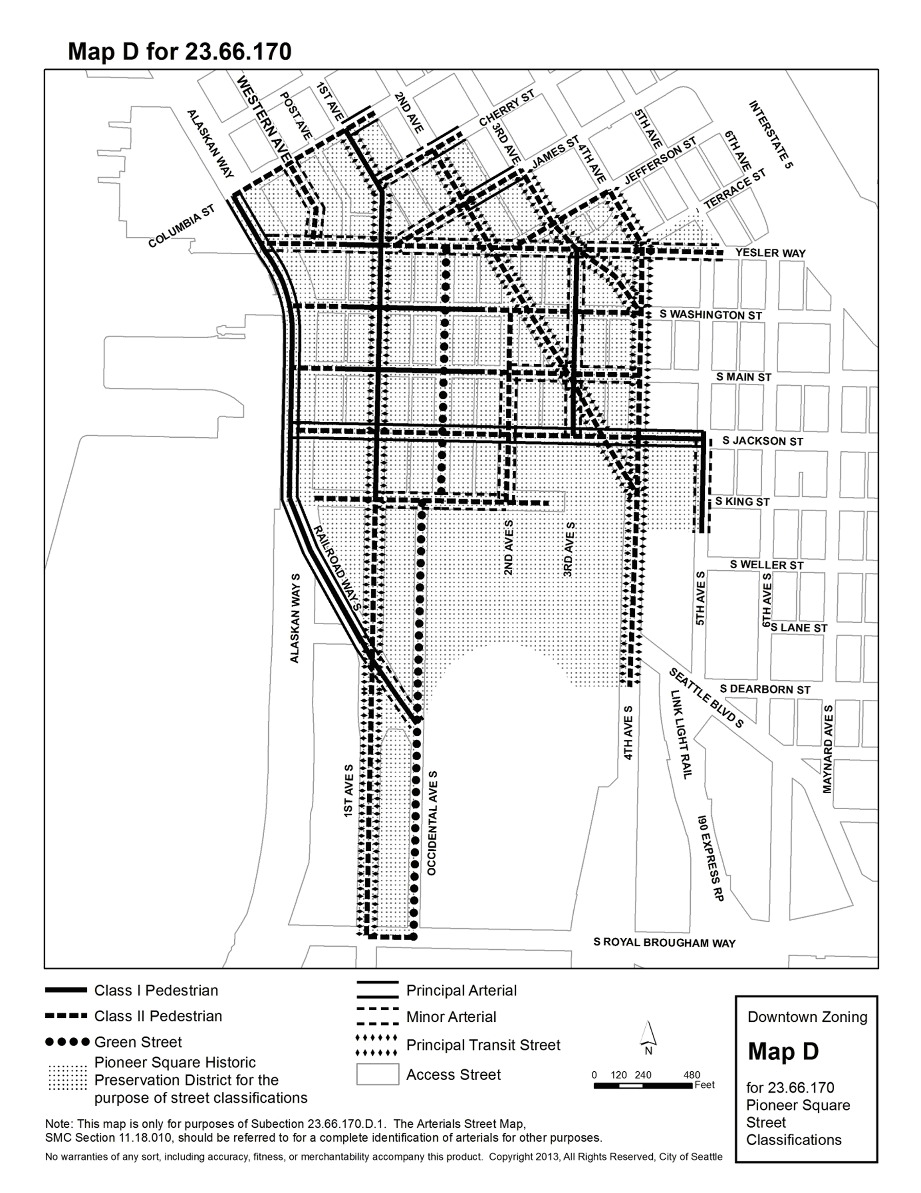
(Ord. 124680, § 13, 2015; Ord. 123034, § 12, 2009; Ord. 122054 § 77, 2006; Ord. 120611, § 17, 2001; Ord. 119484 § 40, 1999; Ord. 118409 § 207, 1996: Ord. 116744 § 42, 1993; Ord. 113279 § 31, 1987; Ord. 112519 § 39, 1985; Ord. 112134 § 1(part), 1985.)
23.66.180 - Exterior building design.
To complement and enhance the historic character of the District and to retain the quality and continuity of existing buildings, the following requirements shall apply to exterior building design:
A.
Materials. Unless an alternative material is approved by the Department of Neighborhoods Director following Board review and recommendation, exterior building facades shall be brick, concrete tinted a subdued or earthen color, sandstone or similar stone facing material commonly used in the District. Aluminum, painted metal, wood and other materials may be used for signs, window and door sashes and trim, and for similar purposes when approved by the Department of Neighborhoods Director as compatible with adjacent or original uses, following Board review and recommendation.
B.
Scale. Exterior building facades shall be of a scale compatible with surrounding structures. Window proportions, floor height, cornice line, street elevations and other elements of the building facades shall relate to the scale of the buildings in the immediate area.
C.
Awnings. Awnings shall be functional, serving as weather protection for pedestrians at street level, and shall overhang the sidewalk a minimum of five feet (5'). Awnings may be permitted on upper floors for the purpose of climate control. All awnings shall be of a design compatible with the architecture of buildings in the area.
(Ord. 116744 § 43, 1993; Ord. 112134 § 1(part), 1985.)
23.66.190 - Streets and sidewalks.
A.
Review by the Preservation Board shall be required before any changes are permitted to sidewalk prism lights, sidewalk widths or street paving and curbs.
B.
New access to underground areaways shall be limited to access from buildings, except that new access through the sidewalks shall be permitted where stair access existed at any time prior to September 17, 1981, or as approved by the Department of Neighborhoods Director after review and recommendation by the Preservation Board.
(Ord. 116744 § 44, 1993; Ord. 112134 § 1(part), 1985.)
23.66.302 - International Special Review District goals and objectives
The International District is the urban focal point for the Asian American community. The International Special Review District is established to promote, preserve and perpetuate the cultural, economic, historical, and otherwise beneficial qualities of the area, particularly the features derived from its Asian heritage, by:
A.
Reestablishing the District as a stable residential neighborhood with a mixture of housing types;
B.
Encouraging the use of street-level spaces for pedestrian-oriented retail specialty shops with colorful and interesting displays;
C.
Protecting the area and its periphery from the proliferation of parking lots and other automobile-oriented uses;
D.
Encouraging the rehabilitation of existing structures;
E.
Improving the visual and urban design relationships between existing and future buildings, parking garages, open spaces and public improvements within the International District;
F.
Exercising a reasonable degree of control over site development and the location of off-street parking and other automobile-oriented uses; and
G.
Discouraging traffic and parking resulting from athletic stadium events and commuters working outside the District.
All property within the International Special Review District, as designated on the Official Land Use Map, shall be subject to the use and development standards of the underlying zoning and the applicable use and development standards of this Chapter 23.66. In the event of irreconcilable differences between the use and development standards of this Chapter 23.66 and the provisions of the underlying zone or other chapters of the Seattle Municipal Code or other City ordinances, this Chapter 23.66 applies, except that nothing in this Chapter 23.66 shall permit any use or development on a lot from which TDR or TDP are transferred that is inconsistent with the restrictions applicable as a result of such transfer pursuant to Chapter 23.49 or Chapter 23.58A. The boundaries of the International Special Review District are shown on the Official Land Use Map, and on Map A for 23.66.302, included at the end of this Chapter 23.66.
(Ord. 123589, § 80, 2011; Ord. 112134 § 1(part), 1985.)
23.66.304 - International District Mixed (IDM) Zone goals and objectives.
The IDM zone designation shall recognize and promote the area's unique social mix and urban design character. This area is the core of the International District which exemplifies Asian culture. A wide range of uses, including street-level retail, housing development above street level, and the rehabilitation of existing buildings, shall be encouraged. New residential uses and the rehabilitation of existing structures shall be encouraged to provide a diversity of residential opportunities. Specific objectives include the following:
A.
To maintain and protect the International District core as an Asian cultural, retail and residential center;
B.
To allow flexibility and discretion in land use controls, regulations and guidelines to address present conditions and those which may develop in the future;
C.
To protect, preserve and promote small retail and commercial businesses;
D.
To encourage development of housing above street level;
E.
To encourage the rehabilitation of existing buildings; and
F.
To assure new development compatible in scale and character with existing buildings.
(Ord. 112519 § 40, 1985: Ord. 112134 § 1(part), 1985.)
23.66.306 - International District Residential (IDR) Zone goals and objectives
The International District residential area shall be predominantly a residential neighborhood with primarily residential uses. Other compatible uses shall be permitted to the extent that they reinforce and do not detract from the primary use of the area. The IDR designation and the regulations of the International Special Review District shall recognize and promote the area's unique social and urban design character. Special objectives include:
A.
The establishment of the International District area north of South Jackson Street as one of downtown's predominant residential neighborhoods;
B.
The development of flexible land use controls, regulations and guidelines to address present conditions and those which may develop in the future;
C.
The design, siting, and construction of structures that minimize view blockage from Kobe Terrace Park and from existing structures that are used primarily for residential purposes;
D.
The design, siting and construction of structures in a manner that allows reasonable solar exposure and air circulation to adjacent properties;
E.
The design, siting and construction of structures that are aesthetically compatible with the area's steep topography and/or nearby public open spaces.
(Ord. 123589, § 81, 2011; Ord. 112519, § 41, 1985; Ord. 112134, § 1(part), 1985.)
23.66.308 - International District preferred uses east of Interstate 5
Preferred uses for that portion of the International District that lies east of Interstate 5 include restaurants, retail shops, residential uses, and other small- and medium-scale commercial uses. Commercial businesses and uses with an Asian product, service or trade emphasis are preferred. Preferred uses should contribute to the International District's business core or to the function and purposes of the International District east of Interstate 5.
(Ord. 123589, § 82, 2011; Ord. 112134, § 1(part), 1985.)
23.66.310 - Union Station Corridor goals and objectives
The Union Station Corridor is that area bounded by Yesler Way, Fifth Avenue South, Airport Way South, and Fourth Avenue South. The City, in cooperation with King County Metro, local property owners and the affected community, formulated a strategy for the redevelopment of the Union Station Corridor in coordination with the Downtown Transit Project. Specific objectives for a Planned Community Development in the Union Station Corridor include the following:
A.
Preservation. The historic Union Station structure should be retained and rehabilitated with consideration given to a mix of private and public uses.
B.
Uses. Development in the Corridor should incorporate a mix of uses, such as office, housing, hotel, and retail uses in conformance with its International District zoning and the regulations of the International Special Review District. Retention of low-income housing should be given a high priority. Consideration should be given to the inclusion of public open space and public uses serving the community.
C.
Planned Community Development. The provisions of Section 23.49.036, Planned Community Developments, apply in the area. This procedure allows projects to modify the provisions of the IDM designation as long as the entire project is in conformance. All planned community developments shall be reviewed by the International Special Review District Board which shall make a recommendation to the Director of Neighborhoods.
D.
Open Space. Public open space has been included in development in the area, and if applicable to future development proposals, consideration should be given to the retention and enhancement of a linear open space along Fifth Avenue south of Jackson Street, as an open space resource and a major focal point at the west end of King Street.
E.
Parking. The number of parking spaces provided in the corridor should be sufficient to meet the requirements for development in the corridor, as well as to contribute to the long-range needs of the International District.
F.
Scale. Building height and bulk should conform to the IDM Zone designation and the regulations of the International Special Review District. Development south of Jackson Street should preserve the Union Station building as the dominant structure.
G.
View Corridors. Views from Jackson and King Streets should be retained.
H.
Pedestrian Environment. To provide a pedestrian link between the International District retail core and Pioneer Square, a pedestrian connection should be retained south of King Street. Consideration should be given to pedestrian improvements along Jackson Street and along Fifth Avenue between Jackson Street and Airport Way South such as streetscaping, widened sidewalks and benches, to "humanize" what are now vehicular-oriented streets.
(Ord. 126855, § 58, 2023; Ord. 123589, § 83, 2011; Ord. 116744, § 45, 1993; Ord. 112519, § 42, 1985; Ord. 112134, § 1(part), 1985.)
23.66.312 - Composition of the Special Review Board.
The International District Special Review Board (hereafter, the "Board") shall consist of seven (7) members, five (5) of whom are elected and two (2) of whom are appointed by the Mayor and confirmed by the City Council. The five (5) elected members of the Board shall consist of two (2) members who own property in the International District, or who own or are employed by businesses located in the International District; two (2) members who are either residents (including tenants), or persons with a recognized and demonstrated interest in the welfare of the International District Community; and one (1) member at large. One (1) member of the Pioneer Square Special Review Board shall serve as a nonvoting member appointed by the Pioneer Square Special Review Board to serve at that Board's pleasure.
(Ord. 112134 § 1(part), 1985.)
23.66.314 - Staff support for the Special Review Board.
The Department of Neighborhoods Director shall provide staff and clerical support for the Board, and shall assign a member of the Department's staff to act as Board Coordinator. The Coordinator shall be the custodian of the Board's records, handle official correspondence, and organize and supervise the clerical and technical work of the Board. The Coordinator shall also recommend such actions, policies, rules and regulations for adoption by the board as may be necessary to accomplish the objectives of this chapter.
(Ord. 116744 § 46, 1993: Ord. 112134 § 1(part), 1985.)
Part 2 Use and Development Standards
23.66.316 - Decision on certificate of approval.
The Board shall review all applications for use or development within the International District which require a certificate of approval. The Board's review shall be conducted according to the procedures and timelines set forth in section 23.66.030 D2 of this Land Use Code. The Board shall make a written recommendation based upon the extent to which the proposal is consistent with the goals and objectives of the International Special Review District and the use and development standards of this chapter. The Department of Neighborhoods Director shall make and issue a decision according to the procedures and timelines set forth in section 23.66.030 D of this Land Use Code.
(Ord. 118012 § 21, 1996: Ord. 116744 § 47, 1993: Ord. 112134 § 1(part), 1985.)
23.66.318 - Demolition approval
A.
To discourage the unnecessary demolition of useful existing structures that contribute to the District's cultural and social character, an assessment of the structure proposed to be demolished shall be prepared and circulated to the Board prior to its consideration of a certificate of approval. Among other factors, the economic, social and physical consequences and benefits of the requested demolition and any alternatives to demolition shall be assessed. Except as provided in subsection 23.66.318.B, a certificate of approval may be granted only if the requested demolition will not adversely affect the District and no reasonable alternatives to demolition exist, and if:
1.
The Director of Neighborhoods, after receiving a recommendation by the Special Review Board, determines that the building or structure has no important architectural or historic significance; and
2.
Use and design of a replacement structure have been approved by the Director of Neighborhoods; and
3.
Proof acceptable to the Director of Neighborhoods of a valid commitment for interim and long-term financing for the replacement structure has been secured. In addition to other proof, the Director of Neighborhoods may accept a bond, letter of credit, or cash deposit as a demonstration that the project has adequate financial backing to ensure completion; and
4.
Satisfactory arrangements have been made for retention of any part of the structure's facade that the Director of Neighborhoods and Special Review Board determine to be significant; and
5.
Satisfactory assurance is provided that new construction will be completed within two years of demolition.
B.
If demolition or removal of a building or other structure in the District is essential to protect the public health, safety and welfare or if the purposes of this Chapter 23.66 will be furthered by the demolition or removal, then the Director of Neighborhoods, following review and recommendation by the Board, may authorize such demolition or removal whether the prerequisites of this Section 23.66.318 are satisfied or not.
C.
Pursuant to RCW 36.70B.140, the Director of Neighborhoods' decision is exempt from the time limits and other requirements of RCW 36.70B.060 through 36.70B.080 and the requirements of RCW 36.70B.110 through 36.70B.130.
D.
There is no administrative appeal of the decision of the Director of Neighborhoods. The Director of Neighborhoods' decision shall be final. Any judicial review must be commenced as provided by state law.
(Ord. 124378, § 66, 2013; Ord. 123589, § 84, 2011; Ord. 120157 § 4, 2000; Ord. 118181 § 3, 1996; Ord. 116744 § 48, 1993: Ord. 112134 § 1(part), 1985.)
23.66.320 - Permitted uses
A.
All uses shall be permitted outright except those specifically prohibited by Section 23.66.322 and those subject to special review under Section 23.66.324.
B.
All uses not specifically prohibited shall be permitted as both principal and accessory uses except:
1.
Gas stations, which are not permitted as principal uses and are permitted as accessory uses only in parking garages;
2.
Surface parking areas, which are not permitted as principal uses but may be permitted as accessory uses pursuant to Section 23.66.342; and
3.
Flexible-use parking garages, which may be permitted only if approved after special review by the Board pursuant to Section 23.66.324. Accessory parking garages shall be permitted outright.
(Ord. 125558, § 52, 2018; Ord. 112134 § 1(part), 1985.)
23.66.322 - Prohibited uses
A.
The following uses are prohibited as both principal and accessory uses in the entire International Special Review District:
1.
Adult motion picture theaters;
2.
Adult panorams;
3.
All general and heavy manufacturing uses;
4.
All high-impact uses;
5.
Solid waste management;
6.
Recycling uses;
7.
Automotive sales and service;
8.
Bowling lanes;
9.
Major communication utilities;
10.
Heavy commercial sales;
11.
Drive-in businesses;
12.
Frozen food lockers;
13.
Heavy commercial services;
14.
Marine sales and services;
15.
Medical testing laboratories;
16.
Mortuary services;
17.
Motels;
18.
Outdoor storage;
19.
Plant nurseries;
20.
Retail ice dispensaries;
21.
Shooting galleries;
22.
Skating rinks;
23.
Mobile home parks;
24.
Transportation facilities except: passenger terminals, rail transit facilities, and parking and moorage uses;
25.
Animal shelters and kennels;
26.
Jails;
27.
Major cannabis activity; and
28.
Work-release centers.
B.
In addition to the prohibited uses listed in subsection 23.66.322.A, light manufacturing uses that occupy more than 10,000 square feet are prohibited in that portion of the International Special Review District west of Interstate 5.
C.
All light manufacturing uses are prohibited in that portion of the District in an IDR zone.
(Ord. 127099, § 52, 2024 [changed "marijuana" to "cannabis"]; Ord. 124969, § 23, 2016; Ord. 123589, § 85, 2011; Ord. 122311, § 80, 2006; Ord. 120928 § 40, 2002; Ord. 114623 § 17, 1989; Ord. 112777 § 34, 1986; Ord. 112519 § 43, 1985; Ord. 112303 § 8, 1985; Ord. 112134 § 1(part), 1985.)
23.66.324 - Uses subject to special review
A.
Uses subject to special review require approval of the Department of Neighborhoods Director after review and recommendation by the Board. Approval may be granted, conditioned, or denied based on consideration of the recommendation and the criteria in this Section 23.66.324 and in Section 23.66.326, if applicable. The following uses are subject to special review by the Board:
1.
Formula fast food restaurants;
2.
Hotels;
3.
Planned community developments;
4.
Flexible-use parking garages;
5.
Street-level uses subject to special review as provided in subsection 23.66.326.C; and
6.
Accessory surface parking areas, if located in a Downtown Mixed Residential zone within the International Special Review District.
B.
Nature of review
1.
The evaluation of applications for uses subject to special review shall be based upon the proposal's impacts on the cultural, economic, social, historical, and related characteristics of the International District, particularly those characteristics derived from its Asian heritage; existing and potential residential uses; the pedestrian environment; traffic and parking in the District; noise and light and glare.
2.
In addition to the criteria in subsection 23.66.324.B.1, in reviewing applications in a Downtown Mixed Residential zone for flexible-use parking garages or accessory surface parking areas, the Board shall also consider the potential of the proposal to serve the particular parking needs of the International District. The Board shall encourage participation in an area-wide merchants' parking association.
(Ord. 125558, § 53, 2018; Ord. 123589, § 86, 2011; Ord. 121145 § 15, 2003; Ord. 112303 § 9, 1985: Ord. 112134 § 1(part), 1985.)
23.66.326 - Street-level uses
A.
To retain and strengthen the King Street business core as a pedestrian-oriented retail shopping district, street-level uses are required on streets within the Retail Core designated on Map B for 23.66.326. Required street-level uses shall satisfy the standards of this Section 23.66.326.
B.
Preference shall be given to pedestrian-oriented retail shopping and service businesses that are highly visible or prominently display merchandise in a manner that contributes color and activity to the streetscape, including but not limited to:
Apparel shops;
Asian arts, crafts, and specialty goods shops;
Bakeries;
Banks;
Barbecue shops;
Bookstores;
Coffee shops;
Floral shops;
Groceries;
Museums;
Personal services such as beauty shops and barbershops;
Restaurants;
Sidewalk cafes;
Tea shops;
Travel agencies;
Variety stores.
C.
The Board may, following a special review of potential impacts, including, but not limited to traffic, parking, noise and the scale and character of the pedestrian environment, recommend to the Director of Neighborhoods that the following uses at street level be approved if the impacts of such uses are not significantly adverse:
Appliance repair shops;
Research and development laboratories;
Radio and television studios;
Residential uses;
Taxidermy shops;
Upholstery establishments;
Vocational or fine arts schools;
Warehouses or wholesale showrooms, especially if they include storage of jewelry, optical or photographic goods, pharmaceuticals, cosmetics, and other similar high-value, low-bulk articles.
The Board may recommend, and the Director may impose, conditions to mitigate the impacts of approved uses.
D.
Standards for Required Street-level Uses.
1.
Street-level uses within the Retail Core designated on Map B for 23.66.326 shall not exceed 50 feet of street frontage per use if located within the interior portion of a block, or 145 feet of street frontage per use if located on a corner.
2.
Street-level uses shall comply with exterior building finish requirements of Section 23.66.336.
E.
Within the Retail Core, nonpedestrian-oriented uses and businesses that are not typically visible from the sidewalk may not exceed 25 feet of street frontage per use if located within the interior portion of a block, or 145 feet of street frontage per use if located on a corner. Nonpedestrian-oriented uses include but are not limited to:
Community clubs or centers;
Family associations;
Human service uses;
Nonprofit community service organizations;
Theaters and spectator sports facilities.
F.
Outside the Retail Core, development on lots abutting S. Jackson Street east of Interstate 5 and/or 12 th Avenue S. as shown on Map B for 23.66.326 shall comply with the street-level use requirements set forth in Section 23.49.009.
G.
To promote street-level activity in commercial structures outside the Retail Core, street level uses identified in subsection 23.66.326.B are required along a minimum of 50 percent of each street frontage of any structure that contains no residential uses and that is in an IDR zone or is in an IDM 75/85-150 zone. This standard may be waived by the Director of Neighborhoods, after consultation with the Board, if it is determined that the proposed uses and design of the structure at street-level are compatible with the character of the surrounding neighborhood and the goals and objectives of the International Special Review District and of the zone in which the structure is located.
(Ord. 123589, § 87, 2011; Ord. 122311, § 81, 2006; Ord. 116744 § 49, 1993; Ord. 112303 § 10, 1985: Ord. 112134 § 1(part), 1985.)
23.66.328 - Uses above street level
A.
To encourage and facilitate the rehabilitation and renovation of existing structures for housing or other uses not preferred at street level, uses above street level on streets within the Retail Core designated on Map B for 23.66.326, shall meet the standards of this Section 23.66.328.
B.
Residential uses and non-vehicular-oriented commercial uses that primarily serve the District and are in operation throughout the day are preferred. Preferred uses above street level include but are not limited to:
Community clubs and centers;
Expansion of existing retail sales and service uses at street level;
Medical services, such as offices for doctors or dentists;
Offices;
Hotels;
Vocational or fine arts schools;
Wholesale showrooms.
(Ord. 123589, § 88, 2011; Ord. 112777 § 35, 1986; Ord. 112134 § 1(part), 1985.)
23.66.332 - Height and rooftop features
A.
Maximum structure height is as designated on the Official Land Use Map, Chapter 23.32, except as provided in this Section 23.66.332.
B.
Rooftop features
1.
The Special Review Board and the Director of Neighborhoods shall review rooftop features to preserve views from Kobe Terrace Park.
2.
Religious symbols for religious institutions, as well as smokestacks and flagpoles, are exempt from height controls, except as regulated in Chapter 23.64, provided they are at least 10 feet from all lot lines.
3.
Open railings, planters, clerestories, skylights, play equipment, parapets and firewalls may extend up to 4 feet above the maximum height limit and may have unlimited rooftop coverage.
4.
Solar collectors excluding greenhouses may extend up to 7 feet above the maximum height limit and may have unlimited rooftop coverage.
5.
The following rooftop features may extend up to 15 feet above the maximum height limit provided that the combined coverage of all features listed below does not exceed 25 percent of the roof area:
a.
Solar collectors, excluding greenhouses;
b.
Mechanical equipment that is set back at least 15 feet from the roof edge, except as may be permitted by subsection 23.66.332.B.6.c;
c.
Minor communication utilities and accessory communication devices, except that height is regulated according to Section 23.57.014.
6.
Stair and elevator penthouses and greenhouses may extend above the applicable height limit up to 15 feet provided that the combined rooftop coverage of these features and all features listed in subsection 23.66.332.B.5 does not exceed 30 percent of the roof area. Greenhouses shall be set back at least 15 feet from a roof edge abutting a street.
a.
Notwithstanding height provisions in Section 23.49.008.D.2.b, when additional height is needed to accommodate elevators for a new structure in IDR or IDR/C zones with height limits of 125 feet or greater, elevator penthouses may extend above the height limit an amount needed to accommodate the elevator and its equipment penthouse if permitted subject to review by the Special Review Board and approval by the Director of Neighborhoods. When additional height is allowed for an elevator, stair penthouses may be granted the same additional height if they are co-located with the elevator penthouse.
b.
Except as may be permitted by other provisions in subsections 23.66.332.B.5 and 23.66.332.B.6 additional combined coverage of the rooftop features listed in subsections 23.66.332.B.5 and 23.66.332.B.6, not to exceed 35 percent of the roof area, may be permitted subject to review by the Special Review Board and approval by the Director of Neighborhoods. If the rooftop coverage includes a greenhouse, additional combined coverage of the rooftop features listed in subsections 23.66.332.B.5 and 23.66.332.B.6, not to exceed 45 percent of the roof area, may be permitted subject to review by the Special Review Board and approval by the Director of Neighborhoods.
c.
For new structures that exceed 125 feet in IDR or IDR/C zones, exceedance of combined coverage limits for the rooftop features listed in subsections 23.66.332.B.5 and 23.66.332.B.6, and reduction in 15-foot setbacks of mechanical equipment from the roof edge, may be permitted subject to review by the Special Review Board and approval by the Director of Neighborhoods.
7.
Structures existing prior to June 1, 1989 may add new or replace existing mechanical equipment up to 15 feet above the existing roof elevation of the structure as long as it is set back at least 15 feet from the roof edge subject to review by the Special Review Board and approval by the Director of Neighborhoods.
8.
Screening of rooftop features. Measures may be taken to screen rooftop features from public view subject to review by the Special Review Board and approval by the Director of Neighborhoods. The amount of roof area enclosed by rooftop screening may exceed the maximum percentage of the combined coverage of rooftop features listed in subsection 23.66.332.B.5. In no circumstances shall the height of rooftop screening exceed 15 feet above the maximum height limit.
9.
For height exceptions for communication utilities and devices, see Section 23.57.014.
(Ord. 126600, § 16, 2022; Ord. 125603, § 64, 2018; Ord. 123589, § 90, 2011; Ord. 120928, § 41, 2002; Ord. 120117, § 49, 2000; Ord. 119370, § 18, 1999; Ord. 112134, § 1, 1985.)
23.66.334 - Streets and sidewalks
Review by the Special Review Board and approval by the Director of Neighborhoods are required before any changes may be made to sidewalk prism lights, sidewalk furniture, sidewalk widths, or street paving and curbs. Review by the Special Review Board and the Director of Neighborhoods, with respect to the International Special Review District goals and objectives in Section 23.66.302 as applicable, are required for any street design concept plan prior to inclusion in the Right-of-Way Improvements Manual.
(Ord. 123589, § 91, 2011; Ord. 116744 § 50, 1993: Ord. 112134 § 1(part), 1985.)
23.66.336 - Exterior building finishes
A.
General Requirements. To retain and enhance the visual order of the District, which is created by existing older buildings that provide unique character and form through their subtle detailing and quarter-block and half-block coverage, new development, including exterior remodeling, should respect the architectural and structural integrity of the building in which the work is undertaken, through sympathetic use of colors, material and style. Exterior building facades shall be of a scale compatible with surrounding structures. Window proportions, floor height, cornice line, street elevations and other elements of the building facades shall relate to the scale of the existing buildings in the immediate area.
B.
Asian Design Character District. The boundaries of the Asian Design Character District of the International District are as shown on Map B for 23.66.326. To strengthen and preserve the existing Asian architectural character of the Asian Design Character District, tiled awnings, recessed balconies, heavy timber construction, and materials and colors as specified below are encouraged.
1.
Materials. Building facades are limited to earthen materials such as brick, concrete, stucco and wood. Other materials may be used if approved by the Director of Neighborhoods. Brick and concrete may not be painted unless approved by the Director of Neighborhoods. Stucco may be used in conjunction with other contrasting materials such as dark stained wood. Decorative ceramic glazed roof tiles are encouraged, as are tiled awnings and marquees if appropriately integrated into the overall design.
2.
Colors. Building facade colors must be reviewed by the Special Review Board and approved by the Director of Neighborhoods. Colors shall be compatible with those of adjacent buildings.
3.
Surfaces. Textured concrete, brick and wood surfaces are preferred over non-textured surfaces. Recesses and voids that break up monotonous surface areas and create visual relief are encouraged. The design and location of mechanical equipment visible from the street must be reviewed by the Board and approved by the Director of Neighborhoods.
4.
Transparency Requirement. Street-level uses shall have highly visible linkages with the street. Transparent surfaces shall be provided for at least 50 percent of the exposed street-facing facade measured between sidewalk level and a height of 10 feet or the height of the second floor level, whichever is less. The average height of window sills shall be no greater than 3 feet above the sidewalk. A decrease in the percentage of required transparency may be permitted by the Board if:
a.
There is a design constraint, such as permanent wainscoting, and removal or alteration would detract from the structural or architectural integrity of the building; or
b.
The existing layout of the building or other physical constraints such as the placement of load bearing walls or columns creates a hardship. If transparency requirements are reduced, wall murals, landscaping, colored awnings, display cases, or other means appropriate to the setting shall be provided to create visual interest.
5.
Awnings. Awnings shall be functional, serving as weather protection for pedestrians at street level. Awnings over sidewalks shall overhang the sidewalk a minimum of five feet. All awnings shall be of a design compatible with the architecture of the area.
C.
Exterior Building Design Outside the Asian Design Character District. Outside the Asian Design Character District, earthen colors and masonry construction with nonmetallic surfaces are preferred. Concrete construction will also be permitted if treated in a manner or incorporated into a design that provides visual interest and avoids large unbroken surface areas.
(Ord. 123589, § 92, 2011; Ord. 116744 § 51, 1993; Ord. 112134 § 1(part), 1985.)
23.66.338 - Signs
A.
The intent of the standards in this Section 23.66.338 is:
1.
To encourage signs that by their design, location, and number are consistent with the goals and objectives of the International Special Review District, and the Union Station Corridor where applicable, and in particular the Asian character of the area;
2.
To promote effective communication of sign messages by avoiding undue proliferation;
3.
To enhance views and sightlines into and down streets; and
4.
To reduce driver distraction and visual blight.
B.
Business establishments may erect signs, including banners and flags that are signs, if the Director of Neighborhoods determines the proposed sign meets the standards in this Section 23.66.338 and issues a certificate of approval, except as provided in subsection 23.66.338.H.
C.
Message.
1.
Except as otherwise provided in this Section 23.66.338, signs are limited to:
a.
Business signs that identify the name of the establishment, its street address, and/or the primary business or service provided or signs with a noncommercial message; and/or
b.
Business signs displaying a product name, if (a) the sign is incidental to other signs on the premises and (b) the establishment or use on the premises is the sole distributor of the product in the District.
2.
Except as provided in subsection 23.66.338.C.1, advertising related to businesses or services not provided on the premises or products not manufactured on the site is prohibited.
D.
Permitted Signs.
1.
The types of signs that may be approved are banners and flags, projecting and non-projecting signs integrated into the building façade, marquee, awning and window signs.
2.
Banners and flags bearing emblems, symbols or messages are permitted and are subject to periodic review to ensure that their appearance is maintained and that they comply with the requirements of this Code.
3.
Signs with messages displaying only time or temperature, or both, are allowed to change display if, in addition to complying with the standards set out in this Section 23.66.338, the message does not flash, display a message for less than ten seconds at a time, or use a video display method.
E.
Prohibited Signs.
1.
The following signs are prohibited throughout the International Special Review District:
Freestanding signs (except signs in parks and those authorized for surface parking lots in subsection 23.66.338.F.1);
roof signs;
portable signs;
off-premises signs;
product advertising signs of a permanent nature except as allowed in subsection 23.66.338.C;
flashing signs;
changing-image signs (including video display methods) except as allowed in subsection 23.66.338.D; and
signs with messages that appear to be in motion or that make a noise.
2.
The Board and the Director of Neighborhoods may delegate to the Director the determination whether a proposed sign is a sign prohibited under subsection 23.66.338.E.1. If the Director determines a proposed sign is a sign prohibited under subsection 23.66.338.E.1, the Director of Neighborhoods shall not send the application to the Board and shall deny the application.
3.
Each owner of an existing off-premises sign that is lawfully authorized in the District shall comply with the requirements in subsection 23.55.014.F to register the sign, pay the registration fee, and display the sign registration number, and is subject to the penalty provisions of that subsection 23.55.014.F.
F.
Surface Parking Lot Signage.
1.
The total signage area permitted for each accessory surface parking lot shall not exceed 1 square foot per parking space up to a maximum of 24 square feet per surface parking lot. The total signage area permitted for each existing principal use surface parking lot shall not exceed ½ square foot per parking space in the lot, up to a maximum of 18 square feet per principal use surface parking lot.
2.
Surface parking lots shall display a sign, counted against the total permitted signage area, with one of the following messages, if applicable:
a.
For accessory surface parking lots, or portions thereof, intended only for customer use: "Customer Parking for (Principal User/s) Only." The sign also may contain the address of the principal user or users and mention validation of parking if applicable. The sign also may contain the information required by state law to lawfully impound unauthorized vehicles.
b.
For accessory or principal use surface parking lots, or portions thereof, intended only for reserved parking: "Reserved Parking". The sign also may contain the name and telephone number of the owner. The sign also may contain the information required by state law to lawfully impound unauthorized vehicles.
3.
Small on-premises directional signs, such as those designating the entrance to or exit from accessory surface parking areas, are permitted if they are 3 or fewer square feet in area and are located at a height 4 or fewer feet above grade at points of egress or ingress. Such signs shall not count against the total permitted sign area.
G.
Illumination.
1.
Neon-lit signs are encouraged to create an exciting and enhanced visual image in the retail core.
2.
Illuminated signs shall be designed and sited in a manner to minimize glare on floors above grade in nearby residences.
H.
Miscellaneous Signs.
1.
Signs that are hand painted, gold leafed or decaled onto the glass area of a building façade and that comply with the standards of this Section 23.66.338 are permitted without the approval of the Director of Neighborhoods or review by the Board if the total area of all such signs does not exceed 4 square feet per business. Signs on glass in excess of 4 square feet per business are subject to review by the Board and approval by the Director of Neighborhoods for visual interest and compatibility with the surrounding area.
2.
Non-illuminated signs consisting of Asian language symbols painted on wood or other non-glass exterior surfaces of structures and that comply with the standards of this Section 23.66.338 are permitted without the approval of the Director of Neighborhoods or review by the Board if the total area of all such signs is 4 square feet or less per business, and are subject to Board review and approval by the Director of Neighborhoods for visual interest and compatibility with the surrounding area if the total area of all such signs is more than 4 square feet per business.
3.
Graphics and paintings are permitted on building walls that do not abut a street lot line only if such graphics and paintings are not used to advertise or identify businesses or products and comply with the building façade provisions of Section 23.66.336. All graphics and paintings on building walls are subject to review by the Board and approval by the Director of Neighborhoods.
4.
Temporary Signs.
a.
The following signs are permitted at all times:
1)
Real estate "for sale," "for rent" and "open house" signs, and signs identifying the architect, engineer or contractor for work currently under construction. The total area for these types of signs in the aggregate shall not exceed 24 square feet per 60 linear feet of street frontage, provided that the design, location, shape, size, color and graphics are approved by the Director of Neighborhoods after review and recommendation by the Board, and provided further that such Director may approve up to 36 square feet if there is more than one user of real estate signs or if the building abuts more than two streets; and
2)
Noncommercial signs. The total area for noncommercial signs in the aggregate shall not exceed 24 square feet per 60 linear feet of street frontage, but where there are multiple users of the building, each business establishment and dwelling unit shall be allowed a minimum of 8 square feet of signage, regardless of the 24 square foot limitation.
b.
The following signs are permitted for 14 consecutive days 4 times a calendar year:
1)
On-premises commercial signs. The total area for on-premises commercial signs in the aggregate shall not exceed 24 square feet per 60 linear feet of street frontage, provided that the design, location, shape, size, color and graphics are approved by the Director of Neighborhoods after review and recommendation by the Board; and
2)
Noncommercial signs. The total area for noncommercial signs in the aggregate shall not exceed 32 square feet per 60 linear feet of street frontage, provided that each dwelling unit shall be allowed 32 square feet of signage.
c.
All temporary signs authorized by this section are subject to the following:
1)
Wind-animated objects other than flags, search lights and devices of a carnival nature are not allowed.
2)
No individual sign shall exceed 12 square feet.
d.
Temporary signs required by law shall be permitted without review or approval.
I.
Criteria for Approval.
1.
When reviewing proposed signs, the Board and the Director of Neighborhoods shall consider the intents set out in subsection 23.66.338.A, the function of the sign, the character, color and scale of buildings in the immediate vicinity, the character, color and scale of the building for which the sign is proposed, the proposed location of the sign on the building's exterior, and the total number and size of signs proposed or existing on the building.
2.
The overall design of a sign including size, shape, texture, method of attachment, graphics, color and lighting, shall be compatible with the use to which the sign refers, with the colors, architectural and design motifs of the building upon which it is to be installed, and with the District.
3.
Signs that incorporate recognizable Asian designs or Asian language symbols in at least 40 percent of their message area, or are multilingual, are preferred.
4.
Signs shall be affixed to structures so that they do not conceal, damage, or disfigure desirable architectural features or details of the structure.
5.
Projecting signs shall be sited in a manner that minimizes view blockage of abutting business signs.
6.
All projecting signs shall be installed or erected so that there are no visible angle iron sign supports above the roof, building face or wall.
J.
Measurement of Sign Area. Sign area is calculated according to subsection 23.86.004.A.
(Ord. 125272, § 55, 2017; Ord. 123589, § 93, 2011; Ord. 120466, § 8, 2001; Ord. 117555 § 5, 1995; Ord. 116744 § 52, 1993; Ord. 112519 § 44, 1985; Ord. 112134 § 1(part), 1985.)
23.66.340 - Minimum maintenance.
All buildings in the District shall be maintained and preserved against decay and deterioration caused by neglect or defective or inadequate weather protection.
(Ord. 112134 § 1(part), 1985.)
23.66.342 - Parking and access
A.
Flexible-use parking garages. Flexible-use parking garages are subject to special review by the Board pursuant to Section 23.66.324. Parking garages shall be designed so that the street-level portion of the garage is committed to pedestrian-oriented uses permitted in the District. When abutting street slopes exceed eight percent this requirement may be waived by the Director of the Department of Neighborhoods, following review and recommendation by the Board. View-obscuring screening may be required by the Director of the Department of Neighborhoods as needed to reduce adverse visual impacts on the area.
B.
Accessory parking and loading
1.
Parking quantity. The number of parking spaces required for any use shall be the number required by the underlying zoning, except that restaurants shall be required to provide one space per 500 square feet for all gross floor area in excess of 2,500 square feet; motion picture theaters shall be required to provide one space per 15 seats for all seats in excess of 150; and other entertainment uses shall be required to provide one space per 400 square feet for all gross floor area in excess of 2,500 square feet.
2.
Exceptions to parking quantity. To mitigate the potential impacts of required accessory parking and loading on the District, the Director of the Department of Neighborhoods, after review and recommendation by the Special Review Board, and after consultation with the Director of Transportation, may waive or reduce required parking, loading, and bicycle parking, under the following conditions:
a.
After incorporating high-occupancy-vehicle alternatives such as carpools and vanpools, required parking spaces exceed the net usable space in all below-grade floors; or
b.
Strict application of the parking, loading, or bicycle parking standards would adversely affect desirable characteristics of the District; or
c.
An acceptable parking and loading plan is submitted to meet parking demands generated by the use. Acceptable elements of the parking and loading plan may include but shall not be limited to the following:
1)
Valet parking service;
2)
Validation system;
3)
Lease of parking from parking management company;
4)
Provision of employee parking; and
5)
Accommodations for commercial deliveries and passenger drop off and pick up.
C.
When parking is provided it shall be subject to the requirements of Section 23.54.030.
D.
Access to Parking.
1.
Access to parking shall be reviewed by the Board on a case-by-case basis, according to the following criteria:
a.
Alley access is preferred.
b.
Conflicts with pedestrian traffic, with efforts to provide continuous street facades, and with transit access shall be minimized.
2.
The number and width of curbcuts shall be as required in Section 23.54.030.
3.
Outside the International District Retail Core, if a lot does not abut an alley and abuts more than one right-of-way, the location of access to parking shall be determined according to subsection 23.49.019.H.1.
4.
The Board may recommend, and the Department of Neighborhoods Director may require, changes to proposed access to parking in order to meet the criteria of this Section 23.66.342.
E.
Special Parking Restrictions.
1.
All new surface parking areas shall be accessory and may be permitted in connection with customer parking which is determined by the Board to be consistent with District goals and policies or area-wide parking plans.
2.
A sign complying with Section 23.66.338 of this Land Use Code shall be required at each parking entrance.
3.
Adequate screening shall be required along the perimeter of each new surface parking area.
(Ord. 126157, § 48, 2020; Ord. 125558, § 54, 2018; Ord. 123589, § 95, 2011; Ord. 122311, § 82, 2006; Ord. 116744, § 53, 1993; Ord. 113279, § 32, 1987; Ord. 112519, § 45, 1985; Ord. 112134, § 1, 1985.)
Map A for 23.66.100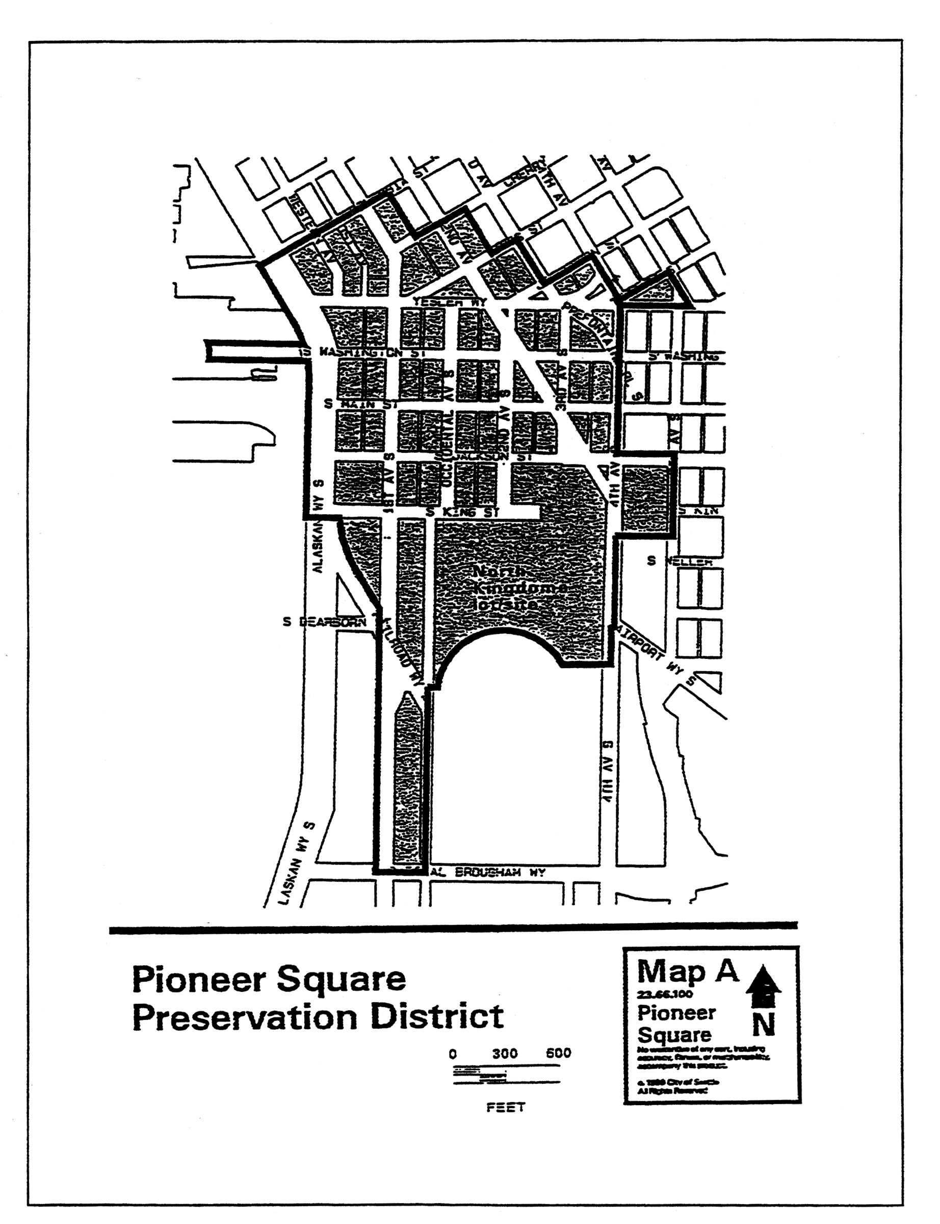
(Ord. 123589, § 94, 2011.)
Map B for 23.66.130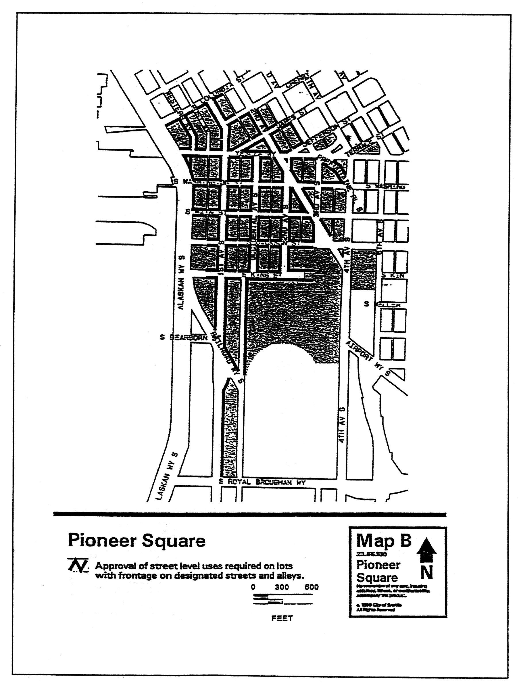
(Ord. 123589, § 94, 2011.)
Map C for 23.66.122 and 23.66.150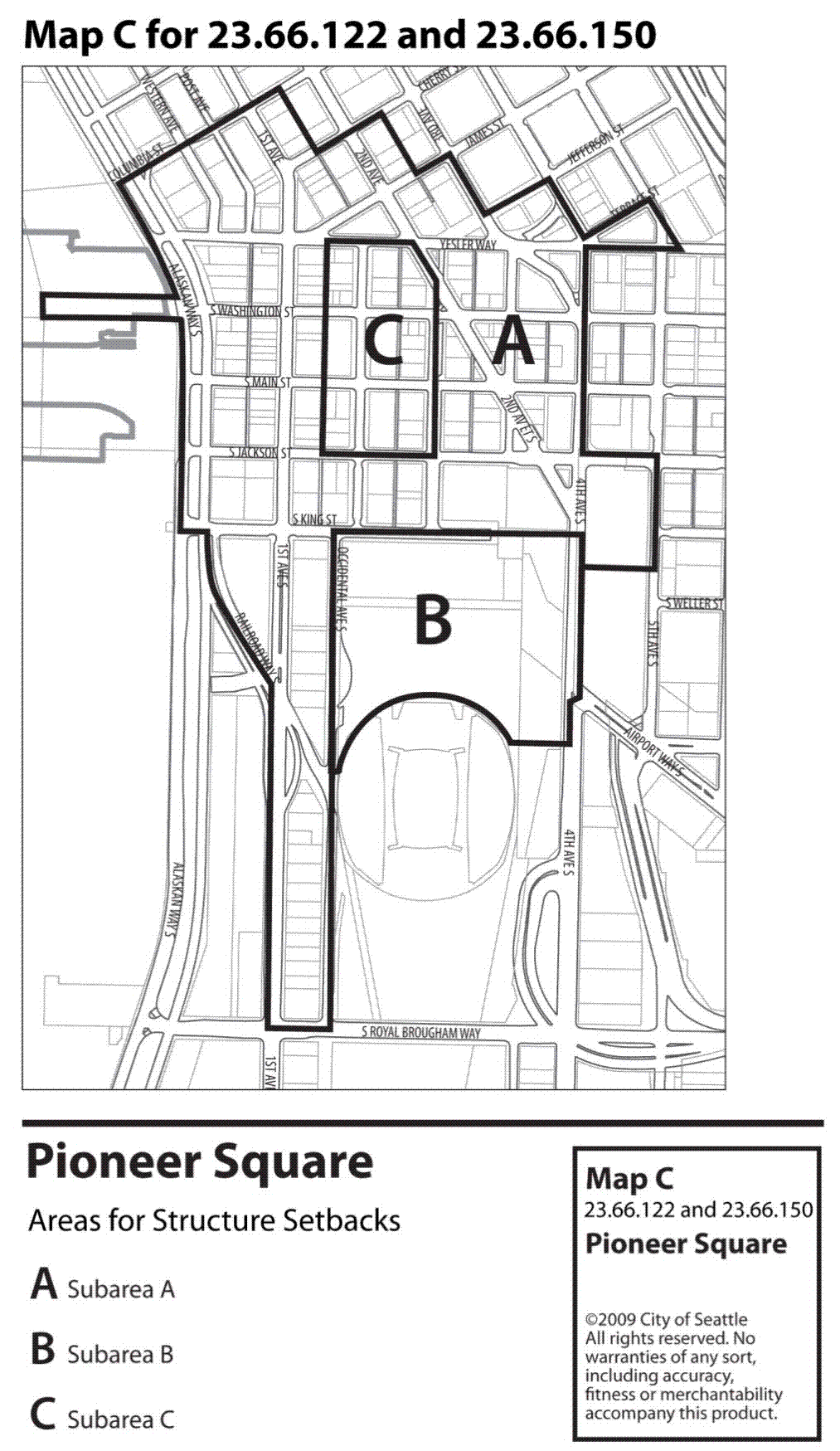
(Ord. 123589, § 94, 2011.)
Map A for 23.66.302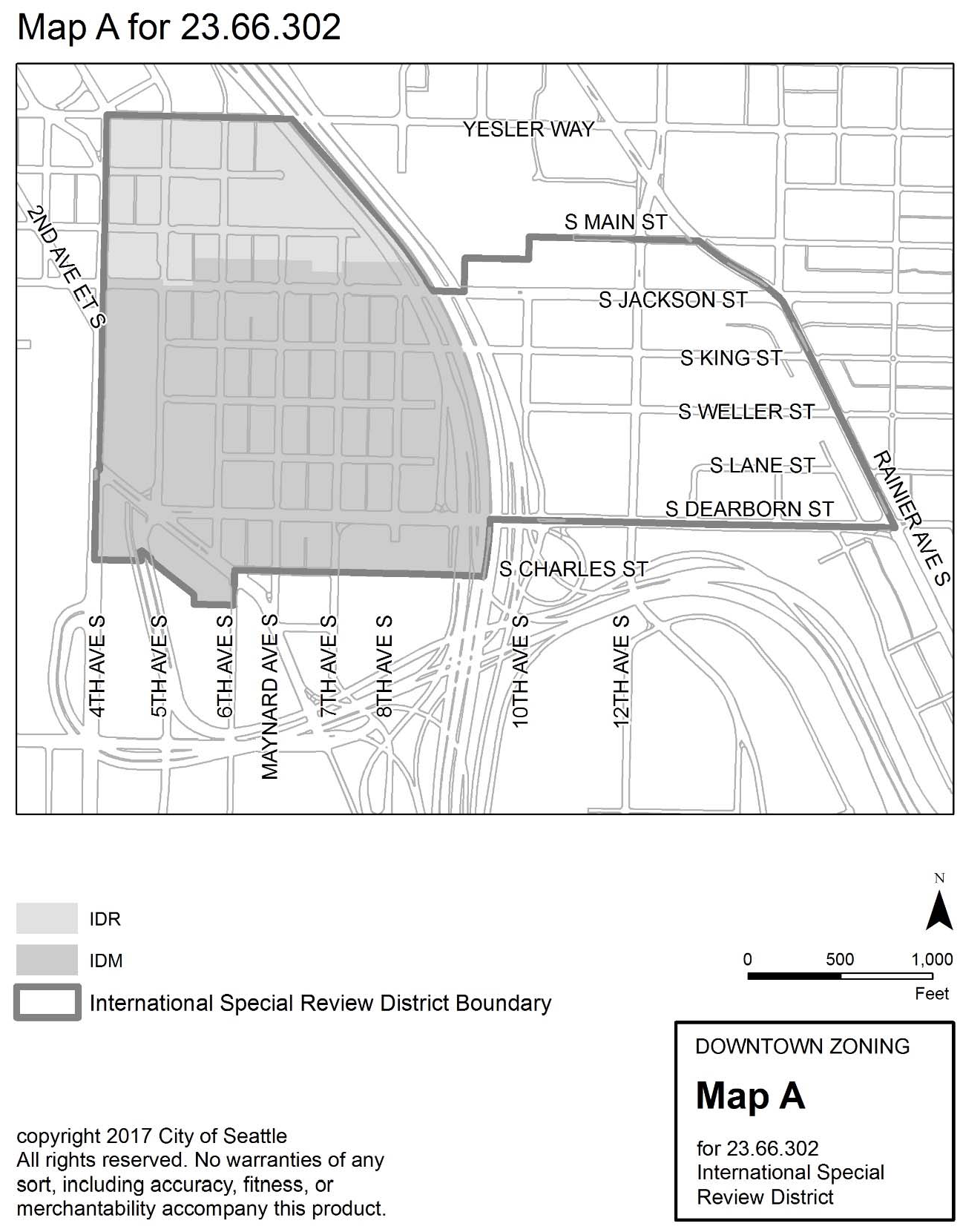
(Ord. 125371, § 23, 2017; Ord. 123589, § 94, 2011.)
Map B for 23.66.326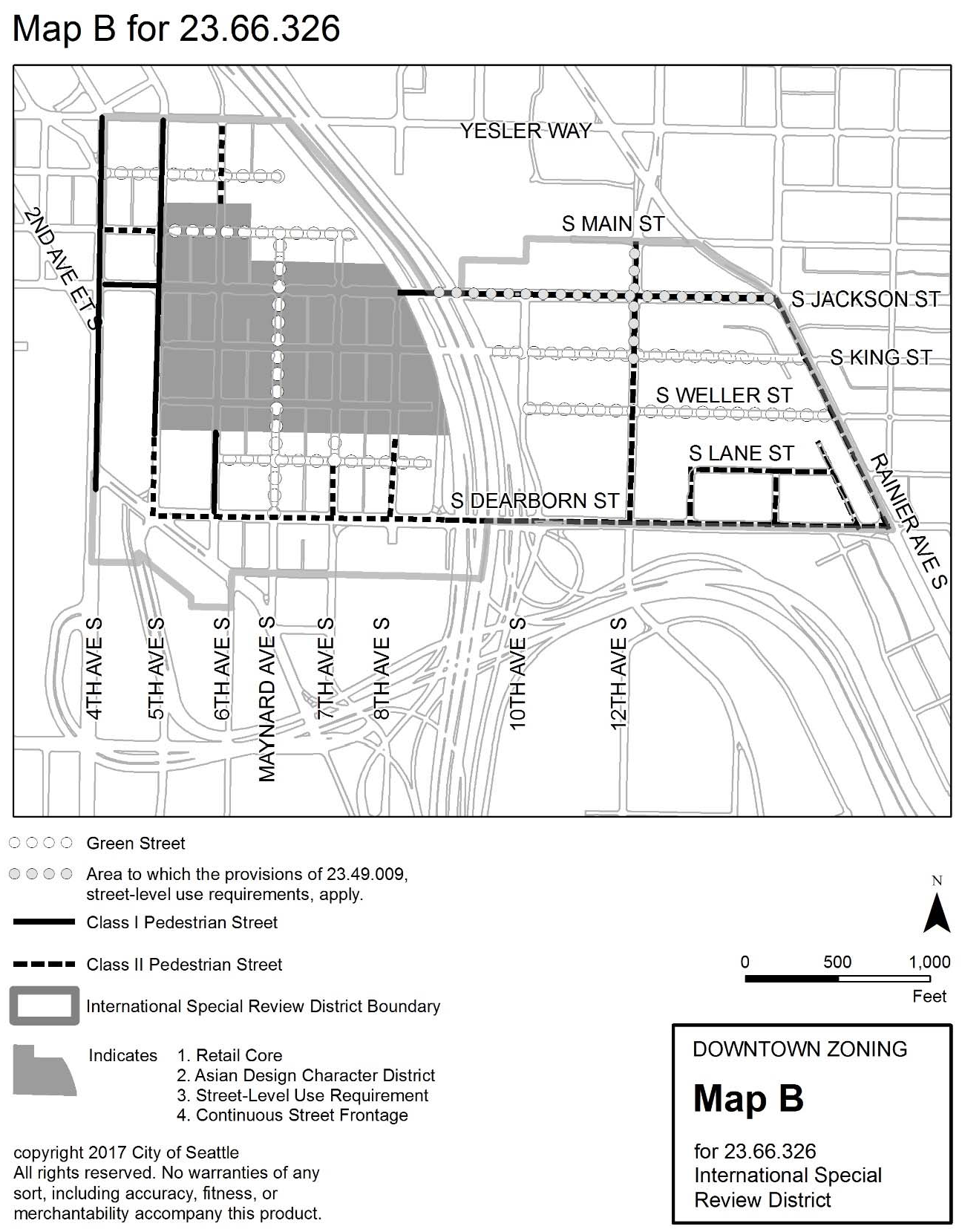
(Ord. 125371, § 24, 2017; Ord. 123589, § 94, 2011.)