
Seattle City Zoning Code
CHAPTER 23
34 - AMENDMENTS TO OFFICIAL LAND USE MAP REZONES
23.34.002 - Standard rezone procedures.
Procedures for amending the Official Land Use Map, including overlay districts and shoreline environment classifications, shall be as provided in Chapter 23.76, Procedures for Master Use Permits and Council Land Use Decisions.
(Ord. 112522 § 6(part), 1985.)
23.34.004 - Contract rezones
A.
Property Use and Development Agreement. The Council may approve a map amendment subject to the execution, delivery, and recording of a property use and development agreement (PUDA) executed by the legal or beneficial owner of the property to be rezoned containing self-imposed restrictions upon the use and development of the property in order to ameliorate adverse impacts that could occur from unrestricted use and development permitted by development regulations otherwise applicable after the rezone. All restrictions imposed by the PUDA shall be directly related to the impacts that may be expected to result from the rezone.
B.
Notwithstanding any contrary provision of subsection 23.34.004.A, the Council may approve a map amendment subject to execution, delivery, and recording of a property use and development agreement (PUDA) executed by the legal or beneficial owner of the property to be rezoned containing self-imposed restrictions applying the provisions of Chapter 23.58B or Chapter 23.58C to the property. The Director shall by rule establish payment and performance amounts for purposes of subsections 23.58C.040.A and 23.58C.050.A that shall apply to a contract rezone until Chapter 23.58C is amended to provide such payment and performance amounts for the zone designation resulting from a contract rezone.
C.
A contract rezone shall be conditioned on performance or compliance with the terms and conditions of the PUDA. Council may revoke a contract rezone or take other appropriate action allowed by law for failure to comply with a PUDA. The PUDA shall be approved as to form by the City Attorney, and shall not be construed as a relinquishment by the City of its discretionary powers.
D.
Waiver of Certain Requirements. The ordinance accepting the PUDA may waive specific bulk or off-street parking and loading requirements if the Council determines that the waivers are necessary under the agreement to achieve a better development than would otherwise result from the application of regulations of the zone. No waiver of requirements shall be granted that would be materially detrimental to the public welfare or injurious to property in the zone or vicinity in which the property is located.
(Ord. 125108, § 3, 2016; Ord. 123913, § 2, 2012; Ord. 122497, § 2, 2007; Ord. 112522, § 6(part), 1985; Ord. 110381, § 1(part), 1982.)
23.34.006 - Application of MHA suffixes in Type IV rezones
A.
When the Council approves a Type IV amendment to the Official Land Use Map that increases development capacity in an area to which Chapters 23.58B and 23.58C have not previously been applied, the following provisions govern application of Chapters 23.58B and 23.58C to the rezoned area through use of a mandatory housing affordability suffix:
1.
If the rezone is to another zone in the same MHA zone category according to Table A for 23.34.006, the new zone should have a (M) suffix.
2.
If the rezone is to another zone that is one category higher than the existing zone according to Table A for 23.34.006, the new zone should have a (M1) suffix.
3.
If the rezone is to another zone that is two or more categories higher than the existing zone according to Table A for 23.34.006, the new zone should have a (M2) suffix.
B.
When the Council approves a Type IV amendment to the Official Land Use Map in an area to which Chapters 23.58B and 23.58C have previously been applied through the use of a mandatory housing affordability suffix, the suffix for the new zone shall be determined as follows:
1.
If the rezone would not increase development capacity or is to another zone in the same MHA zone category according to Table A for 23.34.006, the MHA suffix should not change.
2.
If the rezone is to another zone that is one category higher than the existing zone according to Table A for 23.34.006, the new zone should:
a.
Have a (M1) suffix if it currently has an (M) suffix; or
b.
Have a (M2) suffix if it currently has an (M1) or (M2) suffix.
3.
If the rezone is to another zone that is two or more categories higher than the existing zone according to Table A for 23.34.006, the new zone should have a (M2) suffix.
(Ord. 126509, § 15, 2022 [zone name change]; Ord. 125791, § 3, 2019.)
23.34.007 - Rezone evaluation
A.
The provisions of this chapter apply to all rezones except correction of mapping errors. In evaluating proposed rezones, the provisions of this chapter shall be weighed and balanced together to determine which zone or height designation best meets those provisions. In addition, the zone function statements, which describe the intended function of each zone designation, shall be used to assess the likelihood that the area proposed to be rezoned would function as intended.
B.
No single criterion or group of criteria shall be applied as an absolute requirement or test of the appropriateness of a zone designation, nor is there a hierarchy or priority of rezone considerations, unless a provision indicates the intent to constitute a requirement or sole criterion.
C.
Compliance with the provisions of this Chapter 23.34 shall constitute consistency with the Comprehensive Plan for the purpose of reviewing proposed rezones, except that Comprehensive Plan Shoreline Environment Policies shall be used in shoreline environment redesignations as provided in subsection 23.60A.042.C.
D.
The procedures and criteria for shoreline environment redesignations are located in Sections 23.60A.042, 23.60A.060, and 23.60A.220.
E.
Mapping errors due to cartographic or clerical mistakes may be corrected through process required for Type V Council land use decisions in Chapter 23.76 and do not require the evaluation contemplated by the provisions of this Chapter 23.34.
F.
Mapping errors due to cartographic or clerical mistakes may be corrected through process required for Type V Council land use decisions in SMC Chapter 23.76 and do not require the evaluation contemplated by the provisions of this chapter.
(Ord. 127375, § 6, 2025; Ord. 124105, § 10, 2013; Ord. 122311, § 6, 2006; Ord. 120609, § 2, 2001; Ord. 118408 § 2, 1996; Ord. 117430, § 5, 1994.)
23.34.008 - General rezone criteria
A.
To be approved, a rezone in a regional center shall not reduce the zoned capacity for the center taken as a whole to less than 125 percent of the growth estimates adopted in the Seattle Comprehensive Plan for that center.
B.
Match Between Zone Criteria and Area Characteristics. The most appropriate zone designation shall be that for which the provisions for designation of the zone type and the locational criteria for the specific zone match the characteristics of the area to be rezoned better than any other zone designation.
C.
Zoning History and Precedential Effect. Previous and potential zoning changes both in and around the area proposed for rezone shall be examined.
D.
Regional center plans. Regional center subarea plans adopted by the Council within ten years of the rezone application shall be taken into account.
E.
Zoning principles. The following zoning principles shall be considered:
1.
The impact of more intensive zones on less intensive zones, or industrial and commercial zones on other zones, shall be minimized by the use of transitions or buffers, if possible. A gradual transition between zoning categories, including height limits, is preferred.
2.
Physical buffers may provide an effective separation between different uses and intensities of development. The following elements may be considered as buffers:
a.
Natural features such as topographic breaks, lakes, rivers, streams, ravines, and shorelines;
b.
Freeways, expressways, other major traffic arterials, and railroad tracks;
c.
Distinct change in street layout and block orientation;
d.
Open space and greenspaces.
3.
Zone boundaries
a.
In establishing boundaries, the following elements shall be considered:
1)
Physical buffers as described in subsection 23.34.008.E.2; and
2)
Platted lot lines.
b.
Boundaries between commercial and residential areas shall generally be established so that commercial uses face each other across the street on which they are located, and face away from adjacent residential areas. An exception may be made when physical buffers can provide a more effective separation between uses.
4.
In general, height limits greater than 55 feet should be limited to regional centers, urban centers, neighborhood centers, sites within 125 feet of a street with a frequent transit route, or sites greater than 20,000 square feet. Height limits greater than 55 feet may be considered outside of these areas where higher height limits would be consistent with a Major Institution's adopted master plan or where the designation would be consistent with the existing built character of the area.
F.
Impact evaluation. The evaluation of a proposed rezone shall consider the possible negative and positive impacts on the area proposed for rezone and its surroundings.
1.
Factors to be examined include, but are not limited to, the following:
a.
Housing, particularly low-income housing;
b.
Public services;
c.
Environmental factors, such as noise, air and water quality, terrestrial and aquatic flora and fauna, glare, odor, shadows, and energy conservation;
d.
Pedestrian safety;
e.
Manufacturing activity;
f.
Employment activity;
g.
Character of areas recognized for architectural or historic value;
h.
Shoreline view, public access, and recreation.
2.
Service capacities. Development which can reasonably be anticipated based on the proposed development potential shall not exceed the service capacities which can reasonably be anticipated in the area, including:
a.
Street access to the area;
b.
Street capacity in the area;
c.
Transit service;
d.
Parking capacity;
e.
Utility and sewer capacity;
f.
Shoreline navigation.
G.
Changed circumstances. Evidence of changed circumstances shall be taken into consideration in reviewing proposed rezones, but is not required to demonstrate the appropriateness of a proposed rezone. Consideration of changed circumstances shall be limited to elements or conditions included in the criteria for the relevant zone and/or overlay designations in this Chapter 23.34.
H.
Overlay districts. If the area is located in an overlay district, the purpose and boundaries of the overlay district shall be considered.
I.
Critical areas. If the area is located in or adjacent to a critical area (Chapter 25.09), the effect of the rezone on the critical area shall be considered.
(Ord. 127375, § 7, 2025; Ord. 125791, § 4, 2019; Ord. 125173, § 2, 2016; Ord. 123770, § 1, 2011; Ord. 121700, § 3, 2004; Ord. 120691, §§ 3, 5, 2001; Ord. 120609, § 3, 2001; Ord. 118408, § 3, 1996; Ord. 117929, § 6, 1995; Ord. 117430, § 6, 1994; Ord. 114725, § 1, 1989; Ord. 113079, § 2(part), 1986; Ord. 112522, § 6(part), 1985; Ord. 110381, § 1(part), 1982.)
23.34.009 - Height limits of the proposed rezone
If a decision to designate height limits in residential, commercial, or industrial zones is independent of the designation of a specific zone, in addition to the general rezone criteria of Section 23.34.008, the following shall apply:
A.
Function of the zone. Height limits shall be consistent with the type and scale of development intended for each zone classification. The demand for permitted goods and services and the potential for displacement of preferred uses shall be considered.
B.
Topography of the area and its surroundings. Height limits shall reinforce the natural topography of the area and its surroundings, and the likelihood of view blockage shall be considered.
C.
Height and scale of the area
1.
The height limits established by current zoning in the area shall be given consideration.
2.
In general, permitted height limits shall be compatible with the predominant height and scale of existing development, particularly where existing development is a good measure of the area's overall development potential.
D.
Compatibility with surrounding area
1.
Height limits for an area shall be compatible with actual and zoned heights in surrounding areas excluding buildings developed under Major Institution height limits; height limits permitted by the underlying zone, rather than heights permitted by the Major Institution designation, shall be used for the rezone analysis.
2.
A gradual transition in height and scale and level of activity between zones shall be provided unless major physical buffers, as described in subsection 23.34.008.E.2, are present.
(Ord. 127375, § 8, 2025; Ord. 127099, § 5, 2024; Ord. 124883, § 5, 2015; Ord. 124843, § 6, 2015; Ord. 121476 § 3, 2004; Ord. 117430, § 7, 1994.)
A.
Function. An area that provides for the development of detached, attached, and stacked dwelling units within a predominately three-story height limit.
B.
Locational criteria. An NR zone designation is most appropriate in areas that are generally characterized by the following conditions:
1.
The area is located outside of a regional center, an urban center, or Station Area Overlay District;
2.
The area is characterized by residential structures of generally three stories or less; and
3.
One or more of the following conditions are present:
a.
The area is not located near a major transit stop or on streets abutting frequent transit routes where higher density development might be more appropriate;
b.
A significant portion of the area contains environmentally critical areas; or
c.
The area is characterized by limited local access and circulation that make the area less suitable for higher density development.
(Ord. 127376, § 16, 2025; Ord. 127375, § 10, 2025; Ord. 127219, § 9, 2025; Ord. 126509, § 17, 2022 [zone name change]; Ord. 125791, § 6, 2019; Ord. 122190, § 3, 2006; Ord. 117430, § 9, 1994; Ord. 112522, § 6, 1985; Ord. 110381, § 1, 1982.)
23.34.014 - Lowrise 1 (LR1) zone, function and locational criteria
A.
Function. The function of the LR1 zone is to provide opportunities for the development of detached, attached, and stacked dwelling units within a predominately three-story height limit at a higher intensity than Neighborhood Residential zones.
B.
Locational criteria. The LR1 zone is most appropriate in areas generally characterized by the following conditions:
1.
The area is:
a.
Located outside of an urban center, urban village, or Station Area Overlay District;
b.
A limited area within an urban center, urban village, or Station Area Overlay District that would provide opportunities for a diversity of housing types within these denser environments; or
c.
Located on a collector or minor arterial;
2.
The area is characterized by residential structures of generally three stories or less;
3.
The area is characterized by local access and circulation that can accommodate low density development and the street, and/or by narrow roadways, lack of alleys, and/or irregular street patterns that make local access and circulation less suitable for higher density development;
4.
The area is supported by existing or projected facilities and services used by residents, including retail sales and services, parks, and community centers.
(Ord. 127376, § 19, 2025; Ord. 127375, § 12, 2025; Ord. 126509, § 20, 2022 [zone name change]; Ord. 123495, § 7, 2011; Ord. 117430, § 11, 1994; Ord. 116795, § 3, 1993; Ord. 114886, § 2, 1989.)
23.34.018 - Lowrise 2 (LR2) zone, function, and locational criteria
A.
Functions. The dual functions of the LR2 zone are to:
1.
Provide opportunities for a variety of multifamily housing types in existing multifamily neighborhoods and along arterials that have a mix of small scale residential structures; and
2.
Accommodate redevelopment in areas within regional centers, urban centers, neighborhood centers, and Station Area Overlay Districts in order to establish multifamily neighborhoods of low scale and density.
B.
Locational criteria. The LR2 zone is most appropriate in areas generally characterized by the following conditions:
1.
The area is either:
a.
Located in a regional center, an urban center, a neighborhood center, or a Station Area Overlay District where new development could help establish a multifamily neighborhood of small scale and density; or
b.
Located in or near a regional center, an urban center, a neighborhood center, or a Station Area Overlay District, or on an arterial street, and is characterized by one or more of the following conditions:
1)
Small-scale structures generally no more than 40 feet in height that are compatible in scale with NR and LR1 zones;
2)
The area would provide a gradual transition between NR or LR1 zones and more intensive multifamily or neighborhood commercial zones; and
2.
The area is characterized by local access and circulation conditions that accommodate low-density multifamily development;
3.
The area has direct access to arterial streets that can accommodate anticipated vehicular circulation, so that traffic is not required to use streets that pass through lower density residential zones; and
4.
The area is well supported by existing or projected facilities and services used by residents, including retail sales and services, parks, and community centers, and has good pedestrian access to these facilities.
(Ord. 127375, § 13, 2025; Ord. 126509, § 21, 2022 [zone name change]; Ord. 123495, § 9, 2011; Ord. 123046, § 4, 2009; Ord. 118794, § 9, 1997; Ord. 771430 § 11, 1994; Ord. 116795, § 3, 1993; Ord. 114886, § 2, 1989.)
23.34.020 - Lowrise 3 (LR3) zone, function, and locational criteria
A.
Functions. The dual functions of the LR3 zone are to:
1.
Provide opportunities for a variety of multifamily housing types in existing multifamily neighborhoods, and along arterials that have a mix of small to moderate scale residential structures; and
2.
Accommodate redevelopment in areas within regional centers, urban centers, neighborhood centers, and Station Area Overlay Districts in order to establish multifamily neighborhoods of moderate scale and density.
B.
Locational criteria. The LR3 zone is most appropriate in areas generally characterized by the following conditions:
1.
The area is either:
a.
Located in a regional center, an urban center, a neighborhood center, or a Station Area Overlay District where new development could help establish a multifamily neighborhood of moderate scale and density;
b.
Located in an existing multifamily neighborhood in or near a regional center, an urban center, a neighborhood center, or a Station Area Overlay District, or on an arterial street, and characterized by a mix of structures of low and moderate scale;
c.
On lots within 125 feet of a street with a frequent transit route; or
d.
On a lot greater than 20,000 square feet that does not abut lots zoned Neighborhood Residential over a substantial area;
2.
The area is near neighborhood commercial zones with comparable height and scale;
3.
The area would provide a transition in scale between LR1 and/or LR2 zones and more intensive multifamily and/or commercial zones;
4.
The area has street widths that are sufficient for two-way traffic and parking along at least one curb;
5.
The area is well served by public transit;
6.
The area is located near arterial streets that can accommodate anticipated vehicular circulation;
7.
The area is well supported by existing or projected facilities and services used by residents, including retail sales and services, parks, and community centers, and has good pedestrian access to these facilities.
C.
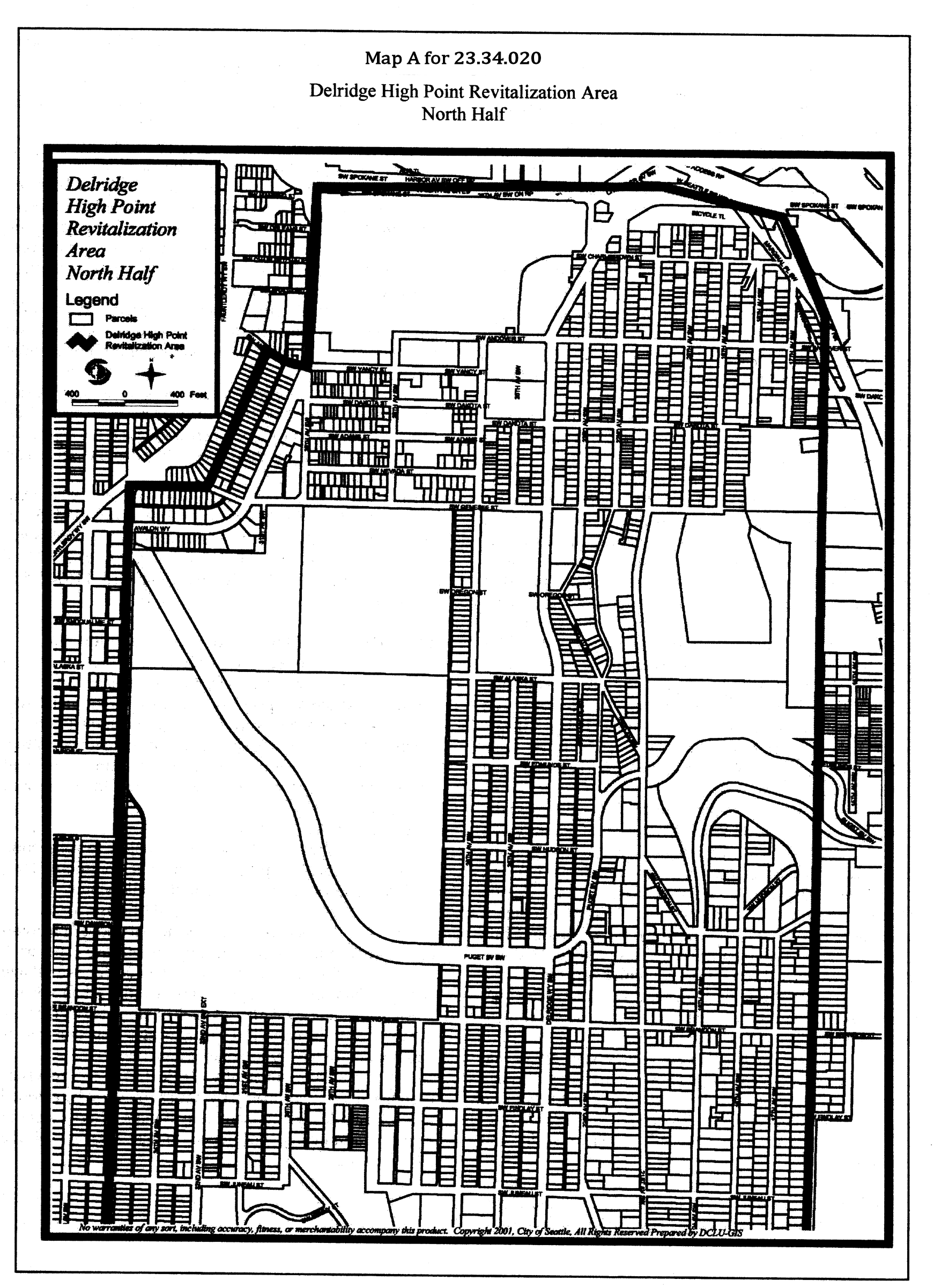
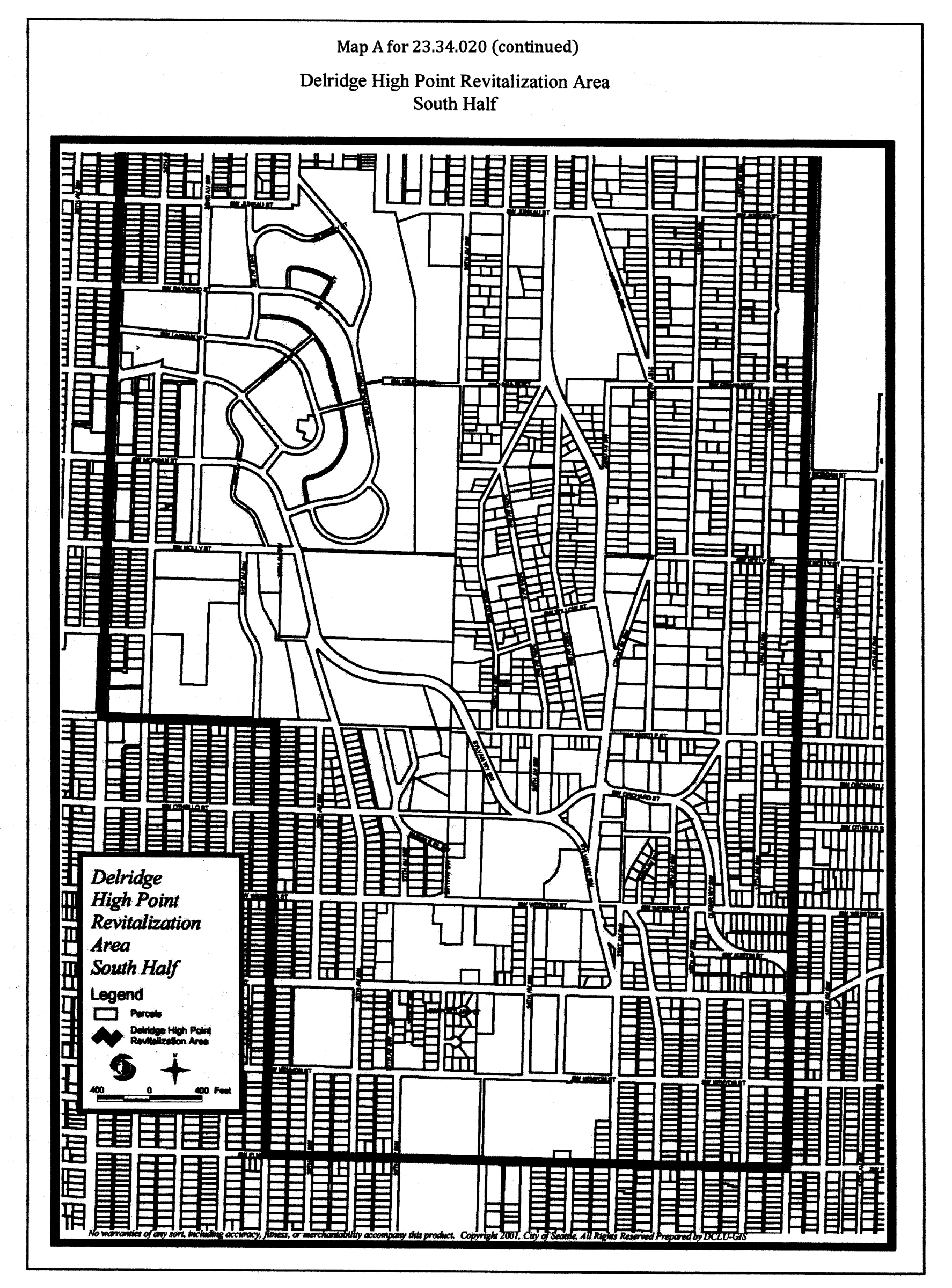
The LR3 zone is also appropriate in the Delridge High Point Neighborhood Revitalization Area, as shown in Map A for 23.34.020, provided that the LR3 zone designation would facilitate a mixed-income housing development initiated by the Seattle Housing Authority or other public agency, a property use and development agreement is executed subject to the provisions of Chapter 23.76 as a condition to any rezone, and the development would serve a broad public purpose.
Map A for 23.34.020: Delridge High Point Revitalization Area—North and South Halves
D.
Except as provided in this subsection 23.34.020.D, properties designated as environmentally critical may not be rezoned to an LR3 designation, and may remain LR3 only in areas predominantly developed to the intensity of the LR3 zone. The preceding sentence does not apply if the environmentally critical area either:
1.
was created by human activity, or
2.
is a designated peat settlement, liquefaction, seismic or volcanic hazard area, or flood prone area, or abandoned landfill.
(Ord. 127375, § 14, 2025; Ord. 126855, § 3, 2023; Ord. 123495, § 10, 2011; Ord. 121700 § 5, 2004; Ord. 120694, § 1, 2001; Ord. 119714 § 4, 1999; Ord. 119691 § 1, 1999; Ord. 119637 § 1, 1999; Ord. 119635 § 1, 1999; Ord. 119521 § 1, 1999; Ord. 119403 § 5, 1999; Ord. 119322 § 5, 1998; Ord. 119217 § 6, 1998; Ord. 118794 § 10, 1997; Ord. 117430, § 11, 1994; Ord. 116795, § 3, 1993: Ord. 114886 § 2, 1989.)
23.34.024 - Midrise (MR) zone, function, and locational criteria
A.
Function. An area that provides concentrations of housing in desirable, pedestrian-oriented urban neighborhoods having convenient access to regional transit stations, where the mix of activity provides convenient access to a full range of residential services and amenities, and opportunities for people to live within walking distance of employment.
B.
Locational criteria
1.
Threshold conditions. Subject to subsection 23.34.024.B.2, properties that may be considered for a Midrise designation are limited to the following:
a.
Properties already zoned Midrise;
b.
Properties in areas already developed predominantly to the intensity permitted by the Midrise zone; or
c.
Properties within a regional center, an urban center, or a neighborhood center.
2.
Environmentally critical areas. Except as stated in this subsection 23.34.024.B.2, properties designated as environmentally critical may not be rezoned to a Midrise designation, and may remain Midrise only in areas predominantly developed to the intensity of the Midrise zone. The preceding sentence does not apply if the environmentally critical area either:
a.
Was created by human activity, or
b.
Is a designated peat settlement; liquefaction, seismic, or volcanic hazard; flood-prone area; or abandoned landfill.
3.
Other criteria. The Midrise zone designation is most appropriate in areas generally characterized by the following:
a.
Properties that are adjacent to business and commercial areas with comparable height and bulk;
b.
Properties in areas that are served by major arterials and where frequent transit service and street capacity could absorb the traffic generated by midrise development;
c.
Properties in areas that are in close proximity to major employment centers;
d.
Properties in areas that are in close proximity to open space and recreational facilities;
e.
Properties in areas along arterials where topographic changes either provide an edge or permit a transition in scale with surroundings;
f.
Properties in flat areas where the prevailing structure height is greater than 37 feet or where due to a mix of heights, there is no established height pattern;
g.
Properties in areas with moderate slopes and views oblique or parallel to the slope where the height and bulk of existing structures have already limited or blocked views from within the multifamily area and upland areas;
h.
Properties in areas with steep slopes and views perpendicular to the slope where upland developments are of sufficient distance or height to retain their views over the area designated for the Midrise zone; and
i.
Properties in areas where topographic conditions allow the bulk of the structure to be obscured. Generally, these are steep slopes, 16 percent or more, with views perpendicular to the slope.
(Ord. 127375, § 15, 2025; Ord. 125791, § 8, 2019; Ord. 123209, § 2, 2009; Ord. 118794, § 12, 1997; Ord. 117430, § 11, 1994; Ord. 116795, § 3, 1993; Ord. 114886, § 2, 1989.)
23.34.028 - Highrise (HR) zone, function, and locational criteria
A.
Function. An area that provides a concentration of high density multifamily housing in a pedestrian-oriented neighborhood with convenient access to regional transit stations, and where the mix of activity provides convenient access to a full range of residential services and amenities and employment centers.
B.
Locational criteria
1.
Threshold conditions. Subject to subsection 23.34.028.B.2, properties that may be considered for a Highrise designation are limited to the following:
a.
Properties already zoned Highrise;
b.
Properties in areas already developed predominantly to the intensity permitted by the Highrise zone; or
c.
Properties within a regional center or within the portion of an urban center that is located within a quarter mile of a light rail station.
2.
Environmentally critical areas. Except as stated in this subsection 23.34.028.B.2, properties designated as environmentally critical may not be rezoned to a Highrise designation, and may remain Highrise only in areas predominantly developed to the intensity of the Highrise zone. The preceding sentence does not apply if the environmentally critical area either 1) was created by human activity, or 2) is a designated peat settlement, liquefaction, seismic or volcanic hazard, or flood prone area, or abandoned landfill.
3.
Other criteria. The Highrise zone designation is most appropriate in areas generally characterized by the following:
a.
Properties in areas that are served by arterials where transit service is good to excellent and street capacity is sufficient to accommodate traffic generated by highrise development;
b.
Properties in areas that are adjacent to a concentration of residential services or a major employment center;
c.
Properties in areas that have excellent pedestrian or transit access to downtown;
d.
Properties in areas that have close proximity to open space, parks, and recreational facilities;
e.
Properties in areas where no uniform scale of structures establishes the character and where highrise development would create a point and help define the character;
f.
Properties in flat areas on the tops of hills or in lowland areas away from hills, where views would not be blocked by highrise structures;
g.
Properties in sloping areas with views oblique or parallel to the slope where the height and bulk of existing buildings have already limited or blocked views from within the multifamily area and upland areas where the hillform has already been obscured by development.
(Ord. 127375, § 16, 2025; Ord. No. 123209, § 3, 2009; Ord. 118794, § 13, 1997; Ord. 117430, § 11, 1994; Ord. 116795, § 3, 1993; Ord. 114886, § 2, 1989.)
23.34.070 - Residential-Commercial (RC) zone, function and locational criteria.
A.
Function.
1.
Purposes. Areas that serve as the following:
a.
As a means to downzone strip commercial areas which have not been extensively developed with commercial uses;
b.
As a means to downzone small commercial areas which have not been extensively developed with commercial uses and where commercial services are available nearby;
c.
To provide opportunities for needed parking in areas where spillover parking is a major problem;
d.
As a means of supporting an existing commercial node.
2.
Desired Characteristics. Areas that provide the following:
a.
Physical appearance resembling the appearance of adjacent residential areas;
b.
Mixed use with small commercial uses at street level.
B.
Location Criteria.
1.
Requirement. A residential-commercial designation shall be combined only with a multifamily designation.
2.
Other Criteria. Residential-Commercial zone designation is most appropriate in areas generally characterized by the following:
a.
Existing Character.
(1)
Areas which are primarily residential in character (which may have either a residential or commercial zone designation), but where a pattern of mixed residential/commercial development is present; or
(2)
Areas adjacent to commercial areas, where accessory parking is present, where limited commercial activity and accessory parking would help reinforce or improve the functioning of the commercial areas, and/or where accessory parking would help relieve spillover parking in residential areas.
b.
Physical Factors Favoring RC Designation.
(1)
Lack of edges or buffer between residential and commercial uses;
(2)
Lack of buffer between major arterial and residential uses;
(3)
Streets with adequate access and circulation;
(4)
Insufficient parking in adjacent commercial zone results in parking spillover on residential streets.
(Ord. 117430, § 12, 1994; Ord. 112777 § 2(part), 1986.)
23.34.074 - Neighborhood Commercial 1 (NC1) zones, function, and locational criteria
A.
Function. To support or encourage a small shopping area that provides primarily convenience retail sales and services to the adjoining residential neighborhood, where the following characteristics can be achieved:
1.
A variety of small neighborhood-serving businesses;
2.
Continuous storefronts built to the front lot line;
3.
An atmosphere attractive to pedestrians;
4.
Shoppers walk from store to store.
B.
Locational criteria. A Neighborhood Commercial 1 zone designation is most appropriate on land that is generally characterized by the following conditions:
1.
Outside of regional, urban, and neighborhood centers or within portions of urban or neighborhood centers that are peripheral to the primary business district and adjacent to low-density residential areas;
2.
Located on streets with limited capacity, such as collector arterials;
3.
No physical edges to buffer the residential areas;
4.
Small parcel sizes;
5.
Limited transit service.
(Ord. 127375, § 17, 2025; Ord. 122311, § 8, 2006; Ord. 117430, § 14, 1994; Ord. 112777 § 2(part), 1986.)
23.34.076 - Neighborhood Commercial 2 (NC2) zones, function, and locational criteria
A.
Function. To support or encourage a pedestrian-oriented shopping area that provides a full range of household and personal goods and services, including convenience and specialty goods, to the surrounding neighborhoods, and that accommodates other uses that are compatible with the retail character of the area such as housing or offices, where the following characteristics can be achieved:
1.
A variety of small to medium-sized neighborhood-serving businesses;
2.
Continuous storefronts built to the front lot line;
3.
An atmosphere attractive to pedestrians;
4.
Shoppers can drive to the area, but walk from store to store.
B.
Locational criteria. A Neighborhood Commercial 2 zone designation is most appropriate on land that is generally characterized by the following conditions:
1.
Primary business districts in urban or neighborhood centers, secondary business districts in regional centers or urban centers, or business districts outside of regional, urban, and neighborhood centers that extend for more than approximately two blocks;
2.
Located on streets with good capacity, such as principal and minor arterials, but generally not on major transportation corridors;
3.
Lack of strong edges to buffer the residential areas;
4.
A mix of small and medium sized parcels;
5.
Limited or moderate transit service.
(Ord. 127375, § 18, 2025; Ord. 122311, § 9, 2006; Ord. 117430, § 16, 1994: Ord 112777 § 2(part), 1986.)
23.34.078 - Neighborhood Commercial 3 (NC3) zones, function, and locational criteria
A.
Function. To support or encourage a pedestrian-oriented shopping district that serves the surrounding neighborhood and a larger community, citywide, or regional clientele; that provides comparison shopping for a wide range of retail goods and services; that incorporates offices, business support services, and residences that are compatible with the retail character of the area; and where the following characteristics can be achieved:
1.
A variety of sizes and types of retail and other commercial businesses at street level;
2.
Continuous storefronts or residences built to the front lot line;
3.
Intense pedestrian activity;
4.
Shoppers can drive to the area, but walk around from store to store;
5.
Transit is an important means of access.
B.
Locational criteria. A Neighborhood Commercial 3 zone designation is most appropriate on land that is generally characterized by the following conditions:
1.
The primary business district in a regional, urban, or neighborhood center;
2.
Served by principal arterial;
3.
Separated from low-density residential areas by physical edges, less-intense commercial areas or more-intense residential areas;
4.
Excellent transit service.
(Ord. 127375, § 19, 2025; Ord. 122311, § 11, 2006; Ord. 117430, § 18, 1994: Ord. 116795, § 4, 1993: Ord. 112777 § 2(part), 1986.)
23.34.080 - Commercial 1 (C1) zones, function, and locational criteria
A.
Function. To provide for an auto-oriented, primarily retail/service commercial area that serves surrounding neighborhoods and the larger community, citywide, or regional clientele.
B.
Locational criteria. A Commercial 1 zone designation is most appropriate on land that is generally characterized by the following conditions:
1.
Outside of regional, urban, and neighborhood centers or within regional, urban, and neighborhood centers on lots having a C1 designation and either abutting a state highway or in use as a shopping mall;
2.
Retail activity in existing commercial areas;
3.
Readily accessible from a principal arterial;
4.
Presence of edges that buffer residential or commercial areas of lesser intensity, such as changes in street layout or platting pattern;
5.
Predominance of parcels of 20,000 square feet or larger;
6.
Limited pedestrian and transit access.
(Ord. 127375, § 20, 2025; Ord. 122311, § 13, 2006; Ord. 117430, § 20, 1994: Ord. 112777 § 2(part), 1986.)
23.34.082 - Commercial 2 (C2) zones, function, and locational criteria
A.
Function. To provide for an auto-oriented, primarily non-retail commercial area that provides a wide range of commercial activities serving a community, citywide, or regional function, including uses such as manufacturing and warehousing that are less appropriate in more-retail-oriented commercial areas.
B.
Locational criteria. A Commercial 2 zone designation is most appropriate on land that is generally characterized by the following conditions:
1.
Outside of regional, urban, and neighborhood centers or within regional, urban, and neighborhood centers on lots having a C2 designation and abutting a state highway;
2.
Existing commercial areas characterized by heavy, non-retail commercial activity;
3.
Readily accessible from a principal arterial;
4.
Possibly adjacent to manufacturing/industrial zones;
5.
Presence of edges that buffer residential or commercial areas of lesser intensity, such as changes in street layout or platting pattern;
6.
Predominance of parcels of 30,000 square feet or larger;
7.
Limited pedestrian and transit access.
(Ord. 127375, § 21, 2025; Ord. 122311, § 14, 2006; Ord. 117430, § 21, 1994: Ord. 112777 § 2(part), 1986.)
23.34.086 - Pedestrian designation (suffix P), function, and locational criteria
A.
Function. To preserve or encourage an intensely retail and pedestrian-oriented shopping district where non-auto modes of transportation to and within the district are strongly favored, and the following characteristics can be achieved:
1.
A variety of retail/service activities along the street front;
2.
Large number of shops and services per block;
3.
Commercial frontage uninterrupted by housing or auto-oriented uses;
4.
Pedestrian interest and activity;
5.
Minimal pedestrian-auto conflicts.
B.
Locational criteria. Pedestrian-designated zones are most appropriate on land that is generally characterized by the following conditions:
1.
Pedestrian district surrounded by residential areas or major activity centers; or a commercial node in a regional, urban, or neighborhood center;
2.
NC zoned areas on both sides of an arterial, or NC zoned block fronts across an arterial from a park, Major Institution, or other activity center; and
3.
Excellent access for pedestrians, transit, and bicyclists.
(Ord. 127375, § 22, 2025; Ord. 124475, § 4, 2014; Ord. 122311, § 15, 2006; Ord. 112777 § 2(part), 1986.)
23.34.089 - Locational criteria—Station Area Overlay District.
A.
Establishing a Station Area Overlay District. In reviewing a proposal to establish a Station Area Overlay District, the following criteria shall be considered:
1.
Function. To preserve or encourage a diverse, mixed-use community with a pedestrian orientation around proposed light rail stations or access to other high capacity transit, where incompatible automobile-oriented uses are discouraged and transit-oriented use and development is encouraged.
2.
Desired Characteristics. The Station Area Overlay District designation is most appropriate in areas generally characterized by one or more of the following:
a.
High levels of pedestrian activity at street level in commercial and mixed-use zones; or
b.
Presence of a wide variety of retail/service activities in commercial and mixed-use zones; or
c.
Minimal pedestrian-auto conflicts; or
d.
Medium to high residential density in close proximity to light rail stations or access to other high capacity transit.
3.
Physical Conditions Favoring Designation as Station Area Overlay District. The Station Area Overlay District shall be located around a proposed light rail station or access to other high capacity transit and include land within approximately one thousand three hundred and twenty feet (1,320') of the station or stop. Other factors to consider in including properties within the overlay district include, but are not limited to the following:
a.
Presence of medium to high density residential zoning in proximity to the proposed light rail station or access to other high capacity transit;
b.
Presence of a commercial or mixed-use area where goods and services are available to the public and where opportunities for enhancement of the pedestrian environment exist;
c.
Opportunities for new development to access transit, bicycle and pedestrian modes of transportation;
d.
Opportunities for construction of new development that will support transit;
e.
Properties zoned neighborhood residential may only be included within the overlay district when it can be demonstrated that the criteria for neighborhood residential designation cannot be satisfied.
B.
Revising the Boundaries of a Station Area Overlay District.
1.
When a proposal is made to include land within an existing Station Area Overlay District, the land proposed to be added must be contiguous to the Station Area Overlay District, be consistent with the criteria prescribed in subsection A, above, and satisfy the function of and locational criteria for a commercial or multifamily zone designation.
2.
When a proposal is made to remove land from an existing Station Overlay District, the land proposed to be removed must be contiguous to land lying outside the boundary and not meet the criteria in subsection A of this section.
(Ord. 126509, § 23, 2022 [zone name change]; Ord. 120452, § 1, 2001.)
23.34.090 - Designation of industrial zones.
A.
The industrial zones are intended to support existing industrial activity and related businesses and provide for new industrial development, as well as increased employment opportunities.
B.
Industrial areas are generally well-served by rail, truck and water transportation facilities and do not require direct vehicular access through residential zones.
C.
Relative isolation from residential zones either by distance or physical buffers shall be preferred in the creation of new industrial zones.
D.
Areas where the infrastructure (streets, water, sewer, electrical, and other facilities) is adequate, or can be upgraded at a reasonable cost, are preferred to accommodate an industrial designation.
E.
1.
Economic Development. Increasing industrially zoned land shall be favorably considered when such action will provide additional opportunities for business expansion, retention of manufacturing and other industrial firms in Seattle, or increased employment, especially employment that adds to or maintains the diversity of job opportunities in Seattle. Land proposed to be assigned an industrial designation shall be suitable for manufacturing, research and development and other industrial uses and shall meet the locational criteria for the industrial zone.
2.
The rezone shall enhance and strengthen the industrial character of an area.
F.
In determining appropriate boundaries with residentially and commercially zoned land, the appropriate location and rezone criteria shall be considered.
G.
Rezoning of Industrial Land. Rezoning of industrial land to a less-intensive zone shall be discouraged unless most of the following can be shown:
1.
The area does not meet the locational criteria for the industrial zone.
2.
The rezone will not decrease industrial development and employment potential, especially manufacturing employment.
3.
The rezone would not result in existing industrial uses becoming nonconforming.
4.
The area clearly functions as a residential or commercial zone, has little or no potential for industrial development, and would not lead to further encroachment of residential, office, or retail uses into industrially zoned land located adjacent to or near the proposed rezone.
5.
The rezone shall be consistent with the Seattle Shoreline Master Program.
6.
The area is not part of an adopted Manufacturing/Industrial Center (MIC).
H.
Compatibility With Scale and Character of Surrounding Area-Edges. In general, a transition in scale and character shall be provided between zones. A gradual change in height limit or an area of transition (e.g., commercial zone between residential and industrial zones) shall be provided when the area lacks physical edges. Rezones shall achieve a better separation between residential and industrial zones, significantly reducing or eliminating major land use conflicts in the area. The following elements shall be considered physical edges or buffers:
1.
Natural features such as topographic breaks, lakes, streams, ravines and shorelines;
2.
Freeways, expressways, other major traffic arterials, and railroad tracks;
3.
Changes in street layout and block orientation;
4.
Open spaces and greenspaces.
I.
Existing Pattern of Development. Consideration shall be given to whether the area is primarily industrial, commercial, residential, or a mix, and whether the area is fully developed and in need of room for expansion, or minimally developed with vacant parcels and structures.
(Ord. 120691, § 7, 2001; Ord. 117430, § 22, 1994: Ord. 113658 § 2(part), 1987.)
23.34.092 - General Industrial 1 (IG1) zone, function and locational criteria.
A.
Function. An area that provides opportunities for manufacturing and industrial uses and related activity, where these activities are already established and viable, and their accessibility by rail and/or waterway make them a specialized and limited land resource.
B.
Locational Criteria. General Industrial 1 zone designation is most appropriate in areas generally characterized by the following:
1.
Areas directly related to the shoreline having the following characteristics:
a.
Suitable water access for marine industrial activity,
b.
Upland property of sufficient depth to accommodate industrial activity,
c.
An existing character established by industrial uses and related commercial activity including manufacturing use, warehousing, transportation, utilities, and similar activities;
2.
Areas directly related to major rail lines serving industrial businesses;
3.
Areas containing mostly industrial uses, including manufacturing, heavy commercial, warehousing, transportation, utilities and similar activities;
4.
Large areas with generally flat topography;
5.
Areas platted into large parcels of land.
(Ord. 117430, § 23, 1994: Ord. 113658 § 2(part), 1987.)
23.34.093 - General Industrial 2 (IG2) zone, function and locational criteria
A.
Function. An area with existing industrial uses, that provides space for new industrial development and accommodates a broad mix of activity, including additional commercial development, when such activity improves employment opportunities and the physical conditions of the area without conflicting with industrial activity.
B.
Locational criteria. General Industrial 2 zone designation is most appropriate in areas generally characterized by the following:
1.
Areas that are developed with industrial activity or a mix of industrial activity and a wide range of commercial uses;
2.
Areas where facilities have established a more commercial character for the surroundings and have created the need for a broader mix of support uses;
3.
Areas with adequate access to the existing and planned neighborhood transportation network; where additional trips generated by increased commercial densities can be accommodated without conflicting with the access and circulation needs of industrial activity;
4.
Areas where increased commercial densities would allow the economic reuse of small sites and existing buildings no longer suited to current industrial needs;
5.
Areas that, because of their size and isolation from a larger industrial area due to separation by another type of zone or major physical barrier, such as an arterial or waterway, can accommodate more nonindustrial activity without conflicting with the industrial function of the larger industrial area;
6.
Large areas with generally flat topography;
7.
Areas platted into large parcels of land.
23.34.094 - Industrial Buffer (IB) zone, function and locational criteria.
A.
Function. An area that provides an appropriate transition between industrial areas and adjacent residential zones, or commercial zones having a residential orientation and/or pedestrian character.
B.
Locational Criteria. Industrial Buffer zone designation is most appropriate in areas generally characterized by the following:
1.
Areas containing industrial uses or a mix of industrial activity and a wide range of commercial uses which are located on the edge of a larger industrial area designated Industrial General 1 (IG1), Industrial General 2 (IG2), or Industrial Commercial (IC).
2.
Areas where a transition is needed to protect a less-intensive zone from potential negative impacts of industrial activity when the area directly abuts a residential, Neighborhood Commercial 1 (NC1), Neighborhood Commercial 2 (NC2), Neighborhood Commercial 3 (NC3), Commercial 1 (C1), or Commercial 2 (C2) zone with a substantial amount of residential development and/or pedestrian character.
C.
Zone Boundaries. The boundaries and overall depth of the Industrial Buffer (IB) zone shall vary according to the specific conditions of each area, so that an adequate separation between industrial activity and less-intensive zones can be provided to reduce through traffic, noise, visual conflicts, and other impacts of industrial development. However, where there are no special features or other conditions to provide sufficient buffer depth, a distance ranging from three hundred (300) to five hundred (500) feet shall be maintained as a buffer. Within an industrial area, the following conditions help establish the transition desired between industrial areas and less-intensive zones and should be considered in establishing boundaries separating the Industrial Buffer zone from the rest of the industrial area:
1.
Topographic Conditions. Significant changes in topography within an industrial area may provide a good boundary for the Industrial Buffer zone by reducing the noise and visual impacts of the larger industrial area on an abutting, less-intensive zone.
2.
Development Patterns. Changes in the type of activity and/or the scale of existing development occurring along the edge of an industrial area may create conditions that are more compatible with the abutting, less-intensive zone.
3.
Grid and Platting Patterns. Changes in block sizes, shifts in the street grid, a major arterial, undeveloped streets, platted lot lines, and other factors related to the platting pattern often create separate areas which, when located along the edge of an industrial area, can reinforce the transition desired in the Industrial Buffer zone.
4.
Special Features. Certain natural or built features such as railway lines, open spaces, transmission line rights-of-way, and waterways may, because of their width, siting, or landscaping, separate the edge of an industrial zone from a larger industrial area, helping to establish the edge of the Industrial Buffer zone.
(Ord. 122311, § 17, 2006; Ord. 118414 § 4, 1996; Ord. 117430, § 25, 1994: Ord. 113658 § 2(part), 1987.)
23.34.096 - Locational criteria—Industrial Commercial (IC) zone
The Industrial Commercial (IC) zone is intended to promote development of businesses which incorporate a mix of industrial and commercial activities, including light manufacturing and research and development, while accommodating a wide range of other employment activities. In reviewing a proposal to rezone an area to Industrial Commercial (IC), the following criteria shall be considered:
A.
Areas with amenities such as shoreline views, proximity to downtown, or access to public open spaces that could provide an attraction for new businesses, particularly new technology-oriented and research and development activities which might otherwise be likely to seek locations outside the City;
B.
Areas in close proximity to major institutions capable of providing support for new technology-oriented and research and development businesses;
C.
Former industrial areas which are undergoing a transition to predominantly commercial or mixed commercial and industrial activity, but where transportation and/or other infrastructure capacities are constrained and can only accommodate modest growth without major improvements;
D.
Areas where there is an existing concentration of technology-oriented and research and development uses which may be subject to displacement by commercial development;
E.
Areas which are underutilized and, through substantial redevelopment, could provide the type of campus-like environment attractive for new technology-oriented industrial and commercial development; and
F.
Industrial areas that are located outside of the Ballard Interbay Northend Manufacturing and Industrial Center (BINMIC) and the Greater Duwamish Manufacturing Industrial Center (MIC).
(Ord. 126862, § 2, 2023; Ord. 113658, § 2, 1987.)
23.34.097 - Maritime Manufacturing and Logistics (MML) zone, function, and locational criteria
A.
Function. An existing industrial area with a concentration of core and legacy industrial and maritime uses including manufacturing, warehousing, shipping, and logistics activities, and is well served with truck, rail, and maritime or freight infrastructure.
B.
Locational criteria. Maritime Manufacturing and Logistics zone designation is most appropriate in areas within Seattle's Manufacturing/Industrial Centers (MICs) that are generally flat and have any of the following characteristics:
1.
Areas with proximity to rail or freight infrastructure;
2.
Areas with proximity to the shoreline, deep-water ports, and water bodies; or
3.
Areas around existing clusters of industrial or maritime suppliers and services.
(Ord. 126862, § 3, 2023.)
23.34.098 - Industry and Innovation (II) zone, function, and locational criteria
A.
Function. A transit-oriented area characterized by modern industrial buildings that supports a mix of economic innovation and emerging industries, and commercial development, characterized by high employment density.
B.
Locational criteria. Industry and Innovation zone designation is most appropriate in areas generally characterized by all of the following:
1.
Areas in Seattle's Manufacturing/Industrial Centers (MICs).
2.
Areas within an approximately one-half mile distance from existing or future light rail stations.
3.
Areas with a high potential to attract new investment in buildings and infrastructure that supports dense, technological employment, not necessarily involving heavy physical processes or large physical machinery.
(Ord. 126862, § 4, 2023.)
23.34.099 - Urban Industrial (UI) zone, function, and locational criteria
A.
Function. An area that provides an integrated and healthy transition between core industrial areas and neighboring regional and urban centers, residential areas, and mixed-use areas. These areas contain a mix of affordable, small-scale places for light industry, makers, brewing and distilling, creative arts, and industry supporting ancillary retail, office, or research activity. This area also provides limited opportunities for workforce housing that supports industrial uses. The area functions as a place for residents and workers from nearby urban centers or regional centers to patronize and experience unique local industrial businesses.
B.
Locational criteria. Urban Industrial zone designation is most appropriate in areas generally characterized by all of the following:
1.
Areas at the transition between core industrial areas in Maritime Manufacturing and Logistics zones and non-industrially zoned areas, urban centers, or regional centers.
2.
Areas generally within designated Manufacturing/Industrial Centers (MICs), although UI zones could be located in limited instances outside of MICs.
3.
Areas characterized by small parcel sizes and a variety of small existing industrial and nonindustrial structures.
23.34.100 - Designation of downtown zones
23.34.102 - Downtown Office Core-1 (DOC-1) zone, function and locational criteria.
Locations appropriate for Downtown Office Core-1 zone designation shall be consistent with the following:
A.
Function. Areas that provide high density office and commercial activities with related support services and retail shopping. The density of office activity shall be greater in this area than any other part of downtown.
B.
Scale and Character of Development. Areas with the greatest concentration of large buildings of primarily office and commercial use.
C.
Transportation and Infrastructure Capacity. Areas with a very high level of access to vehicular and transit systems and where the existing urban infrastructure is adequate or can be easily expanded to support high densities of development.
D.
Relationship to Surrounding Activity. A single, contiguous area which is centrally located in relation to other downtown districts having lower intensities of development and more mixing of uses.
(Ord. 117430, § 28, 1994.)
23.34.104 - Downtown Office Core-2 (DOC-2) zone, function and locational criteria.
Locations appropriate for Downtown Office Core-2 zone designation shall be consistent with the following:
A.
Function. Areas that provide a range of high density office and commercial activities with retail shopping and support services closely related to the primary office core. The density of development is not as great as in the DOC-1 designation.
B.
Scale and Character of Development. Areas where large scale office buildings are appropriate and do not adversely affect the pedestrian environment or existing development determined desirable for preservation.
C.
Transportation and Infrastructure Capacity. Areas that are well served by transit and vehicular systems and where other urban infrastructure systems are adequate or readily expandable to accommodate anticipated growth.
D.
Relationship to Surrounding Activity. Areas shall be adjacent to DOC-1. These areas shall provide transition to the north of the office and retail cores where the character is not well established and land is available for development. To the south of the office core, these areas shall provide a transition to those areas where a strong character exists in Pioneer Square and the International District.
E.
Heights. Two (2) height classifications of DOC-2 shall provide transition between the high structures of the DOC-1 designation and areas adjacent to this classification. Generally, maximum heights should be lower in the southern part of downtown to provide transition to Pioneer Square and the International District.
(Ord. 117430, § 29, 1994.)
23.34.106 - Downtown Retail Core (DRC) zone, function and locational criteria.
Locations appropriate for Downtown Retail Core zone designation shall be consistent with the following:
A.
Function. Areas that provide highly concentrated, regional retail shopping activity in the core of downtown. Retail shopping, entertainment and consumer services predominate at street level, and related and supporting uses occur in the upper floors of buildings. Office and other commercial uses may also be present, but at a density and scale of development that does not conflict with the primary retail function or make the street level environment less conducive to shopping.
B.
Scale and Character of Development. Areas with moderate scale buildings and well defined street spaces where sidewalks are lined with a variety of retail shopping, entertainment and consumer services. Areas are characterized by a combination of buildings and street spaces conducive to an active, high quality pedestrian environment on relatively level terrain.
C.
Transportation Access. Areas where both vehicular and transit systems provide good access for shoppers. The area is served by a wide range of regional, citywide and local transit routes providing high levels of service during the prime shopping hours of the day and evening. Recognizing that the auto will be a prime means of shopper travel, the area provides good off-peak auto access with adequate amounts of short-term shopper parking.
D.
Relationship to Surrounding Activity. The area shall be centrally located in relation to areas of downtown employment and residential concentrations.
(Ord. 117430, § 30, 1994.)
23.34.108 - Downtown Mixed Commercial (DMC) zone, function, and locational criteria
Locations appropriate for Downtown Mixed Commercial zone designation are consistent with the following:
A.
Function. Areas characterized by lower scale office, retail, and commercial uses related to activity in the office core, retail core, or other moderate-scale commercial cores in the Downtown Regional Center, and with use patterns that may include housing.
B.
Scale and character of development. Areas where buildings of moderate scale exist or are appropriate to provide a physical transition between more intensive commercial areas and surrounding lower scale commercial, mixed-use, or residential districts.
C.
Transportation and infrastructure capacity. Areas within the Downtown Regional Center having good but comparatively less accessibility to vehicular and transit systems than the Downtown office core. Transportation and other infrastructure capacities are capable of accommodating modest growth without major improvement.
D.
Relationship to surrounding activity. Areas that provide for less intensive activity along the western and northern edges of the Downtown retail core and Downtown office core, or at other peripheral locations within the Downtown Regional Center. These areas provide a buffer to less intensive areas, such as the Harborfront, Pike Place Market, Belltown residential area, or mixed-use areas north of Denny Way, or serve as a transition to less intensive commercial, residential, or industrial areas near the Downtown Regional Center.
E.
Heights. Downtown mixed commercial height designations provide desired transitions compatible with adjacent downtown districts and areas outside downtown.
(Ord. 127375, § 25, 2025; Ord. 123589, § 3, 2011; Ord. 117430, § 31, 1994.)
23.34.110 - Downtown Mixed Residential (DMR) zone, function, and locational criteria
Locations appropriate for Downtown Mixed Residential zone designation are consistent with the following:
A.
Function. Areas that provide a mixed use community where housing and associated services and amenities predominate. Office, retail and other commercial uses are compatibly integrated with the predominant residential character at low to moderate densities.
B.
Scale and Character of Development. Areas where there is an existing base of housing and the potential exists for establishing a residential community. Areas have the potential for supporting a wide range of residential building types, ranging from midrise structures closely related to the street to larger tower forms. Opportunities exist for major public amenities, such as parks and open space, an enhanced pedestrian network, or views of downtown, Elliott Bay or other surrounding features.
C.
Transportation and Infrastructure Capacity. Areas with transportation system and infrastructure system capacity that is sufficient or can be improved to accommodate a substantial residential population. Employment densities are related to the ability of the transportation system to accommodate peak hour traffic flow without adversely affecting the residential environment.
D.
Relationship to Surrounding Activity. Areas with surrounding mixed use districts providing transition between primarily residential districts (within or outside downtown) and higher intensity neighborhood core areas within downtown.
E.
Mix of Use. Two mix-of-use designations are applied to achieve subarea objectives. The DMR/R designation applies to areas predominantly residential in character or containing large amounts of underused land able to accommodate future residential development; non-residential uses may be present but should be of modest scale, likely to change in the future, or neighborhood serving in character. The DMR/C designation applies to those areas containing housing or having housing potential where larger scale, non-residential serving commercial development exists and is likely to remain.
F.
Heights. Downtown mixed residential building height designations may be applied to achieve subarea objectives. The lowest height designation generally encompasses the Belltown core, in areas characterized by existing modest scale development, buildings of historic character, or topographic features such as the bluff rising from Elliott Bay. The intermediate building height designation provides transition in height and density to the north and east of the Belltown core and along the bluff where waterfront development divides the area from Elliott Bay. In the Downtown Regional Center east of Interstate 5, the building height designation provides for low to moderate heights. The highest building height designation applies to areas characterized by larger residential and commercial buildings, generally along the eastern edge of Belltown, near the higher density mixed commercial areas of downtown.
(Ord. 127375, § 26, 2025; Ord. 123589, § 4, 2011; Ord. 117430, § 32, 1994.)
23.34.112 - Pioneer Square Mixed (PSM) zone, locational criteria.
The Pioneer Square Mixed zone designation shall apply to those areas which lie within the Pioneer Square Preservation District, north of those areas predominantly in manufacturing and industrial use and not contained within the International Special Review District.
(Ord. 117430, § 33, 1994.)
23.34.114 - International District Mixed (IDM) zone, locational criteria
The International District Mixed zone designation is appropriate for areas of the International Special Review District designated in Chapter 23.66 of the Land Use Code for mixed use development. The areas designated IDM are characterized by a mix of uses contained in low and medium scale structures.
(Ord. 123589, § 5, 2011; Ord. 119484, § 5, 1999; Ord. 117430, § 34, 1994.)
23.34.116 - International District Residential (IDR) zone, locational criteria
The International District Residential zone designation is appropriate for areas of the International Special Review District designated in Chapter 23.66 of the Land Use Code for development as a predominantly residential neighborhood. The areas designated IDR are generally located north of the International District core, near the Downtown office core, and contain parcels available for infill development and, east of 5 th Avenue, may possess topographic features providing view potential. The IDR/C designation applies to areas where a mix of non-residential uses and residential uses will provide for a transition in use character between the Downtown office core and areas within the International Special Review District designated primarily for residential uses.
(Ord. 123589, § 6, 2011; Ord. 119484, § 6, 1999; Ord. 117430, § 35, 1994.)
23.34.118 - Downtown Harborfront-1 (DH-1) zone, locational criteria.
The Downtown Harborfront-1 zone and the Urban Harborfront Shoreline Environment designation shall apply to waterfront lots and adjacent harbor area located within the boundaries of downtown.
(Ord. 117430, § 36, 1994.)
23.34.120 - Downtown Harborfront-2 (DH-2), function and locational criteria.
The Downtown Harborfront-2 zone designation shall apply to those areas which meet the following:
A.
Function. Areas which provide commercial activities in support of shoreline goals and related office, commercial, retail and residential uses.
B.
Scale and Character of Development. Areas where the intended scale of development is moderate, and an orientation toward the water exists. The area provides a transition in scale and character between the waterfront and adjacent downtown areas.
C.
Transportation Capacity. Areas with transportation capacity to support low and moderate densities commensurate with planned capacity of Alaskan Way.
D.
Relationship to Surrounding Activity. Areas adjacent to the shoreline that have a strong physical relationship to activities on the waterfront and are separated from downtown areas due to topographic conditions. The primary relationship shall be to the harbor areas. The relationship to downtown shall be secondary.
E.
Heights. One (1) of three (3) height districts may be applied to maintain existing views from upland public spaces and provide a transition in scale between the waterfront and downtown.
(Ord. 117430, § 37, 1994.)
23.34.122 - Pike Market Mixed (PMM) zone, locational criteria.
The Pike Market Mixed zone designation shall apply to the area encompassed by the adopted Pike Place Project Urban Renewal Plan inclusive of the Pike Place Historic District.
(Ord. 117430, § 38, 1994.)
23.34.124 - Designation of Major Institution Overlay (MIO) districts.
A.
Public Purpose. The applicant shall submit a statement which documents the reasons the rezone is being requested, including a discussion of the public benefits resulting from the proposed expansion, the way in which the proposed expansion will serve the public purpose mission of the major institution, and the extent to which the proposed expansion may affect the livability of the surrounding neighborhood. Review and comment on the statement shall be requested from the appropriate Advisory Committee as well as relevant state and local regulatory and advisory groups. In considering rezones, the objective shall be to achieve a better relationship between residential or commercial uses and the Major Institution uses, and to reduce or eliminate major land use conflicts in the area.
B.
Boundaries Criteria. The following criteria shall be used in the selection of appropriate boundaries for: 1) new Major Institution Overlay districts; 2) additions to existing MIO districts; and 3) modifications to boundaries of existing MIO districts.
1.
Establishment or modification of boundaries shall take account of the holding capacity of the existing campus and the potential for new development with and without a boundary expansion.
2.
Boundaries for an MIO district shall correspond with the main, contiguous major institution campus. Properties separated by only a street, alley or other public right-of-way shall be considered contiguous.
3.
Boundaries shall provide for contiguous areas which are as compact as possible within the constraints of existing development and property ownership.
4.
Appropriate provisions of this chapter for the underlying zoning and the surrounding areas shall be considered in the determination of boundaries.
5.
Preferred locations for boundaries shall be streets, alleys or other public rights-of-way. Configuration of platted lot lines, size of parcels, block orientation and street layout shall also be considered.
6.
Selection of boundaries should emphasize physical features that create natural edges such as topographic changes, shorelines, freeways, arterials, changes in street layout and block orientation, and large public facilities, land areas or open spaces, or greenspaces.
7.
New or expanded boundaries shall not be permitted where they would result in the demolition of structures with residential uses or change of use of those structures to non-residential major institution uses unless comparable replacement is proposed to maintain the housing stock of the city.
8.
Expansion of boundaries generally shall not be justified by the need for development of professional office uses.
9.
The establishment or expansion of boundaries shall be in conformance with the provisions of SMC Section 23.69.024, Major Institution designation.
C.
Height Criteria. The following criteria shall be used in the selection of appropriate height designations for: 1) proposed new Major Institution Overlay districts; 2) proposed additions to existing MIO districts; and 3) proposed modifications to height limits within existing MIO districts;
1.
Increases to height limits may be considered where it is desirable to limit MIO district boundary by expansion.
2.
Height limits at the district boundary shall be compatible with those in the adjacent areas.
3.
Transitional height limits shall be provided wherever feasible when the maximum permitted height within the overlay district is significantly higher than permitted in areas adjoining the major institution campus.
4.
Height limits should generally not be lower than existing development to avoid creating non-conforming structures.
5.
Obstruction of public scenic or landmark views to, from or across a major institution campus should be avoided where possible.
D.
In addition to the general rezone criteria contained in Section 23.34.008, the comments of the Major Institution Master Plan Advisory Committee for the major institution requesting the rezone shall also be considered.
(Ord. 120691, § 8, 2001; Ord. 117929 § 7, 1995; Ord. 117430, § 39, 1994.)
23.34.126 - Designation of the Seattle Mixed (SM) zone.
The Seattle Mixed (SM) zone is applied to achieve the goal of a diverse, mixed-use community with a strong pedestrian orientation. The zone permits a wide range of uses and promotes density to encourage a mixed-use neighborhood. This zoning designation balances the need for flexibility and a variety of activities with the need to provide adequate direction to ensure the presence of housing and commercial activities critical to the success of an urban neighborhood.
(Ord. 121782 § 4, 2005; Ord. 118302 § 3, 1996.)
23.34.128 - Seattle Mixed (SM) zone, function, and locational criteria
In considering rezones to the SM zone designation, the following function and locational criteria shall be taken into consideration:
A.
Function. An area within a regional center, an urban center, or a station area overlay district that provides for a wide range of uses to encourage development of the area into a mixed-use neighborhood with a pedestrian orientation;
B.
Transportation and infrastructure capacity. An area that is well-served by transit and vehicular systems and where utility infrastructure is adequate, or where such systems and infrastructure can be readily expanded to accommodate growth;
C.
Relationship to surrounding activity. An area that either provides a transition from, or is compatible with, an adjacent neighborhood that is densely developed or zoned for high density mixed use; or an area where a transition to higher density mixed use is desired, either within a larger area characterized primarily by commercial or industrial activity, or within an area where significant investment in public transit infrastructure can accommodate greater density and adequate transition with surrounding areas can be provided;
D.
Mix of use. In general, the zone is suitable for a wide range of uses. However, an area within the SM zone may be identified for the purposes of encouraging a primarily residential character. Within these areas, non-residential uses shall generally be of modest scale or neighborhood-serving in character.
(Ord. 127375, § 27, 2025; Ord. 124883, § 6, 2015; Ord. 124172, § 2, 2013; Ord. 121782 § 5, 2005; Ord. 118302 § 4, 1996.)