
Seattle City Zoning Code
CHAPTER 23
75 - MASTER PLANNED COMMUNITIES
23.75.002 - Purpose and intent
The Comprehensive Plan Land Use Element establishes a Master Planned Community designation (MPC). The purpose of this Chapter 23.75 and the MPC zone is to implement the Comprehensive Plan by regulating land use within MPC zones. By allowing greater flexibility in the application of zoning and development requirements, an MPC zone designation is intended to support highly coordinated infill development with a higher level of environmental sustainability, affordable housing, and publicly accessible open space than is typically provided through conventional lot-by-lot development.
(Ord. 125173, § 11, 2016; Ord. 123963, § 26, 2012.)
23.75.010 - Scope of provisions
This Subchapter 2 of Chapter 23.75 establishes the authorized uses and development standards for the Master Planned Community - Yesler Terrace (MPC-YT) zone. The MPC-YT zone is shown on the Official Land Use Map. Certain use provisions and development standards are applied on a sector or block basis, according to sectors and blocks defined in Section 23.75.020, and limits established on a sector or block basis are generally allocated to lots pursuant to Section 23.75.040. If not stated otherwise, use provisions and development standards apply on a lot basis.
(Ord. 123963, § 26, 2012.)
23.75.015 - Applicability of use and development standards
A.
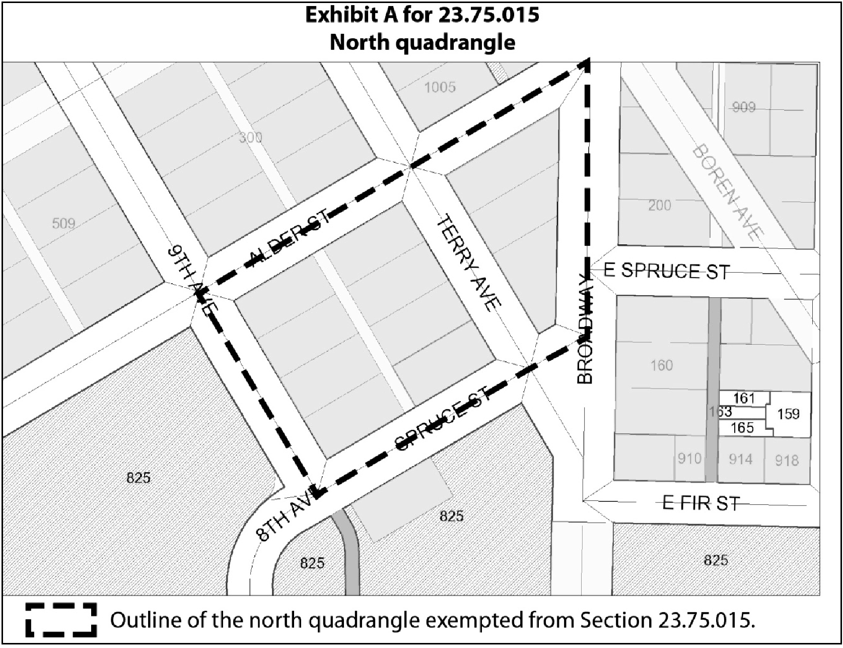
This Section 23.75.015 applies to the entire MPC-YT zone except for:
1.
the land identified as the north quadrangle in Exhibit A for 23.75.015, for which the whole of this Chapter 23.75 except for this Section 23.75.015 will apply on and following the effective date of this ordinance; and
2.
renovations and additions to the existing steam plant building in Block 2, for which the provisions of Chapter 23.45 applicable to property zoned LR3 shall apply instead of this Chapter 23.75, regardless of whether or not an approved final plat has been recorded.
B.
Except as otherwise provided in subsection 23.75.015.C, Part 2 and Part 3 of Chapter 23.75 shall not be applied for purposes of a land use decision other than a Type III decision unless, as of the date of that land use decision:
1.
there has been recorded, after January 1, 2012, an approved final plat of subdivision that includes the property for which the land use decision is made; and
2.
the Director of Transportation has filed with the City Clerk a certificate confirming that the City has accepted dedications, in a recorded plat or otherwise, establishing streets as necessary to complete, substantially as depicted in Exhibit A for 23.75.020, at least the portions of the streets that include or abut any part of the block where property subject to the decision is located and that are necessary to connect those portions to the improved street grid in each direction.
C.
Part 2 and Part 3 of Chapter 23.75 may be applied for purposes of a Type I or Type II land use decision for one building on the block bounded by Spruce Street, 8 th Avenue, Yesler Way, and Broadway Avenue, if the Director determines as a Type I decision that the proposed development does not interfere with the conceptual block and street configuration shown in Exhibit A for 23.75.020.
D.
If, pursuant to subsection 23.75.015.B, Part 2 and Part 3 of Chapter 23.75 are not applied for purposes of a land use decision, the provisions of Chapter 23.45 that apply to property zoned LR3 shall be applied instead.
E.
Uses and structures established pursuant to subsections 23.75.015.C and 23.75.015.D are included for purposes of application of aggregate limits to proposed development under Part 2 and Part 3 of Chapter 23.75 and allocations of those limits to lots under Section 23.75.040.
F.
The intent of this Section 23.75.015 is that all of Chapter 23.75 be in effect, for purposes of Section 23.76.026 and any other "vesting" laws or ordinances, as to all property in the MPC-YT zone, both before and after the events described in subsections 23.75.015.B.1 and 23.75.015.B.2.
(Ord. 124378, § 72, 2013; Ord. 123963, § 26, 2012.)
23.75.020 - Definitions
A.
Scope and applicability
1.
General rule. The terms set forth in quotation marks in this Section 23.75.020, when used in this Chapter 23.75, have the meanings set forth unless the context otherwise requires.
2.
Definitions in Chapter 23.84A. For purposes of this Chapter 23.75, definitions in this Chapter 23.75 supersede any definitions of the same terms in Chapter 23.84A.
B.
Defined terms
"Access drive" means a vehicle access easement providing access to two or more lots and meeting the requirements of Section 23.53.025.
"Affordable housing" means replacement units, 60% AMI units, and 80% AMI units, not existing as of January 1, 2012, provided to achieve increased residential floor area under Table A for 23.75.085. For purposes specific to affordable housing, references in this Chapter 23.75 to "household" mean a "family" according to 24 CFR Section 5.403 or successor provision, and each family's "income" is determined according to 24 CFR Section 5.609 or successor provision, unless otherwise approved in writing by the Director of Housing.
"Base setback" means the minimum setback required, if any, for the portion of a façade between zero and 50 feet in height.
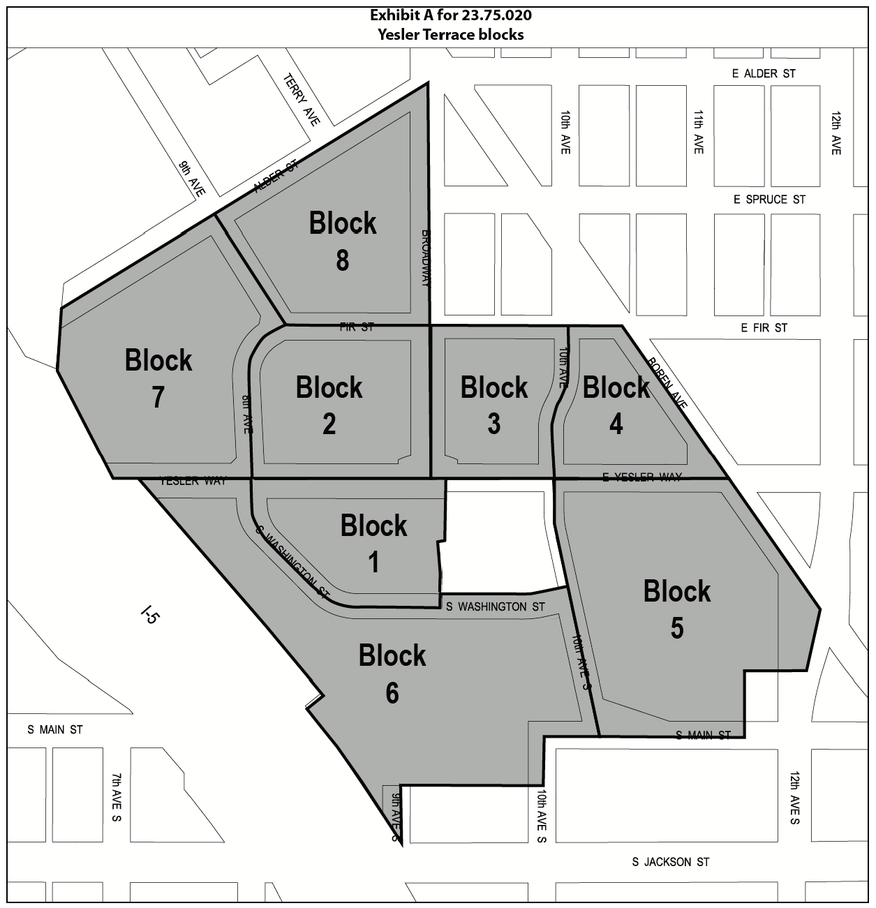
"Block" means one of the areas identified with a block number in Exhibit A for 23.75.020. Block margins align with the margins of the MPC-YT zone; with street centerlines of Yesler Way, E. Yesler Way, Broadway, 8 th Ave., 9 th Ave., and 10 th Ave; the centerline of E. Fir Street projected westerly from Broadway, as shown; the centerline of S. Washington Street, as shown; and the centerline of 10 th Ave S., between E. Yesler Way and S. Main St., as shown.
"Boundary" means any of the following, and for purposes of development standards means whichever of the following is closest to a given side of a structure: a lot line; the margin of an access drive; the margin of a pedestrian pathway; or the margin of a park that is open to the public.
"Build-to line" means any of the boundaries identified as build-to lines in Section 23.75.140.
"Certificate of occupancy" means the first certificate of occupancy issued by the City for a structure, whether temporary or permanent.
"Highrise structure" means a structure that exceeds 85 feet in height, as measured pursuant to Section 23.86.006.
"Non-highrise structure" means a structure that is not a highrise structure.
"Pedestrian pathway" means an area defined by a final plat or recorded permanent easement, with no horizontal dimension less than 32 feet at any point, that (1) includes a portion subject to a public easement, allowing pedestrian access from one side of a block to another side of the same block, and not allowing motor vehicle use except for emergency or maintenance vehicles and except that a pedestrian pathway may intersect an access drive; and (2) outside of the public easement portion, is dedicated on terms that do not allow any gross floor area of a structure, but may allow structures such as sign kiosks, arbors, fences, and freestanding walls, and may allow projections from structures such as decks or patios.
"Regulated façade" means the portion of a façade, if any, that is adjacent to a street, a park that is open to the public, a pedestrian pathway, or an access drive; is oriented at less than a 90 degree angle to the boundary that is closest to the facade; and is not separated from that boundary by any part of another lot, or any structure except a retaining wall, deck, freestanding wall, fence, ramp, solar collector, or sign.
"Replacement unit" means one of the first 561 new or renovated units constructed in the Yesler Terrace redevelopment area, to be occupied by or reserved for Yesler Terrace residents who must relocate due to demolition and construction or households with incomes at initial occupancy no higher than 30 percent of median income, subject to requirements of subsection 23.75.085.D.
"Residential floor area" means gross floor area in residential use plus gross floor area of live-work units, except that it does not include any floor area of residential structures existing as of January 1, 2012.
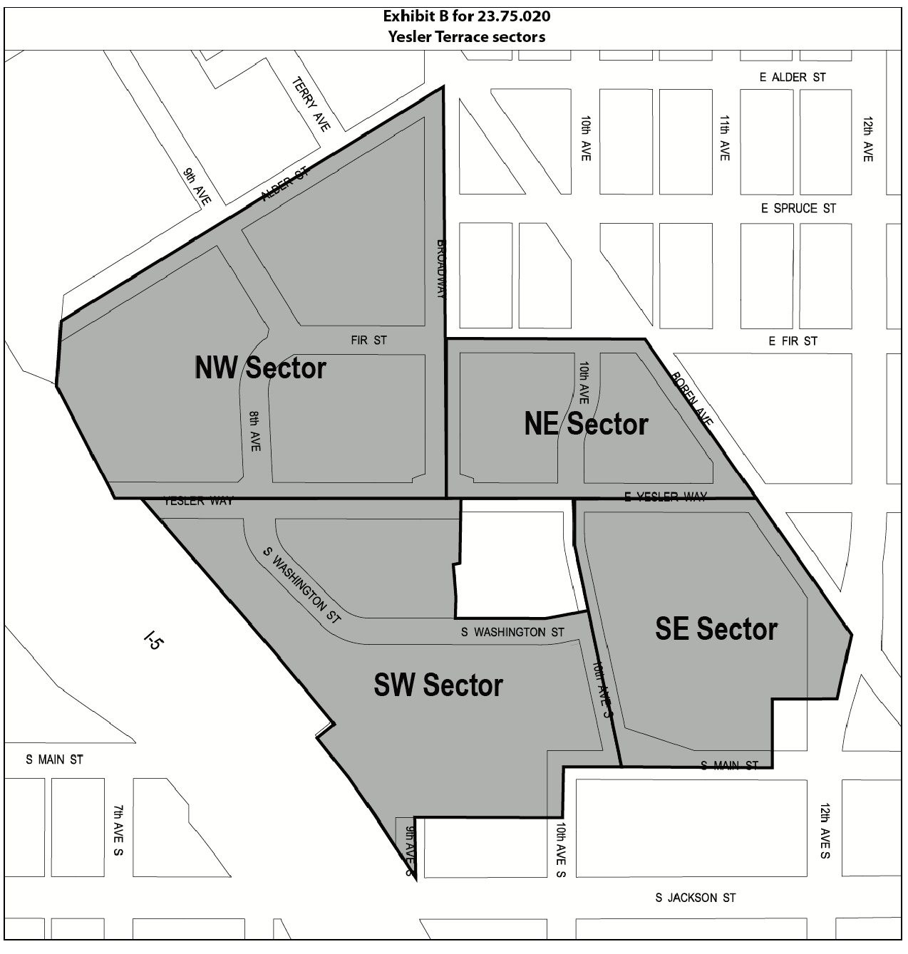
"Sector" means one of the areas identified in Exhibit B for 23.75.020. Sector margins align with the margins of the MPC-YT zone, with street centerlines of Yesler Way, E. Yesler Way and Broadway, as shown, and with the border between Block 5 and Block 6.
"Setback condition" for any location means the circumstance determining the setbacks that may be required under Section 23.75.140, including the type of special setback area or the type of boundary closest to a façade of a structure, as applicable.
"Smallest bounding rectangle" means the smallest rectangle that can be drawn in plan view to enclose all portions of a highrise structure located above 85 feet.
"Yesler Terrace redevelopment area" means the MPC-YT zone as well as the area bounded by Boren Ave, E. Yesler Way, 14 th Ave., and E. Fir Street.
"60% AMI unit" means a dwelling unit other than a replacement unit or 80% AMI unit, to be occupied by or reserved solely for households with incomes at initial occupancy no higher than 60 percent of median income, subject to requirements of subsection 23.75.085.D.
"80% AMI unit" means a dwelling unit other than a replacement unit or 60% AMI unit, to be occupied by or reserved solely for households with incomes at initial occupancy no higher than 80 percent of median income, subject to requirements of subsection 23.75.085.D.
(Ord. 126855, § 65, 2023; Ord. 124378, § 73, 2013; Ord. 123963, § 26, 2012.)
23.75.040 - Aggregate standards and allocations
A.
Definitions. For purposes of this Section 23.75.040:
1.
"Limit" means one of the following:
a.
the maximum residential floor area that may be located in the MPC-YT zone, as determined for each tier under Section 23.75.085;
b.
the maximum residential floor area that may be located in each sector, as set forth in Section 23.75.085;
c.
the maximum nonresidential floor area, by category of use, that may be located in the MPC-YT zone, as determined under Section 23.75.090;
d.
the maximum number of highrise structures that may be located in a sector, as set forth in Section 23.75.120;
e.
in certain blocks, the number of highrise structures for which alternative development standards may be elected, as set forth in Section 23.75.120;
f.
the maximum number of parking spaces, in addition to those based on a ratio to residential units, that that may be located within the NW sector without a special exception, as set forth in Section 23.75.180;
g.
the maximum number of parking spaces, in addition to those based on a ratio to residential units and those allowed as described in subsection 23.75.040.A.1.f, that may be located within the NW sector with a special exception, as set forth in Section 23.75.180; and
h.
the maximum number of surface parking spaces in a block, as set forth in Section 23.75.180.
2.
"Allocation document" means a recorded final plat, declaration or covenant, as it may be established or amended in accordance with subsection 23.75.040.C; is signed by all owners of record of lots subject to the allocation document; provides that pursuant to this Section 23.75.040, the lots are combined for the purposes of that limit except to the extent that the limit is allocated to specific lots as approved by the Director; provides for possible reallocation among lots by agreement of the owners of only those lots; and provides notice that the current allocation to any lot must be determined from the records of the Department. The same plat, declaration or covenant may include multiple allocation documents for different limits and may create different combined lots for different limits.
3.
"Combined lot" means two or more lots that have been combined for purposes of any limit under an allocation document, and that remain so combined under subsection 23.75.040.D.3.
4.
"Formula parking allowance" means the maximum number of parking spaces allowed in a sector based on ratios to developed non-parking uses under Section 23.75.180.
B.
General rules. Development on any lot in the MPC-YT zone shall not exceed, in any quantity subject to a limit listed in subsection 23.74.040.A.1, that portion of the limit allocated to that lot in accordance with this Section 23.75.040. The Director shall apply each limit by requiring as a condition of permit approval that a lot have a sufficient unused allocation of that limit according to this Section 23.75.040 for the proposed development. The same use or structure may require sufficient allocations of more than one of the limits. A permit for development on a lot may not be denied based on a limit if the lot has a sufficient, valid, unused allocation of the limit under this Section 23.75.040.
C.
Allocation document.
1.
The owners of all lots that are subject to a limit, whether or not contiguous, and upon which no part of the limit has yet been used, may combine the lots for purposes of that limit pursuant to an allocation document approved by the Director, and may then allocate the limit among those lots as the owners may elect, subject to approval by the Director under this subsection 23.75.040.C.
2.
The Director shall approve an allocation document only if the Director determines, as a Type I decision, that the document is consistent with this Chapter 23.75 and provides for an allocation process that will specify the allocations of one or more limits consistent with this Chapter 23.75 in a manner that will maintain consistency with those limits and allow the Director to determine the validity of each allocation to be made. To facilitate administration of this Chapter 23.75, the Director may establish, by rule, procedural requirements for allocation documents and allocations under them, and may approve or disapprove provisions in allocation documents for limits or conditions on allocations or reallocations in addition to those required.
3.
Any amendment to an allocation document is effective only if signed by all owners of record of all property subject to the allocation document and only if the Director approves the allocation document as amended, as a Type I decision, based on a determination that it is consistent with the requirements for an allocation document and with allocations previously made.
4.
Unless initial allocations to each lot are specified in the allocation document, in order to establish the initial allocation to the first lot to which an allocation is made, the process must require written approval of the owners of all lots initially combined. In order to establish the initial allocation to each other lot, the written approval of the owners of all remaining lots combined for purposes of that limit is required as provided in subsection 23.75.040.D.3.
D.
Allocations of limits.
1.
Unless all lots subject to a limit have been combined pursuant to subsection 23.75.040.C for purposes of a limit, each lot has an allocation of that limit in the same proportion as the lot area bears to the area of all lots subject to the limit, rounded down to the nearest integer, which may be zero. For purposes of this subsection 23.75.040.D.1, the area of every lot subject to a limit and the total area of all lots subject to the limit is determined as of the date when the first Master Use Permit application is submitted for the use of any part of the limit on any lot, so that the allocations of the limit to all lots are then fixed, subject to any reallocations under subsection 23.75.040.D.7.
2.
If lots are combined pursuant to subsection 23.75.040.C for purposes of a limit, then
a.
before any allocation is made to one of those lots pursuant to this Section 23.75.040, the combined lot has an undivided allocation of that limit equal to the entire limit; and
b.
as allocations to specific lots are made pursuant to this Section 23.75.040, the undivided allocation of that limit to the remaining combined lot is reduced by each amount so allocated.
3.
If, after a lot is combined with one or more other lots pursuant to subsection 23.75.040.C for the purposes of a limit, an allocation of that limit is made to the lot in accordance with subsection 23.75.040.D.5, then the lot has the allocation so approved, and is no longer part of a combined lot for purposes of that limit. The lot may remain eligible to receive additional allocations, transfer an unused portion of its allocation to other lots, or both, pursuant to the allocation document and subject to any applicable rules issued by the Director.
4.
When a specific lot has been made part of a combined lot and no allocation of the limit to the specific lot has been approved by the Director, no development of that lot requiring an allocable portion of that limit is permitted, except that if the combined lot is a single development site for purposes of an application, then the limit is for the combined lot as determined under subsection 23.75.040.D.2.
5.
Pursuant to processes established in an allocation document consistent with 23.75.140.C, the portion of a limit allocated to a lot shall be initially established, and may be modified, in a manner that maintains consistency with the limit, in each case effective upon approval of the allocation or reallocation by the Director, as a Type I decision. The Director shall approve the allocation or reallocation under processes established in an allocation document, provided that:
a.
the owners of the lots affected have provided written approval; and
b.
the Director determines that the proposed allocation or reallocation is consistent with this Chapter 23.75 and with any relevant applications then pending, and with requirements of form and procedure established by the Director, and that any special conditions in the allocation document, are satisfied.
6.
The allocation document may provide for reallocations among lots to which initial allocations have been made, with the written approval of the owners of the lots affected. A limit may not be reallocated in any manner that would create a nonconformity, or increase the extent of any nonconformity, based on established uses or structures, or based on any development for which a permit has been issued or is pending.
7.
If lot lines are modified or new lots are created, then except to the extent otherwise provided in an allocation document or pursuant to agreements among owners approved by the Director, each new or modified lot shall have a share of each of the total allocations previously applicable to all lots affected by the modification of lot lines or creation of the new lots, in the same proportion as the area of that lot bears to the area of all such lots, except that the allocation to any new or modified lot shall be adjusted to the extent required so as not to create a nonconformity, or increase the extent of any existing nonconformity. To the extent necessary to offset any disproportionate allocation required to avoid a nonconformity, allocations to other new or modified lots shall be reduced in proportion to their respective lot areas. All reallocated limits that otherwise would include fractions shall be rounded down to the next integer. For purposes of adjustment of allocations described in this subsection 23.75.040.D.7, a combined lot then existing for any limit is treated as a single lot for that limit.
E.
Formula parking allowance transfers.
1.
The portion of the formula parking allowance for a sector permitted on any lot is that portion attributable to the non-parking uses developed on that lot, except as permitted in this subsection 23.75.040.E.
2.
To the extent that the amount of parking existing, established by permit, and subject to pending applications for permits on a lot is less than the amount allowed under this subsection 23.75.040.E, the owner of that lot may transfer formula parking credits to another lot in the sector, in a manner prescribed by the Director.
3.
The transfer of formula parking credits increases the number of parking spaces permitted on the lot receiving the transfer and reduces the number of spaces permitted on the lot from which the transfer is made by the same amount.
(Ord. 123963, § 26, 2012.)
23.75.050 - Permitted uses
A.
Except as provided in this Section 23.75.050, Section 23.75.060, and Section 23.75.070, all uses are permitted outright, both as principal uses and as accessory uses.
B.
Permitted uses in Block 1 are restricted to:
1.
Parks and accessory uses, including farmers markets or crafts markets or displays; and
2.
Eating and drinking establishments and general sales and service uses, limited to one story and no more than 1,500 square feet of gross floor area for all such uses. No more than 700 square feet of accessory outdoor seating is permitted.
(Ord. 123963, § 26, 2012.)
23.75.060 - Prohibited uses
The following uses are prohibited as both principal and accessory uses, except as provided in this Section 23.75.060 or Section 23.75.070:
A.
Adult cabarets, adult motion picture theaters, and adult panorams;
B.
Animal shelters and kennels;
C.
Animal husbandry;
D.
Communication utilities, major;
E.
Drive-in businesses;
F.
General manufacturing uses;
G.
Heavy manufacturing uses;
H.
High-impact uses;
I.
Jails;
J.
Mobile home parks;
K.
Outdoor storage, except for outdoor storage associated with community gardens, florists, and horticulture uses;
L.
Recycling;
M.
Sales and services, heavy, except for major durables retail sales;
N.
Solid waste management;
O.
Storage as a principal use;
P.
Transportation facilities, air;
Q.
Vehicle storage and maintenance, except if fully enclosed and used exclusively by Seattle Housing Authority vehicles;
R.
Warehouses and mini-warehouses; and
S.
Work release centers.
(Ord. 123963, § 26, 2012.)
23.75.070 - Conditional uses
A.
Conditional use criteria.
1.
All applications for conditional uses are subject to the procedures described in Chapter 23.76.
2.
A conditional use is not allowed if it would be materially detrimental to the public welfare or injurious to property in the zone or vicinity in which the property is located.
3.
In authorizing a conditional use, the Director may impose requirements or conditions to avoid or mitigate adverse impacts.
4.
The Director shall deny a conditional use if the Director determines that the negative impacts cannot be mitigated satisfactorily.
B.
The Director may permit the following uses as administrative conditional uses if the provisions of this Section 23.75.070 are met:
1.
Animal husbandry, as an accessory use only;
2.
District energy supply facilities;
3.
Recycling, as an accessory use only;
4.
Sales and services, automotive; and
5.
Solid waste management, as an accessory use only.
(Ord. 123963, § 26, 2012.)
23.75.080 - Street-level uses
A.
Nonresidential uses are not allowed to occupy, in the aggregate, more than 20 percent of the total street-level street-facing façades, along S. Washington Street, of all structures on a lot, except that abutting lots may be combined and treated as one lot for purposes of this subsection 23.75.080.A pursuant to an agreement among the lot owners, satisfactory to the Director and recorded with the King County Recorder.
B.
Any lot abutting any of the following sides of street segments, illustrated in Exhibit A for 23.75.080, is subject to requirements in subsection 23.75.080.C:
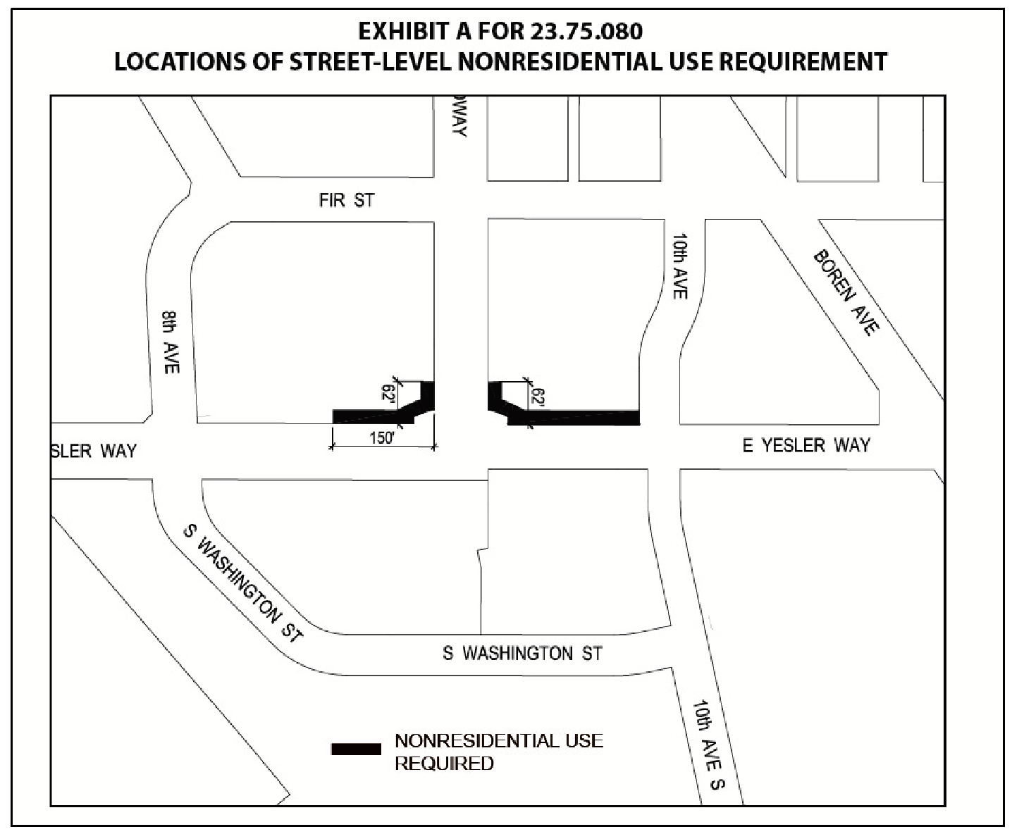
1.
Both sides of Broadway, from Yesler Way to 62 feet north of the north margin of Yesler Way;
2.
The north side of East Yesler Way from the east margin of Broadway to the west margin of 10 th Avenue; and
3.
The north side of Yesler Way from the west margin of Broadway to 150 feet west of the west margin of Broadway.
C.
Along the street segments identified in subsection 23.75.080.B, one or more of the following uses are required along at least 80 percent of the street-level, street-facing façade of each structure. The usable space of these uses must have a minimum depth of 30 feet.
1.
All institutions except hospitals and private clubs;
2.
Eating and drinking establishments;
3.
General sales and services;
4.
Human service uses;
5.
Indoor sports and recreation;
6.
Lodging uses;
7.
Major durables retail sales;
8.
Medical services;
9.
Office designated for use by Seattle Housing Authority for redevelopment planning or leasing purposes; or
10.
Theaters and spectator sport facilities.
(Ord. 123963, § 26, 2012.)
23.75.085 - Residential floor area limits; affordable housing incentive
A.
Purpose. The provisions of this Section 23.75.085 are intended to implement an affordable housing incentive as authorized by RCW 36.70A.540.
B.
Findings. Pursuant to the authority of RCW 36.70A.540, the City finds that:
1.
The phased redevelopment of the properties in the MPC-YT zone addresses the need for increased residential development to achieve local growth management and housing policies; and
2.
The terms of the affordable housing incentive in this Section 23.75.085 recognize that, for affordable housing not receiving federal subsidies, the higher income levels specified for 60% AMI units and 80% AMI units, rather than the level stated for rental housing units in the definition of "low-income households" in RCW 36.70A.540, are needed to address local housing market conditions.
C.
The aggregate residential floor area limit for built and permitted development on all lots within the MPC-YT zone is established in Table A for 23.75.085 and subject to the following conditions:
1.
The aggregate residential floor area limit is increased in stages, referred to as "tiers," when affordable housing is provided in accordance with the terms of this Section 23.75.085 in amounts sufficient to satisfy the conditions for the next tier according to Table A for 23.75.085.
2.
The Tier 1 limit is the base, so no affordable housing needs to be provided in order for aggregate residential floor area to reach the Tier 1 limit.
3.
If the total amount of constructed or permitted floor area reaches the applicable tier limit, but affordable housing production conditions have not been satisfied, no further building permits for residential floor area may be issued except for replacement units, 60% AMI units, or 80% AMI units. In counting total permitted residential floor area, projects with expired or cancelled permits shall not be included.
4.
After the maximum residential floor area allowed has been increased to Tier 4, no Master Use Permit for a development including residential floor area shall be issued unless the development application includes a number of 80% AMI units equal to 4.5 percent of the total number of units in the application that are not either replacement units or 60% AMI units.
Table A for 23.75.085
Maximum floor area limits for residential uses based on affordable housing production
1
D.
To count toward the conditions to a higher tier under Table A for 23.75.085, affordable housing shall be committed under recorded covenants or instruments, acceptable to the Director of Housing, to satisfy the following requirements:
1.
Term. The affordable housing shall serve only income eligible households for replacement units, 60% AMI units, or 80% AMI units, as defined in Section 23.75.020, for a minimum of 50 years from the date when the affordable housing becomes available for occupancy as determined by the Director of Housing.
2.
Affordability. Units must be committed to affordability as follows:
a.
Except as permitted in subsection 23.75.085.D.2.e, for replacement units, monthly rent, including basic utilities, shall be as allowed under the 1937 U.S. Housing Act, as amended, and agreements between the Seattle Housing Authority and the U.S. Department of Housing & Urban Development (HUD) and, for City-funded replacement units, agreements between the Seattle Housing Authority and The City of Seattle. Rent may increase in proportion to household income for qualifying tenants provided that rent shall not exceed 30 percent of 80 percent of median income. For purposes of this Section 23.75.085, Yesler Terrace residents who are eligible to return pursuant to a relocation plan adopted by the Seattle Housing Authority shall be deemed to have met initial occupancy requirements.
b.
Except as permitted in subsection 23.75.085.D.2.e, for 60% AMI units, monthly rent, including basic utilities, shall not exceed 30 percent of 60 percent of median income.
c.
For 80% AMI units that are rental housing, monthly rent, including basic utilities, shall not exceed 30 percent of 80 percent of median income.
d.
For 80% AMI units that are offered for sale, the initial sale price shall not exceed an amount determined by the Director of Housing to be affordable to a household with an income, at the time of initial occupancy by the household, no higher than 80 percent of median income. The unit shall be subject to recorded covenants or instruments satisfactory to the Director of Housing providing for limits on sale and resale prices according to Section 23.75.020 and this Section 23.75.085 for at least 50 years. The Director of Housing is authorized to adopt by rule the method of determining affordability, including estimated monthly housing costs and requirements relating to down payment amount and homebuyer contributions.
e.
The Director of Housing is authorized to amend covenants to adjust affordability and income limits up to a maximum of 30 percent of 80 percent of median income if the Director of Housing determines that:
1)
In the case of replacement units, a reduction in federal operating subsidies has made such funding insufficient to maintain the replacement units for households with incomes at or below 30 percent of median income;
2)
In the case of 60% AMI units, after 40 years from initial occupancy of a building, rent levels are insufficient to operate and maintain the units or to meet any required debt coverage ratios as required by financing;
3)
The number of units with adjusted affordability has been minimized to the extent practical, and
4)
One or more agreements are entered into between the housing owner and the Director of Housing committing the housing owner(s) to new affordability and occupancy requirements effective when replacement units and/or 60% AMI units are vacated and available for occupancy by new tenants.
3.
Size. If provided in a development permitted under a single master use permit that includes dwelling units other than affordable housing, the average net unit area, measured according to subsection 23.86.007.B, of the units provided to satisfy requirements of this Section 23.75.085 shall be no smaller than the average net unit area of the total units in the development.
4.
Location. Affordable housing must be located within the Yesler Terrace redevelopment area. No more than 190 of the replacement units shall be located east of Boren Avenue. A minimum of 50 replacement units shall be located in at least five of the eight blocks west of Boren Avenue. When provided within a development permitted under a single master use permit that includes dwelling units other than affordable housing, the affordable housing shall generally be distributed throughout the development.
5.
Reports. Periodically as may be required by the Director of Housing, but no less than annually, the owner of the affordable housing shall submit to the Office of Housing a written report demonstrating compliance with and housing outcomes of this Section 23.75.085. The report shall include required information and supporting documentation, verified upon the owner's oath or affirmation and in a form prescribed by the Office of Housing. The Director of Housing is authorized to assess a late fee of $50 per day, which shall accrue until the report is submitted, starting 14 days from the date of the Office of Housing's notice that the report is overdue. For ownership affordable housing, the applicant or third-party stewardship entity, as applicable, must comply with reporting requirements of this subsection 23.75.085.D.5.
6.
Compliance monitoring fees
a.
Rental affordable housing. The owner of rental affordable housing shall pay the Office of Housing an annual fee of $190 per affordable housing unit for the purpose of monitoring compliance according to this Section 23.75.085.The annual fee shall automatically adjust annually on March 1, starting in 2024, by an amount in proportion to the increase, if any, for January 1 through December 31 of the prior calendar year, in the Consumer Price Index, All Urban Consumers, Seattle-Tacoma-Bellevue, WA, All Items (1982-1984=100), as determined by the U.S. Department of Labor, Bureau of Labor Statistics, or successor index, unless the Director of Housing determines that a lower fee covers the cost of monitoring compliance.
b.
Ownership affordable housing. The owner of each ownership affordable housing unit shall pay to the Office of Housing or third-party stewardship entity, as applicable, an annual fee payable in 12 equal payments for the purpose of monitoring compliance with this Section 23.75.085. The fee shall be established by the Director of Housing by rule.
E.
No other restrictions for 80% AMI units; exceptions
1.
Except as permitted in subsection 23.75.085.E.2, 80% AMI units provided according to this Section 23.75.085 must be different than restricted units provided for any other reason.
2.
For purposes of this subsection 23.75.085.E, 80% AMI units may be the same units as provided to satisfy conditions of the following subsidies:
a.
Discounted land sales prices;
b.
Washington State Housing Finance Commission bonds and 4-percent low-income housing tax credits; and
c.
The first 12 years of a property tax exemption pursuant to Chapter 5.73.
F.
Production
1.
A replacement unit, 60% AMI unit, or 80% AMI unit shall count for purposes of Table A for 23.75.085 when the affordable housing is subject to recorded covenants or instruments that conform to this Section 23.75.085 and are satisfactory to the Director of Housing in form, content, and priority. Any unit or units of housing provided as a condition to bonus floor area pursuant to any Land Use Code section other than 23.75.085 shall not count for purposes of Table A for 23.75.085.
2.
Units other than replacement units, 60% AMI units, and 80% AMI units shall count for purposes of Table A for 23.75.085 when a Master Use Permit for construction of those units has been issued, unless and until either:
a.
The Master Use Permit decision is cancelled before the Master Use Permit is issued, or the Master Use Permit issued pursuant to such decision expires or is cancelled, without the highrise structure having been constructed; or
b.
A ruling by a hearing examiner or court of competent jurisdiction reversing or vacating such decision, or determining such decision or the Master Use Permit issued thereunder to be invalid, becomes final and no longer subject to judicial review.
G.
Tier determination. Upon application by any owner within the MPC-YT zone, the Director may make a Type I decision as to the residential floor area tier in effect.
H.
Rules. The Director and the Director of Housing are authorized jointly to adopt rules to interpret and implement the provisions of this Section 23.75.085, in addition to rules that may be adopted by the Director of Housing independently as authorized in this Section 23.75.085.
I.
Distribution of residential floor area limits by sector. Table B for 23.75.085 establishes residential maximum floor area limits by sector. The sum of the sector allocations exceeds the maximum established for the entire zone, but this subsection 23.75.085.I does not allow the total amount of residential floor area in all sectors combined to exceed the limit in effect under Table A for 23.75.085.
Table B for 23.75.085
Distribution of residential floor area
J.
Floor area subject to the limits in this Section 23.75.085 is all residential gross floor area except for accessory parking and floor area in residential structures existing as of January 1, 2012.
K.
Fees. The applicant for a project that includes 80% AMI units according to this Section 23.75.085 shall pay housing review fees according to Section 22.900G.015.
(Ord. 126855, § 66, 2023; Ord. 125603, § 67, 2018; Ord. 123963, § 26, 2012.)
23.75.090 - Nonresidential floor area limits
A.
Nonresidential floor area. Except as provided in subsection 23.75.090.B, the aggregate nonresidential floor area limits for built and permitted development on all lots within the MPC-YT zone are as follows:
1.
Combined floor area for office, medical services, and lodging shall not exceed 900,000 square feet.
2.
Combined floor area for all other nonresidential uses shall not exceed 150,000 square feet.
B.
Floor area subject to the limits in this Section 23.75.090 is all nonresidential gross floor area except:
a.
Community clubs or centers;
b.
Child care centers;
c.
Family support centers;
d.
Human service uses;
e.
Accessory parking;
f.
Floor area below grade; and
g.
Floor area within landmark structures existing and designated as of January 1, 2012.
(Ord. 123963, § 26, 2012.)
23.75.095 - Maximum size of use
A.
Size limits in this Section 23.75.095 apply to the total size of a business establishment, except that if a business establishment includes more than one principal use, size limits apply separately to the size of each principal use that the business establishment proposes within the MPC-YT zone.
B.
Sales and services uses are limited to no more than 25,000 square feet of gross floor area per business establishment.
C.
In each sector except the NW sector, office and lodging are limited to no more than 25,000 square feet of gross floor area per business establishment.
D.
In each sector except the NW Sector, medical services are limited to no more than 15,000 square feet of gross floor area per business establishment, except that as a special exception pursuant to Chapter 23.76 the Director may permit a single business establishment containing medical services uses up to 25,000 square feet of gross floor area, based on consideration of the following factors:
a.
Whether the amount of medical services uses existing and proposed in the vicinity would result in an area containing a concentration of medical services that compromises the neighborhood's mixed use character; and
b.
Whether medical service uses would disrupt a continuous commercial street front, particularly of general sales and services uses, or significantly detract from an area's overall neighborhood-serving commercial character.
(Ord. 123963, § 26, 2012.)
23.75.100 - Structure height
A.
Structure height is not allowed to exceed the applicable height limit established in Exhibit A for 23.75.100. In areas shown in Exhibit A for 23.75.100 where the height limit is "85/" followed by a second number, 85 feet is the applicable height limit for non-highrise structures. The number following the "/"is the applicable height limit for highrise structures.
B.
The number, distribution, and maximum gross floor area per story of highrise structures are restricted according to Section 23.75.120.
C.
Structure height is measured pursuant to subsection 23.86.006.A, except in the view corridor height restriction areas depicted in Exhibit A for 23.75.100, where solely for the purposes of this Section 23.75.100 and Section 23.75.110, structure height is measured from an elevation above the vertical datum for Seattle under Section 1.20.020.
D.
If a structure is within more than one of the areas designated on Exhibit A for 23.75.100, the height limits apply separately to the portions of the structure in each area.
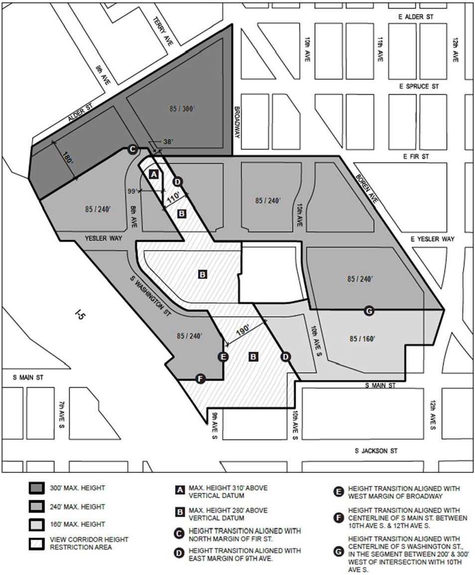
(Ord. 125781, § 6, 2019; Ord. 123963, § 26, 2012.)
23.75.110 - Rooftop features
A.
Flagpoles and religious symbols for religious institutions are exempt from height controls, except as regulated in Chapter 23.64, provided they are no closer to any lot line than 50 percent of their height above the roof portion where attached.
B.
Open railings, planters, skylights, clerestories, parapets and firewalls may extend 4 feet above the applicable height limit set in Section 23.75.100.
C.
Rooftop solar collectors may extend up to 10 feet above the applicable height limit set in Section 23.75.100.
D.
The following rooftop features may extend above the applicable height limit set in Section 23.75.100 if none of those features extends more than 15 feet above the applicable height limit set in Section 23.75.100 and the combined total coverage of all those features that extend above the applicable height limit and any elevator penthouse does not exceed 30 percent of the roof area, or 35 percent of the roof area if the total includes screened or enclosed mechanical equipment:
1.
Stair penthouses that are not also elevator penthouses;
2.
Mechanical equipment;
3.
Play equipment and open-mesh fencing that encloses it, if the fencing is at least 5 feet from the roof edge;
4.
Chimneys;
5.
Sun and wind screens, and similar weather protection features such as eaves or canopies extending from rooftop features;
6.
Penthouse pavilions for the common use of residents;
7.
Greenhouses and solariums;
8.
Wind-driven power generators;
9.
Covered or enclosed common amenity areas; or
10.
Minor communication utilities and accessory communication devices, except that height is regulated according to the provisions of Section 23.57.011.
E.
Subject to the roof coverage limits in subsection 23.75.110.D, height exceptions for elevator penthouses are as follows:
1.
Within the view corridor height restriction area depicted in Exhibit A for 23.75.100, an elevator penthouse may extend above the applicable height limit by up to 15 feet.
2.
Outside the view corridor height restriction area depicted in Exhibit A for 23.75.100, an elevator penthouse may extend above the applicable height limit by up to 25 feet. If the elevator provides access to a highrise rooftop that includes residential amenity area or a green roof, the penthouse may extend above the applicable height limit by up to 35 feet.
3.
A stair penthouse may be the same height as an elevator penthouse if the elevator and the stairs are located within a common penthouse.
F.
Greenhouses and solariums are permitted to extend 15 feet above the applicable height limit, if, together with all features gaining additional height through subsections 23.75.110.D and 23.75.110.E, they do not exceed 60 percent of the roof area.
G.
To protect solar access for property to the north, the applicant shall locate the rooftop features listed in this Section 23.75.110 that extend above the applicable height limit at least 10 feet from the northerly edge of the roof, except that stair and elevator penthouses may extend to the edge of the roof for a total length along the edge of not more than 30 feet.
H.
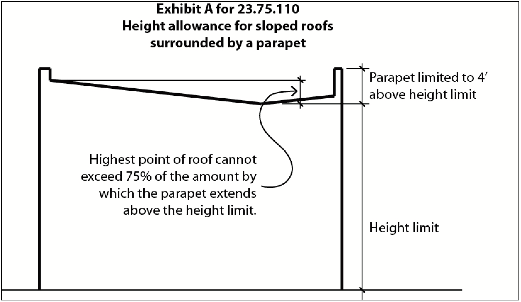
Portions of a sloped roof that are completely surrounded by a parapet may exceed the applicable height limit to allow drainage, provided that the highest point of the roof does not exceed the applicable height limit in Section 23.75.100 by more than 75 percent of the amount by which the parapet extends above the height limit. See Exhibit A for 23.75.110.
I.
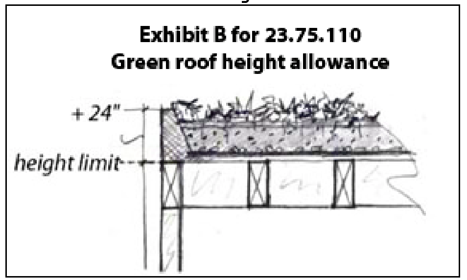
For any structure with a green roof, up to 24 inches of additional height above the applicable height limit in Section 23.75.100 is allowed to accommodate the structural requirements, roofing membranes, and soil for that green roof. See Exhibit B for 23.75.110.
(Ord. 126600, § 17, 2022; Ord. 123963, § 26, 2012.)
23.75.120 - Limitations on highrise structures
A.
Number and distribution of highrise structures. Table A for 23.75.120 establishes limits on the number and distribution of highrise structures by sector. No highrise structures are allowed in Block 1.
Table A for 23.75.120
Number and distribution of highrise structures
B.
Maximum gross floor area per story, by block as shown in Exhibit A for 23.75.020.
1.
In Blocks 2, 3, and 4:
a.
If structure height is 160 feet or less, each story wholly or in part above 85 feet is limited to a maximum of 15,000 square feet of gross floor area.
b.
If structure height exceeds 160 feet, each story wholly or in part above 85 feet is limited to a maximum of 11,000 square feet of gross floor area.
2.
In Blocks 5 and 6:
a.
If structure height is 125 feet or less, each story wholly or in part above 85 feet is limited to a maximum of 15,000 square feet of gross floor area.
b.
If structure height exceeds 125 feet, each story wholly or in part above 85 feet is limited to a maximum of 11,000 square feet of gross floor area.
3.
Highrise structures in Blocks 7 and 8 are subject to the same standards that apply in subsection 23.75.120.B.1, except that one highrise structure on each of these two blocks is allowed to meet the following standards in lieu of those in subsection 23.75.120.B.1:
a.
If structure height is 125 feet or less, each story wholly or in part above 85 feet is limited to a maximum of 35,000 square feet of gross floor area.
b.
If structure height exceeds 125 feet, each story wholly or in part above 85 feet is limited to a maximum of 24,000 square feet of gross floor area.
C.
Highrise separation.
1.
All portions of a proposed highrise structure above 85 feet in height shall be separated horizontally from all portions of an existing highrise structure above 85 feet, whether on the same block or a different block, as follows and as illustrated in Exhibit A for 23.75.120:
a.
If the façade or smallest bounding rectangle of a proposed highrise structure does not overlap with the middle third of any façade of an existing highrise structure, or with the middle third of any side of the smallest bounding rectangle of an existing highrise structure, the minimum separation is 80 feet from all portions of the existing highrise structure.
b.
If the façade or smallest bounding rectangle of a proposed highrise structure does overlap with the middle third of any façade of an existing highrise structure, or with the middle third of any side of the smallest bounding rectangle of an existing highrise structure, the minimum separation is 120 feet from all portions of the existing highrise.
2.
For purposes of this subsection 23.75.120.C, an "existing highrise structure" is either:
a.
a highrise structure that is physically present; or
b.
a proposed highrise structure for which a Master Use Permit decision that includes approval of the highrise structure has been approved for issuance, unless and until either:
1)
the Master Use Permit decision is cancelled before the Master Use Permit is issued, or the Master Use Permit issued pursuant to such decision expires or is cancelled, without the highrise structure having been constructed; or
2)
a ruling by a hearing examiner or court of competent jurisdiction reversing or vacating such decision, or determining such decision or the Master Use Permit issued thereunder to be invalid, becomes final and no longer subject to judicial review.
(Ord. 123963, § 26, 2012.)
23.75.130 - Maximum width of regulated facade
Each regulated façade is limited to 240 feet in width, except for structures in Block 6 where an open space with a minimum width of 40 feet, measured parallel to the street, and a minimum depth of 30 feet separates a portion of the façade from the street, dividing the regulated facade into segments with a maximum width of 240 feet each.
(Ord. 123963, § 26, 2012.)
23.75.140 - Setbacks and projections
A.
General requirements and special setback areas
1.
Except as otherwise provided in this Section 23.75.140, minimum setbacks are required as follows:
a.
According to Exhibit A for 23.75.140 where no special setback condition identified in subsection 23.75.140.C, 23.75.140.D, or 23.75.140.E applies to the boundary; or
b.
According to Exhibit B for 23.75.140 where a special setback condition identified in subsection 23.75.140.C, 23.75.140.D, or 23.75.140.E applies to the boundary.
2.
If a location identified for a special setback condition in subsection 23.75.140.C, 23.75.140.D, or 23.75.140.E is described in reference to a park, access drive, pedestrian pathway, or other easement that has not been established by a final plat or recorded instrument at the time a permit decision is made, the applicable general minimum setback applies in that location rather than the special setback condition.
Exhibit A for 23.75.140
General Minimum Setbacks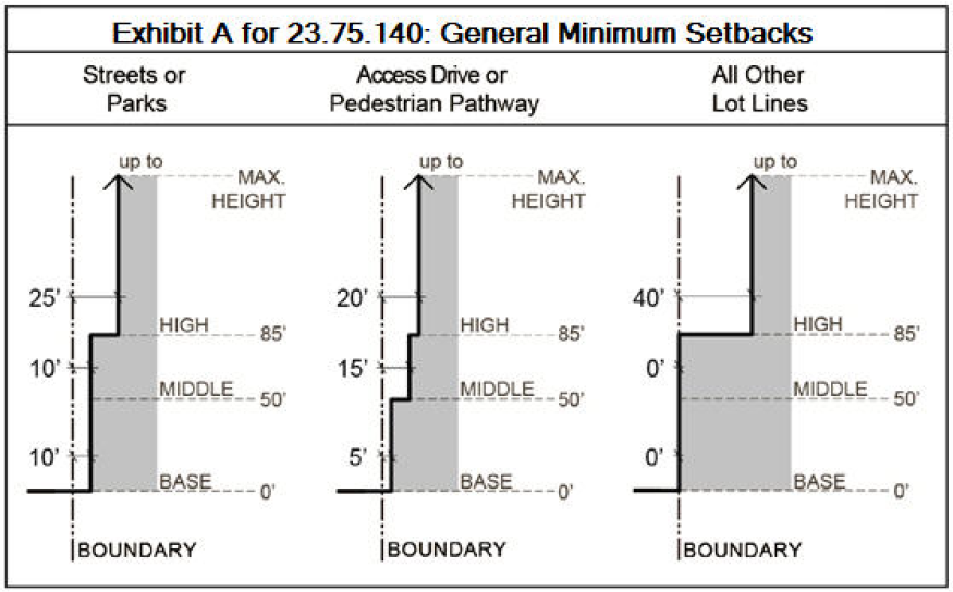
Exhibit B for 23.75.140
Special Setback Conditions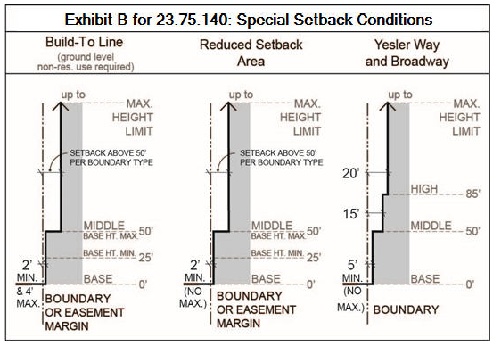
B.
The 10-foot minimum setback shown in Exhibit A for 23.75.140 from streets or parks open to the public is reduced to 7 feet for a residential structure that is partially separated from the street or park by a ground-floor-level courtyard that is at least 30 feet wide and 20 feet deep.
Exhibit C for 23.75.140
Locations of Special Setback Areas
C.
Build-to line
1.
The following locations, illustrated in Exhibit C for 23.75.140, are subject to this subsection 23.75.140.C:
a.
At the following street intersection locations, the build-to line extends 62 feet along street lot lines in both directions from the intersection of the margins of the street rights of way:
1)
the southwest and southeast corners of the intersection of Alder Street and 9 th Avenue;
2)
the southwest corner of the intersection of Alder Street and Broadway;
3)
the northwest and northeast corners of the intersection of Fir Street and 9 th Avenue;
4)
the northwest and southwest corners of the intersection of Fir Street and Broadway;
5)
the northwest and northeast corners of the intersection of 8 th Avenue and Yesler Way;
6)
the southwest corner of the intersection of South Washington Street and Yesler Way;
7)
the northeast corner of the intersection of 10 th Avenue and East Yesler Way; and
8)
the southwest corner of the intersection of 10 th Avenue and South Washington Street.
b.
If a park open to the public is established by dedication or easement in Block 7, the build-to line extends 62 feet westerly along the most northerly boundary of the park, measured from the point where that boundary meets any street.
c.
Near the southeast corner of the intersection of Fir Street and Broadway, the build-to line extends from the intersection of the east margin of Broadway and the south margin of any area abutting Fir Street established for public access by easement, 62 feet southerly along Broadway and 62 feet easterly along the margin of the easement area.
d.
From the northwest corner of the intersection of 10th Avenue and East Yesler Way, the build-to line extends northerly 62 feet along the west margin of 10th Avenue.
e.
If a pedestrian or multi-use trail is established for public access by easement in Block 5 near the southerly margin of East Yesler Way and connecting to 10 th Avenue near the southeast corner of the intersection of 10th Avenue and East Yesler Way, the build-to line extends from the intersection of the east margin of 10 th Avenue and the south margin of the public easement area, 62 feet southerly along the east margin of 10 th Avenue and 62 feet easterly along the south margin of the public easement area.
f.
If a pedestrian pathway or access drive is established in Block 5 connecting 10 th Ave. with Boren Ave. or 12 th Ave, then from the intersection of 10th Avenue and the north margin of the pedestrian pathway or access drive, the build-to line extends 62 feet northerly along the easterly margin of 10 th Ave. and 62 feet easterly along the north margin of the pedestrian pathway or access drive.
2.
Except as otherwise permitted in this subsection 23.75.140.C, any regulated facade abutting a non-residential use in the first story partially or completely above grade is required to have a minimum setback of 2 feet, and a maximum setback of 4 feet from the build-to line, from ground level to a height of at least 25 feet. The portion of the facade that is subject to the minimum and maximum setback required by this subsection 23.75.140.C.2 may continue above 25 feet up to a maximum of 50 feet in height, regardless of the uses above the first story. Above the portion that is subject to the minimum and maximum setback required by this subsection 23.75.140.C.2, all other portions of the facade are subject to the minimum setbacks otherwise applicable above 50 feet, based on the boundary type and condition.
3.
Any portion of a facade that abuts residential units, including live-work units, in the first story partially or completely above grade, is subject to the applicable setback depicted in Exhibit A for 23.75.140.
4.
The portion of a facade, if any, that abuts residential lobbies and common amenity areas must be set back consistent with either subsection 23.75.140.C.2 or 23.75.140.C.3, as the applicant elects.
5.
Building entries are not subject to any maximum setback.
D.
Reduced setback areas
1.
The following locations, illustrated in Exhibit C for 23.75.140, are "reduced setback areas," and are subject to this subsection 23.75.140.D except where other special setback conditions apply pursuant to this Section 23.75.140:
a.
All street lot lines along Alder St. and Broadway;
b.
All street lot lines along the north margin of Yesler Way and E. Yesler Way;
c.
All street lot lines along the south margin of Yesler Way in Block 6;
d.
The southerly margin of a pedestrian or multi-use trail established for public access by easement near the southerly margin of E. Yesler Way in Block 5, running substantially parallel to E. Yesler Way; and
e.
Boundaries abutting both sides of any pedestrian pathway in Block 2.
2.
In the locations identified in subsection 23.75.140.D.1, the minimum setback for any facade abutting a non-residential use, residential lobby, or residential amenity area in the first story partially or completely above grade is 2 feet, up to a maximum of 50 feet above finished grade, regardless of the uses above the first story. No maximum setback requirement applies. For any portion of a facade that abuts residential units in the first story partially or completely above grade, including live-work units, the applicable setback in Exhibit A for 23.75.140 is required.
E.
Yesler and Broadway special setback area. Any lot abutting any of the following sides of street segments, illustrated in Exhibit C for 23.75.140, is subject to the "Yesler and Broadway" setback depicted in Exhibit B for 23.75.140.
1.
Both sides of Broadway, from Yesler Way to 62 feet north of the north margin of Yesler Way;
2.
The north side of East Yesler Way from the east margin of Broadway to the west margin of 10 th Avenue; and
3.
The north side of Yesler Way from the west margin of Broadway to 150 feet west of the west margin of Broadway.
F.
Exceptions. Setbacks required by this Section 23.75.140 are subject to the exceptions in subsections 23.75.140.G through 23.75.140.K.
G.
Highrise structures. For a highrise structure, one portion of the façade up to a maximum of 40 feet in width may project to the base setback at any or all heights up to the applicable height limit in Exhibit A for 23.75.100.
H.
Underground parking. The base setback, if greater than 4 feet, is reduced to 4 feet for the aboveground portion of partially underground parking that meets the requirements of Section 23.75.180.
I.
No minimum setback is required at lots lines abutting Interstate 5 right-of-way, or along the western margin of Block 7 where any lot in the MPC-YT zone abuts the Harborview MIO district with no intervening right-of-way.
J.
Structures in required setbacks
1.
For residential uses in structures subject to required setbacks from a street or a park open to the public, bay windows and other portions of structures containing enclosed space may project a maximum of 4 feet into required setbacks, provided that the projection does not exceed 30 feet in width, and provided that no portion of the projection is closer than 2 feet from the boundary. Portions of structures allowed to project into required setbacks under this subsection 23.75.140.J.1 shall be separated by a minimum of one-half the width of the wider of the two projections.
2.
Porches, balconies, and decks may project a maximum of 6 feet into required setbacks, provided that no portion of the porch, balcony, or deck is closer than 2 feet from the boundary. Overhead weather protection may project a maximum of 2 feet beyond the edge of a porch, balcony, or deck.
3.
Cornices, eaves, gutters, roofs, and other forms of weather protection may project a maximum of 4 feet beyond the building façade into required setbacks.
4.
Ramps or other devices necessary for access for the disabled and elderly, which meet Seattle Building Code, Chapter 11, are permitted in required setbacks.
5.
Fences, bulkheads, freestanding walls and other similar structures.
a.
Fences, freestanding walls and other similar structures 4 feet or less in height above existing or finished grade, whichever is lower, are permitted in required setbacks. The 4 foot height may be averaged along sloping grade for each 6 foot long segment of the fence or freestanding wall, but in no case may any portion of the fence or freestanding wall exceed 6 feet in height.
b.
Bulkheads and retaining walls used to raise grade are permitted in any required setback when limited to 6 feet in height, measured above existing grade. In a required setback area, any portion of a bulkhead or retaining wall that is parallel to a sidewalk and greater than 4 feet in height must be set back a minimum of 2 feet from the applicable boundary. An open guardrail of no more than 42 inches in height may be placed on top of the bulkhead or retaining wall. If a fence is placed on top of a bulkhead or retaining wall, the maximum combined height is limited to 9 feet, and no portion of the fence may be greater than 42 inches in height.
c.
Bulkheads and retaining walls used to protect a cut into existing grade in a required setback shall not exceed the minimum height necessary to support the cut. An open guardrail of no more than 42 inches in height may be placed on top of the bulkhead or retaining wall. A fence must be set back a minimum of 3 feet from such a bulkhead or retaining wall.
6.
Setback requirements do not limit underground structures.
7.
Solar collectors are permitted within required setbacks, provided that they are located at least 10 feet above finished grade.
8.
Freestanding structures, signs, and similar structures 6 feet or less in height above existing or finished grade, whichever is lower, are permitted in required setback areas, provided that signs meet the provisions of Chapter 23.55.
9.
Above-grade green stormwater infrastructure (GSI) features are allowed without setback restrictions if:
a.
Each above-grade GSI feature is less than 4.5 feet tall, excluding piping;
b.
Each above-grade GSI feature is less than 4 feet wide; and
c.
The total storage capacity of all above-grade GSI features is no greater than 600 gallons.
10.
Above-grade GSI features larger than what is allowed in subsection 23.75.140.J.9 are allowed within a required setback if:
a.
Above-grade GSI features do not exceed 10 percent coverage of any one setback area;
b.
No portion of an above-grade GSI feature is located closer than 2.5 feet from a side lot line: and
c.
No portion of an above-grade GSI feature projects more than 5 feet into a front or rear setback area.
K.
Any projection that extends over a public right-of-way, pedestrian pathway, or access drive is required to comply with the provisions of Section 23.53.035, treating a pedestrian pathway as a sidewalk and an access drive as an alley, except that the minimum vertical clearance is 10 feet above a sidewalk or pedestrian pathway and 26 feet above an access drive.
(Ord. 124952, § 23, 2015; Ord. 124843, § 54, 2015; Ord. 124378, § 74, 2013; Ord. 123963, § 26, 2012.)
23.75.145 - Façade articulation
A.
Intent. The intent of the design standards in this Section 23.75.145 is to:
1.
Enhance facades to provide visual interest, promote new development that contributes to an attractive streetscape, and avoid the appearance of blank walls along a street;
2.
Foster a sense of community by integrating new pedestrian-oriented multifamily development with the neighborhood street environment and by promoting designs that allow easy surveillance of the street by area residents; and
3.
Promote livability by providing a sense of openness and access to light and air.
B.
Application of provisions. This Section 23.75.145 applies to all structures that contain residential uses and do not undergo any type of design review pursuant to Chapter 23.41. For those structures, the standards apply to regulated facades between finished grade and 50 feet above finished grade.
C.
For the purposes of this Section 23.75.145, the facade includes all vertical and substantially vertical surfaces enclosing interior space, including gables and dormers.
D.
Façade articulation.
1.
If a regulated façade exceeds 750 square feet in area, division of the façade into separate facade planes is required (see Exhibit A for 23.75.145).
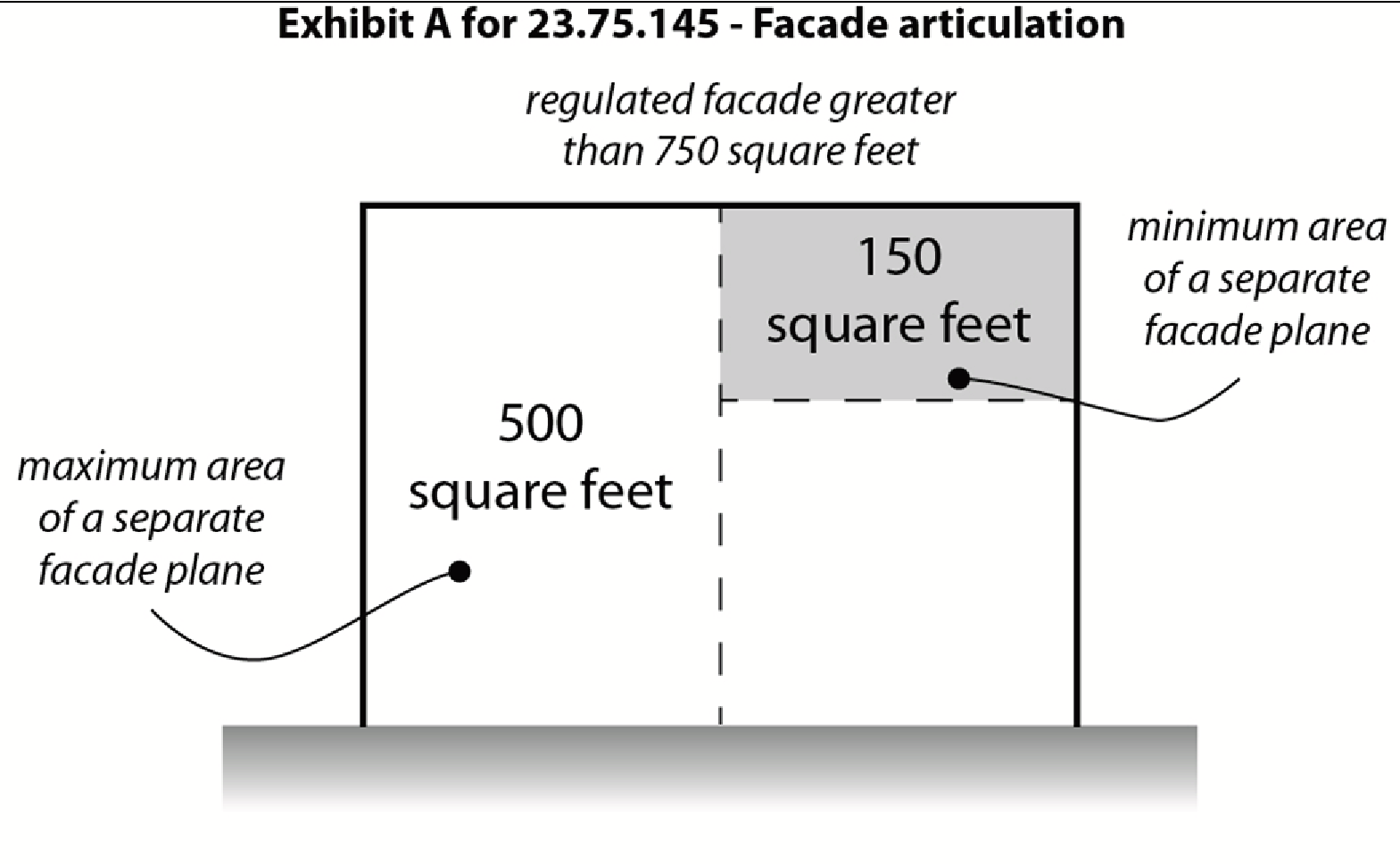
2.
In order to be considered a separate façade plane for the purposes of this subsection 23.75.145.D, a portion of the façade shall have a minimum area of 150 square feet and a maximum area of 500 square feet, and shall project or be recessed from abutting façade planes by a minimum depth of 18 inches.
3.
Trim that is a minimum of 0.75 inches deep and 3.5 inches wide is required to mark roof lines, porches, windows and doors on all regulated facades.
E.
The Director may allow exceptions to the façade articulation requirements in this Section 23.75.145, if the Director determines that the façade will meet the intent of subsection 23.75.145.A through one or more of the following façade treatments:
1.
Variations in building materials and/or color, or both, that reflect the stacking of stories or reinforce the articulation of the façade;
2.
Incorporation of architectural features that add interest and dimension to the façade, such as porches, bay windows, chimneys, pilasters, columns, cornices, and/or balconies; or
3.
Landscaping elements such as trellises or modular green walls that accommodate vegetated walls covering a minimum of 25 percent of the façade surface.
(Ord. 123963, § 26, 2012.)
23.75.150 - Residential amenity areas
A.
Amount required. The required amount of amenity area is equal to 5 percent of the total residential gross floor area.
B.
General requirements.
1.
All dwelling units shall have access to a common amenity area or private amenity area.
2.
No more than 50 percent of the required amenity area may be enclosed within a structure. Enclosed area within a structure that is not common amenity area does not count as required amenity area.
3.
Required amenity area that is not enclosed shall be open to the sky, except for any overhead weather protection or balconies, and except that structural projections that do not provide floor area, such as garden windows, may extend up to 2 feet into a required amenity area if they are at least 8 feet above the surface of the amenity area.
4.
Areas open to the public by easement do not qualify as required amenity areas. Portions of a pedestrian pathway that are not subject to a public easement may qualify as required amenity area.
5.
Parking areas, access drives, and driveways do not qualify as required amenity areas, except that portions of an access drive other than driving surfaces, parking surfaces, or areas dedicated to public use by easement may provide a maximum of 50 percent of the required amenity area.
6.
Pursuant to subsection 23.57.011.C.1, rooftop areas adjacent to minor communication utilities or accessory communication devices do not qualify as required amenity areas.
C.
To count as required amenity area in Blocks 6 and 7, unenclosed amenity areas must be separated from Interstate 5 by an intervening structure a minimum of 10 feet in height, other than a fence or rail.
D.
Common amenity area requirements. This subsection 23.75.150.D applies to common amenity area counted as required amenity area.
1.
Common amenity areas are allowed to be shared among dwelling units in multiple structures on a lot or among lots within the same block, or both. Where a common amenity area is shared among lots:
a.
All residents of all lots among which the amenity area is shared shall have access to the common amenity area, and the total common and private amenity area shall meet or exceed the amenity area requirements for all residential uses on all those lots combined.
b.
A certificate of occupancy shall not be issued for a residential structure for which a permit has been issued based on shared amenity area until all dwelling units in that structure have access to amenity area sufficient to meet the requirements of this Section 23.75.150.
2.
Each common amenity area is required to be at least 250 square feet in area and is required to have a minimum horizontal dimension of 10 feet. For an unenclosed common amenity area, the minimum area and dimension shall be reduced by 30 percent if the applicant demonstrates that the unenclosed common amenity area is an extension of an enclosed common amenity area.
3.
Common amenity area is required to include elements that enhance the usability and livability of the space for residents, such as seating, outdoor lighting, weather protection, or art.
E.
Private amenity area.
1.
To count toward the required amount of amenity area in subsection 23.75.150.A, any single private amenity area must have an area no less than 30 square feet, and is required to have a minimum horizontal dimension of 5 feet.
2.
Gardening in pots and planters shall be allowed in private amenity areas that are counted toward the minimum required amenity area, and no lease provision, covenant, agreement, or rule that prohibits or penalizes such gardening in any such area shall be made or enforced.
(Ord. 123963, § 26, 2012.)
23.75.160 - Landscaping, street trees, and tree protection
A.
Landscaping requirements
1.
Standards. All landscaping provided to meet requirements under this Section 23.75.160 is required to meet standards promulgated by the Director to provide for the long-term health, viability, and coverage of plantings.
2.
Green Factor requirement. A minimum Green Factor score of 0.30, computed pursuant to Section 23.86.019 except as otherwise provided in this Section 23.75.160, is required for any lot with development containing:
a.
More than four dwelling units built after January 1, 2012;
b.
More than 4,000 square feet of nonresidential uses built after January 1, 2012; or
c.
More than 20 automobile parking spaces built after January 1, 2012.
3.
Landscape elements provided within pedestrian pathways, access drives, or parks may not be counted toward meeting the minimum requirement in subsection 23.75.160.A.2.
B.
Street tree requirements. Street trees are required when a proposed development is on a lot that abuts a street. Existing street trees shall be retained unless removal is approved by the Director of Transportation. The Director, in consultation with the Director of Transportation, shall determine the number, type, and placement of street trees to be provided in order to:
1.
Improve public safety;
2.
Promote compatibility with existing street trees;
3.
Match trees to the available space in the planting strip;
4.
Maintain and expand the urban forest canopy;
5.
Encourage healthy growth through appropriate spacing;
6.
Protect utilities; and
7.
Allow access to the street, structures, and lot.
C.
Except for any proposal that meets the planned action ordinance within the MPC zone, Chapter 25.11 shall apply to proposed development. All proposed development shall comply with the requirements of Sections 25.11.050, 25.11.070, and 25.11.080.
(Ord. 125603, § 68, 2018; Ord. 123963, § 26, 2012.)
23.75.170 - Street-level development standards
A.
The standards in this Section 23.75.170 apply to the portion of a regulated facade between 18 inches and 12 feet above finished grade at the base of the facade.
B.
Blank façade segments.
1.
For purposes of this Section 23.75.170, Section 23.86.028 does not apply, and facade segments are considered blank where the portion identified in subsection 23.75.170.A does not include at least one of the following:
a.
Windows, not including glass blocks or opaque glass;
b.
Entryways or doorways, not including doors or entryways to garages, utilities, or loading access;
c.
Stairs, stoops, or porticos; or
d.
Decks or balconies.
2.
Blank segments may not exceed 15 feet in width, except that a blank segment up to 30 feet in width is allowed if the Director determines, as a Type I decision, that the blank segment will be enhanced by architectural detailing, artwork, vegetated wall, or similar features to provide visual interest.
3.
Blank segments shall be separated from one another by at least one feature listed in subsection 23.75.170.B.1 that is at least two feet wide.
C.
Standards for units at regulated facades. This subsection 23.75.170.C applies where dwelling units or live-work units abut a regulated facade.
1.
Except as otherwise provided in this subsection 23.75.170.C.1, each dwelling unit with its lowest floor level 6 feet or less above finished grade and facing onto a street or park open to the public shall have direct access to a private amenity area located between the dwelling unit and the park or street. The floor level at the doorway providing access from the dwelling unit to the amenity area shall not be lower than finished grade at the closest point of the closest boundary. Private amenity area between the dwelling unit and the park or street is not required:
a.
Along Boren Avenue or Boren Avenue S.;
b.
Where the setback is reduced pursuant to subsection 23.75.140.B; or
c.
Where a dwelling unit is located above a residential lobby, common amenity area, or non-parking, non-residential use in the first story partially or completely above grade, and where a built-to line or reduced setback applies pursuant to Section 23.75.140.
2.
At least 20 percent of the facade area shall consist of doors and/or transparent windows. Where live-work units abut the facade, at least 50 percent of the facade area shall consist of doors and/or transparent windows.
3.
Where finished grade along the boundary is sloped greater than 7.5 percent for a segment at least 30 feet long, the requirements of subsection 23.75.170.C.2 are reduced by 50 percent.
D.
Standards for non-residential uses, residential lobbies, and residential amenity areas near finished grade. This subsection 23.75.170.D applies to each façade regulated by 23.75.170.A where the façade does not abut a dwelling unit or live-work unit.
1.
For façades located less than 10 feet from a boundary, at least 75 percent of the area of the façade shall consist of doors and/or transparent windows.
2.
For façades located 10 feet or more from a boundary, at least 50 percent of the area of the façade shall consist of doors and/or transparent windows.
3.
Where finished grade along the boundary is sloped greater than 7.5 percent for a segment at least 30 feet long, the requirements in this subsection 23.75.170.D are reduced by 50 percent.
(Ord. 124378, § 75, 2013; Ord. 123963, § 26, 2012.)
23.75.180 - Parking
A.
Parking is regulated by this Section 23.75.180 and not by Sections 23.54.015, 23.54.016, 23.54.030.A, or 23.54.030.B, except for bicycle parking, which is required pursuant to subsection 23.54.015.K. Parking maximums in this Section 23.75.180 do not include parking for dwelling units existing as of January 1, 2012, so long as those units exist.
B.
There is no minimum requirement for parking spaces for motor vehicles. Maximum motor vehicle parking space limits are as follows:
1.
For the NW Sector, parking shall not exceed 1,350 spaces, plus 0.7 spaces per dwelling unit or live-work unit in the sector, except that up to an additional 450 parking spaces may be permitted as a special exception pursuant to Chapter 23.76. When deciding whether to grant a special exception, the Director shall consider evidence of parking demand for nonresidential uses and alternative means of transportation, including but not limited to the following:
a.
Whether the additional parking will substantially encourage the use of single occupancy vehicles;
b.
Characteristics of the work force and employee hours, such as multiple shifts that end when transit service is not readily available;
c.
Proximity of transit lines to the lot and headway times of those lines;
d.
Whether the additional parking will adversely affect vehicular and pedestrian circulation in the area; and
e.
Potential for shared use of additional parking as residential or short-term parking.
2.
For the NE, SE, and SW Sectors, Table A for 23.75.180 establishes maximum parking allowed based on the uses on a lot, subject to any transfer of unused parking allowance between lots in the same sector under Section 23.75.040.
Table A for 23.75.180
Maximum motor vehicle parking limits for NE, SE, and SW Sectors
C.
Barrier-free parking is required consistent with Seattle Building Code requirements.
D.
For purposes of this Section 23.75.180, all parking is classified as "surface parking," as defined in Section 23.84A.030, or as "aboveground," "partially underground," or "underground," as shown in Exhibit A for 23.75.180 and described as follows:
1.
"Aboveground parking" means any portion of a parking garage where:
a.
the structure projects more than 4 feet in height above finished grade within 30 feet of a build-to line or reduced setback area; or
b.
the structure projects more than 6 feet in height above finished grade in any other location.
2.
"Partially underground parking" means any portion of a parking garage where:
a.
the structure projects 4 feet or less in height above finished grade within 30 feet of a build-to line or reduced setback area; or
b.
the structure projects 6 feet or less in height above finished grade along any other location where the grade along the boundary has a slope of less than 6 percent; or
c.
the structure projects 10 feet or less in height above finished grade along any other location where the grade along the boundary has a slope of 6 percent or greater.
3.
"Underground parking" means a story of parking garage where all floor area, walls, and ceiling structure are entirely below finished grade, excluding access.
Exhibit A for 23.75.180
Structured Parking Classification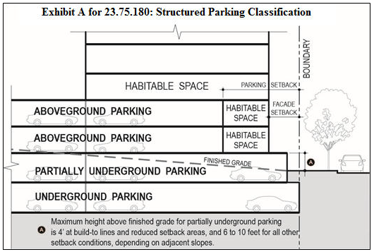
E.
Standards for surface parking.
1.
The total number of surface parking spaces may not exceed 12 spaces per block.
2.
No more than five surface parking spaces may abut one another, and each group of abutting surface parking spaces shall be separated from other surface parking spaces by a minimum of 30 feet, measured between the two closest spaces.
3.
Parking spaces located on an access drive are not allowed within 30 feet of entrances to parking garages.
4.
Surface parking is not allowed in the required setback between a building and a street or park that is open to the public.
F.
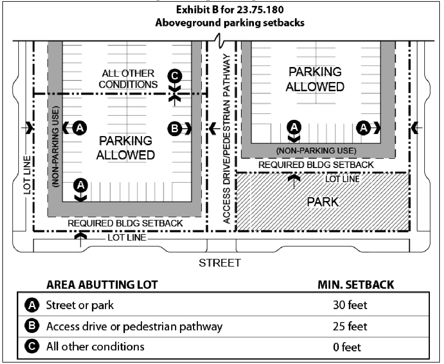
Aboveground parking is subject to the following requirements.
1.
Minimum setbacks for aboveground parking are established in Exhibit B for 23.75.180. No parking setbacks are required from lot lines abutting the Interstate 5 right-of-way.
2.
Parking within 50 feet of a street, park that is open to the public, access drive, or pedestrian pathway may not exceed three levels of aboveground parking.
3.
Aboveground parking and loading areas shall be separated from each regulated facade by a normally occupied use along at least 80 percent of the width of the regulated facade, except where parking access and/or loading access occurs. The remaining part of the façade shall include architectural detailing, artwork, vegetated walls, or other landscape features, with an opaque screen at least 3.5 feet high on each story.
4.
If aboveground parking or an aboveground loading area abuts any façade other than a regulated façade, that façade shall be enhanced with architectural detailing, artwork, vegetated walls, or other landscape features. Each story shall have an opaque screen at least 3.5 feet high.
G.
Partially underground parking is subject to the following requirements:
1.
At build-to lines and in reduced setback areas as depicted in Exhibit C for 23.75.140, partially underground parking is required to be set back at least 2 feet from the boundary, as shown in Exhibit C for 23.75.180. In these locations, the aboveground portion of the parking garage is not allowed to exceed 4 feet above finished grade.
2.
Along boundaries that do not abut a street, park that is open to the public, pedestrian pathway, or access drive, no setback is required for partially underground parking.
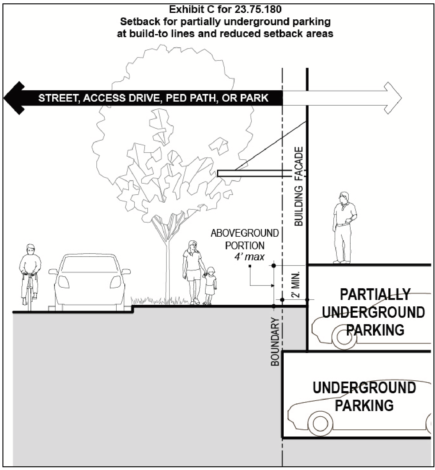
3.
Along boundaries that abut a street, park that is open to the public, pedestrian pathway, or access drive and are not subject to a build-to line or reduced setback area, partially underground parking is required to be set back at least 4 feet from the boundary, as shown in Exhibit D for 23.75.180, and must meet the following standards:
a.
The aboveground portion is required to be no higher than 6 feet above the finished grade at the boundary.
b.
If the aboveground portion of the parking garage is taller than 4 feet above finished grade, a wall or planter shall be provided between the parking garage and the boundary, as illustrated in Exhibit D for 23.75.180. The top of this wall or planter shall be at least two feet below the top of the aboveground portion of the parking garage, and the planting area shall be at least 2 feet in width. Vegetation shall be provided at the top of this wall or planter.
Exhibit D for 23.75.180
Setback for Partially Underground Parking in Locations Other Than Build-to Lines and
Reduced Setback Areas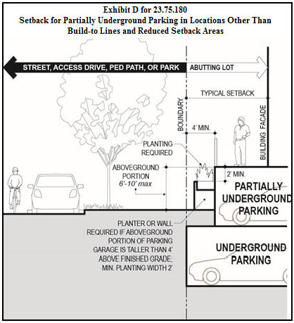
H.
Underground parking may extend to the lot line. The Director may determine, as a Type I Decision, that underground parking may extend beneath private access drives, pedestrian pathways, and parks, provided that:
1.
The underground parking does not conflict with or reduce the quality of public access areas above; and
2.
The underground parking does not interfere with underground public utility alignments established in the Yesler Terrace plat.
I.
Parking and loading access
1.
Access for parking and for loading is required to meet the following requirements:
a.
Access is not allowed within 40 feet of the curb line of an intersection.
b.
Access is not allowed within 20 feet of a structure corner that includes a regulated façade on one or both sides.
2.
Each access drive is required to include a dedicated pedestrian area along at least one side of the length of the drive. The dedicated pedestrian area is required to:
a.
include a walking surface at least 6 feet wide along the length of the access drive; and
b.
be separated from the access drive roadway by a raised curb, bollards, landscaping, or textured paving details.
3.
Curb cuts are required to meet the standards of subsections 23.54.030.F and 23.54.030.G.
4.
Driveways are required to meet the standards of subsection 23.54.030.D.
(Ord. 124843, § 55, 2015; Ord. 123963, § 26, 2012.)