
Saint Petersburg City Zoning Code
SECTION 16
20.110.- INDUSTRIAL SUBURBAN DISTRICT "IS"
Industrial Suburban
Sections:
16.20.110.1.- Composition of industrial suburban.
Many of the City's newer industrial areas range from large-scale buildings located in an office park environment to warehousing, loading and other utilitarian uses on stand-alone sites.
(Code 1992, § 16.20.110.1; Ord. No. 876-G, § 11, 2-21-2008)
16.20.110.2. - Purpose and intent.
The purpose of the IS district regulations is to permit rehabilitation, improvement and redevelopment in a manner that is consistent with the character of the neighborhood and respects adjacent residential uses. This section:
(1)
Creates buffers and transitional zones between industrial corridors and abutting neighborhoods;
(2)
Provides standards and incentives for design including site planning, architectural design, signage and lighting; and
(3)
Establishes guidelines to shield storage areas, walls and fences to provide for a better visual environment.
Flexibility is provided to encourage quality economic development. Residential uses are also permitted in order to provide live-work spaces for artists.
(Code 1992, § 16.20.110.2; Ord. No. 876-G, § 11, 2-21-2008)
16.20.110.3. - Permitted uses.
A.
Uses in this district shall be allowed as provided in the Matrix: Use Permissions and Parking Requirements.
B.
The size of an accessory use which is related to the principal use is subject to any size limits set forth in the plan.
(Code 1992, § 16.20.110.3; Ord. No. 876-G, § 11, 2-21-2008)
16.20.110.4. - Development potential.
Achieving maximum development potential will depend upon market forces, such as minimum desirable size, and development standards, such as minimum lot size, parking requirements, height restrictions and building setbacks.
Minimum Lot Size, Maximum Density and Maximum Intensity
(Code 1992, § 16.20.110.4; Ord. No. 876-G, § 11, 2-21-2008; Ord. No. 203-H, § 25, 11-23-2015)
16.20.110.5. - Building envelope: Maximum height and building setbacks.
Maximum Building Height
Minimum Building Setbacks
(Code 1992, § 16.20.110.5; Ord. No. 876-G, § 11, 2-21-2008)
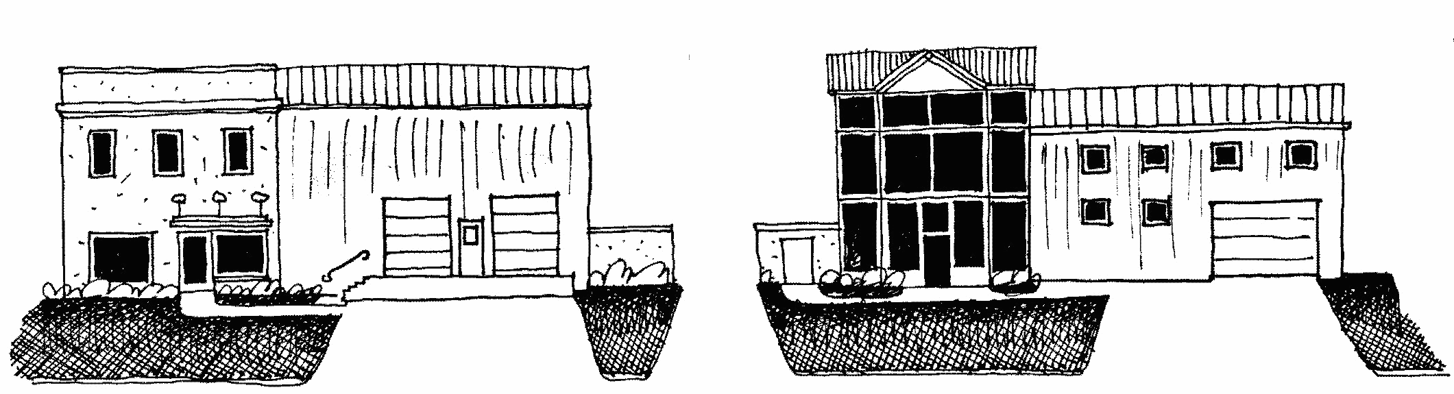
16.20.110.6. - Building design.
The following design criteria allow the property owner and design professional to choose their preferred architectural style, building form, scale and massing, while creating a framework for good urban design practices which create a positive experience for the pedestrian.
Site layout and orientation. The City is committed to creating and preserving a network of linkages for pedestrians. Consequently, pedestrian and vehicle connections between public rights-of-way and private property are subject to a hierarchy of transportation, which begins with the pedestrian.
Building and parking layout and orientation.
1.
All mechanical equipment and utility functions (e.g. electrical conduits, meters, HVAC equipment) shall be located behind the front façade line of the principle structure. Mechanical equipment that is visible from the primary street shall be screened with a material that is compatible with the architecture of the principle structure.
Building and architectural design standards. All buildings should present an inviting, human scale façade to the street, internal drives, parking areas and surrounding neighborhoods. The architectural elements of a building should give it character, richness and visual interest.
Building style. New construction shall utilize an identifiable architectural style which is recognized by design professionals as having a basis in academic architectural design philosophies.
1.
Renovations, additions and accessory structures shall utilize the architectural style of the existing structure, or the entire existing structure shall be modified to utilize an identifiable architectural style which is recognized by design professionals as having a basis in academic architectural design philosophies.
2.
The use of features deemed to be "integral features of a recognized architectural style" shall be compatible with the elevation of a structure, and the pattern, proportions and materials of surrounding structures. The following styles are not recognized architectural styles:
a.
Highway or commercial prototype architecture, unless it is consistent with other requirements of this chapter.
b.
Iconic, advertisement, and other road side attraction architecture. Examples of such include igloos, tepees, quonset huts, castles, plants, animals, foods, and dinosaurs.
3.
All accessory structures, including, but not limited to, drive-throughs, canopies, storage buildings, and solid waste container enclosures, shall be compatible with the architectural design of the principal structure. Compatibility shall be determined by reviewing building materials, finishes and other significant features.
Wall composition. Wall composition standards ensure that ground-level storefronts, and multifamily and single-family residential buildings, offer attractive features to the pedestrian. Wall composition also mitigates blank walls and ensures that all sides of a building have visual interest.
1.
Structures which are situated on corner lots, through lots, or by the nature of the site layout are clearly visible from rights-of-way and public areas of adjoining properties shall be designed with full architectural treatment on all sides visible from public rights-of-way. Full architectural treatment shall include roof design, wall materials, changing textures and colors, and architectural trim, and door and window openings. While it is recognized that buildings have primary and secondary façades, the construction materials and detailing should be similar throughout.
Building materials. Building material standards protect neighboring properties by holding the building's value longer, thereby creating a greater resale value and stabilizing the value of neighboring properties.
1.
Building materials shall be appropriate to the selected architectural style and shall be consistent throughout the project.
2.
Exterior walls shall be constructed of finished materials such as stucco, natural brick or stone, finished concrete, wood or other similar material on all sides. Exposed smooth concrete block or metal finishes shall not be permitted, except where it is an integral feature of a recognized architectural style.
Signage. Signage standards ensure that signage is part of the overall design approach to a project.
1.
Permitted freestanding and wall signs shall be designed to be compatible with the principal structure. Sign boards, canopies, fascias and other architectural features shall be designed to incorporate signage. The base treatment of all freestanding signs shall be compatible with the color, materials and finish of the principal structure.
Accessory structures and equipment. Accessory structures should reinforce the pedestrian character of the City. Above-ground utility and service features should be located and designed to reduce their visual impact upon the streetscape.
1.
Outdoor storage shall not be visible from any non-industrially zoned property or major street. This can be accomplished through the construction of walls, fences or landscaping in accordance with the Code.
2.
Solid waste containers shall not be located within the public rights-of-way. Solid waste containers shall be fully enclosed within a solid, opaque fence or wall that is architecturally compatible with the principal structure and includes shielding gates. Chain link fencing with inserted slats is prohibited.
3.
Solid waste container enclosures located within the front yard shall be landscaped in accordance with City landscaping requirements.
4.
All mechanical equipment (ground or roof), including, but not limited to, air conditioning condensers, heating units, electric meters, satellite dishes, irrigation pumps, ice machines and dispensers, outdoor vending machines, and propane tanks, displays and refilling areas, visible from the public right-of-way, an adjacent neighborhood zoning district or adjacent residential use shall be screened using architectural features consistent with the principal structure.
5.
Any fence or wall which is visible from any public right-of-way shall be designed as an integral feature of the architectural design of the principal structure. Such design shall include the use of similar materials, colors and finishes as the principal structure. A fence or wall shall have breaks, columns or bends and shall incorporate required landscaping.
a.
The use of walls or fences, except chain-link fences, around retention areas is allowed.
b.
The use of chain-link fences shall only be allowed for properties which do not front on a major street or where existing vegetation or proposed landscaping will screen the fence from view from the major street.
6.
External downspouts shall be enclosed within the building structure on the front and side façades and any other façade visible from a right-of-way.
7.
Site furnishings including benches, bicycle racks, light standards, trash receptacles, newspaper racks, and other similar features shall be compatible with the architectural design of the principal structure, and, if located within a planned industrial development, consistent with a uniform program established for all properties within the development.
(Code 1992, § 16.20.110.6; Ord. No. 876-G, § 11, 2-21-2008; Ord. No. 1029-G, § 24, 9-8-2011; Ord. No. 287-H, § 41, 7-20-2017)