
Saint Petersburg City Zoning Code
SECTION 16
20.150.- RETAIL CENTER DISTRICTS "RC"

RC General
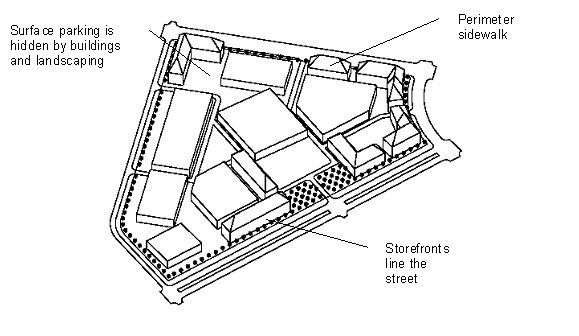
Site Plan of a Typical Development in RC District
Sections:
16.20.150.1.- Composition of retail center.
The retail center development pattern includes a blending of traditional and contemporary design aesthetics, densities and uses, creating a regional commercial destination that is more compatible with the suburban character of the surrounding neighborhoods.
These mixed-use districts are characterized by a collection of compatible, interrelated uses that include shopping, service, employment and residential opportunities. The symbiotic relationship of these mixed uses creates a more balanced community, reduces traffic, consolidates service delivery, and benefits the surrounding residential areas that are within walking distance.
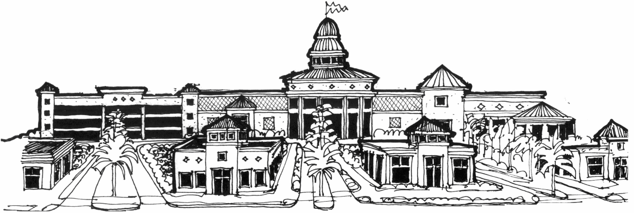
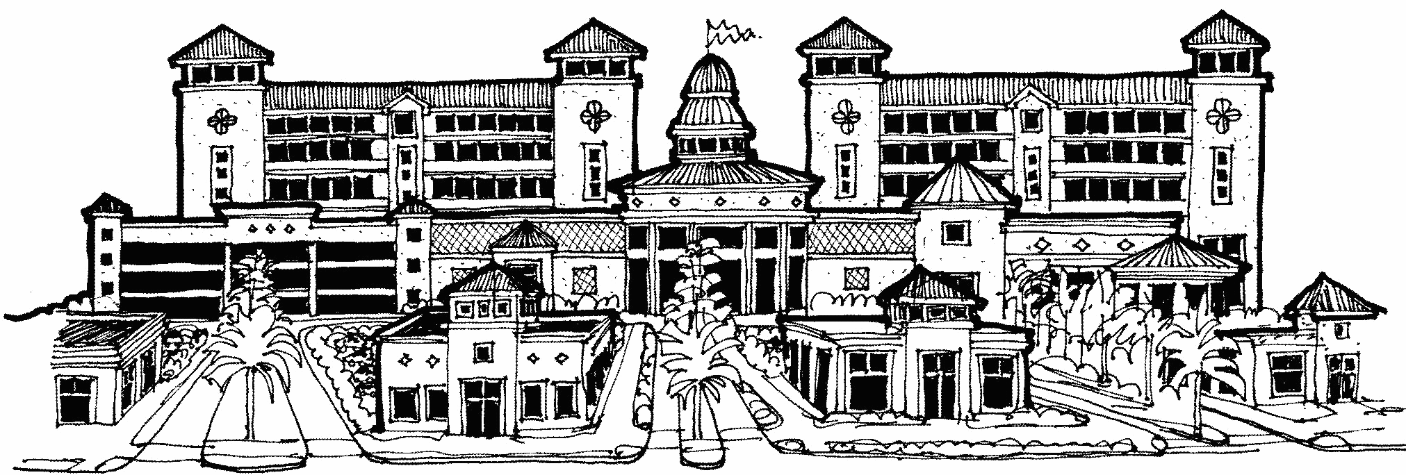
The buildings in retail centers often exhibit a mixture of traditional and contemporary architecture. Buildings typically face all streets with setbacks that are dependent upon the size of the property. Big box buildings shall be edged with linear buildings containing retail, office or residential uses along streets or have architectural details such as large display windows, use of natural materials and other fenestrations. Primary entries shall face the street and be enhanced with architecturally appropriate features.
Historically, the development of retail centers was most influenced by the automobile. Consequently, the regulations of this district recognize that retail center development is driven by the automobile. Regulations of site design, building design, scale and intensity are provided to balance the impacts of parking lots, drive-throughs, and national chain architecture with pedestrian access and safety.
(Code 1992, § 16.20.150.1)
16.20.150.2. - Purpose and intent.
The purpose of the RC district regulations is to protect the suburban character of the surrounding neighborhoods while improving the appearance of retailers, restaurants and other uses, accommodating both vehicles and pedestrians, improving connections between the individual developments, and minimizing automobile dependency. The RC district regulations feature building setbacks, landscaping, internal pedestrian amenities, cross access among developments and other standards to minimize potential visual and traffic impacts.
(Code 1992, § 16.20.150.2)
16.20.150.3. - Permitted uses.
16.20.150.3.1. Uses in this district shall be allowed as provided in the Matrix: Use Permissions and Parking Requirements.
16.20.150.3.2. Uses abutting primary streets.
In the RC-3 zoning district only, developments abutting primary streets or ground level open space shall contain at least 75 percent of the linear building frontage as nonresidential, pedestrian oriented uses. Nonresidential uses shall have an average minimum depth of 40 feet and may include, but not be limited to, retail sales, service establishments, restaurants and bars, hotel lobbies, and residential support activities (e.g. lobbies, fitness centers) as allowed by the Use Permissions And Parking Requirement Matrix.
16.20.150.3.3. Uses abutting all other streets.
In the RC-3 zoning district only, developments abutting all other streets shall contain at least 50 percent of the linear building frontage as active, pedestrian oriented uses. Active, pedestrian oriented uses shall have an average minimum depth of 40 feet and may include, but not be limited to, retail sales, service establishments, restaurants and bars, hotel lobbies, residential, and residential support activities (e.g. lobbies, fitness centers) as allowed by the Use Permissions And Parking Requirement Matrix.
(Code 1992, § 16.20.150.3; Ord. No. 131-H, § 4, 12-18-2014)
16.20.150.4. - Introduction to RC districts.
The Retail Center (RC) districts are the RC-1, RC-2 and RC-3 districts.
16.20.150.4.1. Retail Center-1 (RC-1).
This district allows retail development containing mixed uses with accessory office or multifamily structures. Additional building height and density is allowable within activity centers. Additional density is allowable when workforce housing is provided.
16.20.150.4.2. Retail Center (RC-2).
This district allows retail development or mixed uses with accessory office and multifamily structures. Additional building height and density is allowable within activity centers. Additional density is allowable when workforce housing is provided.
16.20.150.4.3 Retail Center (RC-3).
To enhance development opportunities within an activity center, this district allows retail, office, residential and mixed-use development at greater densities and intensities than the RC-1 and RC-2 zoning districts. Developments proposed within the RC-3 zoning district that include multiple buildings are required to create a master plan in accordance with the City's site plan review procedures. The master plan shall demonstrate compliance with all requirements of this zoning district and Chapter 16.
(Code 1992, § 16.20.150.4; Ord. No. 131-H, §§ 5, 6, 12-18-2014)
16.20.150.5. - Development potential.
Development potential is slightly different within the districts to respect the character of the neighborhoods. Achieving maximum development potential will depend upon market forces, such as minimum desirable unit size, and development standards, such as minimum lot size, parking requirements, height restrictions and building setbacks.
Minimum Lot Size, Maximum Density and Maximum Intensity
(Code 1992, § 16.20.150.5; Ord. No. 876-G, § 16, 2-21-2008; Ord. No. 131-H, § 7, 12-18-2014; Ord. No. 166-H, § 3, 5-21-2015; Ord. No. 203-H, § 25, 11-23-2015; Ord. No. 405-H, § 4, 12-12-2019)
16.20.150.5.1. - Exemptions from FAR calculations.
All projects within an RC-3 (Activity Center) zoning district may qualify for exemptions to the FAR calculations. All areas of a structure are counted to determine the FAR including gross floor area associated with stair and elevator towers and all enclosed common areas, unless noted otherwise.
(Ord. No. 131-H, § 8, 12-18-2014)
16.20.150.5.2. - Bonuses to FAR calculations.
Projects within the RC-3 (Activity Center) zoning district may qualify for an additional intensity bonus up to 1.0 FAR for a cumulative development potential not to exceed 4.0 FAR.
These bonuses are specifically written to provide public amenities and to mitigate secondary impacts associated with the additional development rights. Projects receiving FAR bonuses shall not exceed the maximum intensity allowed for the site. To qualify for bonuses:
•
New construction shall comply with the requirements of the building envelope.
•
New construction shall comply with the minimum parking standards.
Once a project has been determined to qualify for bonuses by the POD, the development may utilize any combination of the bonus provisions listed in this subsection to attain the desired additional development rights, except as otherwise limited by these regulations.
(Ord. No. 131-H, § 9, 12-18-2014)
16.20.150.6. - Building envelope: Maximum height and building setbacks.
Maximum Building Height
Minimum Building Setbacks
(Code 1992, § 16.20.150.6; Ord. No. 893-G, § 19, 9-4-2008; Ord. No. 131-H, § 10, 12-18-2014)
16.20.150.7. - Building design.
The following design criteria allow the property owner and design professional to choose their preferred architectural style, building form, scale and massing, while creating a framework for good urban design practices which create a positive experience for the pedestrian.
Site layout and orientation. The City is committed to creating and preserving a network of linkages for pedestrians. Consequently, pedestrian and vehicle connections between public rights-of-way and private property are subject to a hierarchy of transportation, which begins with the pedestrian.
Within the RC-3 zoning district, the following conditions shall also be incorporated into the project site:
1.
At least one designated primary street, developed with sufficient dimensions to include on-street parking, sidewalk cafes and parkway enhancements, such as trees, benches, and hardscape features, shall be provided;
2.
Ground level open space in the form of a plaza or plazas or a park or parks shall be provided and comply with the following conditions:
a.
Shall comprise at least ten percent of the total land area of the project;
b.
Shall not have any portion of a building projecting over it except for balconies, awnings and similar shade structures;
c.
Shall be at least 50 percent pervious; and
d.
Shall be available for use by the public at least during the hours the development is accessible to the public.
Building and parking layout and orientation.
1.
New multi-building development shall relate to the development of the surrounding properties. This means there shall be no internally-oriented complexes which cause rear yards or rear façades to face towards the perimeter of the development.
2.
All service areas and loading docks shall be located behind the front façade line of the principle structure.
3.
All principal structures shall be oriented toward the primary street. The first floor of big box buildings shall be edged with a use liner containing any permitted use (e.g., retail, restaurant, residential) or the entire wall shall include architectural details such as fenestration, large false (or real) display windows, natural finishes and other architectural features.
4.
Buildings shall be located adjacent to streets to improve access and provide walkway connections to bus stops and public sidewalks. (See pedestrian connections.)
5.
All mechanical equipment and utility functions (e.g. electrical conduits, meters, HVAC equipment) shall be located behind the front façade line of the principal structure. Mechanical equipment that is visible from the primary street shall be screened with a material that is compatible with the architecture of the principal structure.
6.
Parking areas shall be compartmentalized with islands as required by the general development standards. Not more than 40 parking spaces shall be allowed between islands to reduce the overall scale of the parking area.
7.
Parking lot location shall be as follows:
a.
For small lots, no parking spaces shall be allowed between the principal building and the primary street.
b.
For medium lots, no more than a double row of parking spaces with a single drive lane shall be allowed between the principal building and the primary street.
c.
For large lots, parking spaces are allowed anywhere on the property but if placed to the rear of the property, provision shall be made to allow current or future out-parcel development following the small lot/out parcel design guidelines.
8.
Parking structures are encouraged to be internal to the site and to include architectural features related to the principal structure. Parking structures shall meet the requirements of the general development standards.
Vehicle connections.
1.
Cross easements connecting an internal vehicle system are encouraged between abutting property owners.
Multimodal and pedestrian connections.
1.
Within the RC-3 zoning district, multimodal connections shall be provided within reasonable proximity to buildings throughout the development and shall include exterior connections to abutting properties and streets. Multimodal connections may include a combination of the following: bicycle, bus and bus rapid transit, trolley, light, commuter and high-speed rail, or other comparable technologies.
2.
Where multiple store fronts or multiple buildings exist within the same development, each use and building shall be connected by an internal sidewalk system that is clearly delineated from the street. The internal sidewalk system shall connect to any public sidewalk that abuts the property.
3.
Cross easements which connect the internal pedestrian system are encouraged between abutting property owners.
4.
Each ground floor multifamily unit or nonresidential use that faces a primary street shall contain a primary entry which faces the primary street. In the RC-3 zoning district, each ground floor multifamily unit or nonresidential use that faces a street shall contain a primary entry which faces the street. The primary entry shall include decorative door surrounds, porches, porticos and stoops.
5.
Where a single building includes separate commercial and residential entrances, each residential entrance shall be raised at least 16 inches above ground level or recessed within the façade to reinforce a privacy zone and distinguish it from the commercial entrances.
Building and architectural design standards. All buildings should present an inviting, human scale façade to the public roadway, internal drives, parking areas and surrounding neighborhoods. The architectural elements of a building should give it character, richness and visual interest.
Building style.
1.
New construction shall utilize an identifiable architectural style which is recognized by design professionals as having a basis in academic architectural design philosophies.
2.
Renovations, additions and accessory structures shall utilize the architectural style of the existing structure, or the entire existing structure shall be modified to utilize an identifiable architectural style which is recognized by design professionals as having a basis in academic architectural design philosophies.
3.
Shopping centers shall provide a unified architectural theme with standardized building materials, finishes, and color schemes.
4.
All accessory structures including, but not limited to, drive-throughs, canopies, storage buildings, and solid waste enclosures shall be compatible with the architectural design of the principal structure. Compatibility shall be determined by reviewing building materials, finishes and other significant features.
Building form.
1.
Buildings should create a width to height ratio of no more than 3:1. Buildings that exceed the width to height ratio of 3:1 shall have architectural fenestration creating a bay system that divides the building design into a maximum ratio of 3:1. This may be done through pilasters, arcades, building line and roof line off-sets, materials and other appropriate architectural features.
2.
Residential projects should provide a width to height ratio of no more than 2:1. Buildings that exceed the width to height ratio of 2:1 shall have architectural fenestration creating a bay system that divides the building design into a maximum ratio of 2:1.
3.
The first floor of each multi-story building shall not be less than 12 feet in height measured to the bottom of the second floor.
Wall composition. Wall composition standards ensure that ground-level storefronts, and multifamily and single-family residential buildings, offer attractive features to the pedestrian. Wall composition also mitigates blank walls and ensures that all sides of a building have visual interest.
1.
Structures which are situated on corner lots or through lots, or which by the nature of the site layout are otherwise clearly visible from rights-of-way, shall be designed with full architectural treatment on all sides that are visible from rights-of-way. Full architectural treatment shall include roof design, wall materials, architectural trim, and doors and windows. While it is recognized that buildings have primary and secondary façades, the construction materials and detailing should be similar throughout.
2.
There shall be no blank façades. All façades shall include fenestration or other architectural features. No façade on any floor shall have a blank area wider than 24 feet or higher than the height between two floors.
Transparency. The provision of transparency enhances visual connections between activities inside and outside buildings, thereby improving pedestrian safety.
1.
At least 50 percent of street level façades of nonresidential uses shall be transparent. The bottom of windows shall begin no higher than two feet above grade level, and the top of all windows and doors shall be no lower than eight feet above grade level. Taller windows are encouraged.
2.
Windows on the street side façades shall be evenly distributed in a consistent pattern.
3.
At least 20 percent of street side façades of residential buildings shall be transparent and at least 15 percent shall be transparent on all other façades.
Roofs. Rooflines add visual interest to the streetscape and establish a sense of continuity between adjacent buildings. When used properly, rooflines can help distinguish between residential and commercial land uses, reduce the mass of large structures, emphasize entrances, and provide shade and shelter for pedestrians.
1.
Buildings shall provide a pitched roof or a flat roof with a decorative parapet wall compatible with the architectural style of the building.
Building materials. Building material standards protect neighboring properties by holding the building's value longer thereby creating a greater resale value and stabilizing the value of neighboring properties.
1.
Building materials shall be appropriate to the selected architectural style and shall be consistent throughout the project.
(Code 1992, § 16.20.150.7; Ord. No. 1029-G, § 28, 9-8-2011; Ord. No. 131-H, §§ 11, 12, 12-18-2014)