
Saint Petersburg City Zoning Code
SECTION 16
40.040.- FENCE, WALL AND HEDGE REGULATIONS
Sections:
16.40.040.1.- Compliance.
All fences, walls and hedges shall comply with the following requirements which relate to height, location and design.
(Code 1992, § 16.40.040.1)
16.40.040.2. - Definitions.
As used in this section:
Decorative as applied to walls means that a wall is masonry with a stucco finish; has a finish of natural materials, such as brick, stone, or glass block; or has a finish which is accepted for use in the industry and approved by the POD.
Decorative as applied to fences means that a fence is made of PVC fence material, wrought iron, or aluminum pickets, or is a painted or stained shadow-box or board-on-board type fence.
Hedge means a continuous arrangement of three or more shrubs which are planted and maintained to create an open space less than two feet wide by six feet high between each shrub.
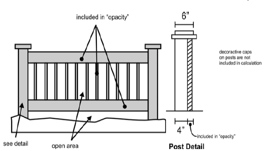
Open means and includes all fence and wall sections which have opacity of 25 percent or less, excluding vertical support posts.
Section is a segment of fence including vertical pickets, any horizontal rails, and one supporting post, except that a post with horizontal dimensions of four inches by four inches or less shall be excluded from the calculations to determine opacity. For a post having dimensions greater than four inches on a side, that part of the dimension greater than four inches shall be included in the calculations to determine opacity.
(Code 1992, § 16.40.040.2)
16.40.040.3. - Charts.
The following charts provide specific regulations and design and other guidelines.
| 1. RESIDENTIAL USES (Including mixed-uses with a residential component; excludes requirements
for waterfront yards - see below) | ||||
|---|---|---|---|---|
|
Front Yards -
Major Streets, except Neighborhood Collectors |
Front Yards -
All other streets | Side Yards, Street Side Yards, and Rear Yards | Street Side - Abutting Neighbor's Front Yard | |
| Maximum Height |
- 4 feet for a fence or wall of any style
- 6 feet for a decorative fence or wall (with the top 2 feet being open), which is landscaped - 6 feet for a hedge |
- 4 feet for a fence or wall of any style
- 5 feet for a hedge - 6 feet for a decorative fence or wall (with the top 2 feet being open),which is landscaped and which is on a property with more than 150 lineal feet of street frontage |
- 6 feet for a fence or wall of any style
- 10 feet for a hedge |
- 4 feet for a fence or wall of any style
- 5 feet for a hedge |
| The diagram at right is intended to provide an illustrative view of the foregoing regulations as applied to rectangular lots platted in the traditional block pattern of the City. For non-rectangular lots or for lots with irregular lot lines, property owners are advised to contact the City to verify interpretation of the ordinance as applied to a specific property. | 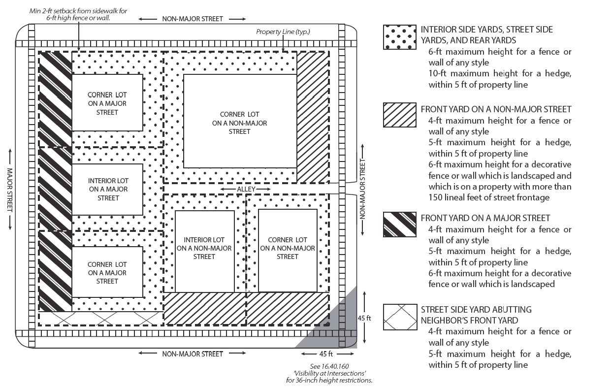 | |||
2.
Waterfront yards (all uses).
| 2. WATERFRONT YARDS (All uses) | |||
|---|---|---|---|
| Maximum Height |
a. - 3 feet for a solid fence or wall of any style and any landscape materials except
protected trees
- 4 feet for an open fence - 5 feet for a decorative open fence for a dock on a non-contiguous water lot, with a maximum gate height of 6 feet, and maximum arch structure height over the gate of 7.5 feet - 6 feet for a vinyl-coated chain-link fence b. In part of the waterfront yard there shall be no limit on the height of landscape materials or number of trees (see 5.E.2, below) |
For IC/CRD-zoned properties
- 10 feet for an open fence |
For commercial marinas
- 6 feet for an open fence |
| The diagram at right is intended to provide an illustrative view of the foregoing regulations as applied to rectangular lots platted in the traditional block pattern of the City. For non-rectangular lots or for lots with irregular lot lines, property owners are advised to contact the City to verify interpretation of the ordinance as applied to a specific property. The crosshatched area shown in the key is intended to illustrate subsection a. above. The dotted area shown in the key is intended to illustrate subsection b. above. 'X' is the setback set forth in the zoning district. | 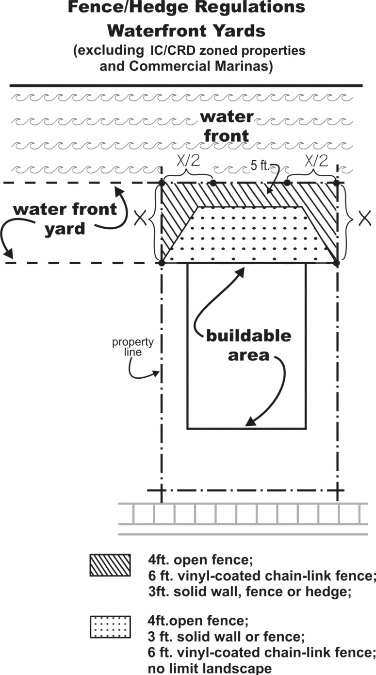 | ||
| 5. DESIGN AND OTHER RELATED REGULATIONS | |
|---|---|
| A. EXEMPTIONS | Fences, walls and hedges on certain properties of the Pinellas County School Board shall be regulated as set forth in an interlocal agreement between the City and the School Board, as may be amended from time to time. |
| B. ALLOWANCES FOR ADDITIONAL HEIGHT | 1. Fences or walls for which a greater height is necessary because of 1) an association with uses that require high fences to protect public safety, such as, but not limited to, driving ranges, utility substations, baseball fields, athletic fields, and swimming pools or 2) a requirement of a state or federal agency, may be allowed subject to a height limit which may be imposed by the POD. Approval of height in excess of that allowed by this Code will be based upon precedent established by previous City approvals, standardized specifications, required security measures, and trajectories for driving ranges and athletic fields. Such fences or walls need not comply with the Design Standards of this section, but shall comply with all landscaping requirements. |
| 2. One (1) additional foot of height is allowed for fence or wall columns which are a maximum of two (2) feet in width and spaced at least six (6) feet apart measured center to center. | |
| 3. Two (2) additional feet of height is allowed for a decorative open arched gate which does not exceed 25 feet in width for a vehicular gate or eight (8) feet in width for a pedestrian gate. | |
4. Four (4) additional feet of height is allowed to accommodate solid arch structures
over gates (as shown below) and other passageways for pedestrians and vehicles.
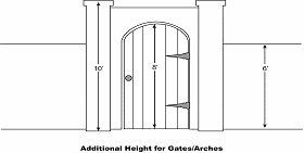 | |
| 5. Two (2) additional feet of height is allowed for decorative lanterns, urns, planters, or sculptural elements above the maximum height allowed for the fence or wall component (e.g. wall, column, or arch) upon which such decorative feature is located. | |
| 6. Maximum height may vary by up to six (6) inches to allow for grade changes, clearance under fences for maintenance, footers, other obstacles customary to the use intended to be fenced, and reasonable human error. | |
| 7. Up to two sections of fence or wall, not to exceed eight (8) feet in width each, may be allowed two (2) additional feet in height within any side (non-street) or rear yard for lattice, planter boxes, or selective screening of adjoining uses. | |
| 8. Fences, walls, or hedges along the side yard of a residential use which abuts a non-residential use may be six (6) feet in height to within five (5) feet of the front property line. | |
| 9. Fences or walls for single-family uses which abut Interstate 275 may be eight (8) feet in height. | |
| C. DESIGN STANDARDS | 1. All fences and walls shall comply with the architectural, design, and landscaping requirements of this code. |
| 2. All fences and walls shall be installed with the finished side facing towards the exterior or adjoining properties and rights-of-way (excluding alleys). For fences and walls between adjoining properties, this requirement may be waived by the POD upon approval by the adjoining property owners, whose written approval shall be signed or acknowledged before a notary. | |
| 3. Barbed wire is prohibited at 1) any residential use; 2) any mixed-use having a residential component; 3) any residentially-zoned property (regardless of its developed use); 4) any property zoned DC or CCT-2; and 5) on any property within ten feet of any property zoned or developed with a residential use. Barbed wire shall be oriented toward the interior of the property and included in the overall fence height measurement. Barbed wire is prohibited on any fence within a yard along a major street. | |
4. On all properties (excluding properties with industrial, single-family, and duplex
uses), fences and walls visible from any street (not including alleys) shall be decorative
or shall be vinyl-coated chain-link (including stands, poles, and rails). Vinyl-coated
chain-link fences and opaque fences or walls more than four feet in height, which
abut a street (not including alleys), shall be setback a minimum of two feet from
the property line and shall be landscaped in accordance with the section regulating
landscaping and irrigation.
 | |
| 5. All fences except chain-link fences shall have upper and lower rails between posts. A chain-link fence shall have a top rail. | |
| 6. Fences and walls shall comply with the design requirements established for the zoning district. | |
| 7. Fences and walls shall be consistent in style and design within any property (e.g. same design in front yard or rear yard), and for yards abutting streets (e.g. same or compatible design and style for both front and street side yards for corner lots). Fences and walls shall be comprised of no more than three materials for panels, posts, rails, columns, and other elements within all yards of any property. Fences and walls in side, rear, and waterfront yards may be comprised of a different material(s) than that used in the front yard. | |
|
8. Fences and walls shall be designed and installed as follows.
a. Fences shall be designed in accordance with industry standard forms such as: stockade, board-on-board, shadowbox, tongue-and-groove, picket, split rail and chain link. An alternative form may be approved where the POD finds that the proposed form complies with the intent of the provisions of this section and that the form requested is at least the equivalent to the industry standard in quality, strength, effectiveness, fire resistance, durability and safety. b. The term building materials shall mean industry standard materials normally manufactured for, used and recognized as fencing materials such as: wrought iron, aluminum or other decorative metals suitable for the construction of fences, masonry, concrete, stone, galvanized and vinyl-coated chain link, wood planks or pickets, and vinyl or composite manufactured specifically as fencing materials. Metal shall have an exterior finish that is not shiny or reflective. The use of metal roofing or metal siding materials is prohibited. An alternative material may be approved where the POD finds that the proposed material complies with the intent of the provisions of this section and that the material requested is at least the equivalent of the industry standard in quality, strength, effectiveness, fire resistance, durability and safety. | |
| 9. Fences and walls greater than 100 feet in length shall be articulated by columns or other visual breaks measuring at least two feet in width and spaced no more than 24 feet apart. Landscaping shall be provided in accordance with the landscaping and irrigation section. This design standard shall apply for any portion of a qualifying fence or wall facing a right-of-way (excluding alleys.) | |
|
10. The attachment of fabric, shade cloth or other material to a chain link or similar
open fence is prohibited except as provided herein. Fabric, shade cloth or other material
is not a permitted method for required screening of outdoor storage areas. Fabric,
shade cloth or other material may be installed to create a wind barrier for athletic
courts or similar situations subject to the following conditions:
a. Professional installation is required by a licensed contractor; b. The proposed material shall be designed to withstand wind resistance with commercial grade seams and attached at grommets designed in a manner consistent with building regulations. | |
| 11. Low voltage electrical fencing is allowed on any property except within the following single-family and multi-family residential districts: NT, NS, NTM, NSM and NPUD; subject to the condition that a nonelectric fence or wall must completely enclose the outside perimeter of the fence, and the electric fence shall be two feet higher than the perimeter nonelectric fence or wall. | |
| 12. Gates and fencing for docks on non-contiguous water lots, and docks on contiguous upland property that are located across a right-of-way or City owned easement from the principal use, shall be open and consist of decorative materials such as wrought iron, aluminum or other decorative metals suitable for the construction of fences, masonry, concrete, stone, and vinyl or composite manufactured specifically as fencing materials. Any fencing projecting beyond the width of the dock as measured at the seawall (the walkway) shall be limited [to] 5 feet in height and 3 feet in width on each side of the walkway. Replacement of a dock or the existing gate or fencing, the replacement of a majority of the pilings, any expansion of the deck area or the addition of a boat lift(s) shall require gates and fences to be brought into compliance. This shall not apply to commercial marinas or properties in the IC/CRD land use category. | |
| BUFFER REQUIREMENTS | ||||
|---|---|---|---|---|
|
Type of Surrounding
Non-Electrical Fence |
Buffer Width Required
(measured from the property line) | Landscaping Required | ||
| Chain Link Fence | 20' | 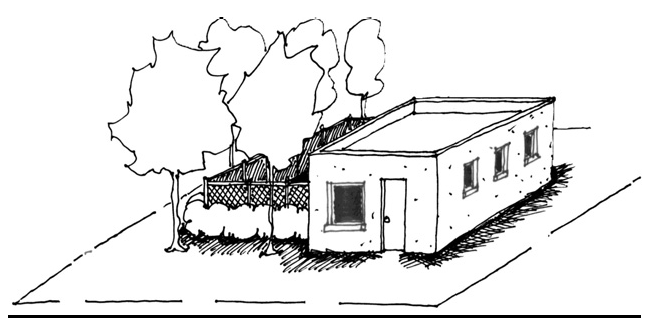 | Trees: At least one shade tree per 50 linear feet (or portion thereof) measuring a minimum of 10' tall and 2.0" diameter at breast height at the time of planting; and | |
| Shrubs: At least on shrub every 30" (measured on center) and measuring a minimum of 24" tall at the time of planting | ||||
| Solid Wood or Solid Vinyl Fence | 15' | 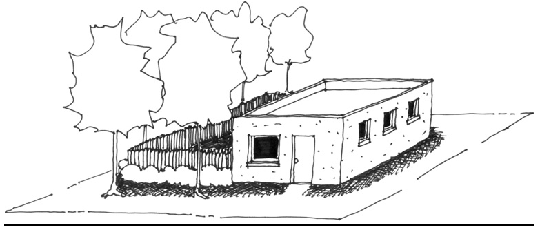 | Trees: At least one shade tree per 50 linear feet (or portion thereof) measuring a minimum of 10' tall and 2.0" diameter at breast height at the time of planting; and | |
| Shrubs: At least on shrub every 30" (measured on center) and measuring a minimum of 24" tall at the time of planting | ||||
| Masonry Wall | 10' | 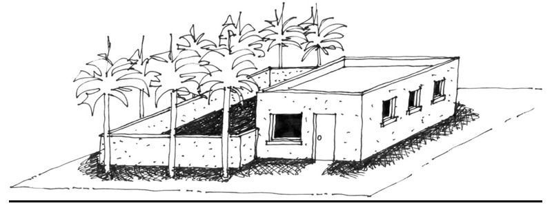 | Palms: At least one palm tree per 20 linear feet (or portion thereof) with a minimum of 10' of clear trunk at the time of planting | |
| NOTE: Where an existing building is located within the buffer area requirement, abutting portions of the electrically charged fencing, and the surrounding non-electrical fence or wall, shall be constructed as close to the building as possible but not in the right-of-way. Portions of the electrically charged fence located within the buffer requirement, shall include at least one sign every 30 linear feet in lieu of the standard sign requirement. | ||||
| g. Any property with electrically charged fencing shall provide safe access for emergency personnel. | ||||
(Ord. No. 985-G, §§ 45—47, 7-15-2010; Ord. No. 1029-G, § 30, 9-8-2011; Ord. No. 123-H, § 3, 8-28-2014; Ord. No. 110-H, § 1, 10-16-2014; Ord. No. 166-H, § 5, 5-21-2015; Ord. No. 203-H, §§ 12—14, 11-23-2015; Ord. No. 287-H, §§ 11, 12, 7-20-2017; Ord. No. 611-H, § 19, 7-10-2025)
Illustration 1
IT-ZONED PROPERTIES
EXEMPT FROM LANDSCAPING REQUIREMENT
(Code 1992, § 16.40.040.3; Ord. No. 985-G, §§ 45—47, 7-15-2010)