
Saint Petersburg City Zoning Code
SECTION 16
20.130.- EMPLOYMENT CENTER DISTRICTS "EC"
EC General
Sections:
16.20.130.1.- Composition of employment center.
The employment center districts are places of concentrated activity focusing on quality employment opportunities with accessory opportunities appropriate to the purpose and intent of each district. This district is designed for business uses which carry on their operation in enclosed facilities in such a manner that no negative impact is created outside of the site boundaries. The district promotes intense employment activity with accessory uses that create aesthetically pleasing environments while allowing the functional interaction of a variety of land use types. All land uses permitted within the district shall meet strict performance standards to discourage offensive odors, noise, fumes, smoke, gases, dust, vibrations and other similar objectionable development impacts.
(Code 1992, § 16.20.130.1; Ord. No. 346-H, § 6, 3-14-2019)
16.20.130.2. - Purpose and intent.
The purpose of the EC district regulations is to allow and encourage the attraction of a variety of uses including all office types, highly specialized and technological industries, research and experimental institutions, light industrial support facilities, and business services. This district shall only be applied to land within activity centers that are identified in the plan.
(Code 1992, § 16.20.130.2; Ord. No. 346-H, § 7, 3-14-2019)
16.20.130.3 - Introduction to EC districts.
The employment center (EC) districts are the EC-1 and EC-2 districts.
(Ord. No. 346-H, § 7, 3-14-2019)
16.20.130.3.1. - Employment center-1 (EC-1).
This district allows a variety of employment-generating uses, focusing on quality employment opportunities which operate in such a manner that no negative impact is created outside of the site boundaries and is primarily intended for the gateway activity center.
(Ord. No. 346-H, § 7, 3-14-2019)
16.20.130.3.2. - Employment center-2 (EC-2).
This district is intended for a mix of uses including institutions devoted to the provision of healthcare and medical services, research and development, marine and life sciences, higher education, business incubation, and media communication, as well as allowing support uses that enable achievement of a mixed-use live-work district.
(Ord. No. 346-H, § 7, 3-14-2019)
16.20.130.4. - Permitted uses.
Uses in this district shall be allowed as provided in the Matrix: Use Permissions and Parking Requirements.
(Code 1992, § 16.20.130.3; Ord. No. 346-H, § 9, 3-14-2019)
Editor's note— Ord. No. 346-H, §§ 8—10, adopted March 14, 2019, repealed §§ 16.20.130.4 and 16.20.130.5 and renumbered § 16.20.130.3 as § 16.20.130.4 and § 16.20.130.6 as § 16.20.130.5. Former §§ 16.20.130.4 and 16.20.130.5 pertained to requirements for master development plans and requirements for multifamily developments; Sod Farm property only, respectively and derived from §§ 16.20.130.4 and 16.20.130.5 of the Code of 1992.
16.20.130.5. - Development potential.
Achieving maximum development potential will depend upon market forces, such as minimum desirable unit size, and development standards, such as minimum lot size, parking requirements, height restrictions, and building setbacks.
Minimum Lot Size, Maximum Density and Maximum Intensity
(Code 1992, § 16.20.130.6; Ord. No. 876-G, § 14, 2-21-2008; Ord. No. 985-G, § 34, 7-15-2010; Ord. No. 166-H, § 3, 5-21-2015; Ord. No. 203-H, § 26, 11-23-2015; Ord. No. 346-H, § 10, 3-14-2019)
Editor's note— See editor's note, § 16.20.130.4.
16.20.130.5.1. - Exemptions from FAR calculations in the EC-2 District.
All areas of a structure are counted to determine the FAR including gross floor area associated with stair and elevator towers and all enclosed common areas, unless noted otherwise. Stand-alone parking garages, even with mixed use on the first floor, shall also be calculated toward FAR except those floors of the garage that are entirely underground.
(Ord. No. 346-H, § 11, 3-14-2019)
16.20.130.5.2. - Bonuses to FAR calculations in the EC-2 District.
Projects within the EC-2 zoning district may qualify for an additional intensity bonus. These bonuses are specifically written to provide public amenities and to mitigate secondary impacts associated with the additional development rights. Projects receiving FAR bonuses shall not exceed the maximum intensity allowed for the site. To qualify for bonuses: a project shall comply with all minimum use requirements of the zoning district; new construction shall comply with the requirements of the building envelope; new construction shall comply with the minimum parking standards.
If the proposed development includes residential dwelling units, the first 0.5 bonus FAR shall be for workforce housing. Thereafter, any bonus or combination of bonuses is allowed.
If the proposed development is replacing a contributing resource to a local landmark district, the first 0.5 bonus FAR shall be through the use of transfer of development rights (TDR, H) purchased from a designated local landmark. Thereafter, any bonus or combination of bonuses is allowed.
Once a project has been determined to qualify for bonuses by the POD, the development may utilize any combination of the bonus provisions listed in this subsection to attain the desired additional development rights, except as otherwise limited by these regulations.
(Ord. No. 346-H, § 12, 3-14-2019)
16.20.130.6. - Building envelope: Maximum height and minimum setbacks.
Maximum Building Height
Minimum Building Setbacks
(Code 1992, § 16.20.130.7; Ord. No. 346-H, § 13, 3-14-2019)
Editor's note— Ord. No. 346-H, § 13, adopted March 14, 2019, renumbered § 16.20.130.7 as § 16.20.130.6.
16.20.130.6.1. - Minimum ground level open space.
A.
Ground level open space shall be required only in the EC-2 district. The minimum ground level open space shall be at least five percent of the total land area of the site. This ground level open space shall not have any portion of a building above it and shall be at least 50 percent pervious. Ground level open space shall be adjacent to the right-of-way, shall be linked to the right-of-way, and shall be available for use by the public during the hours the building is accessible to the public. When a building has at least 50 percent gross floor area of residential uses, the ground level open space may be secured for the exclusive use of the occupants of the building, but shall remain visible to pedestrians along all abutting public sidewalks. Open space includes but is not limited to ground-level courtyards, plazas, sidewalks, and landscaped areas, but does not include parking spaces, driveways, alleys, and other vehicular use areas, nor does it include required vehicular use landscaping areas.
B.
In lieu of providing open space, a payment of one percent of total construction cost may be made into the City's employment center-2 open space fund that will provide for the purchase of new park property, improvement of an existing park or right-of-way within the EC-2 district, or a study or planning project related to the creation or amendment of land development regulations for open spaces within the EC-2 district.
The process to request funding from the employment center-2 open space fund is as follows:
1.
A City Council member or the Mayor makes a request in writing to City Council that purchase of new park property, improvement of an existing park or right-of-way within the EC-2 district, or a study or planning project related to the creation or amendment of land development regulations for open spaces within the EC-2 district be referred, subject to City Council approval, to the Budget, Finance and Taxation Committee for discussion and consideration of funding from the employment center-2 open space fund.
2.
If referred to the Budget, Finance and Taxation Committee, the Committee determines whether to recommend to City Council use of money from the employment center-2 space fund for the purchase of new park property, improvement of an existing park or right-of-way within the EC-2 district, or a study or planning project related to the creation or amendment of land development regulations for open spaces within the EC-2 district. The Committee may also elect to defer action on the request and leave the project on the Committee's pending and continuing referrals list.
3.
If the Budget, Finance and Taxation Committee recommends approval for money from the employment center-2 open space fund for the request, City Council shall consider such recommendation. Appropriation of money from the employment center-2 open space fund is subject to City Council approval.
4.
Applicable contracts for the purchase of new park property, improvement to an existing park or right-of-way within the EC-2 district, or a study or planning project related to the creation or amendment of land development regulations for open spaces within the EC-2 district may be considered by City Council at a future date, in accordance with City Code and Council procedures then in effect.
C.
Sites two acres in size or less are exempt from these minimum ground level open space requirements.
(Ord. No. 346-H, § 14, 3-14-2019; Ord. No. 524-H, § 2, 10-13-2022)
16.20.130.7. - Use regulations and streetscape requirements in the EC-2 district.
Developments within the EC-2 district shall provide nonresidential, pedestrian-oriented uses as prescribed below, and the adjoining public sidewalk shall be improved in compliance with the "Innovation District Streetscape and Connectivity Concept Plan."
(Ord. No. 346-H, § 15, 3-14-2019)
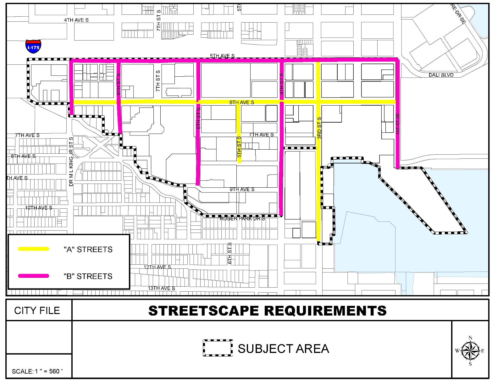
16.20.130.7.1. - Pedestrian level "A" streets within EC-2.
Developments adjoining pedestrian level "A" streets shall include appropriate nonresidential, pedestrian-oriented uses. These uses shall include, but not be limited to, retail sales, service establishments, restaurants and bars, offices, hotel lobbies, hospital lobbies, studios, and limited residential support activities. Such pedestrian-oriented uses shall be incorporated into no less than 75 percent of the linear building frontage abutting all pedestrian level "A" streets. Each of the foregoing pedestrian-oriented uses shall have a minimum average depth of 40 feet and shall meet all requirements of the design guidelines.
(Ord. No. 346-H, § 15, 3-14-2019)
16.20.130.7.2. - Pedestrian level "B" streets within EC-2.
Developments adjoining pedestrian level "B" streets shall include appropriate nonresidential, pedestrian-oriented uses. These uses shall include, but not be limited to, retail sales, service establishments, restaurants and bars, offices, hotel lobbies, hospital lobbies, studios, and limited residential support activities. Such pedestrian-oriented uses shall be incorporated into no less than 60 percent of the linear building frontage abutting all pedestrian level "B" streets. Each of the foregoing pedestrian-oriented uses shall have a minimum average depth of 30 feet and shall meet all requirements of the design guidelines.
(Ord. No. 346-H, § 15, 3-14-2019)
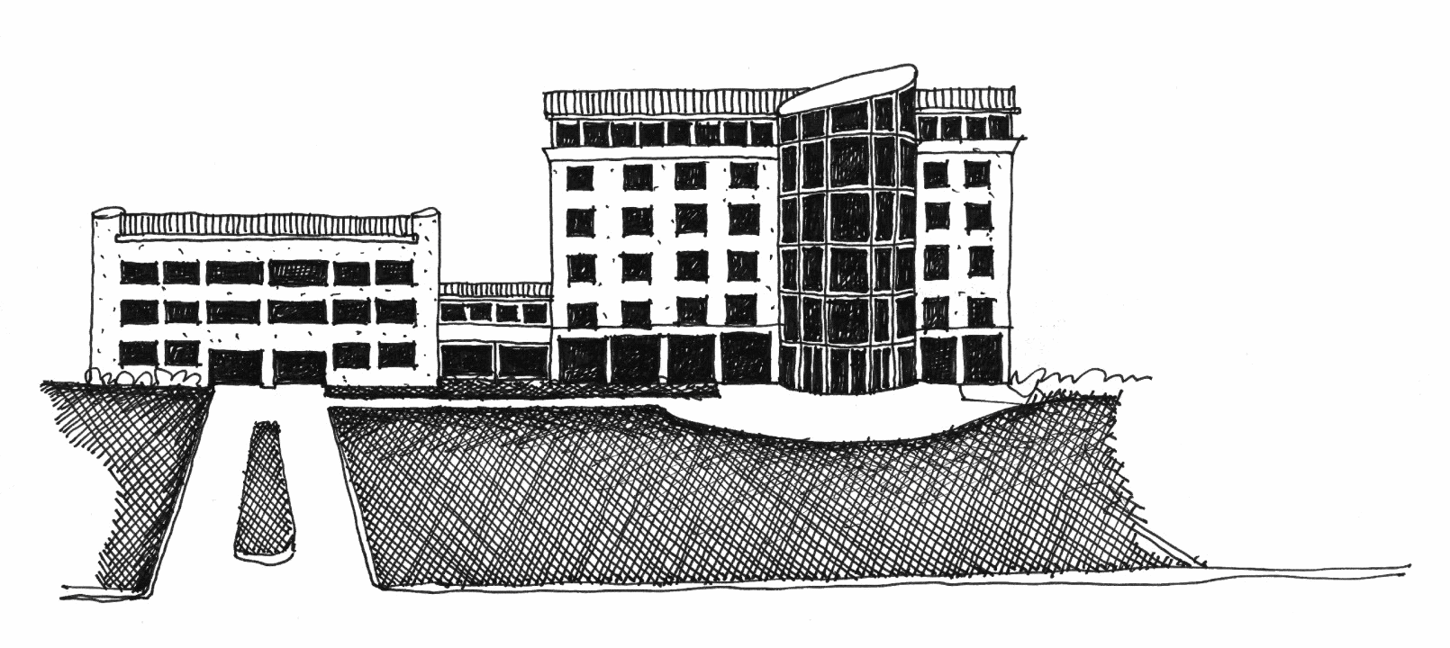
16.20.130.8. - Building design.
The following design criteria allow the property owner and design professional to choose their preferred architectural style, building form, scale and massing, while creating a framework for good urban design practices which create a positive experience for the pedestrian.
Site layout and orientation. The City is committed to creating and preserving a network of linkages for pedestrians. Consequently, pedestrian and vehicle connections between public rights-of-way and private property are subject to a hierarchy of transportation, which begins with the pedestrian.
Building and parking layout and orientation.
In all EC districts:
1.
Buildings shall be located adjacent to streets to improve access and shall provide walkway connections to bus stops and public sidewalks.
Only in the EC-1 district:
1.
All service areas and loading docks and shall be located behind the front façade line of the principal structure.
2.
All mechanical equipment and utility functions (e.g. electrical conduits, meters, HVAC equipment) shall be located behind the front façade line of the principal structure. Mechanical equipment that is visible from the primary street shall be screened with a material that is compatible with the architecture of the principal structure.
3.
Parking structures are encouraged to be internal to the site and include architectural features related to the principal structure and shall meet the general development standards for parking structures.
Only in the EC-2 district:
1.
Surface parking, ancillary equipment, loading and service operations shall be placed to the rear or internal to the property and shall not be visible from streets (not including alleys).
2.
Detention and retention ponds and drainage ditches shall be located behind the principal building to the rear of the property. Detention and retention ponds and drainage ditches shall comply with the design standards set forth in the drainage and surface water management section.
Pedestrian connections.
1.
Where multiple entry features or multiple buildings exist within the same development, each entry feature and building shall be connected by an internal sidewalk system that is clearly delineated from the vehicular pavement. The internal sidewalk system shall connect to any public sidewalk that abuts the property.
2.
Cross easements which connect the internal pedestrian system are encouraged between abutting property owners.
Building and architectural design standards. All buildings should present an inviting, human scale façade to the public roadway, internal drives, parking areas and surrounding neighborhoods. The architectural elements of a building should give it character, richness and visual interest.
Building style.
1.
New construction shall utilize an identifiable architectural style which is recognized by design professionals as having a basis in academic architectural design philosophies.
2.
Renovations, additions and accessory structures shall utilize the architectural style of the existing structure, or the entire existing structure shall be modified to utilize an identifiable architectural style which is recognized by design professionals as having a basis in academic architectural design philosophies. Additions to designated local landmarks are exempt from this regulation but shall comply with all other applicable regulations.
3.
The use of features deemed to be "integral features of a recognized architectural style" shall be compatible with the elevation of a principal structure and the pattern, proportions and materials of surrounding structures. The following shall not be considered recognized architectural styles:
a.
Highway or commercial prototype architecture, unless it is consistent with other requirements of this chapter.
b.
Iconic, advertisement, and other road side attraction architecture. Examples of such include igloos, tepees, quonset huts, castles, plants, animals, foods and dinosaurs.
4.
All accessory structures including, but not limited to, drive-throughs, canopies, storage buildings, and solid waste container enclosures shall be compatible with the architectural design of the principal structure. Compatibility shall be determined by reviewing building materials, finishes and other significant features.
Parking structures and surface parking lots in the EC-2 district only.
1.
Parking structures shall utilize a recognized architectural style.
2.
Parking structures which are part of an overall project shall utilize the same architectural style, fenestration and detailing as the principal structure.
3.
Parking structures shall encase the parking decks with a liner that provides for uses or an architecturally compatible design that creates an attractive façade to screen the structure from the streets (not including alleys).
4.
Surface parking lots which are visible from a street (not including alleys) shall provide a solid knee wall not less than 36 inches high.
Pedestrian building edge and storefronts in the EC-2 district only.
1.
Ground level façades along pedestrian level "A" and pedestrian level "B" streets shall comply with the streetscape requirements. All other ground level façades shall be lined with allowable uses (such as restaurant, retail, residential) or the wall shall include architectural details such as fenestration, display windows, natural finishes, and other architectural features to eliminate blank façades visible from streets (not including alleys).
2.
For non-residential uses, ground level façades along pedestrian level "A" and pedestrian level "B" streets shall have at least 50 percent transparency at the ground level and ground level façades along all other streets shall have at least 30 percent transparency at the ground level.
3.
For non-residential uses, the bottom of windows shall begin no higher than two feet above grade level, and the top of all windows and doors shall be no lower than eight feet above grade level. Taller windows are encouraged.
4.
The ground level of buildings, where the building meets the sidewalk and entryway, should be constructed of high-quality, hardened materials. The use of high-quality materials will protect against damage caused by pedestrian traffic and thereby benefit the lifetime maintenance costs of the building.
Building fenestration in the EC-2 district only.
1.
Buildings shall be equally detailed on all façades visible from a street (not including alleys).
2.
All façades for ground level residential use and all faces for floors above ground level and second floor for non-residential uses shall have at least 30 percent total fenestration. At least two-thirds of this requirement shall be transparent (i.e., window glass).
3.
A zero lot line building or buildings that have interior façades or portions thereof that cannot provide glazing due to building and fire code regulations are exempt from providing fenestration on any exempt portion of the building. Portions of these façades which are not exempt shall have fenestration and architectural detailing consistent with the design style of the building which shall comprise at least 20 percent of the façade. Permanent, durable architectural features such as shutters, tile mosaics, medallions, Trompe L-oeil, or other items are acceptable.
4.
No floor of any street façade shall have a blank area greater than 36 feet in width and the height of the floor. All other façades shall include fenestration and/or architectural features.
5.
Window fenestration on the street façades shall be organized in a rational pattern.
Wall composition. Wall composition standards ensure that ground-level storefronts and multifamily and single-family residential buildings offer attractive features to the pedestrian. Wall composition also mitigates blank walls and ensures that all sides of a building have visual interest.
1.
Structures which are situated on corner lots, through lots, or by the nature of the site layout are clearly visible from rights-of-way shall be designed with full architectural treatment on all sides visible from public rights-of-way. Full architectural treatment shall include roof design, wall materials, and architectural trim, and door and window openings. While it is recognized that buildings have primary and secondary façades, the construction materials and detailing should be similar throughout.
Roofs. Rooflines add visual interest to the streetscape and establish a sense of continuity between adjacent buildings. When used properly, rooflines can help distinguish between residential and commercial land uses, reduce the mass of large structures, emphasize entrances, and provide shade and shelter for pedestrians.
1.
Buildings shall provide a pitched roof or a flat roof with a decorative parapet wall compatible with the architectural style of the building.
Building materials. Building material standards protect neighboring properties by holding the building's value longer, thereby creating a greater resale value and stabilizing the value of neighboring properties.
1.
Building materials shall be appropriate to the selected architectural style and should be consistent throughout the project.
2.
Exterior walls shall be constructed of finished materials such as stucco, natural brick or stone, finished concrete, wood or other similar material on all sides. Exposed smooth concrete block or metal finishes shall not be permitted, except where it is an integral feature of a recognized architectural style.
Signage. Signage standards ensure that signage is part of the overall design approach to a project.
1.
Permitted freestanding and wall signs shall be designed to be compatible and integral with the principal structure. Sign boards, canopies, fascias and other architectural features shall be designed to incorporate signage or a uniform sign program. The base treatment of all freestanding signs shall be compatible with the color, materials and finish of the principal structure.
Accessory structures and equipment. Accessory structures should reinforce the pedestrian character of the City. Above-ground utility and service features shall be located and designed to reduce their visual impact upon the streetscape.
1.
All mechanical equipment (ground or roof), including, but not limited to, air conditioning condensers, heating units, electric meters, satellite dishes, irrigation pumps, ice machines and dispensers, outdoor vending machines, and propane tanks, displays and refilling areas visible from the public right-of-way or adjacent residential use shall be screened using architectural features consistent with the structure or landscaping of sufficient density and maturity at planting to provide opaque screening.
2.
Site furnishings including benches, bicycle racks, light standards, trash receptacles, newspaper racks, and any other similar features shall be compatible with the architectural design of the principal structure.
3.
Any fence or wall which is visible from any public right-of-way shall be designed as an integral feature of the architectural design of the principal structure. Such design shall include the use of similar materials, colors and finishes as the principal structure, shall have breaks, columns or bends and shall incorporate required landscaping.
a.
The use of walls or fences, other than chain-link fences, around retention areas is allowed.
b.
The use of chain-link fences shall only be allowed for properties which do not front on a major street or where existing vegetation or proposed landscaping will screen the fence from view from the major street.
4.
External downspouts shall be enclosed within the building structure on the front and side façades and any other façade visible from a right-of-way.
(Code 1992, § 16.20.130.8; Ord. No. 876-G, § 14, 2-21-2008; Ord. No. 1029-G, § 26, 9-8-2011; Ord. No. 287-H, § 41, 7-20-2017; Ord. No. 346-H, § 16, 3-14-2019)